รูปภาพหรือไฟล์เสียงนี้ ต้นฉบับอยู่ที่ คอมมอนส์ รายละเอียดด้านล่าง เป็นข้อความที่แสดงผลจาก ไฟล์ต้นฉบับในคอมมอนส์ คอมมอนส์เป็นเว็บไซต์ในโครงการสำหรับเก็บรวบรวมสื่อเสรี ที่ คุณสามารถช่วยได้
ความย่อ คำอธิบายÅland2topo.png English:
Suomi:
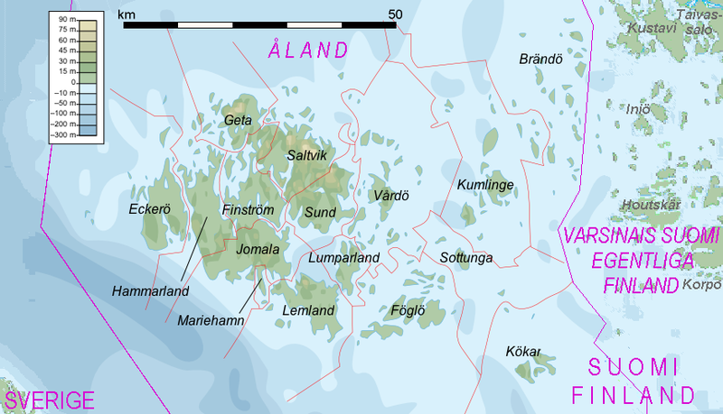
วันที่ 12 กุมภาพันธ์ พ.ศ. 2551 แหล่งที่มา Self-made in Inkscape.http://www.ngdc.noaa.gov/mgg/topo/gltiles.html ).
Westerly an easterly additions using http://www.maps-for-free . ผู้สร้างสรรค์ Mysid, westerly and easterly additions by Ulamm 01:01, 16 March 2008 (UTC)
การอนุญาตใช้สิทธิ ข้าพเจ้า ในฐานะผู้ถือลิขสิทธิ์ของภาพหรือสื่อนี้ อนุญาตให้ใช้ภาพหรือสื่อนี้ภายใต้เงื่อนไขต่อไปนี้
อนุญาตให้คัดลอก แจกจ่ายและ/หรือดัดแปรเอกสารนี้ภายใต้เงื่อนไขของสัญญาอนุญาตเอกสารเสรีของกนู รุ่น 1.2 หรือรุ่นใด ๆ นับจากนี้ที่ออกโดยมูลนิธิซอฟต์แวร์เสรี โดยไม่มีส่วนใดห้ามแก้ไข ไม่มีข้อความปกหน้าและปกหลัง สำเนาของสัญญาอนุญาตรวมอยู่ในส่วนชื่อ สัญญาอนุญาตเอกสารเสรีของกนู http://www.gnu.org/copyleft/fdl.html GFDL GNU Free Documentation License true true
This file is licensed under the Creative Commons Attribution-Share Alike 4.0 International, 3.0 Unported, 2.5 Generic, 2.0 Generic and 1.0 Generic license.
คุณสามารถ: ที่จะแบ่งปัน – ที่จะทำสำเนา แจกจ่าย และส่งงานดังกล่าวต่อไปที่จะเรียบเรียงใหม่ – ที่จะดัดแปลงงานดังกล่าว ภายใต้เงื่อนไขต่อไปนี้: แสดงที่มา – คุณต้องให้เกียรติเจ้าของงานอย่างเหมาะสม โดยเพิ่มลิงก์ไปยังสัญญาอนุญาต และระบุหากมีการเปลี่ยนแปลง คุณอาจทำเช่นนี้ได้ในรูปแบบใดก็ได้ตามควร แต่ต้องไม่ใช่ในลักษณะที่แนะว่าผู้ให้อนุญาตสนับสนุนคุณหรือการใช้งานของคุณอนุญาตแบบเดียวกัน – หากคุณดัดแปลง เปลี่ยนรูป หรือต่อเติมงานนี้ คุณต้องใช้สัญญาอนุญาตแบบเดียวกันหรือแบบที่เหมือนกับสัญญาอนุญาตที่ใช้กับงานนี้เท่านั้น https://creativecommons.org/licenses/by-sa/4.0 CC BY-SA 4.0 Creative Commons Attribution-Share Alike 4.0 true true คุณสามารถเลือกสัญญาอนุญาตดังกล่าวตามต้องการ
Licensing for the additions
ไฟล์นี้อยู่ภายใต้สัญญาอนุญาต ครีเอทีฟคอมมอนส์ แบบแสดงที่มา-อนุญาตแบบเดียวกัน 3.0 ต้นฉบับ
คุณสามารถ: ที่จะแบ่งปัน – ที่จะทำสำเนา แจกจ่าย และส่งงานดังกล่าวต่อไปที่จะเรียบเรียงใหม่ – ที่จะดัดแปลงงานดังกล่าว ภายใต้เงื่อนไขต่อไปนี้: แสดงที่มา – คุณต้องให้เกียรติเจ้าของงานอย่างเหมาะสม โดยเพิ่มลิงก์ไปยังสัญญาอนุญาต และระบุหากมีการเปลี่ยนแปลง คุณอาจทำเช่นนี้ได้ในรูปแบบใดก็ได้ตามควร แต่ต้องไม่ใช่ในลักษณะที่แนะว่าผู้ให้อนุญาตสนับสนุนคุณหรือการใช้งานของคุณอนุญาตแบบเดียวกัน – หากคุณดัดแปลง เปลี่ยนรูป หรือต่อเติมงานนี้ คุณต้องใช้สัญญาอนุญาตแบบเดียวกันหรือแบบที่เหมือนกับสัญญาอนุญาตที่ใช้กับงานนี้เท่านั้น https://creativecommons.org/licenses/by-sa/3.0 CC BY-SA 3.0 Creative Commons Attribution-Share Alike 3.0 true true ไทย เพิ่มคำบรรยายทรรทัดเดียวเพื่อขยายความว่าไฟล์นี้มีอะไร
ประวัติไฟล์ คลิกวันที่/เวลาเพื่อดูไฟล์ที่ปรากฏในขณะนั้น
หน้าที่มีภาพนี้ หน้าต่อไปนี้ โยงมาที่ภาพนี้:
การใช้ไฟล์ส่วนกลาง วิกิอื่นต่อไปนี้ใช้ไฟล์นี้:
ויקיפדיה:איך להקים אסם/תבניות מידע בערכים/מפה מצוירת מיועדת להחלפה במפה דינמית/ק-ת การใช้บน pl.wikivoyage.org
ไฟล, Åland2topo, ไฟล, ประว, ไฟล, หน, าท, ภาพน, การใช, ไฟล, วนกลางขนาดของต, วอย, างน, กเซล, ความละเอ, ยดอ, กเซล, กเซล, กเซล, ภาพท, ความละเอ, ยดส, งกว, 8206, กเซล, ขนาดไฟล, โลไบต, ชน, ดไมม, image, ปภาพหร, อไฟล, เส, ยงน, นฉบ, บอย, คอมมอนส, รายละเอ, ยดด, านล, าง, . ifl prawtiifl hnathimiphaphni karichiflswnklangkhnadkhxngtwxyangni 800 459 phikesl khwamlaexiydxun 320 184 phikesl 640 367 phikesl 861 494 phikesl duphaphthimikhwamlaexiydsungkwa 8206 861 494 phikesl khnadifl 148 kiolibt chnidimm image png rupphaphhruxiflesiyngni tnchbbxyuthi khxmmxns raylaexiyddanlang epnkhxkhwamthiaesdngphlcak ifltnchbbinkhxmmxns khxmmxnsepnewbistinokhrngkarsahrbekbrwbrwmsuxesri thi khunsamarthchwyid khwamyx khaxthibayAland2topo png English Topographic map of the Aland Islands Suomi Ahvenanmaan topografinen kartta wnthi 12 kumphaphnth ph s 2551aehlngthima Self made in Inkscape Boundaries and municipality borders based on Image Alandmunicipalities png Topography based on public domain GLOBE data from NOAA http www ngdc noaa gov mgg topo gltiles html Bathymetry adapted after a small slice from T Seifert F Tauber B Kayser 2001 A high resolution spherical grid topography of the Baltic Sea 2nd edition Baltic Sea Science Congress Stockholm 25 29 November 2001 Poster 147 www io warnemuende de iowtopo Colors and overall look based on maps by User Bamse Westerly an easterly additions using http www maps for free phusrangsrrkh Mysid westerly and easterly additions by Ulamm 01 01 16 March 2008 UTC karxnuyatichsiththi khapheca inthanaphuthuxlikhsiththikhxngphaphhruxsuxni xnuyatihichphaphhruxsuxniphayitenguxnikhtxipni xnuyatihkhdlxk aeckcayaela hruxddaeprexksarniphayitenguxnikhkhxngsyyaxnuyatexksaresrikhxngknu run 1 2 hruxrunid nbcaknithixxkodymulnithisxftaewresri odyimmiswnidhamaekikh immikhxkhwampkhnaaelapkhlng saenakhxngsyyaxnuyatrwmxyuinswnchux syyaxnuyatexksaresrikhxngknuhttp www gnu org copyleft fdl html GFDL GNU Free Documentation License true trueThis file is licensed under the Creative Commons Attribution Share Alike 4 0 International 3 0 Unported 2 5 Generic 2 0 Generic and 1 0 Generic license khunsamarth thicaaebngpn thicathasaena aeckcay aelasngngandngklawtxip thicaeriyberiyngihm thicaddaeplngngandngklaw phayitenguxnikhtxipni aesdngthima khuntxngihekiyrtiecakhxngnganxyangehmaasm odyephimlingkipyngsyyaxnuyat aelarabuhakmikarepliynaeplng khunxacthaechnniidinrupaebbidkidtamkhwr aettxngimichinlksnathiaenawaphuihxnuyatsnbsnunkhunhruxkarichngankhxngkhun xnuyataebbediywkn hakkhunddaeplng epliynrup hruxtxetimnganni khuntxngichsyyaxnuyataebbediywknhruxaebbthiehmuxnkbsyyaxnuyatthiichkbnganniethannhttps creativecommons org licenses by sa 4 0 CC BY SA 4 0 Creative Commons Attribution Share Alike 4 0 true truekhunsamartheluxksyyaxnuyatdngklawtamtxngkar Licensing for the additions iflnixyuphayitsyyaxnuyat khriexthifkhxmmxns aebbaesdngthima xnuyataebbediywkn 3 0 tnchbbkhunsamarth thicaaebngpn thicathasaena aeckcay aelasngngandngklawtxip thicaeriyberiyngihm thicaddaeplngngandngklaw phayitenguxnikhtxipni aesdngthima khuntxngihekiyrtiecakhxngnganxyangehmaasm odyephimlingkipyngsyyaxnuyat aelarabuhakmikarepliynaeplng khunxacthaechnniidinrupaebbidkidtamkhwr aettxngimichinlksnathiaenawaphuihxnuyatsnbsnunkhunhruxkarichngankhxngkhun xnuyataebbediywkn hakkhunddaeplng epliynrup hruxtxetimnganni khuntxngichsyyaxnuyataebbediywknhruxaebbthiehmuxnkbsyyaxnuyatthiichkbnganniethannhttps creativecommons org licenses by sa 3 0 CC BY SA 3 0 Creative Commons Attribution Share Alike 3 0 true truekhabrryayodyyxithyephimkhabrryaythrrthdediywephuxkhyaykhwamwaiflnimixairixethmthiaesdngxyuiniflniprakxbdwysthanalikhsiththimilikhsiththisyyaxnuyatCreative Commons Attribution ShareAlike 1 0 Generic xngkvsCreative Commons Attribution ShareAlike 3 0 Unported xngkvsCreative Commons Attribution ShareAlike 4 0 International xngkvsCreative Commons Attribution ShareAlike 2 5 Generic xngkvsGNU Free Documentation License version 1 2 or later xngkvsCreative Commons Attribution ShareAlike 2 0 Generic xngkvswnthisrang wnkxtng12 kumphaphnth 2008 prawtiifl khlikwnthi ewlaephuxduiflthipraktinkhnann wnthi ewlarupyxkhnadphuichkhwamehn pccubn20 53 17 minakhm 2551861 494 148 kiolibt Ulamm 18 07 16 minakhm 2551861 494 148 kiolibt Ulamm 17 59 16 minakhm 2551861 494 148 kiolibt Ulamm 08 01 16 minakhm 2551861 494 149 kiolibt Ulamm Description en Topographic map of the Aland Islands fi Ahvenanmaan topografinen kartta Source Self made in Inkscape lt br gt Boundaries and municipality borders based on Image Alandmunicipalities png hnathimiphaphni hnatxipni oyngmathiphaphni hmuekaaoxlnd karichiflswnklang wikixuntxipniichiflni karichbn af wikipedia org Aland karichbn dsb wikipedia org Aland karichbn es wikipedia org Fasta Aland karichbn et wikipedia org Turu ja Ahvenamaa positsioon karichbn frr wikipedia org Aland karichbn gl wikipedia org Fasta Aland karichbn he wikipedia org מרייהאמן ויקיפדיה איך להקים אסם תבניות מידע בערכים מפה מצוירת מיועדת להחלפה במפה דינמית ק ת karichbn hsb wikipedia org Aland karichbn nl wikipedia org Aland karichbn no wikipedia org Kategori Personer fra Aland karichbn pl wikipedia org Wyspy Alandzkie karichbn pl wikivoyage org Wyspy Alandzkie karichbn pl wiktionary org Ahvenanmaa karichbn zea wikipedia org Aland ekhathungcak https th wikipedia org wiki ifl Aland2topo png, wikipedia, วิกิ หนังสือ, หนังสือ, ห้องสมุด,
บทความ , อ่าน, ดาวน์โหลด, ฟรี, ดาวน์โหลดฟรี, mp3, วิดีโอ, mp4, 3gp, jpg, jpeg, gif, png, รูปภาพ, เพลง, เพลง, หนัง, หนังสือ, เกม, เกม