This work is licensed under the Government of Japan Standard Terms of Use (Ver.2.0). The Terms of Use are compatible with the Creative Commons Attribution License 4.0 International. For terms of use this work, see this license page.
English ∙ español ∙ 日本語 ∙ 한국어 ∙ македонски ∙ português ∙ slovenščina ∙ Tiếng Việt ∙ 简体中文 ∙ 繁體中文 ∙ +/−
https://creativecommons.org/licenses/by/4.0CC BY 4.0 Creative Commons Attribution 4.0 truetrue
This file, which was originally posted to https://www.gsi.go.jp/, was reviewed on 4 August 2020 by reviewer 廣九直通車, who confirmed that it was available there under the stated license on that date.
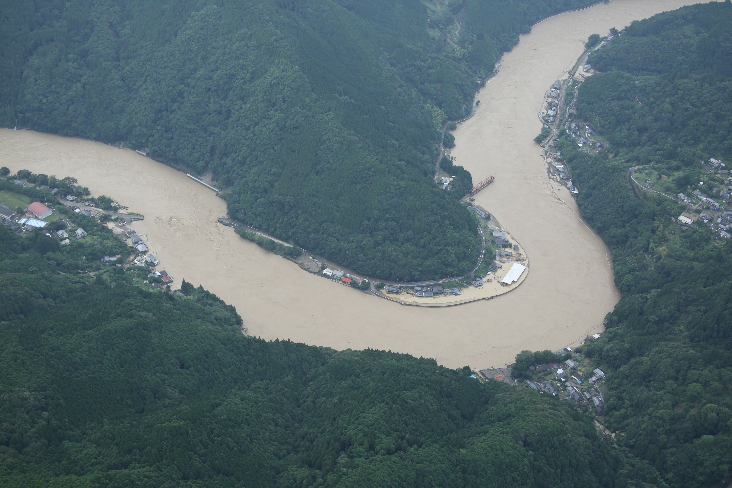
ไฟล, 令和2年, 2020年, 7月3日からの大雨, 斜め写真, 球磨川地区, 熊本県八代市, 芦北町, 球磨村, 124a2643, ไฟล, ประว, ไฟล, หน, าท, ภาพน, การใช, ไฟล, วนกลาง, อม, ลเก, ยวก, บภาพขนาดของต, วอย, างน, กเซล, ความละเอ, ยดอ, กเซล, กเซล, กเซล, กเซล, กเซล, ภาพท, ความละเอ, ยดส, งกว, 8206, กเซล, ขนาดไฟล, เมกะ. ifl prawtiifl hnathimiphaphni karichiflswnklang khxmulekiywkbphaphkhnadkhxngtwxyangni 800 533 phikesl khwamlaexiydxun 320 213 phikesl 640 427 phikesl 1 024 683 phikesl 1 280 853 phikesl 2 880 1 920 phikesl duphaphthimikhwamlaexiydsungkwa 8206 2 880 1 920 phikesl khnadifl 2 73 emkaibt chnidimm image jpeg rupphaphhruxiflesiyngni tnchbbxyuthi khxmmxns raylaexiyddanlang epnkhxkhwamthiaesdngphlcak ifltnchbbinkhxmmxns khxmmxnsepnewbistinokhrngkarsahrbekbrwbrwmsuxesri thi khunsamarthchwyid khwamyx khaxthibay令和2年 2020年 7月3日からの大雨 斜め写真 球磨川地区 熊本県八代市 芦北町 球磨村 124A2643 jpg 日本語 令和2年 2020年 7月3日からの大雨を受けて国土地理院によって行われた現地調査で撮影された空撮写真 1 wnthi 4 krkdakhm ph s 2563 15 35 07 aehlngthima https saigai gsi go jp 1 R2 baiuzensenoame kumagawa naname qv 124A2643 JPG phusrangsrrkh 国土地理院 Geospatial Information Authority of Japan karxnuyatichsiththi This work is licensed under the Government of Japan Standard Terms of Use Ver 2 0 The Terms of Use are compatible with the Creative Commons Attribution License 4 0 International For terms of use this work see this license page English nbsp espanol nbsp 日本語 nbsp 한국어 nbsp makedonski nbsp portugues nbsp slovenscina nbsp Tiếng Việt nbsp 简体中文 nbsp 繁體中文 nbsp iflnixyuphayitsyyaxnuyatkhriexthifkhxmmxns run aesdngthima 4 0 nanachatikaraesdngthima 国土地理院 Geospatial Information Authority of Japan khunsamarth thicaaebngpn thicathasaena aeckcay aelasngngandngklawtxip thicaeriyberiyngihm thicaddaeplngngandngklaw phayitenguxnikhtxipni aesdngthima khuntxngihekiyrtiecakhxngnganxyangehmaasm odyephimlingkipyngsyyaxnuyat aelarabuhakmikarepliynaeplng khunxacthaechnniidinrupaebbidkidtamkhwr aettxngimichinlksnathiaenawaphuihxnuyatsnbsnunkhunhruxkarichngankhxngkhunhttps creativecommons org licenses by 4 0 CC BY 4 0 Creative Commons Attribution 4 0 true true This file which was originally posted to https www gsi go jp was reviewed on 4 August 2020 by reviewer 廣九直通車 who confirmed that it was available there under the stated license on that date khabrryayodyyxithyephimkhabrryaythrrthdediywephuxkhyaykhwamwaiflnimixairxngkvsKamase Bridge left and Kumagawa Railway Bridge No 1 right were washed away frngessLes ponts Kamase gauche et de chemin de fer Kumagawa n 1 droite ont ete emportes par le courant ixethmthiaesdngxyuiniflniprakxbdwyKuma River nbsp xngkvsxuthkphyinkhiwchu ph s 2563sthanalikhsiththimilikhsiththisyyaxnuyatCreative Commons Attribution 4 0 International nbsp xngkvswnthisrang wnkxtng4 krkdakhm 2020bnthukphaphdwyCanon EOS 5D Mark III nbsp xngkvsexposure time nbsp xngkvs0 0015625 winathif number nbsp xngkvs6 3focal length nbsp xngkvs50 milliemtrISO speed nbsp xngkvs500MIME type nbsp xngkvsimage jpegepnphaphthay prawtiifl khlikwnthi ewlaephuxduiflthipraktinkhnann wnthi ewlarupyxkhnadphuichkhwamehn pccubn04 30 6 krkdakhm 25632 880 1 920 2 73 emkaibt 片割れ靴下 hnathimiphaphni hnatxipni oyngmathiphaphni xuthkphyinkhiwchu ph s 2563 karichiflswnklang wikixuntxipniichiflni karichbn ar wikipedia org فيضانات كيوشو 2020 karichbn de wikipedia org Uberschwemmungen auf Kyushu 2020 karichbn en wikipedia org 2020 Kyushu floods karichbn es wikipedia org Inundaciones de Kyushu de 2020 karichbn fa wikipedia org سیل ۲۰۲۰ کیوشو karichbn ko wikipedia org 2020년 7월 일본 호우 karichbn ms wikipedia org Banjir Kyushu 2020 karichbn ne wikipedia org सन २०२० क य स ब ढ karichbn pt wikipedia org Inundacoes em Kyushu em 2020 karichbn sr wikipedia org Poplave na ostrvu Kјushu 2020 karichbn vi wikipedia org Lũ lụt Kyushu 2020 karichbn zh wikipedia org 2020年7月日本水災khxmulekiywkbphaph phaphnimikhxmulephimetim sungswnihymacakklxngdicitxlhruxsaeknenxrthisamarthekbkhxmuldngklawiwrwmkbphaphid thaphaphnithukprbprungaekikhhruxepliynaeplngcakedim khxmulbangxyangcayngkhngimepliynaeplngehmuxnphaphthithukprbprungaekikhnnphuphlitklxngCanonrunkhxngklxngCanon EOS 5D Mark IIIewlaepidhnaklxng1 640 winathi 0 0015625 khaexff 6 3xtrakhwamerw ISO500ewlathibnthukphaph15 35 4 krkdakhm 2563khwamyawofkselns50 mm karcdwangphaphpktikhwamlaexiydaenwnxn72 dpikhwamlaexiydaenwtng72 dpiaekikhphaphlasud15 35 4 krkdakhm 2563taaehnng Y aela CCo sitedopraekrmexksophechxrkahndkhwamiwchtetxrepnhlk s runexksif Exif 2 3ewlathiaeplngepndicithl15 35 4 krkdakhm 2563khwamhmaykhxngaetlakhxmophenntY Cb Cr immikhakhwamerwchtetxr9 375kharurbaesng A 5 375karchdechyaesng0ohmdkarwdaesngaephtethirnaeflchimichaeflch rangbichaeflchesiywwinathi wnthi ewla01esiywwinathi wnthi ewlatnchbb01esiywwinathi wnthi ewlathidiciiths01runaeflchphiksthirxngrb1sepssisRGBkhwamlaexiydranabofks X3 942 5051334702khwamlaexiydranabofks Y3 950 6172839506hnwykhwamlaexiydranabofksniwkarpramwlphaphophlessspktiohmdexksophechxrexksophechxrxtonmtiiwtbalansiwtbalanstngkhaexngchnidsinaekhpecxrpktirunciphiexsaethk0 0 3 2karihkhaaenn cak 5 0 ekhathungcak https th wikipedia org wiki ifl 令和2年 2020年 7月3日からの大雨 斜め写真 球磨川地区 熊本県八代市 芦北町 球磨村 124A2643 jpg, wikipedia, วิกิ หนังสือ, หนังสือ, ห้องสมุด,