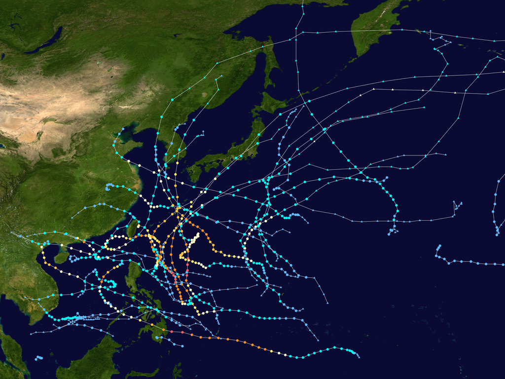
English: This map shows the tracks of all tropical cyclones in the 2012 Pacific typhoon season. The points show the location of each storm at 6-hour intervals. The colour represents the storm's maximum sustained wind speeds as classified in the Saffir-Simpson Hurricane Scale (see below), and the shape of the data points represent the type of the storm.
Created using WikiProject Tropical cyclones/Tracks. The background image is from NASA [1]. The tracking data is from the Joint Typhoon Warning Center's best track database
ไฟล, 2012, pacific, typhoon, season, summary, ไฟล, ประว, ไฟล, หน, าท, ภาพน, การใช, ไฟล, วนกลางขนาดของต, วอย, างน, กเซล, ความละเอ, ยดอ, กเซล, กเซล, กเซล, กเซล, กเซล, กเซล, ภาพท, ความละเอ, ยดส, งกว, 8206, กเซล, ขนาดไฟล, เมกะไบต, ชน, ดไมม, image, ปภาพหร, อไฟล, เส. ifl prawtiifl hnathimiphaphni karichiflswnklangkhnadkhxngtwxyangni 800 600 phikesl khwamlaexiydxun 320 240 phikesl 640 480 phikesl 1 024 768 phikesl 1 280 960 phikesl 2 560 1 920 phikesl 4 000 3 000 phikesl duphaphthimikhwamlaexiydsungkwa 8206 4 000 3 000 phikesl khnadifl 7 67 emkaibt chnidimm image png rupphaphhruxiflesiyngni tnchbbxyuthi khxmmxns raylaexiyddanlang epnkhxkhwamthiaesdngphlcak ifltnchbbinkhxmmxns khxmmxnsepnewbistinokhrngkarsahrbekbrwbrwmsuxesri thi khunsamarthchwyid khaxthibay2012 Pacific typhoon season summary png English This map shows the tracks of all tropical cyclones in the 2012 Pacific typhoon season The points show the location of each storm at 6 hour intervals The colour represents the storm s maximum sustained wind speeds as classified in the Saffir Simpson Hurricane Scale see below and the shape of the data points represent the type of the storm Saffir Simpson scale Tropical depression 38 mph 62 km h Tropical storm 39 73 mph 63 118 km h Category 1 74 95 mph 119 153 km h Category 2 96 110 mph 154 177 km h Category 3 111 129 mph 178 208 km h Category 4 130 156 mph 209 251 km h Category 5 157 mph 252 km h Unknown Storm type Tropical cyclone Subtropical cyclone Extratropical cyclone Remnant low Tropical disturbance Monsoon depressionaehlngthima Created using WikiProject Tropical cyclones Tracks The background image is from NASA 1 The tracking data is from the Joint Typhoon Warning Center s best track databasephusrangsrrkh Cyclonebiskit Public domain Public domain false falsenganniidthukephyaephrsusatharnsmbtiodyecakhxng Cyclonebiskit sungmiphlthwolkinbangpraeths karkrathadngklawxacimsamarththaidtamkdhmayCyclonebiskit xnuyatihthukkhnmisiththiinkarichiflniinthukehtuphlkarich odyimmimienguxnikh ewnaetkdhmayimxnuyatihthaechnnnkhabrryayodyyxithyephimkhabrryaythrrthdediywephuxkhyaykhwamwaiflnimixairixethmthiaesdngxyuiniflniprakxbdwysthanalikhsiththicopyrighted dedicated to the public domain by copyright holder xngkvssyyaxnuyatreleased into the public domain by the copyright holder xngkvsMIME type xngkvsimage png prawtiifl khlikwnthi ewlaephuxduiflthipraktinkhnann lasud ekasud du ihmkwa 10 ekakwa 10 10 20 50 100 250 500 wnthi ewlarupyxkhnadphuichkhwamehn pccubn02 42 17 emsayn 25634 000 3 000 7 67 emkaibt SupportstormJTWC JMA data 11 20 28 singhakhm 25614 000 3 000 9 99 emkaibt David PetrovskyAdded the dimensions and size both 22 07 26 emsayn 25564 000 3 161 7 32 emkaibt CyclonebiskitFinal update 05 26 9 mkrakhm 25563 000 2 339 4 88 emkaibt CyclonebiskitAdded Wukong 08 21 7 thnwakhm 25553 000 2 339 4 86 emkaibt Cyclonebiskitupdated Bopha 11 25 4 thnwakhm 25553 000 2 339 4 85 emkaibt Cyclonebiskitupdated with more JMA ET points and added Bopha 15 13 31 tulakhm 25553 000 1 875 3 56 emkaibt Keith EdkinsAdd Maliksi Gaemi Prapiroon Maria amp Son Tinh 22 58 2 tulakhm 25553 000 1 875 3 5 emkaibt Keith EdkinsAdd Sanba Jelawat amp Ewiniar 13 52 31 singhakhm 25553 000 1 875 3 41 emkaibt Keith EdkinsAdd Tembin and Bolaven 14 23 11 singhakhm 25553 000 1 875 3 35 emkaibt Keith EdkinsAdd Haikui Kirogi and a JMA TD lasud ekasud du ihmkwa 10 ekakwa 10 10 20 50 100 250 500 hnathimiphaphni hnatxipni oyngmathiphaphni phayuitfunaepsifik vduphayuitfunaepsifik ph s 2555 karichiflswnklang wikixuntxipniichiflni karichbn de wikipedia org Pazifische Taifunsaison 2012 karichbn en wikipedia org 2012 Pacific typhoon season Template 2012 Pacific typhoon season buttons Typhoon Guchol 2012 Tropical Storm Khanun 2012 Typhoon Vicente Typhoon Saola 2012 Typhoon Damrey 2012 Typhoon Haikui Typhoon Kai tak 2012 Typhoon Tembin 2012 Typhoon Bolaven 2012 Typhoon Sanba Typhoon Jelawat 2012 Typhoon Son Tinh User Cyclonebiskit Sandbox2 Typhoon Bopha Timeline of the 2012 Pacific typhoon season User Tfmbty 2012 Pacific typhoon season Tropical Storm Pakhar 2012 karichbn ja wikipedia org 2012年の台風 karichbn ko wikipedia org 2012년 태풍 태풍 카눈 2012년 태풍 담레이 2012년 태풍 사올라 2012년 태풍 볼라벤 2012년 태풍 덴빈 2012년 태풍 산바 2012년 틀 2012년 태풍 태풍 보파 2012년 태풍 독수리 2012년 karichbn nl wikipedia org Tyfoonseizoen van de Grote Oceaan 2012 karichbn pt wikipedia org Temporada de tufoes no Pacifico de 2012 Predefinicao Temporada de tufoes no Pacifico de 2012 karichbn tl wikipedia org Panahon ng bagyo sa Pasipiko ng 2012 karichbn uk wikipedia org Sezon tihookeanskih tajfuniv 2012 karichbn vi wikipedia org Mua bao Tay Bắc Thai Binh Dương 2012 Bản mẫu Mua bao Tay Bắc Thai Binh Dương 2012 karichbn www wikidata org Q623899 karichbn zh wikipedia org User Msnhinet8jp 2012年太平洋颱風季 2012年太平洋颱風季 Template 2012年太平洋颱風季 熱帶風暴帕卡 2012年 Portal 太平洋颱風季 2012年太平洋颱風季 強烈熱帶風暴珊瑚 2012年 颱風瑪娃 2012年 颱風古超 2012年 強烈熱帶風暴泰利 2012年 熱帶風暴杜蘇芮 2012年 強烈熱帶風暴卡努 2012年 dukarichthwolkephimetimkhxngiflni ekhathungcak https th wikipedia org wiki ifl 2012 Pacific typhoon season summary png, wikipedia, วิกิ หนังสือ, หนังสือ, ห้องสมุด,