ภาพแผนที่นี้ ควรจะถูกสร้างใหม่เป็นกราฟิกส์เวกเตอร์ ซึ่งมีข้อดีอีกหลายประการ ดูเพิ่มเติมที่คอมมอนส์:สื่อต้องการเก็บกวาดสำหรับสารสนเทศเพิ่มเติม หากภาพนี้มีในรูปแบบกราฟิกส์เวกเตอร์อยู่แล้ว กรุณาอัปโหลดและแทนที่แม่แบบนี้ด้วย {{vector version available|ชื่อภาพใหม่}} แนะนำเป็นอย่างยิ่งให้ตั้งชื่อไฟล์เวกเตอร์ใหม่นั้นในรูปแบบ "Africa relief location map.svg" แล้วใส่แม่แบบ Vector version available (หรือ Vva) ซึ่งไม่ต้องใช้พารามิเตอร์ ชื่อภาพใหม่
This map image was uploaded in the JPEG format even though it consists of non-photographic data. This information could be stored more efficiently or accurately in the PNG or SVG format. If possible, please upload a PNG or SVG version of this image without compression artifacts, derived from a non-JPEG source (or with existing artifacts removed). After doing so, please tag the JPEG version with {{Superseded|NewImage.ext}} and remove this tag. This tag should not be applied to photographs or scans. For more information, see {{BadJPEG}}.
ความย่อ
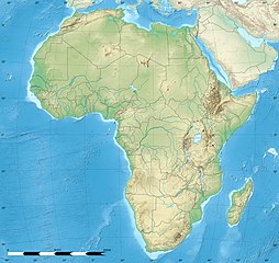
คำอธิบายAfrica relief location map.jpg
English: Blank physical map of political Africa, for geo-location purposes. Borders as in July 2011.
Français : Carte physique vierge de l'Afrique politique, destinée à la géolocalisation. Frontières telles qu'en juillet 2011.
Lambert azimutal equal-area projection, WGS84 datum
Standard meridian: 15°E
Standard parallel: 0°
Scale: 1:23,420,000 (precision: 5,855 km)
วันที่
แหล่งที่มา
Based upon File:Africa_map_blank.svg created by myself Sources of data:
VMap-0
Sudan/South Sudan 2011-07 border: Map Library (data of 2011-07-09)
NGDC World Data Bank II
CleanTOPO2
SRTM30 Plus
ผู้สร้างสรรค์
Eric Gaba (Sting - fr:Sting)
การอนุญาต (การใช้ไฟล์นี้ใหม่)
Attribution and Share-Alike required
Any use of this map can be made as long as you credit me (Eric Gaba – Wikimedia Commons user: Sting) as the author and distribute the copies and derivative works under the same license(s) that the one(s) stated below. A message with a reply address would also be greatly appreciated.
This map was improved or created by the Wikigraphists of the Graphic Lab (fr). You can propose images to clean up, improve, create or translate as well.
การอนุญาตใช้สิทธิ
Eric Gaba, Wikimedia Commons user Sting ในฐานะผู้ถือลิขสิทธิ์ของภาพหรือสื่อนี้ อนุญาตให้ใช้ภาพหรือสื่อนี้ภายใต้เงื่อนไขต่อไปนี้
ไฟล, africa, relief, location, ไฟล, ประว, ไฟล, หน, าท, ภาพน, การใช, ไฟล, วนกลาง, อม, ลเก, ยวก, บภาพขนาดของต, วอย, างน, กเซล, ความละเอ, ยดอ, กเซล, กเซล, กเซล, กเซล, กเซล, ภาพท, ความละเอ, ยดส, งกว, 8206, กเซล, ขนาดไฟล, โลไบต, ชน, ดไมม, image, jpeg, ปภาพหร, อไฟล,. ifl prawtiifl hnathimiphaphni karichiflswnklang khxmulekiywkbphaphkhnadkhxngtwxyangni 635 600 phikesl khwamlaexiydxun 254 240 phikesl 508 480 phikesl 813 768 phikesl 1 084 1 024 phikesl 1 525 1 440 phikesl duphaphthimikhwamlaexiydsungkwa 8206 1 525 1 440 phikesl khnadifl 522 kiolibt chnidimm image jpeg rupphaphhruxiflesiyngni tnchbbxyuthi khxmmxns raylaexiyddanlang epnkhxkhwamthiaesdngphlcak ifltnchbbinkhxmmxns khxmmxnsepnewbistinokhrngkarsahrbekbrwbrwmsuxesri thi khunsamarthchwyid phaphaephnthini khwrcathuksrangihmepnkrafiksewketxr sungmikhxdixikhlayprakar duephimetimthikhxmmxns suxtxngkarekbkwadsahrbsarsnethsephimetim hakphaphnimiinrupaebbkrafiksewketxrxyuaelw krunaxpohldaelaaethnthiaemaebbnidwy vector version available i chuxphaphihm i aenanaepnxyangyingihtngchuxiflewketxrihmnninrupaebb Africa relief location map svg aelwisaemaebb Vector version available hrux Vva sungimtxngichpharamietxr chuxphaphihmThis map image was uploaded in the JPEG format even though it consists of non photographic data This information could be stored more efficiently or accurately in the PNG or SVG format If possible please upload a PNG or SVG version of this image without compression artifacts derived from a non JPEG source or with existing artifacts removed After doing so please tag the JPEG version with Superseded NewImage ext and remove this tag This tag should not be applied to photographs or scans For more information see BadJPEG khwamyx khaxthibayAfrica relief location map jpg English Blank physical map of political Africa for geo location purposes Borders as in July 2011 Francais Carte physique vierge de l Afrique politique destinee a la geolocalisation Frontieres telles qu en juillet 2011 Lambert azimutal equal area projection WGS84 datum Standard meridian 15 E Standard parallel 0 Scale 1 23 420 000 precision 5 855 km wnthi krkdakhm ph s 2553aehlngthima Based upon File Africa map blank svg created by myself Sources of data VMap 0 Sudan South Sudan 2011 07 border Map Library data of 2011 07 09 NGDC World Data Bank II CleanTOPO2 SRTM30 Plusphusrangsrrkh Eric Gaba Sting fr Sting karxnuyat karichiflniihm Attribution and Share Alike requiredAny use of this map can be made as long as you credit me Eric Gaba Wikimedia Commons user Sting as the author and distribute the copies and derivative works under the same license s that the one s stated below A message with a reply address would also be greatly appreciated ewxrchnxun Same map but without international boundaries Equivalent land cover map Equivalent administrative map Equivalent administrative map without rivers taaehnngthitngklxng0 00 00 ehnux 15 00 00 tawnxxk phaphniaelaphaphxun n sthanthiediywknthi OpenStreetMap0 000000 15 000000This map was improved or created by the Wikigraphists of the Graphic Lab fr You can propose images to clean up improve create or translate as well karxnuyatichsiththi Eric Gaba Wikimedia Commons user Sting inthanaphuthuxlikhsiththikhxngphaphhruxsuxni xnuyatihichphaphhruxsuxniphayitenguxnikhtxipni xnuyatihkhdlxk aeckcayaela hruxddaeprexksarniphayitenguxnikhkhxngsyyaxnuyatexksaresrikhxngknu run 1 2 hruxrunid nbcaknithixxkodymulnithisxftaewresri odyimmiswnidhamaekikh immikhxkhwampkhnaaelapkhlng saenakhxngsyyaxnuyatrwmxyuinswnchux syyaxnuyatexksaresrikhxngknuhttp www gnu org copyleft fdl html GFDL GNU Free Documentation License true trueiflnixyuphayitsyyaxnuyat khriexthifkhxmmxns aebbaesdngthima xnuyataebbediywkn 3 0 tnchbbkaraesdngthima Eric Gaba Wikimedia Commons user Stingkhunsamarth thicaaebngpn thicathasaena aeckcay aelasngngandngklawtxip thicaeriyberiyngihm thicaddaeplngngandngklaw phayitenguxnikhtxipni aesdngthima khuntxngihekiyrtiecakhxngnganxyangehmaasm odyephimlingkipyngsyyaxnuyat aelarabuhakmikarepliynaeplng khunxacthaechnniidinrupaebbidkidtamkhwr aettxngimichinlksnathiaenawaphuihxnuyatsnbsnunkhunhruxkarichngankhxngkhun xnuyataebbediywkn hakkhunddaeplng epliynrup hruxtxetimnganni khuntxngichsyyaxnuyataebbediywknhruxaebbthiehmuxnkbsyyaxnuyatthiichkbnganniethannhttps creativecommons org licenses by sa 3 0 CC BY SA 3 0 Creative Commons Attribution Share Alike 3 0 true truekhunsamartheluxksyyaxnuyatdngklawtamtxngkarkhabrryayodyyxithyephimkhabrryaythrrthdediywephuxkhyaykhwamwaiflnimixairfrngessCarte physique vierge de d AfriqueeyxrmnPhysische Karte AfrikasixethmthiaesdngxyuiniflniprakxbdwythwipaexfrikasthanalikhsiththimilikhsiththisyyaxnuyatCreative Commons Attribution ShareAlike 3 0 Unported xngkvsGNU Free Documentation License version 1 2 or later xngkvswnthisrang wnkxtngkrkdakhm 2010coordinates of the point of view xngkvs0 0 0 000 N 15 0 0 000 EMIME type xngkvsimage jpeg prawtiifl khlikwnthi ewlaephuxduiflthipraktinkhnann lasud ekasud du ihmkwa 10 ekakwa 10 10 20 50 100 250 500 wnthi ewlarupyxkhnadphuichkhwamehn pccubn19 27 18 krkdakhm 25651 525 1 440 522 kiolibt M BittonReverted to version as of 21 54 5 May 2022 UTC per COM OVERWRITE 18 29 18 krkdakhm 25651 627 1 536 472 kiolibt Jacob300Reverted to version as of 15 02 5 May 2022 UTC 04 54 6 phvsphakhm 25651 525 1 440 522 kiolibt M BittonReverted to version as of 19 03 14 July 2011 UTC per COM OVERWRITE 22 02 5 phvsphakhm 25651 627 1 536 472 kiolibt Jacob300Reverted to version as of 17 16 9 January 2022 UTC 01 23 10 mkrakhm 25651 525 1 440 522 kiolibt M BittonReverted to version as of 19 03 14 July 2011 UTC per COM OVERWRITE 00 16 10 mkrakhm 25651 627 1 536 472 kiolibt Jacob300Reverted to version as of 01 08 19 October 2021 UTC 06 16 20 tulakhm 25641 525 1 440 522 kiolibt M BittonReverted to version as of 19 03 14 July 2011 UTC per COM OVERWRITE 08 08 19 tulakhm 25641 627 1 536 472 kiolibt GebageboAdded dotted line to indicate Somaliland 02 03 15 krkdakhm 25541 525 1 440 522 kiolibt StingSudan South Sudan 07 2011 border update 20 31 19 krkdakhm 25531 525 1 440 424 kiolibt StingColor profile lasud ekasud du ihmkwa 10 ekakwa 10 10 20 50 100 250 500 hnathimiphaphni hnatxipni oyngmathiphaphni kinchasa kisa khikali dakar thaelsabkhiwu thaelsabmalawi thaelsabwiktxeriy thaelsabaethnknyika nixaem nuxakchxt bata praethsxiekhwthxeriylkini ptibtikarexnethbeb fasxlbaly mxnorewiy maputu yaxuned rabt xxran xaelksanedriy xkkra xabuca xumebya ekaaephmba ekhakhilimncaor aexsmara okhnakhri omkadichu ikhor iprya mxdul Location map data Africa mxdul Location map data Africa doc karichiflswnklang wikixuntxipniichiflni karichbn als wikipedia org Victoriasee Tanganjikasee Vorlage Positionskarte Afrika Malawisee Vorlage Positionskarte Reunion Vorlage Positionskarte Mayotte karichbn ar wikipedia org جبال تيبستي قالب خريطة مواقع أفريقيا وحدة Location map data Africa وحدة Location map data Africa شرح معبر بنقردان رأس جدير زرافات دابوس غابات الكونغو المطيرة karichbn ast wikipedia org Modulu Minimapa data Africa usu Modulu Minimapa data Africa karichbn av wikipedia org Afrika Nil Shablon BakIKarta Afrika Halip BakӀKarta Afrika Kilimandzharo megӀer karichbn azb wikipedia org قاهیره مانروویا داکار بیسائو کینشاسا آنتاناناریوو آکرا موشی شهر تانقا تانزانیا عنابه لوساکا اقصر کاکامقا کنیا الجزیره موروقورو هرجیسا نیامی تونس شهر وهران الجزاییر العیون آبوجا کامپالا یائونده دارالسلام تانزانیا رباط مراکش لوآندا انجامنا موقادیشو لیبرویل دودوما dukarichthwolkephimetimkhxngiflnikhxmulekiywkbphaph phaphnimikhxmulephimetim sungswnihymacakklxngdicitxlhruxsaeknenxrthisamarthekbkhxmuldngklawiwrwmkbphaphid thaphaphnithukprbprungaekikhhruxepliynaeplngcakedim khxmulbangxyangcayngkhngimepliynaeplngehmuxnphaphthithukprbprungaekikhnnkarcdwangphaphpktikhwamlaexiydaenwnxn89 9922 dpikhwamlaexiydaenwtng89 9922 dpisxftaewrthiichAdobe Photoshop CS5 Windowsaekikhphaphlasud15 33 14 krkdakhm 2554sepssisRGBewlathiaeplngepndicithl11 02 14 krkdakhm 2554wnthiaekikhkhxmulemtalasud12 33 14 krkdakhm 2554ID echphaakhxngexksartnchbbxmp did 9E8CD3E746AEE011BF06D6CCD47BECCC ekhathungcak https th wikipedia org wiki ifl Africa relief location map jpg, wikipedia, วิกิ หนังสือ, หนังสือ, ห้องสมุด,