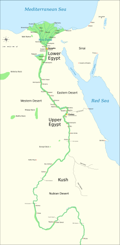
English: Map of Ancient Egypt, showing the Nile up to the fifth cataract, and major cities and sites of the Dynastic period (c. 3150 BC to 30 BC). Cairo and Jerusalem are shown as reference cities.
วันที่
แหล่งที่มา
Own work using:
Shaw, Ian , ed. (พ.ศ. 2546) The Oxford History of Ancient Egypt, Oxford University Press ISBN: 0-19-280293-3.
Dr. Peter Der Manuelian , ed. (พ.ศ. 2541) Egypt: The World of the Pharaohs, Bonner Straße, Köln (Deutschland): Könemann Verlagsgesellschaft mbH ISBN: 3-89508-913-3.
This file is licensed under the Creative Commons Attribution-Share Alike 4.0 International, 3.0 Unported, 2.5 Generic, 2.0 Generic and 1.0 Generic license.
2007-11-27 23:32 Jeff Dahl 1577×3219×0 (391000 bytes) (Minor adjustments to Naukratis and Buto)
2007-11-27 18:59 Jeff Dahl 1577×3219×0 (391000 bytes) (Cairo and Jerusalem now with black dots/italics)
2007-11-23 00:04 Jeff Dahl 1577×3219×0 (391000 bytes) (fx scalebar)
2007-11-22 23:56 Jeff Dahl 1577×3219×0 (391000 bytes) ({{Information |Description=A map of ancient Egypt, made with Inkscape |Source=self-made |Date=11-22-07 |Author= Jeff Dahl |Permission= |other_versions={{DerivativeVersions|Ancient Egypt map-ru.svg}} }} )
{{Assessments|1=Ancient Egypt map.svg|enwiki=1}} __NOTOC__ == {{int:filedesc}} == {{inkscape}} {{Information |Description= {{en|Map of Ancient Egypt, showing the Nile up to the fifth cataract, and major cities and sites of the Dynastic period (c. 3150 BC
ไฟล, ancient, egypt, ไฟล, ประว, ไฟล, หน, าท, ภาพน, การใช, ไฟล, วนกลาง, อม, ลเก, ยวก, บภาพขนาดของต, วอย, าง, ของไฟล, กเซล, ความละเอ, ยดอ, กเซล, กเซล, กเซล, กเซล, กเซล, กเซล, ภาพท, ความละเอ, ยดส, งกว, 8206, ไฟล, กเซล, ขนาดไฟล, โลไบต, ปภาพหร, อไฟล, เส, ยงน, นฉบ, . ifl prawtiifl hnathimiphaphni karichiflswnklang khxmulekiywkbphaphkhnadkhxngtwxyang PNG nikhxngifl SVG ni 293 598 phikesl khwamlaexiydxun 117 240 phikesl 235 480 phikesl 376 768 phikesl 501 1 024 phikesl 1 003 2 048 phikesl 1 577 3 219 phikesl duphaphthimikhwamlaexiydsungkwa 8206 ifl SVG 1 577 3 219 phikesl khnadifl 626 kiolibt rupphaphhruxiflesiyngni tnchbbxyuthi khxmmxns raylaexiyddanlang epnkhxkhwamthiaesdngphlcak ifltnchbbinkhxmmxns khxmmxnsepnewbistinokhrngkarsahrbekbrwbrwmsuxesri thi khunsamarthchwyid nbsp nikhuxphaphkhdsrrinwikiphiediyphasaxngkvs Featured pictures aela khux thuxwaepn phaphxyangidxyanghnungthidithisud thakhidwaiflnikhwrcaihkhwamsakhykbwikimiediykhxmmxnsepnxyangdi xyalngelthica esnxchux hakkhunmiphaphthimikhunphaph khlaykhlungkn thicasamarthephyaephridtam syyaxnuyatthiehmaasm ihaenicwa khunid xpohld kahndsyyaxnuyat aelaid esnxchuxaelw khwamyx nbsp iflphaphkrafiksewketxrimidrabukartrwcody W3C nbsp ni srangkhunodyich nbsp Inkscape khaxthibayAncient Egypt map en svg English Map of Ancient Egypt showing the Nile up to the fifth cataract and major cities and sites of the Dynastic period c 3150 BC to 30 BC Cairo and Jerusalem are shown as reference cities wnthi 22 phvscikayn ph s 2550 aehlngthima Own work using Shaw Ian ed ph s 2546 The Oxford History of Ancient Egypt Oxford University Press ISBN 0 19 280293 3 Dr Peter Der Manuelian ed ph s 2541 Egypt The World of the Pharaohs Bonner Strasse Koln Deutschland Konemann Verlagsgesellschaft mbH ISBN 3 89508 913 3 Digital Egypt maps Retrieved on 2007 11 25 NASA PIA04957 Retrieved on 2007 11 25 NASA PIA02647 Retrieved on 2007 11 25 NASA PIA04965 Retrieved on 2007 11 25 Coordinates Sais 30 57 53 N 30 46 6 E Buto 31 11 47 N 30 44 41 E Alexandria 31 11 53 N 29 55 09 E Naukratis 30 54 N 30 35 E coordinates here Tanis 30 58 37 N 31 52 48 E Avaris 30 47 N 31 50 E Busiris 30 54 40 N 31 14 40 E Image renamed from File Ancient Egypt map svg see Original upload log phusrangsrrkh Jeff Dahl ewxrchnxun aekikh Afrikaans Deutsch eesti PNG English espanol Esperanto JPG Esperanto JPG 2 euskara francais italiano Latina Nederlands norsk polski portugues slovencina Tiếng Việt Turkce PNG makedonski russkij srpski ћirilica Ellhnika 中文 简体 العربية PNG English ihexxorklifxiyipt ifl SVG nimikhxkhwamthisamarthaeplid odyichekhruxngmuxaepbphasa SVG hruxichtwaekikh SVG idkid sahrbkhxmulephimetim duthiekiywkbkaraeplifl karxnuyatichsiththi khapheca inthanaphuthuxlikhsiththikhxngphaphhruxsuxni xnuyatihichphaphhruxsuxniphayitenguxnikhtxipni xnuyatihkhdlxk aeckcayaela hruxddaeprexksarniphayitenguxnikhkhxngsyyaxnuyatexksaresrikhxngknu run 1 2 hruxrunid nbcaknithixxkodymulnithisxftaewresri odyimmiswnidhamaekikh immikhxkhwampkhnaaelapkhlng saenakhxngsyyaxnuyatrwmxyuinswnchux syyaxnuyatexksaresrikhxngknuhttp www gnu org copyleft fdl html GFDL GNU Free Documentation License true trueThis file is licensed under the Creative Commons Attribution Share Alike 4 0 International 3 0 Unported 2 5 Generic 2 0 Generic and 1 0 Generic license khunsamarth thicaaebngpn thicathasaena aeckcay aelasngngandngklawtxip thicaeriyberiyngihm thicaddaeplngngandngklaw phayitenguxnikhtxipni aesdngthima khuntxngihekiyrtiecakhxngnganxyangehmaasm odyephimlingkipyngsyyaxnuyat aelarabuhakmikarepliynaeplng khunxacthaechnniidinrupaebbidkidtamkhwr aettxngimichinlksnathiaenawaphuihxnuyatsnbsnunkhunhruxkarichngankhxngkhun xnuyataebbediywkn hakkhunddaeplng epliynrup hruxtxetimnganni khuntxngichsyyaxnuyataebbediywknhruxaebbthiehmuxnkbsyyaxnuyatthiichkbnganniethannhttps creativecommons org licenses by sa 4 0 CC BY SA 4 0 Creative Commons Attribution Share Alike 4 0 true truekhunsamartheluxksyyaxnuyatdngklawtamtxngkar bnthukkarxphohld The original description page is was here All following user names refer to Commons 2009 01 29 13 21 Bibi Saint Pol 1577 3219 0 412000 bytes remove wrong text adjust frame 2009 01 29 12 47 Bibi Saint Pol 1577 3219 0 413000 bytes added frame 2009 01 29 12 35 Bibi Saint Pol 1577 3219 0 412000 bytes harmonize colors with the standards replace unsupported Arial fonts by DejaVu 2008 02 11 06 55 Jeff Dahl 1577 3219 0 391000 bytes sp fx 2007 11 29 02 09 Jeff Dahl 1577 3219 0 391000 bytes Rotate Mediterranean Sea label 2007 11 27 23 32 Jeff Dahl 1577 3219 0 391000 bytes Minor adjustments to Naukratis and Buto 2007 11 27 18 59 Jeff Dahl 1577 3219 0 391000 bytes Cairo and Jerusalem now with black dots italics 2007 11 23 00 04 Jeff Dahl 1577 3219 0 391000 bytes fx scalebar 2007 11 22 23 56 Jeff Dahl 1577 3219 0 391000 bytes Information Description A map of ancient Egypt made with Inkscape Source self made Date 11 22 07 Author Jeff Dahl Permission other versions DerivativeVersions Ancient Egypt map ru svg khabrryayodyyxithyephimkhabrryaythrrthdediywephuxkhyaykhwamwaiflnimixairxngkvsAncient Egypt c 3150 BC to 30 BC ixethmthiaesdngxyuiniflniprakxbdwyphusrangbangkhathiimmiixethmwikisnethshnathikhxngwtthuphayitpraphcnni changphaphchuxphuichwikimiediy Jeff Dahlyuxaraexl https commons wikimedia org wiki user Jeff Dahlchuxphusrangsrrkh Jeff DahlsthanalikhsiththimilikhsiththisyyaxnuyatCreative Commons Attribution ShareAlike 2 5 Generic nbsp xngkvsCreative Commons Attribution ShareAlike 4 0 International nbsp xngkvsCreative Commons Attribution ShareAlike 2 0 Generic nbsp xngkvsGNU Free Documentation License version 1 2 or lateral nbsp xngkvsCreative Commons Attribution ShareAlike 1 0 Generic nbsp xngkvsCreative Commons Attribution ShareAlike 3 0 Unported nbsp xngkvswnthisrang wnkxtng22 phvscikayn 2007MIME type nbsp xngkvsimage svg xml prawtiifl khlikwnthi ewlaephuxduiflthipraktinkhnann wnthi ewlarupyxkhnadphuichkhwamehn pccubn06 56 18 minakhm 25651 577 3 219 626 kiolibt ManlleusFile uploaded using svgtranslate tool https svgtranslate toolforge org Added translation for ca 22 23 6 minakhm 25651 577 3 219 564 kiolibt ScratchingheadFile uploaded using svgtranslate tool https svgtranslate toolforge org Added translation for ta 13 03 25 kumphaphnth 25651 577 3 219 564 kiolibt ScratchingheadFile uploaded using svgtranslate tool https svgtranslate toolforge org Added translation for ta 02 29 7 minakhm 25631 577 3 219 501 kiolibt Nilesh shuklaFile uploaded using svgtranslate tool https tools wmflabs org svgtranslate Added translation for hi 18 28 20 kumphaphnth 25521 577 3 219 413 kiolibt Bibi Saint Polfix translation mistake on the windrose 19 13 30 mkrakhm 25521 577 3 219 413 kiolibt Bibi Saint Polfix position of Nile Delta 19 21 29 mkrakhm 25521 577 3 219 412 kiolibt Bibi Saint Polremove wrong text adjust frame 19 05 29 mkrakhm 25521 577 3 219 413 kiolibt Bibi Saint Pol Assessments 1 Ancient Egypt map svg enwiki 1 NOTOC int filedesc inkscape Information Description en Map of Ancient Egypt showing the Nile up to the fifth cataract and major cities and sites of the Dynastic period c 3150 BC hnathimiphaphni hnatxipni oyngmathiphaphni rachxanackrekaaehngxiyipt smyrahwangklangthihnungaehngxiyipt smaphnththinis xiyiptobran karichiflswnklang wikixuntxipniichiflni karichbn anp wikipedia org प र च न म स र karichbn azb wikipedia org هخامنشیلر دؤولتی اسکی میصر میصر اسکی کراللیغی karichbn blk wikipedia org အ ဂ စ ပ င လ င စခ karichbn bn wikipedia org ম শর য সভ যত হ খম ন শ স ম র জ য প র তন র জত ব ম শর ন ব য karichbn bs wikipedia org Ahemenidsko Carstvo Donji Egipat Gornji Egipat karichbn ca wikipedia org Antic Egipte Imperi Aquemenida karichbn ceb wikipedia org Idris karichbn ckb wikipedia org میسری کۆن karichbn cs wikipedia org Staroveky Egypt Stara rise Prvni prechodna doba karichbn cv wikipedia org Avalhi patshalӑh karichbn da wikipedia org Achaemenidiske rige Ovre Egypten karichbn en wikipedia org Ancient Egypt Jean Francois Champollion Old Kingdom of Egypt First Intermediate Period of Egypt 671 BC Wikipedia WikiProject Former countries Cradle of civilization Portal Africa Featured article Portal Africa Featured picture Portal Ancient Egypt Buhen Portal Ancient Egypt Selected picture Portal talk Africa Featured picture Portal Maps Selected picture Thinite Confederacy Portal Egypt Portal Egypt Selected picture Portal Africa Featured article 2 Wikipedia Featured pictures thumbs 09 Wikipedia Picture peer review Ancient Egypt main map Wikipedia Featured picture candidates November 2007 Wikipedia Featured picture candidates Ancient Egypt map en svg Wikipedia Wikipedia Signpost 2007 12 03 Features and admins Portal Africa Featured picture 22 Portal Maps Selected picture 32 User talk Jeff Dahl Archive 2 Portal Ancient Egypt Selected picture 2 User talk Jeff Dahl Archive 3 dukarichthwolkephimetimkhxngiflnikhxmulekiywkbphaph phaphnimikhxmulephimetim sungswnihymacakklxngdicitxlhruxsaeknenxrthisamarthekbkhxmuldngklawiwrwmkbphaphid thaphaphnithukprbprungaekikhhruxepliynaeplngcakedim khxmulbangxyangcayngkhngimepliynaeplngehmuxnphaphthithukprbprungaekikhnnkhwamkwang1577 348khwamsung3219 4182 ekhathungcak https th wikipedia org wiki ifl Ancient Egypt map en svg, wikipedia, วิกิ หนังสือ, หนังสือ, ห้องสมุด,