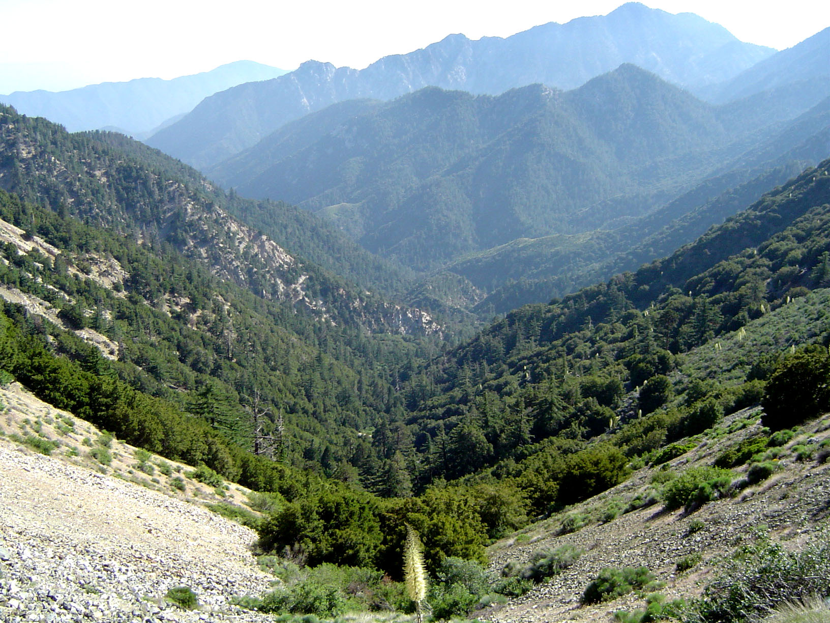
English: The San Gabriel Mountains, part of the Angeles National Forest in Los Angeles County, California.
Twin Peaks (7761 feet) is in the middle distance on the right. Monrovia Peak (5409 feet) is in the far distance on the right.
Taken from Islip Saddle (6600 feet) looking southwest down Bear Creek, a tributary of the San Gabriel River that lies within the San Gabriel Wilderness.
https://creativecommons.org/licenses/by/1.0CC BY 1.0 Creative Commons Attribution 1.0 truetrue
บันทึกการอัพโหลด
The original description page was here. All following user names refer to en.wikipedia.
2005-06-27 02:40 Geographer 1632×1224× (535148 bytes) Photographed and uploaded by user:Geographer. Angeles National Forest at about 6500 feet looking toward Los Angeles, June 25, 2005 {{Cc-by-1.0}}
{{BotMoveToCommons|en.wikipedia|year={{subst:CURRENTYEAR}}|month={{subst:CURRENTMONTHNAME}}|day={{subst:CURRENTDAY}}}} {{Information |Description={{en|Photographed and uploaded by user:Geographer. The San Gabriel Mountains, part of the Angeles National
ไฟล, angelesnationalforest, ไฟล, ประว, ไฟล, หน, าท, ภาพน, การใช, ไฟล, วนกลาง, อม, ลเก, ยวก, บภาพขนาดของต, วอย, างน, กเซล, ความละเอ, ยดอ, กเซล, กเซล, กเซล, กเซล, กเซล, ภาพท, ความละเอ, ยดส, งกว, 8206, กเซล, ขนาดไฟล, โลไบต, ชน, ดไมม, image, jpeg, ปภาพหร, อไฟล, เส. ifl prawtiifl hnathimiphaphni karichiflswnklang khxmulekiywkbphaphkhnadkhxngtwxyangni 800 600 phikesl khwamlaexiydxun 320 240 phikesl 640 480 phikesl 1 024 768 phikesl 1 280 960 phikesl 1 632 1 224 phikesl duphaphthimikhwamlaexiydsungkwa 8206 1 632 1 224 phikesl khnadifl 523 kiolibt chnidimm image jpeg rupphaphhruxiflesiyngni tnchbbxyuthi khxmmxns raylaexiyddanlang epnkhxkhwamthiaesdngphlcak ifltnchbbinkhxmmxns khxmmxnsepnewbistinokhrngkarsahrbekbrwbrwmsuxesri thi khunsamarthchwyid khwamyx khaxthibayAngelesnationalforest jpg English The San Gabriel Mountains part of the Angeles National Forest in Los Angeles County California Twin Peaks 7761 feet is in the middle distance on the right Monrovia Peak 5409 feet is in the far distance on the right Taken from Islip Saddle 6600 feet looking southwest down Bear Creek a tributary of the San Gabriel River that lies within the San Gabriel Wilderness wnthi 25 mithunayn ph s 2548 27 mithunayn ph s 2548 original upload date aehlngthima naekhacak en wikipedia mayngkhxmmxns ody IngerAlHaosului odyich CommonsHelper phusrangsrrkh Geographer at en wikipedia karxnuyat karichiflniihm CC BY karxnuyatichsiththi iflnixyuphayitsyyaxnuyatkhriexthifkhxmmxns run aesdngthima 1 0 thwipkhunsamarth thicaaebngpn thicathasaena aeckcay aelasngngandngklawtxip thicaeriyberiyngihm thicaddaeplngngandngklaw phayitenguxnikhtxipni aesdngthima khuntxngihekiyrtiecakhxngnganxyangehmaasm odyephimlingkipyngsyyaxnuyat aelarabuhakmikarepliynaeplng khunxacthaechnniidinrupaebbidkidtamkhwr aettxngimichinlksnathiaenawaphuihxnuyatsnbsnunkhunhruxkarichngankhxngkhunhttps creativecommons org licenses by 1 0 CC BY 1 0 Creative Commons Attribution 1 0 true true bnthukkarxphohld The original description page was here All following user names refer to en wikipedia 2005 06 27 02 40 Geographer 1632 1224 535148 bytes Photographed and uploaded by user Geographer Angeles National Forest at about 6500 feet looking toward Los Angeles June 25 2005 Cc by 1 0 khabrryayodyyxithyephimkhabrryaythrrthdediywephuxkhyaykhwamwaiflnimixairixethmthiaesdngxyuiniflniprakxbdwysthanalikhsiththimilikhsiththisyyaxnuyatCreative Commons Attribution 1 0 Generic nbsp xngkvswnthisrang wnkxtng25 mithunayn 2005exposure time nbsp xngkvs0 004 winathif number nbsp xngkvs5 6focal length nbsp xngkvs6 milliemtrISO speed nbsp xngkvs100MIME type nbsp xngkvsimage jpegepnphaphthay prawtiifl khlikwnthi ewlaephuxduiflthipraktinkhnann wnthi ewlarupyxkhnadphuichkhwamehn pccubn16 17 14 mkrakhm 25531 632 1 224 523 kiolibt File Upload Bot Magnus Manske BotMoveToCommons en wikipedia year subst CURRENTYEAR month subst CURRENTMONTHNAME day subst CURRENTDAY Information Description en Photographed and uploaded by user Geographer The San Gabriel Mountains part of the Angeles National hnathimiphaphni hnatxipni oyngmathiphaphni ethsmnthllxsaexneclis karichiflswnklang wikixuntxipniichiflni karichbn ar wikipedia org قائمة الغابات الوطنية للولايات المتحدة karichbn arz wikipedia org غابة انجيليس الوطنيه ليستة غابات العالم karichbn ca wikipedia org Bosc Nacional Angeles Llista de boscos nacionals dels Estats Units karichbn ceb wikipedia org Angeles National Forest karichbn de wikipedia org Angeles National Forest karichbn en wikipedia org List of national forests of the United States Angeles National Forest San Gabriel River California Portal Greater Los Angeles Portal Greater Los Angeles L A Districts California montane chaparral and woodlands Geography of southern California California Historical Landmarks in Los Angeles County Wikipedia WikiProject U S counties Guideline karichbn en wikivoyage org San Gabriel Valley Santa Clarita Valley karichbn es wikipedia org Anexo Bosques del sistema nacional de bosques de los Estados Unidos Bosque nacional de Angeles karichbn fa wikipedia org جنگل ملی انجلیز karichbn fr wikipedia org Foret nationale d Angeles Province floristique de Californie Chaparral et forets claires d altitude de Californie karichbn he wikivoyage org עמק סנטה קלריטה מחוז לוס אנג לס karichbn it wikipedia org Foreste nazionali degli Stati Uniti d America karichbn ml wikipedia org ല സ ആഞ ച ല സ ക ണ ട ആഞ ചലസ ദ ശ യ വന karichbn nl wikipedia org Angeles National Forest karichbn pl wikipedia org Rooster Portal Wielkie Los Angeles Portal Wielkie Los Angeles Regiony miasta i dzielnice karichbn simple wikipedia org Los Angeles County California karichbn www wikidata org Q3079095 karichbn zh wikipedia org 安琪拉国家森林 美国国家森林列表khxmulekiywkbphaph phaphnimikhxmulephimetim sungswnihymacakklxngdicitxlhruxsaeknenxrthisamarthekbkhxmuldngklawiwrwmkbphaphid thaphaphnithukprbprungaekikhhruxepliynaeplngcakedim khxmulbangxyangcayngkhngimepliynaeplngehmuxnphaphthithukprbprungaekikhnnphuphlitklxngSONYrunkhxngklxngDSC P72ewlaepidhnaklxng1 250 winathi 0 004 khaexff 5 6xtrakhwamerw ISO100ewlathibnthukphaph15 58 25 mithunayn 2548khwamyawofkselns6 mm karcdwangphaphpktikhwamlaexiydaenwnxn72 dpikhwamlaexiydaenwtng72 dpisxftaewrthiichAdobe Photoshop CS Windowsaekikhphaphlasud19 24 26 mithunayn 2548taaehnng Y aela CCo sitedopraekrmexksophechxropraekrmpktirunexksif Exif 2 2ewlathiaeplngepndicithl15 58 25 mithunayn 2548ohmdkarbibxdphaph4karchdechyaesng0rurbaesngkwangsud3 APEX f 2 83 ohmdkarwdaesngaephtethirnaesngimthrabaeflchimichaeflchsepssisRGBkarpramwlphaphophlessspktiohmdexksophechxrexksophechxrxtonmtiiwtbalansiwtbalansxtonmtichnidsinaekhpecxrpkti ekhathungcak https th wikipedia org wiki ifl Angelesnationalforest jpg, wikipedia, วิกิ หนังสือ, หนังสือ, ห้องสมุด,