คำอธิบายAntarctica, New Zealand territorial claim.svg
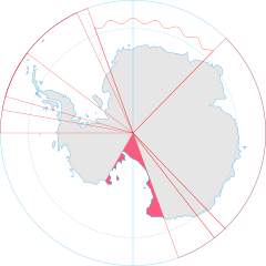
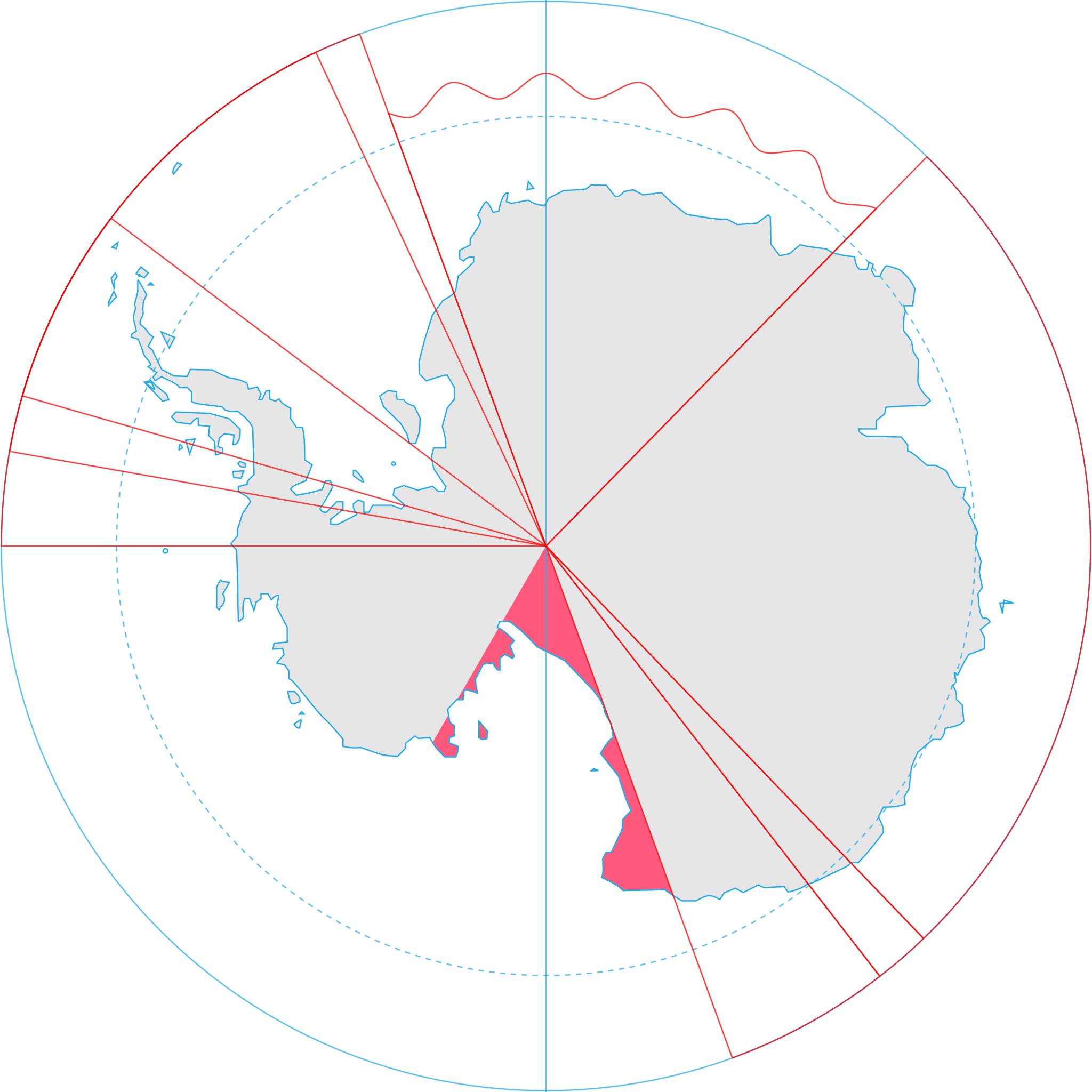
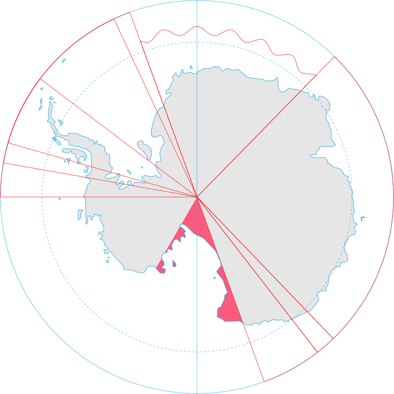
English: Map showing the territorial claim to Antarctica by the country in the filename. Also on the map are is the 60° S Parallel, Antarctic Circle, 0/180 latitude line and (in red) the borders of the claims by other states.
{{Information |Description={{en|Map showing the territorial claim to Antarctica by the country in the filename. Also on the map are is the 60° S Parallel, Antarctic Circle, 0/180 latitude line and (in red) the borders of the claims by other states.}} |So
ไฟล, antarctica, zealand, territorial, claim, ไฟล, ประว, ไฟล, หน, าท, ภาพน, การใช, ไฟล, วนกลาง, อม, ลเก, ยวก, บภาพขนาดของต, วอย, าง, ของไฟล, กเซล, ความละเอ, ยดอ, กเซล, กเซล, กเซล, กเซล, กเซล, กเซล, ภาพท, ความละเอ, ยดส, งกว, 8206, ไฟล, กเซล, ขนาดไฟล, โลไบต, ปภา. ifl prawtiifl hnathimiphaphni karichiflswnklang khxmulekiywkbphaphkhnadkhxngtwxyang PNG nikhxngifl SVG ni 600 600 phikesl khwamlaexiydxun 240 240 phikesl 480 480 phikesl 768 768 phikesl 1 024 1 024 phikesl 2 048 2 048 phikesl 806 806 phikesl duphaphthimikhwamlaexiydsungkwa 8206 ifl SVG 806 806 phikesl khnadifl 63 kiolibt rupphaphhruxiflesiyngni tnchbbxyuthi khxmmxns raylaexiyddanlang epnkhxkhwamthiaesdngphlcak ifltnchbbinkhxmmxns khxmmxnsepnewbistinokhrngkarsahrbekbrwbrwmsuxesri thi khunsamarthchwyid khaxthibayAntarctica New Zealand territorial claim svg English Map showing the territorial claim to Antarctica by the country in the filename Also on the map are is the 60 S Parallel Antarctic Circle 0 180 latitude line and in red the borders of the claims by other states wnthi 30 mithunayn ph s 2551 aehlngthima Generated from Antarctica by Lokal Profil phusrangsrrkh Lokal Profil karxnuyat karichiflniihm iflnixyuphayitsyyaxnuyat khriexthifkhxmmxns aebbaesdngthima xnuyataebbediywkn 2 5 thwipkaraesdngthima Lokal Profilkhunsamarth thicaaebngpn thicathasaena aeckcay aelasngngandngklawtxip thicaeriyberiyngihm thicaddaeplngngandngklaw phayitenguxnikhtxipni aesdngthima khuntxngihekiyrtiecakhxngnganxyangehmaasm odyephimlingkipyngsyyaxnuyat aelarabuhakmikarepliynaeplng khunxacthaechnniidinrupaebbidkidtamkhwr aettxngimichinlksnathiaenawaphuihxnuyatsnbsnunkhunhruxkarichngankhxngkhun xnuyataebbediywkn hakkhunddaeplng epliynrup hruxtxetimnganni khuntxngichsyyaxnuyataebbediywknhruxaebbthiehmuxnkbsyyaxnuyatthiichkbnganniethannhttps creativecommons org licenses by sa 2 5 CC BY SA 2 5 Creative Commons Attribution Share Alike 2 5 true true ewxrchnxun Ross Dependency orthographic projection mapkhabrryayodyyxithyephimkhabrryaythrrthdediywephuxkhyaykhwamwaiflnimixairturkiAntarktika Yeni Zelanda bolgesel hak iddiasiixethmthiaesdngxyuiniflniprakxbdwyphusrangbangkhathiimmiixethmwikisnethschuxphuichwikimiediy Lokal Profilyuxaraexl https commons wikimedia org wiki user Lokal Profilchuxphusrangsrrkh Lokal ProfilsthanalikhsiththimilikhsiththisyyaxnuyatCreative Commons Attribution ShareAlike 2 5 Generic nbsp xngkvswnthisrang wnkxtng30 mithunayn 2008MIME type nbsp xngkvsimage svg xmlchecksum nbsp xngkvsfca1f454f22342c54ad68e81cac16f3a7aa7dcabwithikarkahnd SHA 1 nbsp xngkvsdata size nbsp xngkvs64 807 ibtkhwamsung806 phikeslkhwamkwang806 phikesl prawtiifl khlikwnthi ewlaephuxduiflthipraktinkhnann wnthi ewlarupyxkhnadphuichkhwamehn pccubn00 09 9 phvsphakhm 2563806 806 63 kiolibt Spesh531Norway 039 s claim extends south to the South Pole as of June 12 2015 Northern claim is still undefined 03 55 1 krkdakhm 2551806 806 65 kiolibt Lokal Profil Information Description en Map showing the territorial claim to Antarctica by the country in the filename Also on the map are is the 60 S Parallel Antarctic Circle 0 180 latitude line and in red the borders of the claims by other states So hnathimiphaphni hnatxipni oyngmathiphaphni thwipaexntarktika rxssdiephnednsi karichiflswnklang wikixuntxipniichiflni karichbn af wikipedia org Ross Afhanklikheid karichbn an wikipedia org Dependencia de Ross karichbn ar wikipedia org القارة القطبية الجنوبية المطالب الإقليمية بالقارة القطبية الجنوبية الجدول الزمني لصلات نيوزيلندا مع القارة القطبية الجنوبية معهد أنتاركتيكا نيوزيلندا karichbn az wikipedia org Antarktida karichbn ca wikipedia org Antartida Reclamacions territorials a l Antartida karichbn chr wikipedia org ᏧᏁᏍᏓᎸ karichbn ckb wikipedia org دەروازە ئانتارکتیکا دەروازە ئانتارکتیکا ئاڵاکانی وڵاتانی پشکدار ١ karichbn cs wikipedia org Rossova dependence Uzemni naroky na Antarktidu karichbn de wikipedia org Politischer Status der Antarktis karichbn diq wikipedia org Antarktika Sablon Erde Antarktika karichbn el wikipedia org Antarktikh karichbn en wikipedia org Ross Dependency Timeline of New Zealand s links with Antarctica Antarctica New Zealand Territorial claims in Antarctica Wikipedia Graphics Lab Image workshop Archive Aug 2008 Antarctica User Kanevt1113 sandbox User HN016AQ sandbox karichbn es wikipedia org Antarctica New Zealand karichbn et wikipedia org Antarktis karichbn fa wikipedia org جنوبگان سیستم پیمان جنوبگان قلمرو وابسته راس ادعاهای ارضی در جنوبگان karichbn fi wikipedia org Etelamanner karichbn frr wikipedia org Antarktikaa karichbn fr wikipedia org Chronologie neo zelandaise de l Antarctique Antarctique karichbn gl wikipedia org Antartida karichbn gv wikipedia org Yn Antarctagh karichbn hi wikipedia org र स अध नक ष त र karichbn hu wikipedia org Az Antarktisz teruletei Antarktisz egyezmeny karichbn id wikipedia org Antarktika Pengeklaiman wilayah teritori di Antarktika karichbn ilo wikipedia org Dagiti panagtunton ti teritorio ti Antartika karichbn it wikipedia org Rivendicazioni territoriali in Antartide karichbn ja wikipedia org ロス海属領 南極における領有権主張の一覧 karichbn ko wikipedia org 남극의 영유권 주장 목록 로스 속령 karichbn lt wikipedia org Roso teritorija dukarichthwolkephimetimkhxngiflnikhxmulekiywkbphaph phaphnimikhxmulephimetim sungswnihymacakklxngdicitxlhruxsaeknenxrthisamarthekbkhxmuldngklawiwrwmkbphaphid thaphaphnithukprbprungaekikhhruxepliynaeplngcakedim khxmulbangxyangcayngkhngimepliynaeplngehmuxnphaphthithukprbprungaekikhnnkhwamkwang806khwamsung806 ekhathungcak https th wikipedia org wiki ifl Antarctica New Zealand territorial claim svg, wikipedia, วิกิ หนังสือ, หนังสือ, ห้องสมุด,