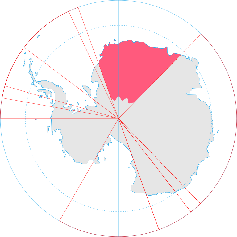
English: Map showing the territorial claim to Antarctica by the country in the filename. Also on the map are is the 60° S Parallel, Antarctic Circle, 0/180 latitude line and (in red) the borders of the claims by other states.
{{Information |Description={{en|Map showing the territorial claim to Antarctica by the country in the filename. Also on the map are is the 60° S Parallel, Antarctic Circle, 0/180 latitude line and (in red) the borders of the claims by other states.}} |So
ไฟล, antarctica, norway, territorial, claim, ไฟล, ประว, ไฟล, หน, าท, ภาพน, การใช, ไฟล, วนกลางขนาดของต, วอย, าง, ของไฟล, กเซล, ความละเอ, ยดอ, กเซล, กเซล, กเซล, กเซล, กเซล, กเซล, ภาพท, ความละเอ, ยดส, งกว, 8206, ไฟล, กเซล, ขนาดไฟล, โลไบต, ปภาพหร, อไฟล, เส, ยงน, น. ifl prawtiifl hnathimiphaphni karichiflswnklangkhnadkhxngtwxyang PNG nikhxngifl SVG ni 600 600 phikesl khwamlaexiydxun 240 240 phikesl 480 480 phikesl 768 768 phikesl 1 024 1 024 phikesl 2 048 2 048 phikesl 806 806 phikesl duphaphthimikhwamlaexiydsungkwa 8206 ifl SVG 806 806 phikesl khnadifl 65 kiolibt rupphaphhruxiflesiyngni tnchbbxyuthi khxmmxns raylaexiyddanlang epnkhxkhwamthiaesdngphlcak ifltnchbbinkhxmmxns khxmmxnsepnewbistinokhrngkarsahrbekbrwbrwmsuxesri thi khunsamarthchwyid khaxthibayAntarctica Norway territorial claim svg English Map showing the territorial claim to Antarctica by the country in the filename Also on the map are is the 60 S Parallel Antarctic Circle 0 180 latitude line and in red the borders of the claims by other states wnthi 30 mithunayn ph s 2551aehlngthima Generated from Antarctica by Lokal Profil phusrangsrrkh Lokal Profilkarxnuyat karichiflniihm iflnixyuphayitsyyaxnuyat khriexthifkhxmmxns aebbaesdngthima xnuyataebbediywkn 2 5 thwipkaraesdngthima Lokal Profilkhunsamarth thicaaebngpn thicathasaena aeckcay aelasngngandngklawtxip thicaeriyberiyngihm thicaddaeplngngandngklaw phayitenguxnikhtxipni aesdngthima khuntxngihekiyrtiecakhxngnganxyangehmaasm odyephimlingkipyngsyyaxnuyat aelarabuhakmikarepliynaeplng khunxacthaechnniidinrupaebbidkidtamkhwr aettxngimichinlksnathiaenawaphuihxnuyatsnbsnunkhunhruxkarichngankhxngkhun xnuyataebbediywkn hakkhunddaeplng epliynrup hruxtxetimnganni khuntxngichsyyaxnuyataebbediywknhruxaebbthiehmuxnkbsyyaxnuyatthiichkbnganniethannhttps creativecommons org licenses by sa 2 5 CC BY SA 2 5 Creative Commons Attribution Share Alike 2 5 true truekhabrryayodyyxithyephimkhabrryaythrrthdediywephuxkhyaykhwamwaiflnimixairixethmthiaesdngxyuiniflniprakxbdwyphusrangbangkhathiimmiixethmwikisnethschuxphusrangsrrkh Lokal Profilyuxaraexl https commons wikimedia org wiki user Lokal Profilchuxphuichwikimiediy Lokal ProfilsthanalikhsiththimilikhsiththisyyaxnuyatCreative Commons Attribution ShareAlike 2 5 Generic xngkvswnthisrang wnkxtng30 mithunayn 2008 prawtiifl khlikwnthi ewlaephuxduiflthipraktinkhnann wnthi ewlarupyxkhnadphuichkhwamehn pccubn03 55 1 krkdakhm 2551806 806 65 kiolibt Lokal Profil Information Description en Map showing the territorial claim to Antarctica by the country in the filename Also on the map are is the 60 S Parallel Antarctic Circle 0 180 latitude line and in red the borders of the claims by other states So hnathimiphaphni hnatxipni oyngmathiphaphni khwinmxdaelnd karichiflswnklang wikixuntxipniichiflni karichbn af wikipedia org Koningin Maudland karichbn ar wikipedia org المطالب الإقليمية بالقارة القطبية الجنوبية karichbn bn wikipedia org র ন মড ভ ম karichbn br wikipedia org Douar ar Rouanez Maud karichbn ca wikipedia org Antartida Terra de la Reina Maud karichbn chr wikipedia org ᏧᏁᏍᏓᎸ karichbn da wikipedia org Dronning Maud Land Wikipedia Dagens skandinaviske artikel Nynorsk Uge 10 2017 karichbn diq wikipedia org Antarktika Sablon Erde Antarktika karichbn el wikipedia org Antarktikh Gh ths Basilissas Mont karichbn en wikipedia org Sverdrup Mountains Gjelsvik Mountains Wikipedia Graphics Lab Map workshop Archive 2017 Jun 2017 karichbn eo wikipedia org Lando de Maud karichbn et wikipedia org Antarktis Kuninganna Maudi maa karichbn eu wikipedia org Maud Erreginaren Lurraldea karichbn fa wikipedia org سرزمین شهبانو ماود karichbn fi wikipedia org Etelamanner karichbn frr wikipedia org Antarktikaa karichbn fr wikipedia org Antarctique karichbn gl wikipedia org Antartida karichbn gv wikipedia org Yn Antarctagh karichbn hu wikipedia org Az Antarktisz teruletei Antarktisz egyezmeny karichbn id wikipedia org Queen Maud Land Pengeklaiman wilayah teritori di Antarktika karichbn ilo wikipedia org Dagiti panagtunton ti teritorio ti Antartika karichbn it wikipedia org Rivendicazioni territoriali in Antartide karichbn ja wikipedia org ドロンニング モード ランド セールロンダーネ山地 karichbn ka wikipedia org დედოფალ მოდის მიწა karichbn kk wikipedia org Mod patshajymynyn zheri karichbn lt wikipedia org Karalienes Matildos Zeme Teritorines pretenzijos Antarktidoje karichbn lv wikipedia org Karalienes Modas Zeme karichbn mi wikipedia org Tiri o te Moana karichbn nl wikipedia org Antarctica karichbn nn wikipedia org Dronning Maud Land Norske biland Kravomrade i Antarktis Wikipedia Utvald artikkel 2017 Wikipedia Utvald artikkel Veke 10 2017 karichbn no wikipedia org Antarktis Wikipedia Ukens artikkel pa nynorsk 2017 Wikipedia Ukens artikkel pa nynorsk Uke 10 2017 karichbn pl wikipedia org Antarktyda dukarichthwolkephimetimkhxngiflni ekhathungcak https th wikipedia org wiki ifl Antarctica Norway territorial claim svg, wikipedia, วิกิ หนังสือ, หนังสือ, ห้องสมุด,