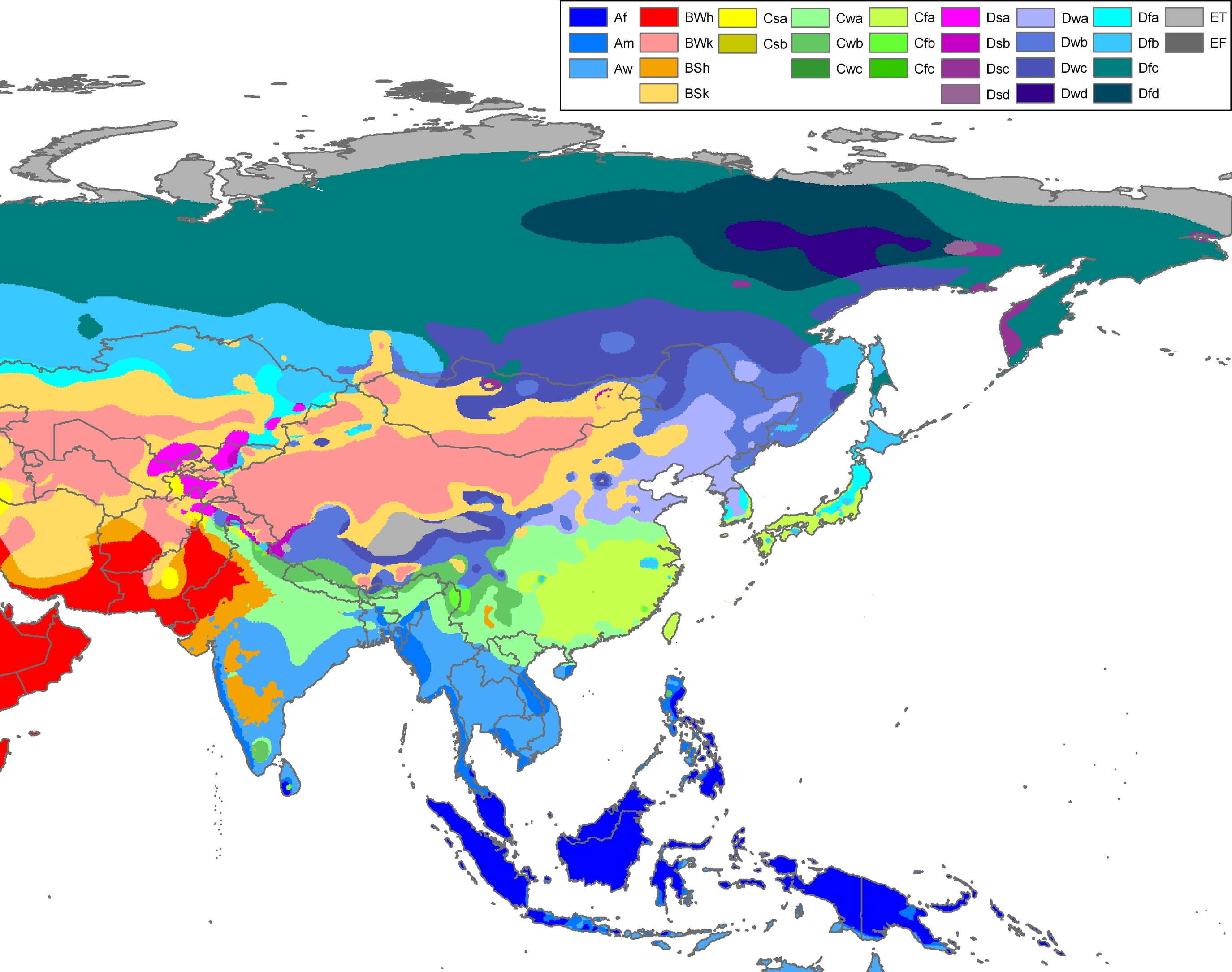
Peel, M. C. and Finlayson, B. L. and McMahon, T. A. (2007). "Updated world map of the Köppen-Geiger climate classification". Hydrol. Earth Syst. Sci.11: 1633-1644. ISSN 1027-5606.
Climate map of Asia, excluding (South)west-Asia (from the "Updated world map of the Köppen-Geiger climate classification").
วันที่
แหล่งที่มา
Hydrology and Earth System Sciences: "Updated world map of the Köppen-Geiger climate classification" (Supplement) - Original file was a JPG-file, this file is has been converted to a PNG-file, without extra modifications, by me (Jeroen).
ผู้สร้างสรรค์
Peel, M. C., Finlayson, B. L., and McMahon, T. A. (University of Melbourne)
Citation: '''Peel, M. C., Finlayson, B. L., and McMahon, T. A.: Updated world map of the Köppen-Geiger climate classification, Hydrol. Earth Syst. Sci., 11, 1633-1644, 2007.''' {{Information |Description= Climate map of Africa (from the "[[:Image:Worl
ไฟล, asia, köppen, ไฟล, ประว, ไฟล, หน, าท, ภาพน, การใช, ไฟล, วนกลางขนาดของต, วอย, างน, กเซล, ความละเอ, ยดอ, กเซล, กเซล, กเซล, กเซล, กเซล, กเซล, ภาพท, ความละเอ, ยดส, งกว, 8206, กเซล, ขนาดไฟล, เมกะไบต, ชน, ดไมม, image, ปภาพหร, อไฟล, เส, ยงน, นฉบ, บอย, คอมมอนส, ร. ifl prawtiifl hnathimiphaphni karichiflswnklangkhnadkhxngtwxyangni 760 599 phikesl khwamlaexiydxun 304 240 phikesl 609 480 phikesl 974 768 phikesl 1 280 1 009 phikesl 2 560 2 019 phikesl 2 749 2 168 phikesl duphaphthimikhwamlaexiydsungkwa 8206 2 749 2 168 phikesl khnadifl 1 49 emkaibt chnidimm image png rupphaphhruxiflesiyngni tnchbbxyuthi khxmmxns raylaexiyddanlang epnkhxkhwamthiaesdngphlcak ifltnchbbinkhxmmxns khxmmxnsepnewbistinokhrngkarsahrbekbrwbrwmsuxesri thi khunsamarthchwyid Peel M C and Finlayson B L and McMahon T A 2007 Updated world map of the Koppen Geiger climate classification Hydrol Earth Syst Sci 11 1633 1644 ISSN 1027 5606 enuxha 1 Legend 2 khwamyx 3 Related maps 4 karxnuyatichsiththiphaphaephnthini khwrcathuksrangihmepnkrafiksewketxr sungmikhxdixikhlayprakar duephimetimthikhxmmxns suxtxngkarekbkwadsahrbsarsnethsephimetim hakphaphnimiinrupaebbkrafiksewketxrxyuaelw krunaxpohldaelaaethnthiaemaebbnidwy vector version available i chuxphaphihm i aenanaepnxyangyingihtngchuxiflewketxrihmnninrupaebb Asia Koppen Map svg aelwisaemaebb Vector version available hrux Vva sungimtxngichpharamietxr chuxphaphihmLegend Af equatorial climate Am monsoon climate Aw tropical savanna climate BWh warm desert climate BWk cold desert climate BSh warm semi arid climate BSk cold semi arid climate Csa warm mediterranean climate Csb temperate mediterranean climate Cwa humid subtropical climate Cwb humid subtropical climate subtropical oceanic highland climate Cwc oceanic subpolar climate Cfa warm oceanic climate humid subtropical climate Cfb temperate oceanic climate Cfc cool oceanic climate Dsa warm continental climate mediterranean continental climate Dsb temperate continental climate mediterranean continental climate Dsc cool continental climate Dsd cold continental climate Dwa warm continental climate humid continental climate Dwb temperate continental climate humid continental climate Dwc cool continental climate subarctic climate Dwd cold continental climate subarctic climate Dfa warm continental climate humid continental climate Dfb temperate continental climate humid continental climate Dfc cool continental climate subarctic climate Dfd cold continental climate subarctic climate ET tundra climate EF ice cap climateEnglish khwamyx khaxthibayAsia Koppen Map png Climate map of Asia excluding South west Asia from the Updated world map of the Koppen Geiger climate classification wnthi 12 tulakhm ph s 2550aehlngthima Hydrology and Earth System Sciences Updated world map of the Koppen Geiger climate classification Supplement Original file was a JPG file this file is has been converted to a PNG file without extra modifications by me Jeroen phusrangsrrkh Peel M C Finlayson B L and McMahon T A University of Melbourne karxnuyat karichiflniihm khxkhwamxnuyatcakecakhxnglikhsiththiihichnganphaphhruxsuxni idrbkartrwcsxbaelw aelathukekbiwinxasasmkhrtxbklbxieml VRT odysahrbphuichthimibychi VRT samarthtrwcsxbbnthukekiywkbkhxkhwamxnuyatnnid inbnthukhmayelkh 2011040110025998 hakthantxngkarnaphaphhruxsuxniipichthixunnxkehnuxcakinmulnithiwikimiediy krunaxankhxmulekiywkbkarnaenuxhaipichnxkmulnithiwikimiediythihnani thngnihakthanprasngkhcakhxkhayunynekiywkbkarxnuyatihichichphaphhruxsuxni krunatidtxphuichthimibychi VRT hruxaecngphanhnaaecng VRT lingkkhxngbnthuk https ticket wikimedia org otrs index pl Action AgentTicketZoom amp TicketNumber 2011040110025998 Find other files from the same ticket Related maps User Jeroenvrp made for these continents and areas a cropped and resized version Africa Koppen Map png Asia Koppen Map png Australia Oceania Koppen Map png Europe Koppen Map png North America Koppen Map png Russia Koppen Map png South America Koppen Map png West Asia Koppen Map png User LordToran made from the same data these maps Klimagurtel der erde eisklima png Klimagurtel der erde gemassigte zone png Klimagurtel der erde polargebiete png Klimagurtel der erde subtropen png Klimagurtel der erde tropen png Klimagurtel der erde tundra png Klimagurtel der erde warmgemassigte zone png Klimagurtel der erde png Klimagurtel der erde svg Klimate humiditat png Koppen geiger hessd 2007 svg Koppen vereinfacht svg Trockenklimate pngkarxnuyatichsiththi iflnixyuphayitsyyaxnuyat khriexthifkhxmmxns aebbaesdngthima xnuyataebbediywkn 3 0 tnchbbkhunsamarth thicaaebngpn thicathasaena aeckcay aelasngngandngklawtxip thicaeriyberiyngihm thicaddaeplngngandngklaw phayitenguxnikhtxipni aesdngthima khuntxngihekiyrtiecakhxngnganxyangehmaasm odyephimlingkipyngsyyaxnuyat aelarabuhakmikarepliynaeplng khunxacthaechnniidinrupaebbidkidtamkhwr aettxngimichinlksnathiaenawaphuihxnuyatsnbsnunkhunhruxkarichngankhxngkhun xnuyataebbediywkn hakkhunddaeplng epliynrup hruxtxetimnganni khuntxngichsyyaxnuyataebbediywknhruxaebbthiehmuxnkbsyyaxnuyatthiichkbnganniethannhttps creativecommons org licenses by sa 3 0 CC BY SA 3 0 Creative Commons Attribution Share Alike 3 0 true true phaph meteorology ni khwrcathuksrangihmepnkrafiksewketxr sungmikhxdixikhlayprakar duephimetimthikhxmmxns suxtxngkarekbkwadsahrbsarsnethsephimetim hakphaphnimiinrupaebbkrafiksewketxrxyuaelw krunaxpohldaelaaethnthiaemaebbnidwy vector version available i chuxphaphihm i aenanaepnxyangyingihtngchuxiflewketxrihmnninrupaebb Asia Koppen Map svg aelwisaemaebb Vector version available hrux Vva sungimtxngichpharamietxr chuxphaphihmkhabrryayodyyxithyephimkhabrryaythrrthdediywephuxkhyaykhwamwaiflnimixairyipunケッペンの気候区分 アジアixethmthiaesdngxyuiniflniprakxbdwykaraebngekhtphumixakasaebbekhiphephinKoppen xngkvssthanalikhsiththimilikhsiththisyyaxnuyatCreative Commons Attribution ShareAlike 3 0 Unported xngkvsWikimedia VRTS ticket number xngkvs2011040110025998wnthisrang wnkxtng12 tulakhm 2007MIME type xngkvsimage png prawtiifl khlikwnthi ewlaephuxduiflthipraktinkhnann wnthi ewlarupyxkhnadphuichkhwamehn pccubn05 51 13 tulakhm 25502 749 2 168 1 49 emkaibt JeroenCitation 039 039 039 Peel M C Finlayson B L and McMahon T A Updated world map of the Koppen Geiger climate classification Hydrol Earth Syst Sci 11 1633 1644 2007 039 039 039 Information Description Climate map of Africa from the Image Worl hnathimiphaphni hnatxipni oyngmathiphaphni karaebngekhtphumixakasaebbekhiphephin karichiflswnklang wikixuntxipniichiflni karichbn cs wikipedia org Koppenova klasifikace podnebi karichbn en wikipedia org Ecocrop karichbn eo wikipedia org Klimato Klimata klasifiko de Koppen karichbn es wikipedia org Tianjin karichbn es wikibooks org Wikichicos La Tierra Los continentes Asia Clima Wikichicos La Tierra Texto completo karichbn fy wikipedia org Klimaatklassifikaasje fan Koppen karichbn gl wikipedia org Asia karichbn ilo wikipedia org Ecocrop karichbn ja wikipedia org ケッペンの気候区分 アムダリヤ川 アラル海 karichbn mk wikipedia org Kepenova klasifikaciјa na klimata karichbn nl wikipedia org Azie karichbn pt wikipedia org Asia Ecocrop karichbn simple wikipedia org Tashkent karichbn sl wikipedia org Koppnova podnebna klasifikacija karichbn tr wikipedia org Asya karichbn zea wikipedia org Azie ekhathungcak https th wikipedia org wiki ifl Asia Koppen Map png, wikipedia, วิกิ หนังสือ, หนังสือ, ห้องสมุด,