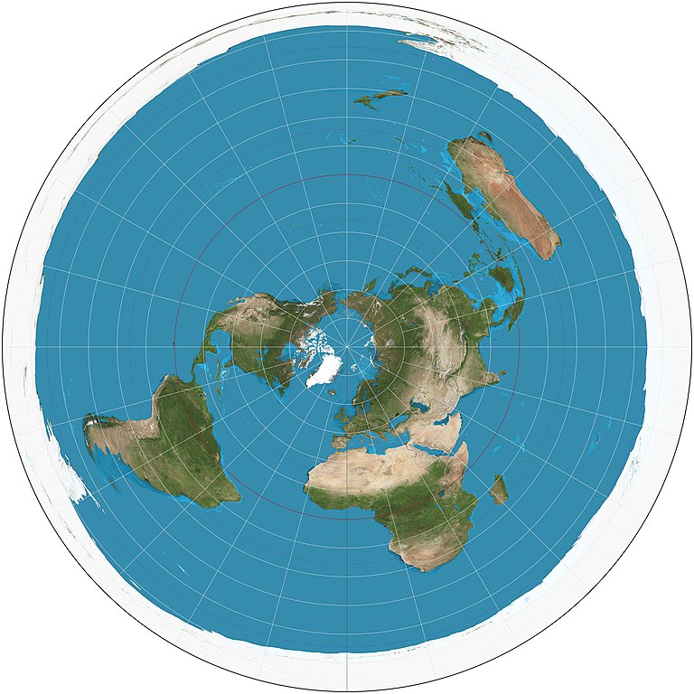
English: The world on azimuthal equidistant projection. 15° graticule, polar aspect. Imagery is a derivative of NASA’s Blue Marble summer month composite with oceans lightened to enhance legibility and contrast. Image created with the Geocart map projection software.
ไฟล, azimuthal, equidistant, projection, ไฟล, ประว, ไฟล, หน, าท, ภาพน, การใช, ไฟล, วนกลาง, อม, ลเก, ยวก, บภาพขนาดของต, วอย, างน, กเซล, ความละเอ, ยดอ, กเซล, กเซล, กเซล, กเซล, กเซล, ภาพท, ความละเอ, ยดส, งกว, 8206, กเซล, ขนาดไฟล, โลไบต, ชน, ดไมม, image, jpeg, ปภา. ifl prawtiifl hnathimiphaphni karichiflswnklang khxmulekiywkbphaphkhnadkhxngtwxyangni 600 600 phikesl khwamlaexiydxun 240 240 phikesl 480 480 phikesl 768 768 phikesl 1 024 1 024 phikesl 2 058 2 058 phikesl duphaphthimikhwamlaexiydsungkwa 8206 2 058 2 058 phikesl khnadifl 975 kiolibt chnidimm image jpeg rupphaphhruxiflesiyngni tnchbbxyuthi khxmmxns raylaexiyddanlang epnkhxkhwamthiaesdngphlcak ifltnchbbinkhxmmxns khxmmxnsepnewbistinokhrngkarsahrbekbrwbrwmsuxesri thi khunsamarthchwyid nikhuxphaphkhdsrrinwikiphiediyphasaxngkvs Featured pictures aela khux thuxwaepn phaphxyangidxyanghnungthidithisudthakhidwaiflnikhwrcaihkhwamsakhykbwikimiediykhxmmxnsepnxyangdi xyalngelthica esnxchux hakkhunmiphaphthimikhunphaph khlaykhlungkn thicasamarthephyaephridtam syyaxnuyatthiehmaasm ihaenicwa khunid xpohld kahndsyyaxnuyat aelaid esnxchuxaelw khwamyx khaxthibayAzimuthal equidistant projection SW jpg English The world on azimuthal equidistant projection 15 graticule polar aspect Imagery is a derivative of NASA s Blue Marble summer month composite with oceans lightened to enhance legibility and contrast Image created with the Geocart map projection software wnthi 15 singhakhm ph s 2554aehlngthima ngankhxngtwphusrangsrrkh Strebe karxnuyatichsiththi khapheca inthanaphuthuxlikhsiththikhxngphaphhruxsuxni xnuyatihichphaphhruxsuxniphayitenguxnikhtxipniiflnixyuphayitsyyaxnuyat khriexthifkhxmmxns aebbaesdngthima xnuyataebbediywkn 3 0 tnchbbkhunsamarth thicaaebngpn thicathasaena aeckcay aelasngngandngklawtxip thicaeriyberiyngihm thicaddaeplngngandngklaw phayitenguxnikhtxipni aesdngthima khuntxngihekiyrtiecakhxngnganxyangehmaasm odyephimlingkipyngsyyaxnuyat aelarabuhakmikarepliynaeplng khunxacthaechnniidinrupaebbidkidtamkhwr aettxngimichinlksnathiaenawaphuihxnuyatsnbsnunkhunhruxkarichngankhxngkhun xnuyataebbediywkn hakkhunddaeplng epliynrup hruxtxetimnganni khuntxngichsyyaxnuyataebbediywknhruxaebbthiehmuxnkbsyyaxnuyatthiichkbnganniethannhttps creativecommons org licenses by sa 3 0 CC BY SA 3 0 Creative Commons Attribution Share Alike 3 0 true truekhabrryayodyyxithyephimkhabrryaythrrthdediywephuxkhyaykhwamwaiflnimixairxngkvsThe world on azimuthal equidistant projection north polar view ixethmthiaesdngxyuiniflniprakxbdwyphusrangbangkhathiimmiixethmwikisnethshnathikhxngwtthuphayitpraphcnni changphaphchuxphusrangsrrkh Strebechuxphuichwikimiediy Strebeyuxaraexl http commons wikimedia org wiki User StrebesthanalikhsiththimilikhsiththisyyaxnuyatCreative Commons Attribution ShareAlike 3 0 Unported xngkvswnthisrang wnkxtng15 singhakhm 2011thimakhxngiflkarsrangdngedimodyphuxpohld prawtiifl khlikwnthi ewlaephuxduiflthipraktinkhnann wnthi ewlarupyxkhnadphuichkhwamehn pccubn05 17 16 singhakhm 25542 058 2 058 975 kiolibt Strebe hnathimiphaphni hnatxipni oyngmathiphaphni aephnthiolk karichiflswnklang wikixuntxipniichiflni karichbn ar wikipedia org قائمة مساقط الخرائط karichbn bn wikipedia org ব শ ব র ম নচ ত র karichbn cs wikipedia org Mapa sveta karichbn de wikipedia org Liste von Kartennetzentwurfen karichbn en wikipedia org User talk Strebe World map Azimuthal equidistant projection Talk Azimuthal equidistant projection Wikipedia Featured pictures Diagrams drawings and maps Maps User talk Cowtowner List of map projections Wikipedia Featured pictures thumbs 35 Wikipedia Featured picture candidates June 2013 Wikipedia Featured picture candidates Map Projections Set User R Portela F Wikipedia Picture of the day May 2016 Template POTD 2016 05 19 Wikipedia Main Page history 2016 May 19 Template User Flat Earth Interruption map projection Portal Geography Selected picture User Hades699 karichbn en wiktionary org azimuthal karichbn es wikipedia org Anexo Cronologia de las proyecciones cartograficas karichbn et wikipedia org Tasandilised projektsioonid karichbn fi wikipedia org Oikeakeskipituinen tasoprojektio karichbn fr wikipedia org Liste de projections cartographiques karichbn fr wikiversity org Representations et cartes du monde Representation Dynamiques de la mondialisation Exercices Croquis poles et flux Dynamiques de la mondialisation Exercices Croquis territoires integres karichbn ha wikipedia org Taswirar duniya karichbn he wikipedia org מפת העולם משתמש WikiJunkie מפת העולם karichbn hu wikipedia org Szerkeszto Texaner vetuletek listaja karichbn hy wikipedia org Աշխարհի քարտեզ Կաղապար Աշխարհի քարտեզ karichbn id wikipedia org Wikipedia Kotak pengguna Kepercayaan Templat Pengguna bumi datar karichbn it wikipedia org Terra piatta Lista delle proiezioni cartografiche karichbn nl wikipedia org Gebruiker KoenB Kladblok karichbn pl wikipedia org Odwzorowanie azymutalne rownoodleglosciowe karichbn pnb wikipedia org عالمی نقشہ karichbn pt wikipedia org Projecao azimutal karichbn ru wikipedia org Karta mira Spisok kartograficheskih proekcij karichbn uk wikipedia org Karta svitu Perelik kartografichnih proyekcij karichbn ur wikipedia org عالمی نقشہ karichbn zh wikipedia org Draft 地图投影列表khxmulekiywkbphaph phaphnimikhxmulephimetim sungswnihymacakklxngdicitxlhruxsaeknenxrthisamarthekbkhxmuldngklawiwrwmkbphaphid thaphaphnithukprbprungaekikhhruxepliynaeplngcakedim khxmulbangxyangcayngkhngimepliynaeplngehmuxnphaphthithukprbprungaekikhnnkhwamkwang2 058 phikeslkhwamsung2 058 phikeslrupaebbkarbibxdimidbibxdphikeslkhxmophsichnRGBkarcdwangphaphpkticanwnkhxmophennt4khwamlaexiydaenwnxn28 3465 dpckhwamlaexiydaenwtng28 3465 dpckarcderiyngkhxmulrupaebbchngkisxftaewrthiichAdobe Photoshop CS5 Macintoshaekikhphaphlasud02 29 15 singhakhm 2554sepssiimidprbethiyb ekhathungcak https th wikipedia org wiki ifl Azimuthal equidistant projection SW jpg, wikipedia, วิกิ หนังสือ, หนังสือ, ห้องสมุด,