รูปภาพหรือไฟล์เสียงนี้ ต้นฉบับอยู่ที่ คอมมอนส์ รายละเอียดด้านล่าง เป็นข้อความที่แสดงผลจาก ไฟล์ต้นฉบับในคอมมอนส์ คอมมอนส์เป็นเว็บไซต์ในโครงการสำหรับเก็บรวบรวมสื่อเสรี ที่ คุณสามารถช่วยได้
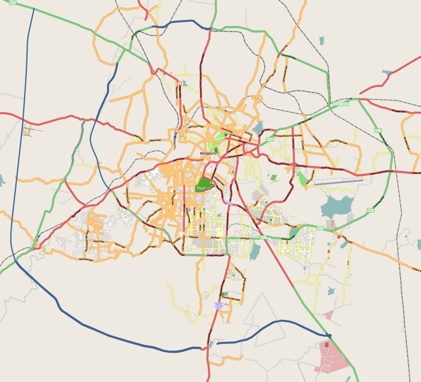
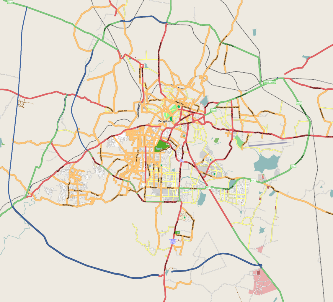
คำอธิบายBangalore street Map.png English:
วันที่ 31 ธันวาคม พ.ศ. 2551 (original upload date)
(Original text: 30th December 2008 ) แหล่งที่มา openstreetmap.org ผู้สร้างสรรค์ Collaboratively created by the OpenStreetMap community using only free map sources and manual GPS surveying to build the map from scratch. Raise lkblr grabbed this image from OpenStreetMap การอนุญาต(การใช้ไฟล์นี้ใหม่) See OpenStreetMap License for details. เวอร์ชันอื่น The 'live' version of this map is available at http://www.openstreetmap.org/?lat=12.9536&lon=77.598&zoom=13 Use the 'export' tab to get a fresh export in a variety of formats, including SVG and '.osm', the underlying geolocated data. Use the 'edit' tab there to edit the map!
ความย่อ Latitudes from 77.46 to 77.72
Longitude from 12.83 to 13.06
การอนุญาตใช้สิทธิ
ไฟล์นี้อยู่ภายใต้สัญญาอนุญาตครีเอทีฟคอมมอนส์ รุ่น แสดงที่มา 2.0 ทั่วไป
คุณสามารถ: ที่จะแบ่งปัน – ที่จะทำสำเนา แจกจ่าย และส่งงานดังกล่าวต่อไปที่จะเรียบเรียงใหม่ – ที่จะดัดแปลงงานดังกล่าว ภายใต้เงื่อนไขต่อไปนี้: แสดงที่มา – คุณต้องให้เกียรติเจ้าของงานอย่างเหมาะสม โดยเพิ่มลิงก์ไปยังสัญญาอนุญาต และระบุหากมีการเปลี่ยนแปลง คุณอาจทำเช่นนี้ได้ในรูปแบบใดก็ได้ตามควร แต่ต้องไม่ใช่ในลักษณะที่แนะว่าผู้ให้อนุญาตสนับสนุนคุณหรือการใช้งานของคุณ https://creativecommons.org/licenses/by/2.0 CC BY 2.0 Creative Commons Attribution 2.0 true true บันทึกการอัพโหลด นำเข้าจาก en.wikipedia มายังคอมมอนส์ โดย Closedmouth
The original description page was here. All following user names refer to en.wikipedia.
2008-12-31 03:39 Raise lkblr 1722×1563× (789839 bytes) 2008-12-30 08:49 Raise lkblr 1656×1019× (632450 bytes) updated 2008-12-30 08:34 Raise lkblr 1517×1520× (790374 bytes) from http://openstreetmap.org/ ไทย เพิ่มคำบรรยายทรรทัดเดียวเพื่อขยายความว่าไฟล์นี้มีอะไร
อังกฤษ Bangalore street map
ประวัติไฟล์ คลิกวันที่/เวลาเพื่อดูไฟล์ที่ปรากฏในขณะนั้น
วันที่/เวลา รูปย่อ ขนาด ผู้ใช้ ความเห็น ปัจจุบัน 13:32, 20 กรกฎาคม 2555 1,722 × 1,563 (855 กิโลไบต์) Wantsallanger enhanced contrast 13:59, 4 มีนาคม 2554 1,722 × 1,563 (861 กิโลไบต์) Raise lkblr updated completed ring road 21:47, 24 มีนาคม 2552 1,722 × 1,563 (771 กิโลไบต์) Closedmouth {{Information |Description={{en|Map of en:Bangalore, India<br/> en:Category:OpenStreetMap maps}} |Source=Transferred from [http://en.wikipedia.org en.wikipedia]; transfer was stated to be made by User:Closedmouth .<br/> (Original text : ''[ht
หน้าที่มีภาพนี้ หน้าต่อไปนี้ โยงมาที่ภาพนี้:
การใช้ไฟล์ส่วนกลาง วิกิอื่นต่อไปนี้ใช้ไฟล์นี้:
ইলেকট্রনিক সিটি মডিউল:অবস্থান মানচিত্র/উপাত্ত/ভারত বেঙ্গালুরু মডিউল:অবস্থান মানচিত্র/উপাত্ত/ভারত বেঙ্গালুরু/নথি বিধান সৌধ ডাঃ বি.আর. আম্বেদকর স্টেশন, বিধান সৌধ মেট্রো স্টেশন স্বামী বিবেকানন্দ রোড মেট্রো স্টেশন বাইয়াপ্পনহাল্লি মেট্রো স্টেশন ইন্দিরানগর মেট্রো স্টেশন হালাসুরু মেট্রো স্টেশন মহাত্মা গান্ধী রোড মেট্রো স্টেশন (বেঙ্গালুরু) কাবন পার্ক মেট্রো স্টেশন কেঙ্গেরি মেট্রো স্টেশন Vidhana Soudha Whitefield, Bangalore B.M.S. College of Engineering R.V. College of Engineering Jayanagar, Bangalore Lal Bagh Domlur HAL Airport Madiwala Basaveshwaranagara Koramangala Hebbal, Bangalore Indiranagar HSR Layout Begur, Bangalore Basavanagudi Cubbon Park Ulsoor Hulimavu Shivajinagar, Bangalore Yelachenahalli Bommanahalli Gottigere Kengeri Konanakunte Krishnarajapuram Mahadevapura, Bangalore Uttarahalli Malleshwaram, Bengaluru Hoodi Arekere ดูการใช้ทั่วโลกเพิ่มเติม ของไฟล์นี้
ภาพนี้มีข้อมูลเพิ่มเติม ซึ่งส่วนใหญ่มาจากกล้องดิจิตอลหรือสแกนเนอร์ที่สามารถเก็บข้อมูลดังกล่าวไว้รวมกับภาพได้ ถ้าภาพนี้ถูกปรับปรุงแก้ไขหรือเปลี่ยนแปลงจากเดิม ข้อมูลบางอย่างจะยังคงไม่เปลี่ยนแปลงเหมือนภาพที่ถูกปรับปรุงแก้ไขนั้น
ไฟล, bangalore, street, ไฟล, ประว, ไฟล, หน, าท, ภาพน, การใช, ไฟล, วนกลาง, อม, ลเก, ยวก, บภาพขนาดของต, วอย, างน, กเซล, ความละเอ, ยดอ, กเซล, กเซล, กเซล, กเซล, กเซล, ภาพท, ความละเอ, ยดส, งกว, 8206, กเซล, ขนาดไฟล, โลไบต, ชน, ดไมม, image, ปภาพหร, อไฟล, เส, ยงน, นฉบ. ifl prawtiifl hnathimiphaphni karichiflswnklang khxmulekiywkbphaphkhnadkhxngtwxyangni 661 600 phikesl khwamlaexiydxun 264 240 phikesl 529 480 phikesl 846 768 phikesl 1 128 1 024 phikesl 1 722 1 563 phikesl duphaphthimikhwamlaexiydsungkwa 8206 1 722 1 563 phikesl khnadifl 855 kiolibt chnidimm image png rupphaphhruxiflesiyngni tnchbbxyuthi khxmmxns raylaexiyddanlang epnkhxkhwamthiaesdngphlcak ifltnchbbinkhxmmxns khxmmxnsepnewbistinokhrngkarsahrbekbrwbrwmsuxesri thi khunsamarthchwyid khaxthibayBangalore street Map png English Map of en Bangalore India Coordinates top 13 06 bottom 12 83 left 77 46 right 77 72 wnthi 31 thnwakhm ph s 2551 original upload date Original text 30th December 2008 aehlngthima openstreetmap orgphusrangsrrkh Collaboratively created by the OpenStreetMap community using only free map sources and manual GPS surveying to build the map from scratch Raise lkblr grabbed this image from OpenStreetMapkarxnuyat karichiflniihm See OpenStreetMap License for details ewxrchnxun The live version of this map is available at http www openstreetmap org lat 12 9536 amp lon 77 598 amp zoom 13 Use the export tab to get a fresh export in a variety of formats including SVG and osm the underlying geolocated data Use the edit tab there to edit the map khwamyx Latitudes from 77 46 to 77 72Longitude from 12 83 to 13 06 karxnuyatichsiththi iflnixyuphayitsyyaxnuyatkhriexthifkhxmmxns run aesdngthima 2 0 thwipkhunsamarth thicaaebngpn thicathasaena aeckcay aelasngngandngklawtxip thicaeriyberiyngihm thicaddaeplngngandngklaw phayitenguxnikhtxipni aesdngthima khuntxngihekiyrtiecakhxngnganxyangehmaasm odyephimlingkipyngsyyaxnuyat aelarabuhakmikarepliynaeplng khunxacthaechnniidinrupaebbidkidtamkhwr aettxngimichinlksnathiaenawaphuihxnuyatsnbsnunkhunhruxkarichngankhxngkhunhttps creativecommons org licenses by 2 0 CC BY 2 0 Creative Commons Attribution 2 0 true true bnthukkarxphohldnaekhacak en wikipedia mayngkhxmmxns ody ClosedmouthThe original description page was here All following user names refer to en wikipedia 2008 12 31 03 39 Raise lkblr 1722 1563 789839 bytes 2008 12 30 08 49 Raise lkblr 1656 1019 632450 bytes updated 2008 12 30 08 34 Raise lkblr 1517 1520 790374 bytes from http openstreetmap org khabrryayodyyxithyephimkhabrryaythrrthdediywephuxkhyaykhwamwaiflnimixairxngkvsBangalore street mapixethmthiaesdngxyuiniflniprakxbdwysthanalikhsiththimilikhsiththisyyaxnuyatCreative Commons Attribution 2 0 Generic xngkvswnthisrang wnkxtng31 thnwakhm 2008MIME type xngkvsimage png prawtiifl khlikwnthi ewlaephuxduiflthipraktinkhnann wnthi ewlarupyxkhnadphuichkhwamehn pccubn13 32 20 krkdakhm 25551 722 1 563 855 kiolibt Wantsallangerenhanced contrast 13 59 4 minakhm 25541 722 1 563 861 kiolibt Raise lkblrupdated completed ring road 21 47 24 minakhm 25521 722 1 563 771 kiolibt Closedmouth Information Description en Map of en Bangalore India lt br gt en Category OpenStreetMap maps Source Transferred from http en wikipedia org en wikipedia transfer was stated to be made by User Closedmouth lt br gt Original text 039 039 ht hnathimiphaphni hnatxipni oyngmathiphaphni lalbakh ebngkhluru mxdul Location map data India Bengaluru mxdul Location map data India Bengaluru doc karichiflswnklang wikixuntxipniichiflni karichbn af wikipedia org Bangalore karichbn ar wikipedia org قالب Location map India Bengaluru karichbn ba wikipedia org Bangalor karichbn bn wikipedia org ব ম মন হ ল ল ইল কট রন ক স ট মড উল অবস থ ন ম নচ ত র উপ ত ত ভ রত ব ঙ গ ল র মড উল অবস থ ন ম নচ ত র উপ ত ত ভ রত ব ঙ গ ল র নথ ব ধ ন স ধ ড ব আর আম ব দকর স ট শন ব ধ ন স ধ ম ট র স ট শন স ব ম ব ব ক নন দ র ড ম ট র স ট শন ব ইয প পনহ ল ল ম ট র স ট শন ইন দ র নগর ম ট র স ট শন হ ল স র ম ট র স ট শন মহ ত ম গ ন ধ র ড ম ট র স ট শন ব ঙ গ ল র ক বন প র ক ম ট র স ট শন ক ঙ গ র ম ট র স ট শন karichbn ca wikipedia org Bangalore karichbn ceb wikipedia org Plantilya Location map India Bengaluru karichbn en wikipedia org Visvesvaraya Industrial and Technological Museum Vidhana Soudha Whitefield Bangalore B M S College of Engineering R V College of Engineering Jayanagar Bangalore Lal Bagh Domlur HAL Airport Madiwala Basaveshwaranagara Koramangala Hebbal Bangalore Indiranagar HSR Layout Begur Bangalore Basavanagudi Cubbon Park Ulsoor Hulimavu Shivajinagar Bangalore Yelachenahalli Bommanahalli Gottigere Kengeri Konanakunte Krishnarajapuram Mahadevapura Bangalore Uttarahalli Malleshwaram Bengaluru Hoodi Arekere dukarichthwolkephimetimkhxngiflnikhxmulekiywkbphaph phaphnimikhxmulephimetim sungswnihymacakklxngdicitxlhruxsaeknenxrthisamarthekbkhxmuldngklawiwrwmkbphaphid thaphaphnithukprbprungaekikhhruxepliynaeplngcakedim khxmulbangxyangcayngkhngimepliynaeplngehmuxnphaphthithukprbprungaekikhnnkhwamlaexiydaenwnxn37 78 dpckhwamlaexiydaenwtng37 78 dpc ekhathungcak https th wikipedia org wiki ifl Bangalore street Map png, wikipedia, วิกิ หนังสือ, หนังสือ, ห้องสมุด,
บทความ , อ่าน, ดาวน์โหลด, ฟรี, ดาวน์โหลดฟรี, mp3, วิดีโอ, mp4, 3gp, jpg, jpeg, gif, png, รูปภาพ, เพลง, เพลง, หนัง, หนังสือ, เกม, เกม