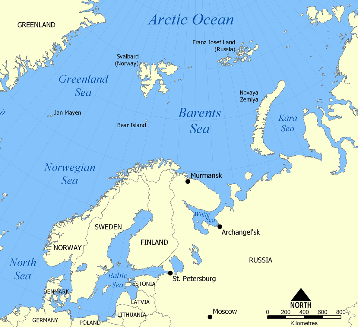
English: The location of the Barents Sea north of Russia and Norway, and the surrounding seas and islands. Also includes political borders with their corresponding nation-states listed.
This map shows the location of the Barents Sea north of Russia and Norway, and the surrounding seas and islands. Created by NormanEinstein, November 25, 2005. {{GFDL-self}} Category:Maps of seas
ไฟล, barents, ไฟล, ประว, ไฟล, หน, าท, ภาพน, การใช, ไฟล, วนกลางขนาดของต, วอย, างน, กเซล, ความละเอ, ยดอ, กเซล, กเซล, กเซล, กเซล, ภาพท, ความละเอ, ยดส, งกว, 8206, กเซล, ขนาดไฟล, โลไบต, ชน, ดไมม, image, ปภาพหร, อไฟล, เส, ยงน, นฉบ, บอย, คอมมอนส, รายละเอ, ยดด, านล, า. ifl prawtiifl hnathimiphaphni karichiflswnklangkhnadkhxngtwxyangni 657 600 phikesl khwamlaexiydxun 263 240 phikesl 526 480 phikesl 841 768 phikesl 1 187 1 084 phikesl duphaphthimikhwamlaexiydsungkwa 8206 1 187 1 084 phikesl khnadifl 654 kiolibt chnidimm image png rupphaphhruxiflesiyngni tnchbbxyuthi khxmmxns raylaexiyddanlang epnkhxkhwamthiaesdngphlcak ifltnchbbinkhxmmxns khxmmxnsepnewbistinokhrngkarsahrbekbrwbrwmsuxesri thi khunsamarthchwyid khwamyx khaxthibayBarents Sea map png English The location of the Barents Sea north of Russia and Norway and the surrounding seas and islands Also includes political borders with their corresponding nation states listed wnthi 25 phvscikayn ph s 2548 16 40 aehlngthima ngankhxngtw phusrangsrrkh NormanEinstein ewxrchnxun aekikh Norwegian Sea bosanski cestina dansk Deutsch eesti English francais francais Jan Mayen localisation hrvatski italiano magyar magyar norsk svenska makedonski nohchijn russkij ukrayinska 中文 עברית Barents Sea Deutsch English espanol hrvatski magyar Kiswahili russkij Ellhnika karxnuyatichsiththi khapheca inthanaphuthuxlikhsiththikhxngphaphhruxsuxni xnuyatihichphaphhruxsuxniphayitenguxnikhtxipni xnuyatihkhdlxk aeckcayaela hruxddaeprexksarniphayitenguxnikhkhxngsyyaxnuyatexksaresrikhxngknu run 1 2 hruxrunid nbcaknithixxkodymulnithisxftaewresri odyimmiswnidhamaekikh immikhxkhwampkhnaaelapkhlng saenakhxngsyyaxnuyatrwmxyuinswnchux syyaxnuyatexksaresrikhxngknuhttp www gnu org copyleft fdl html GFDL GNU Free Documentation License true true iflnixyuphayitsyyaxnuyat khriexthifkhxmmxns aebbaesdngthima xnuyataebbediywkn 3 0 tnchbb khunsamarth thicaaebngpn thicathasaena aeckcay aelasngngandngklawtxip thicaeriyberiyngihm thicaddaeplngngandngklaw phayitenguxnikhtxipni aesdngthima khuntxngihekiyrtiecakhxngnganxyangehmaasm odyephimlingkipyngsyyaxnuyat aelarabuhakmikarepliynaeplng khunxacthaechnniidinrupaebbidkidtamkhwr aettxngimichinlksnathiaenawaphuihxnuyatsnbsnunkhunhruxkarichngankhxngkhun xnuyataebbediywkn hakkhunddaeplng epliynrup hruxtxetimnganni khuntxngichsyyaxnuyataebbediywknhruxaebbthiehmuxnkbsyyaxnuyatthiichkbnganniethann payaesdngsthanalikhsiththinithukephimephuxihepniptamkarepliynaeplngsyyaxnuyatkhxngmulnithiwikimiediy cak GFDL ipyng GFDL khwbkhukb CC BY SA 3 0 http creativecommons org licenses by sa 3 0 CC BY SA 3 0 Creative Commons Attribution Share Alike 3 0 true truekhunsamartheluxksyyaxnuyatdngklawtamtxngkarkhabrryayodyyxithyephimkhabrryaythrrthdediywephuxkhyaykhwamwaiflnimixairxngkvsThe location of the Barents SeaswiednBarents Seaixethmthiaesdngxyuiniflniprakxbdwythaelaeberntsphusrangbangkhathiimmiixethmwikisnethsyuxaraexl https commons wikimedia org wiki user NormanEinsteinchuxphuichwikimiediy NormanEinsteinchuxphusrangsrrkh NormanEinsteinsthanalikhsiththimilikhsiththisyyaxnuyatCreative Commons Attribution ShareAlike 3 0 Unported nbsp xngkvsGNU Free Documentation License version 1 2 or later nbsp xngkvsthimakhxngiflkarsrangdngedimodyphuxpohldwnthisrang wnkxtng25 phvscikayn 2005MIME type nbsp xngkvsimage pngchecksum nbsp xngkvsf7a5ee6d4b4514fe0c001142a4b0f0bf17f69b6fwithikarkahnd SHA 1 nbsp xngkvsdata size nbsp xngkvs669 295 ibtkhwamsung1 084 phikeslkhwamkwang1 187 phikesl prawtiifl khlikwnthi ewlaephuxduiflthipraktinkhnann wnthi ewlarupyxkhnadphuichkhwamehn pccubn03 52 30 minakhm 25551 187 1 084 654 kiolibt Ras67cropped 13 11 5 kumphaphnth 25491 200 1 098 680 kiolibt Berkut commonswikipngout ed 13 file size reduction 23 40 25 phvscikayn 25481 200 1 098 781 kiolibt NormanEinsteinThis map shows the location of the Barents Sea north of Russia and Norway and the surrounding seas and islands Created by NormanEinstein November 25 2005 GFDL self Category Maps of seas hnathimiphaphni hnatxipni oyngmathiphaphni thaelaebernts karichiflswnklang wikixuntxipniichiflni karichbn af wikipedia org Moermansk Barentssee karichbn ar wikipedia org بحر بارنتس karichbn ast wikipedia org Mar de Barents karichbn azb wikipedia org بارنس دنیزی karichbn bcl wikipedia org Dagat Barents karichbn be tarask wikipedia org Barancava mora karichbn bg wikipedia org Barencovo more karichbn bn wikipedia org ব র ন টস স গর karichbn bs wikipedia org Barentsovo more karichbn ca wikipedia org Mar de Barentsz karichbn cs wikipedia org Barentsovo more Kola poloostrov karichbn cs wikinews org U Murmanska pozorovali jasny meteorit karichbn da wikipedia org Barentshavet Kolahalvoen karichbn de wiktionary org Barentssee karichbn el wikipedia org 8alassa Mparents karichbn en wikipedia org Barents Sea User NormanEinstein gallery Keith Jessop Convoy PQ 18 Fishing industry in Russia Operation Fritham List of Russian explorers Convoy PQ 8 Arctic naval operations of World War II Convoy QP 14 List of oil and gas fields of the Barents Sea Operation Orator Operation Gearbox Operation Gearbox II Atlantification of the Arctic karichbn en wikisource org Marin H Jansen karichbn en wikiversity org Liquids Liquid objects Earth karichbn en wiktionary org Barents tenger karichbn eo wikipedia org Barenca maro karichbn es wikipedia org Atlantificacion del Artico karichbn eu wikipedia org Barents itsasoa karichbn fa wikipedia org دریای بارنتز karichbn fi wikipedia org Barentsinmeri Luovutettujen alueiden maantiede karichbn fo wikipedia org Barentshavid karichbn fr wikipedia org Mer de Barents Operations navales dans l Arctique durant la Seconde Guerre mondiale karichbn fr wikinews org Arctique la Norvege permet l exploration pour le forage petrolier karichbn he wikipedia org ים ברנץ karichbn hi wikipedia org ब र ट स गर karichbn hu wiktionary org Barents tenger karichbn hy wikipedia org Բարենցի ծով dukarichthwolkephimetimkhxngiflni ekhathungcak https th wikipedia org wiki ifl Barents Sea map png, wikipedia, วิกิ หนังสือ, หนังสือ, ห้องสมุด,