Alemannisch ∙ العربية ∙ беларуская (тарашкевіца) ∙ български ∙ বাংলা ∙ català ∙ нохчийн ∙ čeština ∙ dansk ∙ Deutsch ∙ Ελληνικά ∙ English ∙ British English ∙ Esperanto ∙ español ∙ eesti ∙ euskara ∙ فارسی ∙ suomi ∙ français ∙ Frysk ∙ galego ∙ עברית ∙ hrvatski ∙ magyar ∙ հայերեն ∙ Bahasa Indonesia ∙ Ido ∙ italiano ∙ 日本語 ∙ ქართული ∙ 한국어 ∙ lietuvių ∙ македонски ∙ മലയാളം ∙ Bahasa Melayu ∙ norsk bokmål ∙ Plattdüütsch ∙ Nederlands ∙ norsk nynorsk ∙ norsk ∙ occitan ∙ polski ∙ português ∙ português do Brasil ∙ română ∙ русский ∙ sicilianu ∙ Scots ∙ slovenčina ∙ slovenščina ∙ српски / srpski ∙ svenska ∙ தமிழ் ∙ ไทย ∙ Türkçe ∙ татарча/tatarça ∙ українська ∙ vèneto ∙ Tiếng Việt ∙ 中文(简体) ∙ 中文(繁體) ∙ +/−
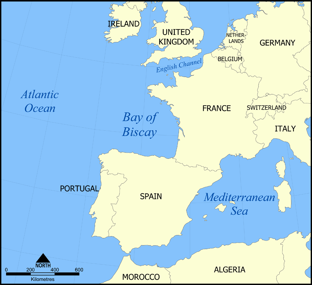
This is a map showing the location of the Bay of Biscay in the North Atlantic Ocean bordered on France and Spain. Created by NormanEinstein, November 7, 2005 {{GFDL-self}} Category:Maps of seas
ไฟล, biscay, ไฟล, ประว, ไฟล, หน, าท, ภาพน, การใช, ไฟล, วนกลาง, อม, ลเก, ยวก, บภาพขนาดของต, วอย, างน, กเซล, ความละเอ, ยดอ, กเซล, กเซล, กเซล, ภาพท, ความละเอ, ยดส, งกว, 8206, กเซล, ขนาดไฟล, โลไบต, ชน, ดไมม, image, ปภาพหร, อไฟล, เส, ยงน, นฉบ, บอย, คอมมอนส, รายละเอ. ifl prawtiifl hnathimiphaphni karichiflswnklang khxmulekiywkbphaphkhnadkhxngtwxyangni 657 600 phikesl khwamlaexiydxun 263 240 phikesl 526 480 phikesl 1 000 913 phikesl duphaphthimikhwamlaexiydsungkwa 8206 1 000 913 phikesl khnadifl 334 kiolibt chnidimm image png rupphaphhruxiflesiyngni tnchbbxyuthi khxmmxns raylaexiyddanlang epnkhxkhwamthiaesdngphlcak ifltnchbbinkhxmmxns khxmmxnsepnewbistinokhrngkarsahrbekbrwbrwmsuxesri thi khunsamarthchwyid khwamyx khaxthibayBay of Biscay map png English A map showing the location of the Bay of Biscay in the North Atlantic Ocean bordering on France and Spain Created by NormanEinstein November 7 2005 wnthi 7 phvscikayn ph s 2548 original upload date aehlngthima No machine readable source provided Own work assumed based on copyright claims phusrangsrrkh No machine readable author provided NormanEinstein assumed based on copyright claims karxnuyatichsiththi khapheca inthanaphuthuxlikhsiththikhxngphaphhruxsuxni xnuyatihichphaphhruxsuxniphayitenguxnikhtxipni xnuyatihkhdlxk aeckcayaela hruxddaeprexksarniphayitenguxnikhkhxngsyyaxnuyatexksaresrikhxngknu run 1 2 hruxrunid nbcaknithixxkodymulnithisxftaewresri odyimmiswnidhamaekikh immikhxkhwampkhnaaelapkhlng saenakhxngsyyaxnuyatrwmxyuinswnchux syyaxnuyatexksaresrikhxngknuhttp www gnu org copyleft fdl html GFDL GNU Free Documentation License true true iflnixyuphayitsyyaxnuyat khriexthifkhxmmxns aebbaesdngthima xnuyataebbediywkn 3 0 tnchbb khunsamarth thicaaebngpn thicathasaena aeckcay aelasngngandngklawtxip thicaeriyberiyngihm thicaddaeplngngandngklaw phayitenguxnikhtxipni aesdngthima khuntxngihekiyrtiecakhxngnganxyangehmaasm odyephimlingkipyngsyyaxnuyat aelarabuhakmikarepliynaeplng khunxacthaechnniidinrupaebbidkidtamkhwr aettxngimichinlksnathiaenawaphuihxnuyatsnbsnunkhunhruxkarichngankhxngkhun xnuyataebbediywkn hakkhunddaeplng epliynrup hruxtxetimnganni khuntxngichsyyaxnuyataebbediywknhruxaebbthiehmuxnkbsyyaxnuyatthiichkbnganniethann payaesdngsthanalikhsiththinithukephimephuxihepniptamkarepliynaeplngsyyaxnuyatkhxngmulnithiwikimiediy cak GFDL ipyng GFDL khwbkhukb CC BY SA 3 0 http creativecommons org licenses by sa 3 0 CC BY SA 3 0 Creative Commons Attribution Share Alike 3 0 true truekhunsamartheluxksyyaxnuyatdngklawtamtxngkar phaphnimiphaphinrupaebbewketxr SVG hakphaph SVG thaihkaraesdngphldikwa hnathiichphaphnikhwrepliynipichphaph SVG aethn File Bay of Biscay map png File Bay of Biscay map svg sahrbkhxmulephimetimekiywkbphaphewketxr duthi karepliynipichphaph SVG inkhxmmxnsnxkcaknisamarthduephimetimekiywkb khxmulekiywkbkarrxngrbphaph SVG sahrbsxftaewrmiediywiki id inphasaxun Alemannisch nbsp العربية nbsp belaruskaya tarashkevica nbsp blgarski nbsp ব ল nbsp catala nbsp nohchijn nbsp cestina nbsp dansk nbsp Deutsch nbsp Ellhnika nbsp English nbsp British English nbsp Esperanto nbsp espanol nbsp eesti nbsp euskara nbsp فارسی nbsp suomi nbsp francais nbsp Frysk nbsp galego nbsp עברית nbsp hrvatski nbsp magyar nbsp հայերեն nbsp Bahasa Indonesia nbsp Ido nbsp italiano nbsp 日本語 nbsp ქართული nbsp 한국어 nbsp lietuviu nbsp makedonski nbsp മലയ ള nbsp Bahasa Melayu nbsp norsk bokmal nbsp Plattduutsch nbsp Nederlands nbsp norsk nynorsk nbsp norsk nbsp occitan nbsp polski nbsp portugues nbsp portugues do Brasil nbsp romană nbsp russkij nbsp sicilianu nbsp Scots nbsp slovencina nbsp slovenscina nbsp srpski srpski nbsp svenska nbsp தம ழ nbsp ithy nbsp Turkce nbsp tatarcha tatarca nbsp ukrayinska nbsp veneto nbsp Tiếng Việt nbsp 中文 简体 nbsp 中文 繁體 nbsp nbsp khabrryayodyyxithyephimkhabrryaythrrthdediywephuxkhyaykhwamwaiflnimixairyuekhrnBiskajska zatoka na mapiixethmthiaesdngxyuiniflniprakxbdwysthanalikhsiththimilikhsiththisyyaxnuyatGNU Free Documentation License version 1 2 or later nbsp xngkvsCreative Commons Attribution ShareAlike 3 0 Unported nbsp xngkvs prawtiifl khlikwnthi ewlaephuxduiflthipraktinkhnann wnthi ewlarupyxkhnadphuichkhwamehn pccubn23 44 7 phvscikayn 25481 000 913 334 kiolibt NormanEinsteinThis is a map showing the location of the Bay of Biscay in the North Atlantic Ocean bordered on France and Spain Created by NormanEinstein November 7 2005 GFDL self Category Maps of seas hnathimiphaphni hnatxipni oyngmathiphaphni xawbisekhy karichiflswnklang wikixuntxipniichiflni karichbn af wikipedia org Golf van Biskaje karichbn an wikipedia org Golfo de Bizcaya karichbn ar wikipedia org الخطوط البريطانية عبر البحار الرحلة 777 تمرين فيريتي karichbn arz wikipedia org خليج بسكاى karichbn azb wikipedia org بیسکای کؤرفزی karichbn az wikipedia org Biskay korfezi karichbn bn wikipedia org ব স ক য উপস গর karichbn el wikipedia org Biskaikos kolpos karichbn el wiktionary org Biskaikos kolpos karichbn en wikipedia org Leslie Howard User NormanEinstein gallery Prestige oil spill Exercise Verity User Lord Cornwallis Western Squadron Operation Turkey Buzzard karichbn en wikinews org Two nuclear submarines collide in the Atlantic Ocean karichbn en wiktionary org golfe de Gascogne karichbn eo wikipedia org Biskaja Golfo karichbn es wikipedia org Golfo de Vizcaya karichbn fi wikipedia org M S Notos karichbn fo wikipedia org Biscayaflogvin karichbn fr wikipedia org Utilisateur Pline creation article karichbn fy wikipedia org Golf fan Biskaje karichbn gl wikipedia org Golfo de Biscaia karichbn hi wikipedia org ब स क क ख ड karichbn id wikipedia org Teluk Biscay karichbn is wikipedia org Biskajafloi karichbn it wikipedia org Golfo di Biscaglia Operazione Turkey Buzzard karichbn ka wikipedia org ბისკაიის ყურე karichbn ko wikipedia org 비스케이만 karichbn la wikipedia org Sinus Cantabricus karichbn li wikipedia org Golf van Biskaje karichbn nn wikipedia org Biscayabukta karichbn no wikipedia org Biscayabukten karichbn oc wikipedia org Golf de Gasconha karichbn pa wikipedia org ਬ ਸਕ ਦ ਖ ੜ karichbn pl wikipedia org Operacja Turkey Buzzard karichbn pl wiktionary org Bay of Biscay Zatoka Biskajska Biskajsky zaliv Biskajski zaliv Biskajski zaliy Biskajas licis karichbn pnb wikipedia org خلیج بسکے karichbn simple wikipedia org Bay of Biscay karichbn sk wikipedia org Biskajsky zaliv karichbn sl wikipedia org Biskajski zaliv karichbn sv wikipedia org Biscayabukten dukarichthwolkephimetimkhxngiflnikhxmulekiywkbphaph phaphnimikhxmulephimetim sungswnihymacakklxngdicitxlhruxsaeknenxrthisamarthekbkhxmuldngklawiwrwmkbphaphid thaphaphnithukprbprungaekikhhruxepliynaeplngcakedim khxmulbangxyangcayngkhngimepliynaeplngehmuxnphaphthithukprbprungaekikhnnkhwamlaexiydaenwnxn28 35 dpckhwamlaexiydaenwtng28 35 dpc ekhathungcak https th wikipedia org wiki ifl Bay of Biscay map png, wikipedia, วิกิ หนังสือ, หนังสือ, ห้องสมุด,