https://creativecommons.org/publicdomain/mark/1.0/PDMCreative Commons Public Domain Mark 1.0falsefalse
เวอร์ชันอื่น
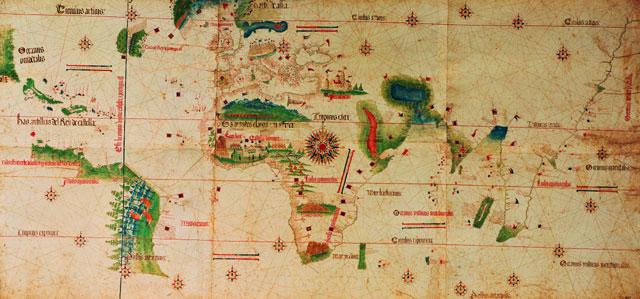
Image is 500 years old, not subject to copyright
This file has been superseded by CantinoPlanisphere.png. It is recommended to use the other file. Please note that deleting superseded images requires consent.
{{Information |Description=Cantino planisphere, map of XV Century. |Source=Taken from English wikipedia at [http://en.wikipedia.org/wiki/Image:Cantino_Planisphere.jpg], found originally at [http://www.ac-creteil.fr/portugais/PPCANTINO2.jpg] |Date= |Author
ไฟล, cantino, planisphere, ไฟล, ประว, ไฟล, หน, าท, ภาพน, การใช, ไฟล, วนกลางไม, ภาพท, รายละเอ, ยดส, งกว, าน, cantino, planisphere, 8206, กเซล, ขนาดไฟล, โลไบต, ชน, ดไมม, image, jpeg, ปภาพหร, อไฟล, เส, ยงน, นฉบ, บอย, คอมมอนส, รายละเอ, ยดด, านล, าง, เป, นข, อความท. ifl prawtiifl hnathimiphaphni karichiflswnklangimmiphaphthimiraylaexiydsungkwani Cantino Planisphere jpg 8206 640 299 phikesl khnadifl 44 kiolibt chnidimm image jpeg rupphaphhruxiflesiyngni tnchbbxyuthi khxmmxns raylaexiyddanlang epnkhxkhwamthiaesdngphlcak ifltnchbbinkhxmmxns khxmmxnsepnewbistinokhrngkarsahrbekbrwbrwmsuxesri thi khunsamarthchwyid khaxthibayCantino Planisphere jpg Cantino planisphere map of XV Century wnthi 2044 hrux 2045 rarely said 1503 aehlngthima Taken from English wikipedia at 1 found originally at 2 phusrangsrrkh phaphhruxsuxnikhadkhxmulekiywkb phusrangsrrkhphlngankarxnuyat karichiflniihm Public domain Public domain false falsenganniepnsatharnsmbti inpraethstnkaenidaelapraethsxun thirayaewlakarkhumkhrxnglikhsiththinxykwa 100 pihlngcakphusrangsrrkhnganesiychiwit nxkcaknikhunxactxngephimpaysatharnsmbtiinshrthxemrika ephuxrabuwaehtuidngannicungepnsatharnsmbtiinshrthxemrikaiflniidthukrabuwaimmikhxcakdphayitkdhmaylikhsiththi rwmthungsiththithiekiywkhxngaelathiiklekhiyngknhttps creativecommons org publicdomain mark 1 0 PDM Creative Commons Public Domain Mark 1 0 false falseewxrchnxun Image is 500 years old not subject to copyright This file has been superseded by CantinoPlanisphere png It is recommended to use the other file Please note that deleting superseded images requires consent khabrryayodyyxithyephimkhabrryaythrrthdediywephuxkhyaykhwamwaiflnimixairepxresiyصفحه کره کانتینو نقشه قرن پانزدهم ixethmthiaesdngxyuiniflniprakxbdwy prawtiifl khlikwnthi ewlaephuxduiflthipraktinkhnann wnthi ewlarupyxkhnadphuichkhwamehn pccubn13 36 1 thnwakhm 2549640 299 44 kiolibt Sergio commonswiki Information Description Cantino planisphere map of XV Century Source Taken from English wikipedia at http en wikipedia org wiki Image Cantino Planisphere jpg found originally at http www ac creteil fr portugais PPCANTINO2 jpg Date Author hnathimiphaphni hnatxipni oyngmathiphaphni yukhaehngkarsarwc karichiflswnklang wikixuntxipniichiflni karichbn azb wikipedia org اوروپا تاریخی karichbn bg wikipedia org Geografiya Veliki geografski otkritiya Kartografiya karichbn ca wikipedia org Amerigo Vespucci karichbn en wikipedia org User Walrasiad Ramusio User Peter Mercator Map gallery karichbn eo wikipedia org Epoko de Malkovroj karichbn es wikipedia org Usuario Hispalois mapas antiguos Historia de la cartografia karichbn et wikipedia org Varauusaeg karichbn fa wikipedia org جغرافیا نقشه های کهن تاریخ جغرافیا karichbn fr wikipedia org 1502 1494 Decouvertes portugaises karichbn he wikipedia org האימפריה הפורטוגזית עידן התגליות karichbn hy wikipedia org Եվրոպայի պատմություն karichbn id wikipedia org Abad Penjelajahan karichbn it wikipedia org Utente Anonimo88 Sandbox2 karichbn ja wikipedia org トルデシリャス 初期の世界地図 karichbn ko wikipedia org 토르데시야스 karichbn la wikipedia org Historia Europae karichbn mk wikipedia org Vikipediјa Kandidati za izbrana statiјa Golemite geografski otkritiјa Ran nov vek karichbn mwl wikipedia org Ccubrimientos pertueses karichbn nl wikipedia org Portugese ontdekkingsreizen en het Portugese Rijk karichbn pt wikipedia org Descobrimentos portugueses Tratado de Tordesilhas Usuario a Casadopovo Eurafrica karichbn sl wikipedia org Zgodnji zemljevidi sveta karichbn sv wikipedia org Tidigmoderna tiden karichbn tr wikipedia org Tordesillas Antlasmasi 1421 kitap karichbn uk wikipedia org Rannij novij period ekhathungcak https th wikipedia org wiki ifl Cantino Planisphere jpg, wikipedia, วิกิ หนังสือ, หนังสือ, ห้องสมุด,
![[2]](http://www.ac-creteil.fr/portugais/PPCANTINO2.jpg)