https://creativecommons.org/licenses/by/3.0CC BY 3.0 Creative Commons Attribution 3.0 truetrue
This map is part of a collection of 216 free country maps, created by the UN Office for the Coordination of Humanitarian Affairs (OCHA), to be used in print, web or broadcast products.
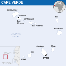
The ReliefWeb Location Maps released here are maps that highlight a country, its capital, major populated places and the surrounding regions.
Attribution Requirements
Using the map without modifications: ensure that the sources and the disclaimer are below the map. Credit as follows: "Credit: OCHA".
For use with alteration: remove the OCHA logo and disclaimer following any modification to the map, but keep the data sources as mentioned below the map. Credit the modified map as follows: "Based on OCHA map". You are responsible for the content of your map.
We are keen to receive your feedback and hear how you used OCHA's maps. We would be grateful if you would notify us by e-mail and share your work with us.
UN Disclaimer
The designations employed and the presentation of material of this map do not imply the expression of any opinion whatsoever on the part of the Secretariat of the United Nations concerning the legal status of any country, territory, city or area or of its authorities or concerning the delimitation of its frontiers or boundaries.
ไฟล, cape, verde, location, 2013, unocha, ไฟล, ประว, ไฟล, หน, าท, ภาพน, การใช, ไฟล, วนกลาง, อม, ลเก, ยวก, บภาพขนาดของต, วอย, าง, ของไฟล, กเซล, ความละเอ, ยดอ, กเซล, กเซล, กเซล, กเซล, กเซล, ภาพท, ความละเอ, ยดส, งกว, 8206, ไฟล, กเซล, ขนาดไฟล, โลไบต, เรนเดอร, ภาพน. ifl prawtiifl hnathimiphaphni karichiflswnklang khxmulekiywkbphaphkhnadkhxngtwxyang PNG nikhxngifl SVG ni 250 250 phikesl khwamlaexiydxun 240 240 phikesl 480 480 phikesl 768 768 phikesl 1 024 1 024 phikesl 2 048 2 048 phikesl duphaphthimikhwamlaexiydsungkwa 8206 ifl SVG 250 250 phikesl khnadifl 350 kiolibt ernedxrphaphniin xinodniesiy id phasaodypriyay rupphaphhruxiflesiyngni tnchbbxyuthi khxmmxns raylaexiyddanlang epnkhxkhwamthiaesdngphlcak ifltnchbbinkhxmmxns khxmmxnsepnewbistinokhrngkarsahrbekbrwbrwmsuxesri thi khunsamarthchwyid khwamyx khaxthibayCape Verde Location Map 2013 CPV UNOCHA svg English Locator map of Cape Verde wnthi ph s 2556aehlngthima English Cabo Verde Locator Map ReliefWeb ESRI UNCSphusrangsrrkh English UN Office for the Coordination of Humanitarian Affairs OCHA SVG genesisInfoField sxrsokhdkhxng SVG nitrwcsxbthuktxngaelw iflphaphkrafiksewketxrni srangkhunodyich Inkscape This map uses embedded text that can be easily translated using a text editor karxnuyatichsiththi iflnixyuphayitsyyaxnuyatkhriexthifkhxmmxns run aesdngthima 3 0 tnchbbkaraesdngthima OCHAkhunsamarth thicaaebngpn thicathasaena aeckcay aelasngngandngklawtxip thicaeriyberiyngihm thicaddaeplngngandngklaw phayitenguxnikhtxipni aesdngthima khuntxngihekiyrtiecakhxngnganxyangehmaasm odyephimlingkipyngsyyaxnuyat aelarabuhakmikarepliynaeplng khunxacthaechnniidinrupaebbidkidtamkhwr aettxngimichinlksnathiaenawaphuihxnuyatsnbsnunkhunhruxkarichngankhxngkhunhttps creativecommons org licenses by 3 0 CC BY 3 0 Creative Commons Attribution 3 0 true true This map is part of a collection of 216 free country maps created by the UN Office for the Coordination of Humanitarian Affairs OCHA to be used in print web or broadcast products The ReliefWeb Location Maps released here are maps that highlight a country its capital major populated places and the surrounding regions Attribution Requirements Using the map without modifications ensure that the sources and the disclaimer are below the map Credit as follows Credit OCHA For use with alteration remove the OCHA logo and disclaimer following any modification to the map but keep the data sources as mentioned below the map Credit the modified map as follows Based on OCHA map You are responsible for the content of your map We are keen to receive your feedback and hear how you used OCHA s maps We would be grateful if you would notify us by e mail and share your work with us UN Disclaimer The designations employed and the presentation of material of this map do not imply the expression of any opinion whatsoever on the part of the Secretariat of the United Nations concerning the legal status of any country territory city or area or of its authorities or concerning the delimitation of its frontiers or boundaries khxkhwamxnuyatcakecakhxnglikhsiththiihichnganphaphhruxsuxni idrbkartrwcsxbaelw aelathukekbiwinxasasmkhrtxbklbxieml VRT odysahrbphuichthimibychi VRT samarthtrwcsxbbnthukekiywkbkhxkhwamxnuyatnnid inbnthukhmayelkh 2014031410007248 hakthantxngkarnaphaphhruxsuxniipichthixunnxkehnuxcakinmulnithiwikimiediy krunaxankhxmulekiywkbkarnaenuxhaipichnxkmulnithiwikimiediythihnani thngnihakthanprasngkhcakhxkhayunynekiywkbkarxnuyatihichichphaphhruxsuxni krunatidtxphuichthimibychi VRT hruxaecngphanhnaaecng VRT lingkkhxngbnthuk https ticket wikimedia org otrs index pl Action AgentTicketZoom amp TicketNumber 2014031410007248 Find other files from the same ticket khabrryayodyyxithyephimkhabrryaythrrthdediywephuxkhyaykhwamwaiflnimixairixethmthiaesdngxyuiniflniprakxbdwysthanalikhsiththimilikhsiththisyyaxnuyatCreative Commons Attribution 3 0 Unported xngkvsWikimedia VRTS ticket number xngkvs2014031410007248wnthisrang wnkxtng2013 prawtiifl khlikwnthi ewlaephuxduiflthipraktinkhnann wnthi ewlarupyxkhnadphuichkhwamehn pccubn11 23 19 phvscikayn 2565250 250 350 kiolibt Pengetik AMFile uploaded using svgtranslate tool https svgtranslate toolforge org Added translation for id 15 07 22 mkrakhm 2559250 250 349 kiolibt Wereldburger758Resized page to drawing Removal watermark Validation of image 11 00 18 emsayn 2557254 254 371 kiolibt UN OCHA maps bot int filedesc Information description en 1 Locator Map of Cape Verde OCHA map date 2013 source en 1 http reliefweb int map cape verde cape verde location map 2013 Cabo Verde Locator Map ReliefWeb au hnathimiphaphni hnatxipni oyngmathiphaphni praethskabuewrdi karichiflswnklang wikixuntxipniichiflni karichbn en wikipedia org Action of 4 April 1941 History of the Jews in Cape Verde karichbn id wikipedia org Tanjung Verde Templat Tanjung Verde infobox karichbn mdf wikipedia org Kabo Verdekhxmulekiywkbphaph phaphnimikhxmulephimetim sungswnihymacakklxngdicitxlhruxsaeknenxrthisamarthekbkhxmuldngklawiwrwmkbphaphid thaphaphnithukprbprungaekikhhruxepliynaeplngcakedim khxmulbangxyangcayngkhngimepliynaeplngehmuxnphaphthithukprbprungaekikhnnkhwamkwang250 3125khwamsung250 3125 ekhathungcak https th wikipedia org wiki ifl Cape Verde Location Map 2013 CPV UNOCHA svg, wikipedia, วิกิ หนังสือ, หนังสือ, ห้องสมุด,