ดูภาพที่มีความละเอียดสูงกว่า ((ไฟล์ SVG, 550 × 550 พิกเซล, ขนาดไฟล์: 844 กิโลไบต์))
ความย่อ
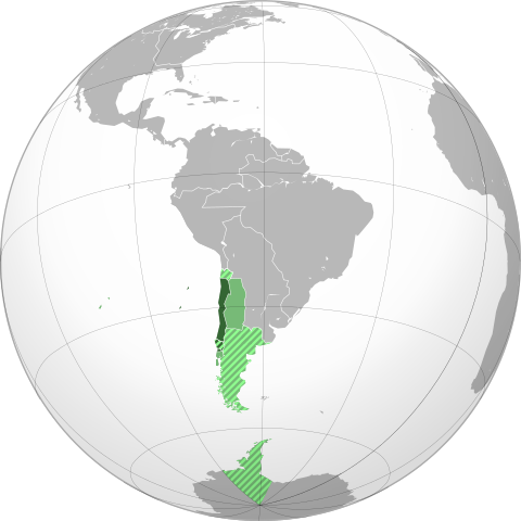
| คำอธิบายCaptaincy General of Chile (orthographic projection).svg | English: Approximate extension of the Captaincy General of Chile🔅 in orthographic projection. Español: Ubicación geográfica aproximada de la Capitanía General de Chile🔅 en proyección ortográfica. | ||||
| วันที่ | |||||
| แหล่งที่มา | Own work based on: the Brazil (orthographic projection).svg, created by the Wikimedia Commons user Ssolbergj, under a Creative Commons Licence. Boundaries based in the following sources:
| ||||
| ผู้สร้างสรรค์ | B1mbo | ||||
| การอนุญาต (การใช้ไฟล์นี้ใหม่) | ข้าพเจ้า ในฐานะผู้ถือลิขสิทธิ์ของภาพหรือสื่อนี้ อนุญาตให้ใช้ภาพหรือสื่อนี้ภายใต้เงื่อนไขต่อไปนี้ ไฟล์นี้อยู่ภายใต้สัญญาอนุญาตครีเอทีฟคอมมอนส์ รุ่น แสดงที่มา 3.0 ต้นฉบับ
| ||||
| เวอร์ชันอื่น | This is a Grey & green orthographic projection map.
العربية: الرجاء، قراءة الميثاق. বাংলা: দয়া করে, রীতিনীতিটি পড়ুন। Deutsch: Bitte lies die Konventionen. English: Please, read the conventions. Español: Por favor, lea las convenciones. Filipino: Paki-basa ang mga kumbensyon. Français : S'il vous plaît, lisez les conventions. हिन्दी: कृपया सभागमों को पढ़ लें. Bahasa Indonesia: Silakan, baca konvensi. Italiano: Si prega di leggere le convenzioni. 日本語: 規約をご確認ください。 ქართული: გთხოვთ, გაეცნოთ კონვენციებს. Македонски: Ве молиме, прочитајте ги општоприфатените правила. Português: Por favor, leia as convenções. Русский: Пожалуйста, прочитайте соглашения. Tagalog: Paki-basa ang mga kumbensyon. Українська: Будь ласка, прочитайте конвенції. Tiếng Việt: Hãy đọc công văn trước khi đăng.
| ||||
| SVG genesis InfoField | ซอร์สโค้ดของ SVG นี้ตรวจสอบถูกต้องแล้ว ไฟล์ภาพกราฟิกส์เวกเตอร์นี้ สร้างขึ้นโดยใช้ Inkscape
|
คำบรรยายโดยย่อ
ไอเทมที่แสดงอยู่ในไฟล์นี้
ประกอบด้วย
ผู้สร้าง
บางค่าที่ไม่มีไอเทมวิกิสนเทศ
สถานะลิขสิทธิ์
มีลิขสิทธิ์
สัญญาอนุญาต
Creative Commons Attribution 3.0 Unported อังกฤษ
วันที่สร้าง/วันก่อตั้ง
20 มิถุนายน 2010
MIME type อังกฤษ
image/svg+xml
ประวัติไฟล์
คลิกวันที่/เวลาเพื่อดูไฟล์ที่ปรากฏในขณะนั้น
| วันที่/เวลา | รูปย่อ | ขนาด | ผู้ใช้ | ความเห็น | |
|---|---|---|---|---|---|
| ปัจจุบัน | 02:36, 8 พฤศจิกายน 2565 | 550 × 550 (844 กิโลไบต์) | Janitoalevic | Borders bases on the Map of Cano y Olmedilla of 1775 | |
| 23:54, 18 ตุลาคม 2565 | 550 × 550 (373 กิโลไบต์) | Janitoalevic | Added Terra Australis (1555) and Easter Island (1770) | ||
| 05:37, 8 กรกฎาคม 2565 | 550 × 550 (364 กิโลไบต์) | Janitoalevic | límite en el río Loa entre la prov. de Santiago y Arequipa (Eyzaguirre, Jaime, 1967) | ||
| 05:11, 20 กันยายน 2562 | 550 × 550 (253 กิโลไบต์) | B1mbo | Correcciones | ||
| 00:00, 11 กรกฎาคม 2555 | 550 × 550 (139 กิโลไบต์) | Jespinos | Reverted to version as of 16:58, 10 July 2012 | ||
| 23:58, 10 กรกฎาคม 2555 | 550 × 550 (150 กิโลไบต์) | Jespinos | Reverted to version as of 09:07, 26 May 2012 | ||
| 23:58, 10 กรกฎาคม 2555 | 550 × 550 (139 กิโลไบต์) | Jespinos | Reverted to version as of 23:27, 20 June 2010 | ||
| 16:07, 26 พฤษภาคม 2555 | 550 × 550 (150 กิโลไบต์) | Franco-eisenhower | Límite verdadero Patagonia: http://www.scielo.cl/scielo.php?pid=S0717-71942002003500009&script=sci_arttext&tlng=es | ||
| 06:27, 21 มิถุนายน 2553 | 550 × 550 (139 กิโลไบต์) | B1mbo | == Summary == {{created with Inkscape}} {{Information |Description= {{en|Location of the Captaincy General of Chile in orthographic projection, approx. 1796. {{legend|DarkGreen|Sovereign territory.}} {{legend|Lime|Terr |
หน้าที่มีภาพนี้
หน้าต่อไปนี้ โยงมาที่ภาพนี้:
การใช้ไฟล์ส่วนกลาง
วิกิอื่นต่อไปนี้ใช้ไฟล์นี้:
ข้อมูลเกี่ยวกับภาพ
ภาพนี้มีข้อมูลเพิ่มเติม ซึ่งส่วนใหญ่มาจากกล้องดิจิตอลหรือสแกนเนอร์ที่สามารถเก็บข้อมูลดังกล่าวไว้รวมกับภาพได้ ถ้าภาพนี้ถูกปรับปรุงแก้ไขหรือเปลี่ยนแปลงจากเดิม ข้อมูลบางอย่างจะยังคงไม่เปลี่ยนแปลงเหมือนภาพที่ถูกปรับปรุงแก้ไขนั้น
| ความกว้าง | 550 |
|---|---|
| ความสูง | 550.00024 |