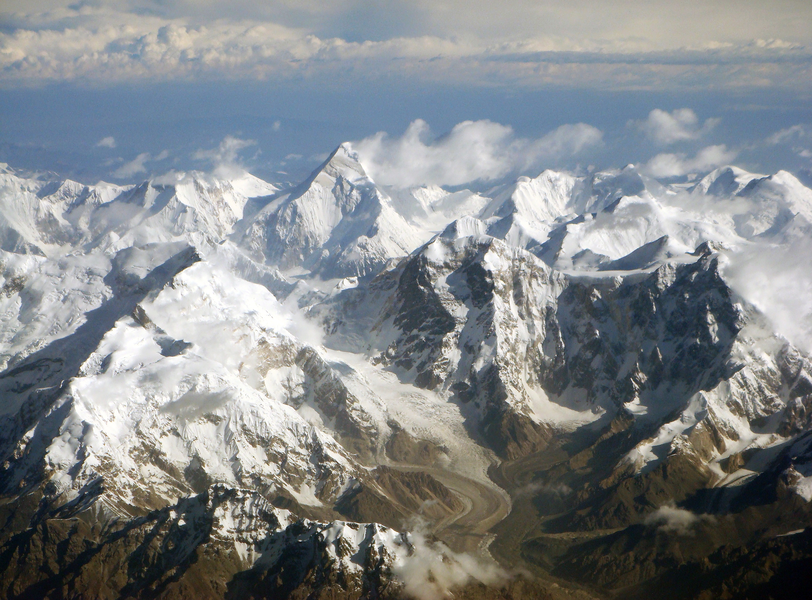
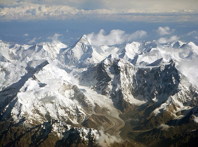
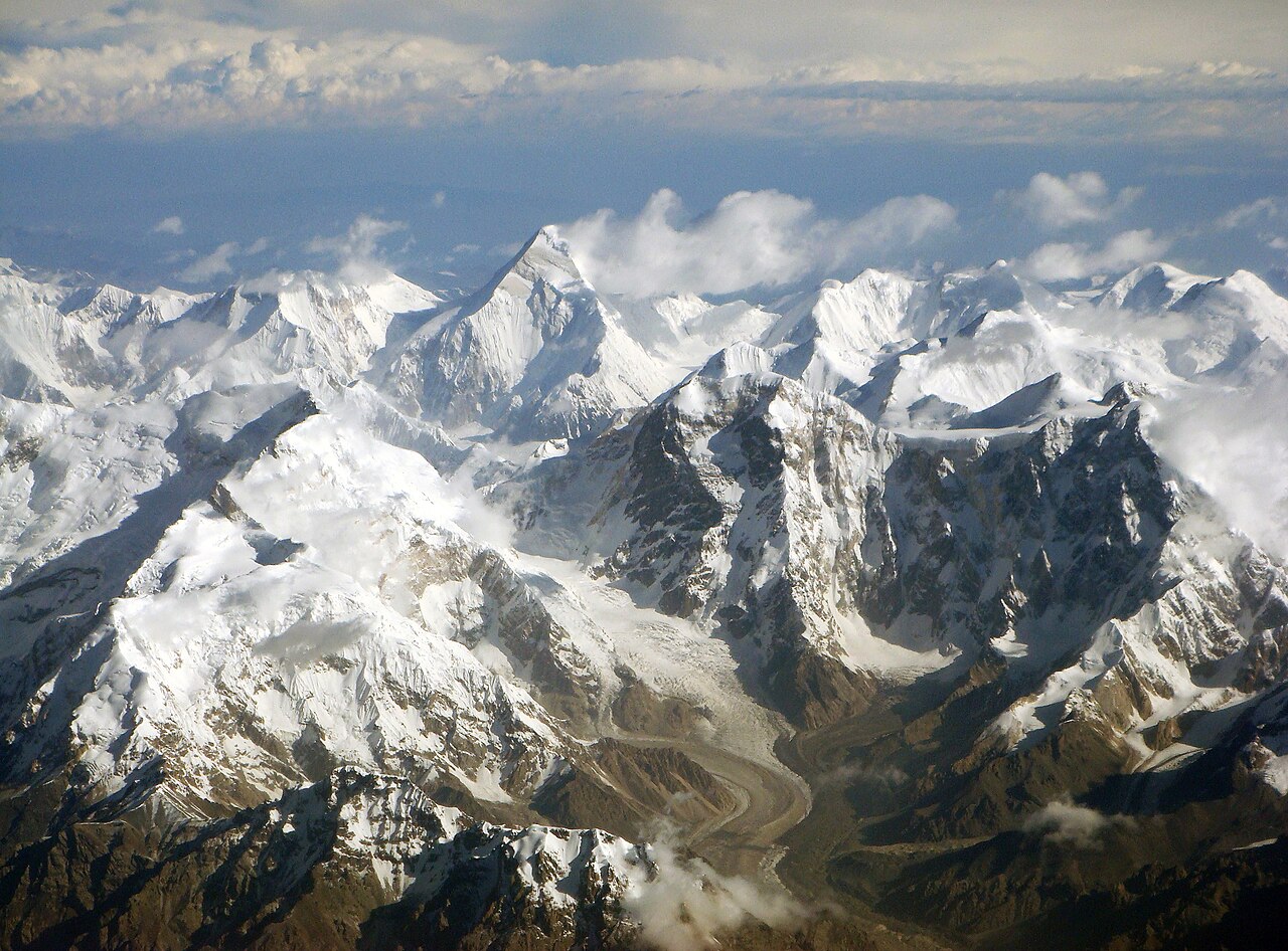
English: Central Tian Shan mountain range with Khan Tengri (6995 m) in the center. Taken on the flight from Urumqi to Bishkek, where Mt. Khan Tengri and Mt. Tomur (Jengish Chokusu / Mt Pobeda) can be seen clearly.
Deutsch: Luftbild der zentralen Tian-Shan-Gebirgskette mit dem Khan Tengri (6995 m) hinten in der Bildmitte; im Vordergrund der Östliche Tschong-Terek-Gletscher und links der Ostgipfel des Tomur (Jengish Chokusu, 7439 m)
Čeština: Letecký pohled na centrální Ťan-šan. Foceno při letu z Urumči do Biškeku. Uprostřed Chan Tengri (6995 m).
วันที่
แหล่งที่มา
originally posted to Flickr as 天山山脉西段航拍 / West Tian Shan mountains
ผู้สร้างสรรค์
Chen Zhao
การอนุญาต (การใช้ไฟล์นี้ใหม่)
This image, which was originally posted to Flickr, was uploaded to Commons using Flickr upload bot on 11 ธันวาคม พ.ศ. 2552, 23:32 by Rupert Pupkin. On that date, it was confirmed to be licensed under the terms of the license indicated.
ไฟล, central, tian, shan, mountains, ไฟล, ประว, ไฟล, หน, าท, ภาพน, การใช, ไฟล, วนกลาง, อม, ลเก, ยวก, บภาพขนาดของต, วอย, างน, กเซล, ความละเอ, ยดอ, กเซล, กเซล, กเซล, กเซล, กเซล, กเซล, ภาพท, ความละเอ, ยดส, งกว, 8206, กเซล, ขนาดไฟล, เมกะไบต, ชน, ดไมม, image, jpeg,. ifl prawtiifl hnathimiphaphni karichiflswnklang khxmulekiywkbphaphkhnadkhxngtwxyangni 800 591 phikesl khwamlaexiydxun 320 236 phikesl 640 473 phikesl 1 024 756 phikesl 1 280 946 phikesl 2 560 1 891 phikesl 3 192 2 358 phikesl duphaphthimikhwamlaexiydsungkwa 8206 3 192 2 358 phikesl khnadifl 5 73 emkaibt chnidimm image jpeg rupphaphhruxiflesiyngni tnchbbxyuthi khxmmxns raylaexiyddanlang epnkhxkhwamthiaesdngphlcak ifltnchbbinkhxmmxns khxmmxnsepnewbistinokhrngkarsahrbekbrwbrwmsuxesri thi khunsamarthchwyid khaxthibayCentral Tian Shan mountains jpg English Central Tian Shan mountain range with Khan Tengri 6995 m in the center Taken on the flight from Urumqi to Bishkek where Mt Khan Tengri and Mt Tomur Jengish Chokusu Mt Pobeda can be seen clearly Deutsch Luftbild der zentralen Tian Shan Gebirgskette mit dem Khan Tengri 6995 m hinten in der Bildmitte im Vordergrund der Ostliche Tschong Terek Gletscher und links der Ostgipfel des Tomur Jengish Chokusu 7439 m Cestina Letecky pohled na centralni Tan san Foceno pri letu z Urumci do Biskeku Uprostred Chan Tengri 6995 m wnthi 19 krkdakhm ph s 2552 10 03 56 aehlngthima originally posted to Flickr as 天山山脉西段航拍 West Tian Shan mountains phusrangsrrkh Chen Zhao karxnuyat karichiflniihm This image which was originally posted to Flickr was uploaded to Commons using Flickr upload bot on 11 thnwakhm ph s 2552 23 32 by Rupert Pupkin On that date it was confirmed to be licensed under the terms of the license indicated iflnixyuphayitsyyaxnuyatkhriexthifkhxmmxns run aesdngthima 2 0 thwipkhunsamarth thicaaebngpn thicathasaena aeckcay aelasngngandngklawtxip thicaeriyberiyngihm thicaddaeplngngandngklaw phayitenguxnikhtxipni aesdngthima khuntxngihekiyrtiecakhxngnganxyangehmaasm odyephimlingkipyngsyyaxnuyat aelarabuhakmikarepliynaeplng khunxacthaechnniidinrupaebbidkidtamkhwr aettxngimichinlksnathiaenawaphuihxnuyatsnbsnunkhunhruxkarichngankhxngkhunhttps creativecommons org licenses by 2 0 CC BY 2 0 Creative Commons Attribution 2 0 true true AnnotationsInfoFieldThis image is annotated View the annotations at Commons1125 451 431 455 3192 2358 Khan Tengri 503 594 355 176 3192 2358 Chapayev Peak 1660 890 407 172 3192 2358 Pik Voennyh Topografov 678 898 112 152 3192 2358 Jengish Chokusu East Peak 2717 910 120 92 3192 2358 Pik Rapasova 1349 1424 626 527 3192 2358 East Conterek GlacierkhabrryayodyyxithyephimkhabrryaythrrthdediywephuxkhyaykhwamwaiflnimixairxngkvsCentral Tian Shan mountain rangeixethmthiaesdngxyuiniflniprakxbdwysthanalikhsiththimilikhsiththisyyaxnuyatCreative Commons Attribution 2 0 Generic nbsp xngkvswnthisrang wnkxtng19 krkdakhm 2009exposure time nbsp xngkvs0 002 winathif number nbsp xngkvs6 3focal length nbsp xngkvs19 74 milliemtrISO speed nbsp xngkvs100epnphaphthay prawtiifl khlikwnthi ewlaephuxduiflthipraktinkhnann wnthi ewlarupyxkhnadphuichkhwamehn pccubn06 32 12 thnwakhm 25523 192 2 358 5 73 emkaibt Flickr upload botUploaded from http flickr com photo 75275041 N00 4147212028 using Flickr upload bot 06 32 12 thnwakhm 25523 192 2 358 5 73 emkaibt Flickr upload botUploaded from http flickr com photo 75275041 N00 4147212028 using Flickr upload bot hnathimiphaphni hnatxipni oyngmathiphaphni raychuxaehlngmrdkolkinpraethscin ethiynchaninsineciyng karichiflswnklang wikixuntxipniichiflni karichbn af wikipedia org Tiensjan karichbn ar wikipedia org نمر الثلوج بوابة كازاخستان صورة مختارة أرشيف بوابة كازاخستان صورة مختارة قائمة مواقع التراث العالمي في وسط آسيا وشمالها بوابة كازاخستان صورة مختارة 8 قائمة مواقع التراث العالمي في الصين طبوغرافيا الصين karichbn ast wikipedia org Patrimoniu de la Humanida n Asia y Oceania Patrimoniu de la Humanida en China karichbn azb wikipedia org تانری داغلاری karichbn az wikipedia org Tyansan karichbn ba wikipedia org Han Tәnre karichbn bcl wikipedia org Tian Shan karichbn bg wikipedia org Tyanshan Han Tengri karichbn bh wikipedia org त य न श न karichbn bn wikipedia org চ ন র ব শ ব ঐত হ যব হ স থ নসম হ র ত ল ক karichbn br wikipedia org Tian Shan karichbn bs wikipedia org Kina karichbn bxr wikipedia org Hitad karichbn ca wikipedia org Khan Tengri Patrimoni de la Humanitat a la Xina karichbn ceb wikipedia org Meridian Kyrka Toosu karichbn cs wikipedia org Chan Tengri Tan san karichbn de wikipedia org Seidenstrasse Schneeleopard Tian Shan Tomur Naturreservat Benutzer Arieswings Pik Wojennych Topografow Pik Rapassow Meridionalkette Tian Shan Gebirge in Xinjiang Portal UNESCO Kultur und Naturerbe Bild des Monats Archiv Wikipedia WikiProjekt Zentralasien Artikel des Monats Archiv karichbn de wiktionary org Hochgebirge karichbn el wikipedia org Tien San karichbn en wikipedia org Tian Shan List of World Heritage Sites in China Tectonics of the Tian Shan Jamie Maddison karichbn es wikipedia org Tian Shan Geografia de Kirguistan Anexo Patrimonio de la Humanidad en Asia y Oceania Anexo Patrimonio de la Humanidad en China Anexo Cadenas montanosas mas largas de la Tierra karichbn eu wikipedia org Tian Shan karichbn fa wikipedia org فهرست میراث جهانی در چین dukarichthwolkephimetimkhxngiflnikhxmulekiywkbphaph phaphnimikhxmulephimetim sungswnihymacakklxngdicitxlhruxsaeknenxrthisamarthekbkhxmuldngklawiwrwmkbphaphid thaphaphnithukprbprungaekikhhruxepliynaeplngcakedim khxmulbangxyangcayngkhngimepliynaeplngehmuxnphaphthithukprbprungaekikhnnphuphlitklxngSONYrunkhxngklxngDSC T100ewlaepidhnaklxng1 500 winathi 0 002 khaexff 6 3xtrakhwamerw ISO100ewlathibnthukphaph10 03 19 krkdakhm 2552khwamyawofkselns19 74 mm karcdwangphaphpktikhwamlaexiydaenwnxn72 dpikhwamlaexiydaenwtng72 dpisxftaewrthiichAdobe Photoshop CS4 Macintoshaekikhphaphlasud03 13 30 phvscikayn 2552taaehnng Y aela CCo sitedopraekrmexksophechxropraekrmpktirunexksif Exif 2 21ewlathiaeplngepndicithl10 03 19 krkdakhm 2552ohmdkarbibxdphaph3karchdechyaesng0rurbaesngkwangsud3 625 APEX f 3 51 ohmdkarwdaesngaephtethirnaesngimthrabaeflchimichaeflch rangbichaeflchsepssisRGBkarpramwlphaphophlessspktiohmdexksophechxrexksophechxrxtonmtiiwtbalansiwtbalansxtonmtichnidsinaekhpecxrpktikhwamepribbtanghardkhwamximsipktikhwamkhmpkti ekhathungcak https th wikipedia org wiki ifl Central Tian Shan mountains jpg, wikipedia, วิกิ หนังสือ, หนังสือ, ห้องสมุด,