รูปภาพหรือไฟล์เสียงนี้ ต้นฉบับอยู่ที่ คอมมอนส์ รายละเอียดด้านล่าง เป็นข้อความที่แสดงผลจาก ไฟล์ต้นฉบับในคอมมอนส์ คอมมอนส์เป็นเว็บไซต์ในโครงการสำหรับเก็บรวบรวมสื่อเสรี ที่ คุณสามารถช่วยได้
คำอธิบายChile.estrechodemagallanes.png Strait of Magellan, Chile วันที่ พ.ศ. 2551 แหล่งที่มา งานของตัว ผู้สร้างสรรค์ Createaccount การอนุญาต(การใช้ไฟล์นี้ใหม่)
বাংলা ∙ English ∙ español ∙ français ∙ italiano ∙ 日本語 ∙ македонски ∙ sicilianu ∙ 中文(简体) ∙ 中文(繁體) ∙ +/−
อนุญาตให้คัดลอก แจกจ่ายและ/หรือดัดแปรเอกสารนี้ภายใต้เงื่อนไขของสัญญาอนุญาตเอกสารเสรีของกนู รุ่น 1.2 หรือรุ่นใด ๆ นับจากนี้ที่ออกโดยมูลนิธิซอฟต์แวร์เสรี โดยไม่มีส่วนใดห้ามแก้ไข ไม่มีข้อความปกหน้าและปกหลัง สำเนาของสัญญาอนุญาตรวมอยู่ในส่วนชื่อ สัญญาอนุญาตเอกสารเสรีของกนู http://www.gnu.org/copyleft/fdl.html GFDL GNU Free Documentation License true true
ไฟล์นี้อยู่ภายใต้สัญญาอนุญาต ครีเอทีฟคอมมอนส์ แบบแสดงที่มา-อนุญาตแบบเดียวกัน 3.0 ต้นฉบับ คุณสามารถ: ที่จะแบ่งปัน – ที่จะทำสำเนา แจกจ่าย และส่งงานดังกล่าวต่อไปที่จะเรียบเรียงใหม่ – ที่จะดัดแปลงงานดังกล่าว ภายใต้เงื่อนไขต่อไปนี้: แสดงที่มา – คุณต้องให้เกียรติเจ้าของงานอย่างเหมาะสม โดยเพิ่มลิงก์ไปยังสัญญาอนุญาต และระบุหากมีการเปลี่ยนแปลง คุณอาจทำเช่นนี้ได้ในรูปแบบใดก็ได้ตามควร แต่ต้องไม่ใช่ในลักษณะที่แนะว่าผู้ให้อนุญาตสนับสนุนคุณหรือการใช้งานของคุณอนุญาตแบบเดียวกัน – หากคุณดัดแปลง เปลี่ยนรูป หรือต่อเติมงานนี้ คุณต้องใช้สัญญาอนุญาตแบบเดียวกันหรือแบบที่เหมือนกับสัญญาอนุญาตที่ใช้กับงานนี้เท่านั้น ป้ายแสดงสถานะลิขสิทธิ์นี้ถูกเพิ่มเพื่อให้เป็นไปตามการเปลี่ยนแปลงสัญญาอนุญาตของมูลนิธิวิกิมีเดีย จาก GFDL ไปยัง GFDL ควบคู่กับ CC-BY-SA 3.0 http://creativecommons.org/licenses/by-sa/3.0/ CC BY-SA 3.0 Creative Commons Attribution-Share Alike 3.0 true true
เวอร์ชันอื่น ไฟล์อื่นที่ใช้ไฟล์นี้: Peninsula-mitre.png
ไทย เพิ่มคำบรรยายทรรทัดเดียวเพื่อขยายความว่าไฟล์นี้มีอะไร
ประวัติไฟล์ คลิกวันที่/เวลาเพื่อดูไฟล์ที่ปรากฏในขณะนั้น
วันที่/เวลา รูปย่อ ขนาด ผู้ใช้ ความเห็น ปัจจุบัน 01:47, 7 สิงหาคม 2559 2,111 × 1,389 (757 กิโลไบต์) Keysanger Spelling Vidal Gormaz, Rennell 08:54, 11 เมษายน 2551 2,111 × 1,389 (767 กิโลไบต์) Keysanger {{Information |Description=Strait of Magellan, Chile |Source=self-made |Date=2008 |Author= Createaccount |Permission={{GFDL-GMT}} |other_versions= }} Category:Strait of Magellan Category:Maps of Chile
หน้าที่มีภาพนี้ หน้าต่อไปนี้ โยงมาที่ภาพนี้:
การใช้ไฟล์ส่วนกลาง วิกิอื่นต่อไปนี้ใช้ไฟล์นี้:
Islles Rennell Magellan boğazı Riesko Frоuаrd burnu Doson adası Enezeg Douar an Tan Enez Sesambre Rt Horn Isla Yerbas Buenas Islas Rennell Archipiélago Reina Adelaida Isla Ramírez Isla Piazzi Isla Pedro Montt Isla Pacheco Isla Contreras Magalhãesův průliv Culfor Magellan Grenzvertrag von 1881 zwischen Chile und Argentinien User:Mr. Ibrahem/Strait of Magellan Wollaston-insuloj Monte Darwin (Chile) Expedición de Magallanes-Elcano Archipiélago de Tierra del Fuego Isla O'Brien Isla Gordon Isla Stewart (Chile) Isla Contreras Isla Pedro Montt ดูการใช้ทั่วโลกเพิ่มเติม ของไฟล์นี้
ภาพนี้มีข้อมูลเพิ่มเติม ซึ่งส่วนใหญ่มาจากกล้องดิจิตอลหรือสแกนเนอร์ที่สามารถเก็บข้อมูลดังกล่าวไว้รวมกับภาพได้ ถ้าภาพนี้ถูกปรับปรุงแก้ไขหรือเปลี่ยนแปลงจากเดิม ข้อมูลบางอย่างจะยังคงไม่เปลี่ยนแปลงเหมือนภาพที่ถูกปรับปรุงแก้ไขนั้น
ไฟล, chile, estrechodemagallanes, ไฟล, ประว, ไฟล, หน, าท, ภาพน, การใช, ไฟล, วนกลาง, อม, ลเก, ยวก, บภาพขนาดของต, วอย, างน, กเซล, ความละเอ, ยดอ, กเซล, กเซล, กเซล, กเซล, กเซล, ภาพท, ความละเอ, ยดส, งกว, 8206, กเซล, ขนาดไฟล, โลไบต, ชน, ดไมม, image, ปภาพหร, อไฟล, เส. ifl prawtiifl hnathimiphaphni karichiflswnklang khxmulekiywkbphaphkhnadkhxngtwxyangni 800 526 phikesl khwamlaexiydxun 320 211 phikesl 640 421 phikesl 1 024 674 phikesl 1 280 842 phikesl 2 111 1 389 phikesl duphaphthimikhwamlaexiydsungkwa 8206 2 111 1 389 phikesl khnadifl 757 kiolibt chnidimm image png rupphaphhruxiflesiyngni tnchbbxyuthi khxmmxns raylaexiyddanlang epnkhxkhwamthiaesdngphlcak ifltnchbbinkhxmmxns khxmmxnsepnewbistinokhrngkarsahrbekbrwbrwmsuxesri thi khunsamarthchwyid khaxthibayChile estrechodemagallanes png Strait of Magellan Chile wnthi ph s 2551 aehlngthima ngankhxngtw phusrangsrrkh Createaccount karxnuyat karichiflniihm The map has been created with the Generic Mapping Tools https www generic mapping tools org using one or more of these public domain datasets for the relief ETOPO2 topography bathymetry http www ngdc noaa gov mgg global global html GLOBE topography http www ngdc noaa gov mgg topo gltiles html SRTM topography http www2 jpl nasa gov srtm ব ল nbsp English nbsp espanol nbsp francais nbsp italiano nbsp 日本語 nbsp makedonski nbsp sicilianu nbsp 中文 简体 nbsp 中文 繁體 nbsp xnuyatihkhdlxk aeckcayaela hruxddaeprexksarniphayitenguxnikhkhxngsyyaxnuyatexksaresrikhxngknu run 1 2 hruxrunid nbcaknithixxkodymulnithisxftaewresri odyimmiswnidhamaekikh immikhxkhwampkhnaaelapkhlng saenakhxngsyyaxnuyatrwmxyuinswnchux syyaxnuyatexksaresrikhxngknuhttp www gnu org copyleft fdl html GFDL GNU Free Documentation License true true iflnixyuphayitsyyaxnuyat khriexthifkhxmmxns aebbaesdngthima xnuyataebbediywkn 3 0 tnchbb khunsamarth thicaaebngpn thicathasaena aeckcay aelasngngandngklawtxip thicaeriyberiyngihm thicaddaeplngngandngklaw phayitenguxnikhtxipni aesdngthima khuntxngihekiyrtiecakhxngnganxyangehmaasm odyephimlingkipyngsyyaxnuyat aelarabuhakmikarepliynaeplng khunxacthaechnniidinrupaebbidkidtamkhwr aettxngimichinlksnathiaenawaphuihxnuyatsnbsnunkhunhruxkarichngankhxngkhun xnuyataebbediywkn hakkhunddaeplng epliynrup hruxtxetimnganni khuntxngichsyyaxnuyataebbediywknhruxaebbthiehmuxnkbsyyaxnuyatthiichkbnganniethann payaesdngsthanalikhsiththinithukephimephuxihepniptamkarepliynaeplngsyyaxnuyatkhxngmulnithiwikimiediy cak GFDL ipyng GFDL khwbkhukb CC BY SA 3 0 http creativecommons org licenses by sa 3 0 CC BY SA 3 0 Creative Commons Attribution Share Alike 3 0 true true ewxrchnxun iflxunthiichiflni nbsp Peninsula mitre pngkhabrryayodyyxithyephimkhabrryaythrrthdediywephuxkhyaykhwamwaiflnimixairixethmthiaesdngxyuiniflniprakxbdwyphusrangbangkhathiimmiixethmwikisnethschuxphusrangsrrkh Createaccountyuxaraexl https commons wikimedia org wiki user Createaccountchuxphuichwikimiediy CreateaccountsthanalikhsiththimilikhsiththisyyaxnuyatGNU Free Documentation License version 1 2 or later nbsp xngkvsCreative Commons Attribution ShareAlike 3 0 Unported nbsp xngkvswnthisrang wnkxtng2008MIME type nbsp xngkvsimage pngchecksum nbsp xngkvs45e7fd90c0c2b0ecc5dd267fdddccb565ab1e211withikarkahnd SHA 1 nbsp xngkvsdata size nbsp xngkvs775 491 ibtkhwamsung1 389 phikeslkhwamkwang2 111 phikesl prawtiifl khlikwnthi ewlaephuxduiflthipraktinkhnann wnthi ewlarupyxkhnadphuichkhwamehn pccubn01 47 7 singhakhm 25592 111 1 389 757 kiolibt KeysangerSpelling Vidal Gormaz Rennell 08 54 11 emsayn 25512 111 1 389 767 kiolibt Keysanger Information Description Strait of Magellan Chile Source self made Date 2008 Author Createaccount Permission GFDL GMT other versions Category Strait of Magellan Category Maps of Chile hnathimiphaphni hnatxipni oyngmathiphaphni chxngaekhbmaeclln tiexrraedlfuexok karichiflswnklang wikixuntxipniichiflni karichbn ar wikipedia org بويرتو ويليامز karichbn ast wikipedia org Archipielagu Reina Adelaida Islles Rennell karichbn az wikipedia org Santa Klara adasi Magellan bogazi Riesko Frouard burnu Doson adasi karichbn bar wikipedia org Magellanstross karichbn ba wikipedia org Magellan bogaҙy karichbn be wikipedia org Magelanay praliy karichbn bg wikipedia org Magelanov protok karichbn bo wikipedia org མ ཀ ལ ན མཚ འགག karichbn br wikipedia org Strizh mor Magalhaes Enezeg Douar an Tan Enez Sesambre karichbn bs wikipedia org Magellanov prolaz Rt Horn karichbn ca wikipedia org Alonso de Camargo karichbn ceb wikipedia org Strait of Magellan Isla Yerbas Buenas Islas Rennell Archipielago Reina Adelaida Isla Ramirez Isla Piazzi Isla Pedro Montt Isla Pacheco Isla Contreras karichbn ce wikipedia org Frouard karichbn cs wikipedia org Froward Magalhaesuv pruliv karichbn cy wikipedia org 28 Tachwedd Culfor Magellan karichbn da wikipedia org Magellanstraedet karichbn de wikipedia org Benutzer Succu Spielwiese 5 Grenzvertrag von 1881 zwischen Chile und Argentinien karichbn el wikipedia org Gh toy Pyros karichbn en wikipedia org Strait of Magellan User Mr Ibrahem Strait of Magellan karichbn eo wikipedia org Magelana markolo Wollaston insuloj karichbn es wikipedia org Estrecho de Magallanes Monte Darwin Chile Expedicion de Magallanes Elcano Archipielago de Tierra del Fuego Isla O Brien Isla Gordon Isla Stewart Chile Isla Contreras Isla Pedro Montt dukarichthwolkephimetimkhxngiflnikhxmulekiywkbphaph phaphnimikhxmulephimetim sungswnihymacakklxngdicitxlhruxsaeknenxrthisamarthekbkhxmuldngklawiwrwmkbphaphid thaphaphnithukprbprungaekikhhruxepliynaeplngcakedim khxmulbangxyangcayngkhngimepliynaeplngehmuxnphaphthithukprbprungaekikhnnkhwamlaexiydaenwnxn28 35 dpckhwamlaexiydaenwtng28 35 dpcaekikhphaphlasud18 46 6 singhakhm 2559 ekhathungcak https th wikipedia org wiki ifl Chile estrechodemagallanes png, wikipedia, วิกิ หนังสือ, หนังสือ, ห้องสมุด,
บทความ , อ่าน, ดาวน์โหลด, ฟรี, ดาวน์โหลดฟรี, mp3, วิดีโอ, mp4, 3gp, jpg, jpeg, gif, png, รูปภาพ, เพลง, เพลง, หนัง, หนังสือ, เกม, เกม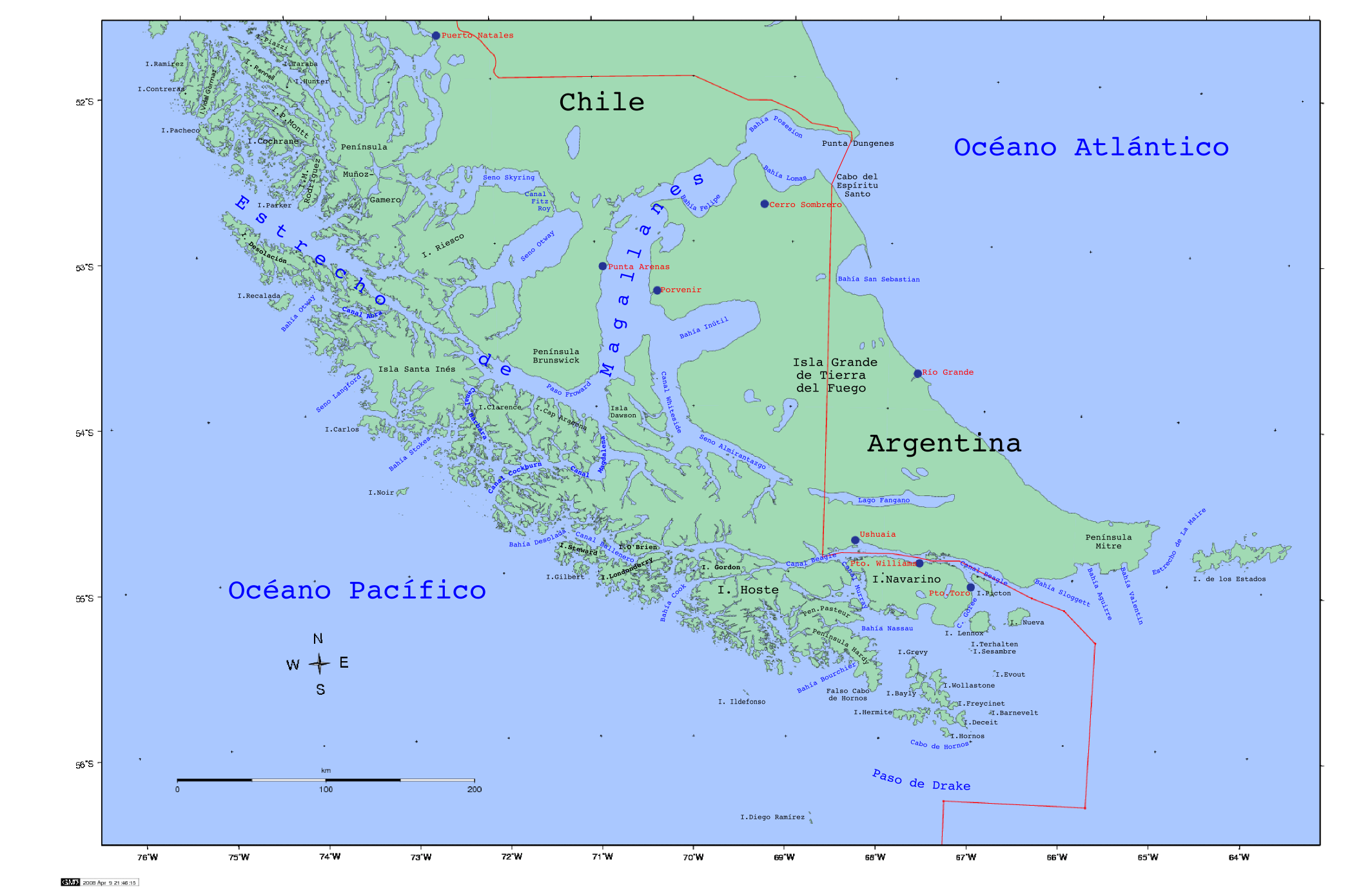