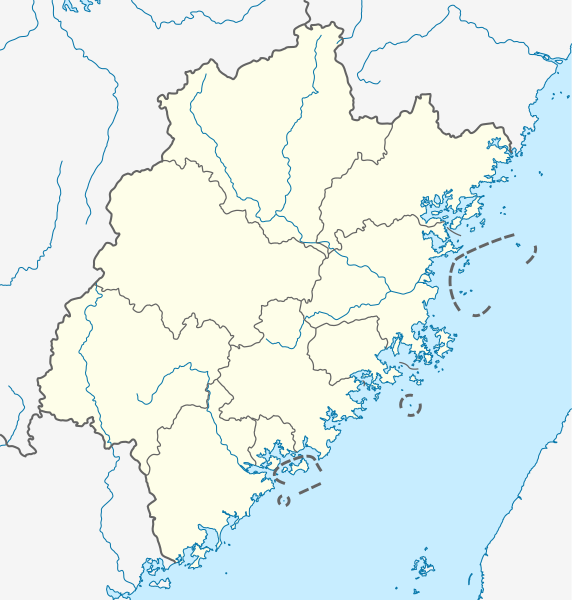
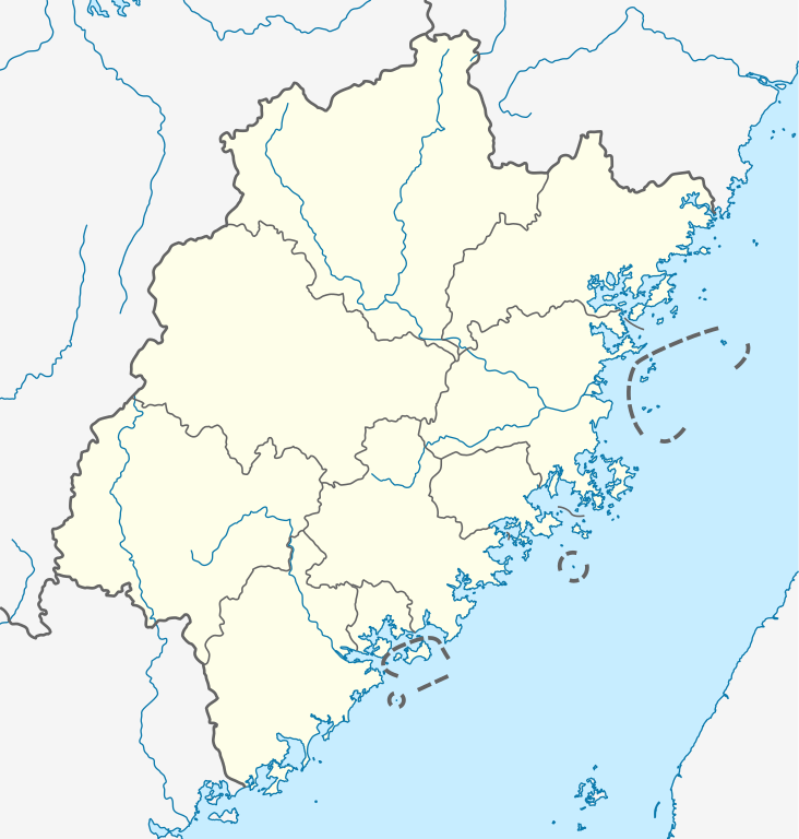
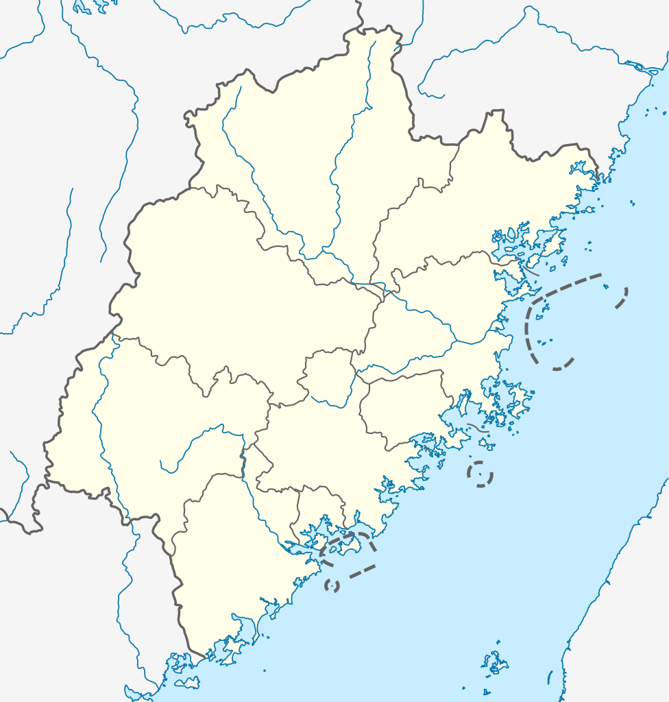
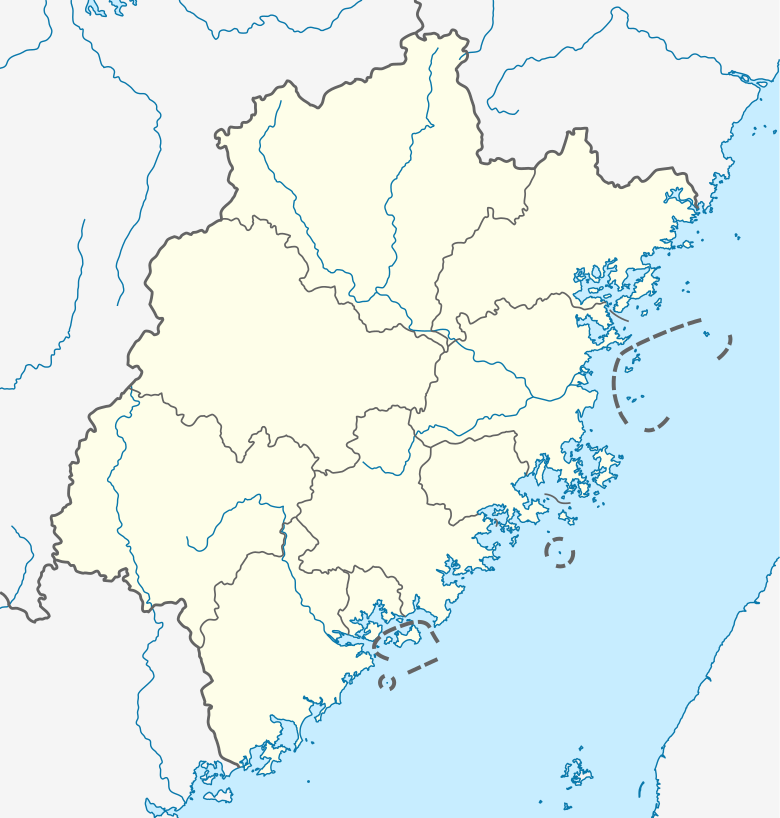
Deutsch: Positionskarte von Fujian, Volksrepublik China
Quadratische Plattkarte, N-S-Streckung 111 %. Geographische Begrenzung der Karte:
N: 28.5° N
S: 23.3° N
W: 115.5° O
O: 121.0° O
English: Location map of Fujian, People's Republic of China (Note: the insular counties of Kinmen (Quemoy) and Lienchiang (Matsu Islands), Taiwan (ROC), are shown with dashed lines.)
Equirectangular projection, N/S stretching 111 %. Geographic limits of the map:
N: 28.5° N
S: 23.3° N
W: 115.5° E
E: 121.0° E
วันที่
แหล่งที่มา
งานของตัว, using
United States National Imagery and Mapping Agency data
World Data Base II data
Fujian province administrative regions GIS data: 1:1.000.000, County level, 1990
ผู้สร้างสรรค์
NordNordWest
การอนุญาต (การใช้ไฟล์นี้ใหม่)
I have published this file as author NordNordWest under the "CC-BY-SA-3.0-DE" in Wikipedia. This means that free, commercial usage outside of Wikipedia is permitted under the following licence terms:
Online media:
The author "NordNordWest/Wikipedia" is named
A weblink to the original file is provided: //commons.wikimedia.org/wiki/File:China_Fujian2_location_map.svg
Please send me a specimen copy or the URL of the website where the file is used.
Please write an email to nnwest[at]web.de if you
need my postal address for sending a specimen copy
have further questions about the terms of the licence
PS: In case of refusal of the above terms the author reserves the right to take legal action.
This file has been released under a license which is incompatible with Facebook's licensing terms. It is not permitted to upload this file to Facebook.
azərbaycanca ∙ Deutsch (Sie-Form) ∙ čeština ∙ Deutsch ∙ sicilianu ∙ italiano ∙ русский ∙ română ∙ português ∙ English ∙ magyar ∙ Nederlands ∙ slovenščina ∙ polski ∙ latviešu ∙ македонски ∙ español ∙ فارسی ∙ français ∙ suomi ∙ עברית ∙ Plattdüütsch ∙ ქართული ∙ հայերեն ∙ বাংলা ∙ ไทย ∙ 日本語 ∙ 中文 ∙ 中文(简体) ∙ 中文(繁體) ∙ العربية ∙ +/−
ไฟล, china, fujian2, location, ไฟล, ประว, ไฟล, หน, าท, ภาพน, การใช, ไฟล, วนกลาง, อม, ลเก, ยวก, บภาพขนาดของต, วอย, าง, ของไฟล, กเซล, ความละเอ, ยดอ, กเซล, กเซล, กเซล, กเซล, กเซล, กเซล, ภาพท, ความละเอ, ยดส, งกว, 8206, ไฟล, กเซล, ขนาดไฟล, โลไบต, ปภาพหร, อไฟล, เส, . ifl prawtiifl hnathimiphaphni karichiflswnklang khxmulekiywkbphaphkhnadkhxngtwxyang PNG nikhxngifl SVG ni 572 600 phikesl khwamlaexiydxun 229 240 phikesl 458 480 phikesl 732 768 phikesl 976 1 024 phikesl 1 953 2 048 phikesl 780 818 phikesl duphaphthimikhwamlaexiydsungkwa 8206 ifl SVG 780 818 phikesl khnadifl 277 kiolibt rupphaphhruxiflesiyngni tnchbbxyuthi khxmmxns raylaexiyddanlang epnkhxkhwamthiaesdngphlcak ifltnchbbinkhxmmxns khxmmxnsepnewbistinokhrngkarsahrbekbrwbrwmsuxesri thi khunsamarthchwyid khwamyx khaxthibayChina Fujian2 location map svg Deutsch Positionskarte von Fujian Volksrepublik China Quadratische Plattkarte N S Streckung 111 Geographische Begrenzung der Karte N 28 5 N S 23 3 N W 115 5 O O 121 0 OEnglish Location map of Fujian People s Republic of China Note the insular counties of Kinmen Quemoy and Lienchiang Matsu Islands Taiwan ROC are shown with dashed lines Equirectangular projection N S stretching 111 Geographic limits of the map N 28 5 N S 23 3 N W 115 5 E E 121 0 Ewnthi 20 mithunayn ph s 2554aehlngthima ngankhxngtw using United States National Imagery and Mapping Agency data World Data Base II data Fujian province administrative regions GIS data 1 1 000 000 County level 1990phusrangsrrkh NordNordWestkarxnuyat karichiflniihm I have published this file as author NordNordWest under the CC BY SA 3 0 DE in Wikipedia This means that free commercial usage outside of Wikipedia is permitted under the following licence terms Online media The author NordNordWest Wikipedia is named A weblink to the original file is provided commons wikimedia org wiki File China Fujian2 location map svg A copy of or the Uniform Resource Identifier https creativecommons org licenses by sa 3 0 de legalcode for this licence with every copy Print media The author NordNordWest Wikipedia is named A copy of or the Uniform Resource Identifier https creativecommons org licenses by sa 3 0 de legalcode for this licence with every copyPlease send me a specimen copy or the URL of the website where the file is used Please write an email to nnwest at web de if you need my postal address for sending a specimen copy have further questions about the terms of the licencePS In case of refusal of the above terms the author reserves the right to take legal action This file has been released under a license which is incompatible with Facebook s licensing terms It is not permitted to upload this file to Facebook iflnixyuphayitsyyaxnuyat khriexthifkhxmmxns aebbaesdngthima xnuyataebbediywkn 3 0 khxngpraethseyxrmnikhunsamarth thicaaebngpn thicathasaena aeckcay aelasngngandngklawtxip thicaeriyberiyngihm thicaddaeplngngandngklaw phayitenguxnikhtxipni aesdngthima khuntxngihekiyrtiecakhxngnganxyangehmaasm odyephimlingkipyngsyyaxnuyat aelarabuhakmikarepliynaeplng khunxacthaechnniidinrupaebbidkidtamkhwr aettxngimichinlksnathiaenawaphuihxnuyatsnbsnunkhunhruxkarichngankhxngkhun xnuyataebbediywkn hakkhunddaeplng epliynrup hruxtxetimnganni khuntxngichsyyaxnuyataebbediywknhruxaebbthiehmuxnkbsyyaxnuyatthiichkbnganniethannhttps creativecommons org licenses by sa 3 0 de deed en CC BY SA 3 0 de Creative Commons Attribution Share Alike 3 0 de true true iflnixyuphayitsyyaxnuyat khriexthifkhxmmxns aebbaesdngthima xnuyataebbediywkn 3 0 tnchbbkhunsamarth thicaaebngpn thicathasaena aeckcay aelasngngandngklawtxip thicaeriyberiyngihm thicaddaeplngngandngklaw phayitenguxnikhtxipni aesdngthima khuntxngihekiyrtiecakhxngnganxyangehmaasm odyephimlingkipyngsyyaxnuyat aelarabuhakmikarepliynaeplng khunxacthaechnniidinrupaebbidkidtamkhwr aettxngimichinlksnathiaenawaphuihxnuyatsnbsnunkhunhruxkarichngankhxngkhun xnuyataebbediywkn hakkhunddaeplng epliynrup hruxtxetimnganni khuntxngichsyyaxnuyataebbediywknhruxaebbthiehmuxnkbsyyaxnuyatthiichkbnganniethannhttps creativecommons org licenses by sa 3 0 CC BY SA 3 0 Creative Commons Attribution Share Alike 3 0 true true aephnthinithuksranghruxphthnakhuncak Kartenwerkstatt hxngptibtikaraephnthi khxngwikiphiediyphasaeyxrmn sungkhunsamarthesnxaephnthiephuxphthnaidechnediywkn azerbaycanca Deutsch Sie Form cestina Deutsch sicilianu italiano russkij romană portugues English magyar Nederlands slovenscina polski latviesu makedonski espanol فارسی francais suomi עברית Plattduutsch ქართული հայերեն ব ল ithy 日本語 中文 中文 简体 中文 繁體 العربية khabrryayodyyxithyephimkhabrryaythrrthdediywephuxkhyaykhwamwaiflnimixairixethmthiaesdngxyuiniflniprakxbdwyphusrangbangkhathiimmiixethmwikisnethschuxphusrangsrrkh NordNordWestchuxphuichwikimiediy NordNordWestyuxaraexl http commons wikimedia org wiki User NordNordWeststhanalikhsiththimilikhsiththisyyaxnuyatCreative Commons Attribution ShareAlike 3 0 Unported xngkvsCreative Commons Attribution ShareAlike 3 0 Germany xngkvswnthisrang wnkxtng20 mithunayn 2011thimakhxngiflkarsrangdngedimodyphuxpohldMIME type xngkvsimage svg xml prawtiifl khlikwnthi ewlaephuxduiflthipraktinkhnann wnthi ewlarupyxkhnadphuichkhwamehn pccubn00 21 15 tulakhm 2563780 818 277 kiolibt NordNordWestupd 19 18 20 mithunayn 2554780 818 282 kiolibt NordNordWest int filedesc Information Description de Positionskarte von Fujian Volksrepublik China Quadratische Plattkarte N S Streckung 111 Geographische Begrenzung der Karte N 28 5 N S 23 3 N hnathimiphaphni hnatxipni oyngmathiphaphni xaephxphinghnan mnthlfueciyn mxdul Location map data China Fujian mxdul Location map data China Fujian doc karichiflswnklang wikixuntxipniichiflni karichbn ar wikipedia org قالب Location map China Fujian karichbn bg wikipedia org Fudzhou Syamn Dzhandzhou Shablon PK Kitaj Fudzien Bandzaj Mindzyan basejna na Iztochnokitajsko more karichbn bn wikipedia org জ য ওশ নচ জ ল মড উল অবস থ ন ম নচ ত র উপ ত ত গণচ ন ফ চ য ন মড উল অবস থ ন ম নচ ত র উপ ত ত গণচ ন ফ চ য ন নথ karichbn cdo wikipedia org Dai gĕ ng Ming au Bing tang Bing nang Lo nguong Hok chiăng Ha puō Kŭ cheng Ma muōi Gu lau Ceng ăng Chŏng săng Diong lŏ h ing tai Lieng gŏng Ming chiăng Hok ăng karichbn ceb wikipedia org Plantilya Location map China Fujian karichbn cs wikipedia org Sablona LocMap Cina Fu tien Pirati wo kchou v ere Tia ting Jue kang karichbn en wikipedia org Taiwan Strait Guanghua Temple Putian Lianjiang County Gulangyu Xiang an District Wanfu Temple Fuqing Xiamen Island Fengcheng Lianjiang County Jianyang District Jian ou Wuyi Mountains Gutian County Yong an Shouning County Xiamen Gaoqi International Airport Jinjiang Fujian Anxi County Shenhu dukarichthwolkephimetimkhxngiflnikhxmulekiywkbphaph phaphnimikhxmulephimetim sungswnihymacakklxngdicitxlhruxsaeknenxrthisamarthekbkhxmuldngklawiwrwmkbphaphid thaphaphnithukprbprungaekikhhruxepliynaeplngcakedim khxmulbangxyangcayngkhngimepliynaeplngehmuxnphaphthithukprbprungaekikhnnkhwamkwang779 779pxkhwamsung818 084px ekhathungcak https th wikipedia org wiki ifl China Fujian2 location map svg, wikipedia, วิกิ หนังสือ, หนังสือ, ห้องสมุด,