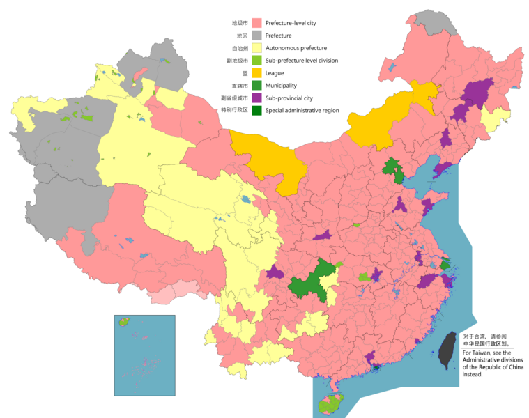
English: Note: this map contains various disputed country claims:
Largely controls and claims disputed various areas: such as part of Arunachal Pradesh and the Trans-Karakoram Tract but claimed or controlled by default.
Includes Taiwan: This map that includes the part of Kinmen and the Matsu Islands near the province of Fujian, but it will used to a darker color by default.
Sansha prefecture-level city is disputed: The map is shown that disputed Paracel Islands, due to claims from Vietnam and Taiwan, but not shown by default.
The boundaries on this map show the de facto situation. This is just one of several different views on the subject (see COM:NPOV).
This image is expected to always be the most recent one. Feel free to update it when needed.
This file may be updated to reflect new information. If you wish to use a specific version of the file without new updates being mirrored, please upload the required version as a separate file.
ความย่อ
คำอธิบายChina prefectural-level divisions and administrative divisions (PRoC claim).png
English: Map of China, shows provinces, prefecture-level divisions, etc.
日本語: 中国の地図、州、県レベルの区分などを示しています。
Русский: Карта Китая, показывает провинции, подразделения на уровне префектур и т. Д.
Карта Китая показывает, что он разделен на провинции, муниципалитеты, особые административные районы и подразделения на уровне префектур, и префектура.
中國地圖顯示,分為省、直轄市、特別行政區、地級區劃、 和縣。
El mapa de China muestra que se divide en provincias, municipios, regiones administrativas especiales y divisiones a nivel de prefectura, y prefectura.
Çin haritası, illere, belediyelere, özel idari bölgelere ve il düzeyinde bölümlere ve vilayete ayrıldığını gösterir.
Peta Cina menunjukkan bahwa dibagi menjadi provinsi, kotamadya, wilayah administrasi khusus, dan divisi tingkat prefektur, dan prefektur.
Kaart van China toont dat verdeeld in provincies, gemeenten, speciale administratieve regio's, en prefectuur-niveau divisies, en prefectuur.
Die Karte von China zeigt, dass sie in Provinzen, Gemeinden, Sonderverwaltungsregionen und Präfekturbezirke und Präfekturen unterteilt ist.
تُظهر خريطة الصين تقسيمها إلى مقاطعات وبلديات ومناطق إدارية خاصة وأقسام على مستوى المحافظة ومحافظة.
中國地圖顯示,分為省、市、特別行政區、地級區和地級區。
Tabula Sinarum ostendit divisam in provincias, municipia, regiones administrativas et praefecturas-gradas ac praefecturas.
Mapa Chin pokazuje podział na prowincje, gminy, specjalne regiony administracyjne i podziały na poziomie prefektury oraz prefekturę.
Ipinapakita ng mapa ng China na nahahati sa mga lalawigan, munisipalidad, espesyal na administratibong rehiyon, at mga dibisyon sa antas ng prefecture, at prefecture.
El mapa de la Xina mostra que es divideix en províncies, municipis, regions administratives especials i divisions a nivell de prefectura i prefectura.
На карті Китаю показано, що він розділений на провінції, муніципалітети, спеціальні адміністративні райони, а також відділи на рівні префектур і префектури.
La carte de la Chine montre qu'elle est divisée en provinces, municipalités, régions administratives spéciales et divisions au niveau de la préfecture et préfecture.
चीन के मानचित्र से पता चलता है कि प्रांतों, नगर पालिकाओं, विशेष प्रशासनिक क्षेत्रों और प्रीफेक्चर-स्तरीय डिवीजनों और प्रीफेक्चर में विभाजित है।
চীনের মানচিত্র দেখায় যে প্রদেশ, পৌরসভা, বিশেষ প্রশাসনিক অঞ্চল এবং প্রিফেকচার-স্তরের বিভাগ এবং প্রিফেকচারে বিভক্ত।
Ο χάρτης της Κίνας δείχνει ότι χωρίζεται σε επαρχίες, δήμους, ειδικές διοικητικές περιφέρειες και τμήματα σε επίπεδο νομού και νομό.
Kart over Kina viser at delt inn i provinser, kommuner, spesielle administrative regioner, og prefektur-nivå divisjoner, og prefektur.
نقشه چین نشان میدهد که به استانها، شهرداریها، مناطق اداری ویژه و بخشهای سطح استان، و استان تقسیم شده است.
Kort over Kina viser, at opdelt i provinser, kommuner, særlige administrative regioner, og præfektur-niveau divisioner, og præfektur.
Hiina kaart näitab, et see jaguneb provintsideks, omavalitsusüksusteks, erihalduspiirkondadeks ja prefektuuri tasandi rajooniks ning prefektuuriks.
Қытай картасы провинцияларға, муниципалитеттерге, арнайы әкімшілік аймақтарға және префектура деңгейіндегі бөлімдерге және префектураға бөлінген.
O mapa da China mostra isso dividido em províncias, municípios, regiões administrativas especiais e divisões em nível de prefeitura e prefeitura.
Mapa Číny ukazuje, že se dělí na provincie, obce, zvláštní administrativní oblasti a divize na úrovni prefektury a prefektury.
Kína térképe azt mutatja, hogy tartományokra, önkormányzatokra, speciális közigazgatási régiókra, prefektúra szintű felosztásokra és prefektúrákra osztva.
Harta Chinei arată că împărțit în provincii, municipalități, regiuni administrative speciale și divizii la nivel de prefectură și prefectură.
Мапа Кине показује да је подељена на провинције, општине, посебне административне регионе и поделе на нивоу префектура и префектуре.
چين جو نقشو ڏيکاري ٿو ته صوبن ۾ ورهايل، ميونسپلٽي، خاص انتظامي علائقن، ۽ صوبن جي سطح جي ڊويزن، ۽ پريفيڪچر.
Mapa Číny ukazuje, že je rozdelená na provincie, obce, špeciálne administratívne oblasti a divízie na úrovni prefektúry a prefektúry.
Харитаи Чин нишон медиҳад, ки ба музофотҳо, муниципалитетҳо, минтақаҳои махсуси маъмурӣ ва воҳидҳои сатҳи префектура ва префектураҳо тақсим карда шудаанд.
Léiríonn Léarscáil na Síne go roinnte i gcúigí, bardais, réigiúin riaracháin speisialta, agus rannáin leibhéal prefecture, agus prefecture.
Txinako mapak probintzian, udalerrietan, eskualde administratibo berezietan eta prefektura mailan eta prefekturan banatuta erakusten du.
מפה של סין מראה את זה מחולק למחוזות, עיריות, אזורים מנהליים מיוחדים, חטיבות ברמת הפריפקטורה, ומחוז.
Kort af Kína sýnir að skipt í héruð, sveitarfélög, sérstök stjórnsýslu svæði, og héraðs-stigi deildir, og hérað.
Kaart fan Sina lit sjen dat ferdield yn provinsjes, gemeenten, spesjale bestjoerlike regio's, en prefektuer-nivo divyzjes, en prefektuer.
Peta China menunjukkan bahawa dibahagikan kepada wilayah, majlis perbandaran, wilayah pentadbiran khas, dan bahagian peringkat wilayah, dan wilayah.
ไฟล, china, prefectural, level, divisions, administrative, divisions, proc, claim, ไฟล, ประว, ไฟล, หน, าท, ภาพน, การใช, ไฟล, วนกลาง, อม, ลเก, ยวก, บภาพขนาดของต, วอย, างน, กเซล, ความละเอ, ยดอ, กเซล, กเซล, กเซล, กเซล, กเซล, กเซล, ภาพท, ความละเอ, ยดส, งกว, 8206, . ifl prawtiifl hnathimiphaphni karichiflswnklang khxmulekiywkbphaphkhnadkhxngtwxyangni 759 600 phikesl khwamlaexiydxun 304 240 phikesl 607 480 phikesl 972 768 phikesl 1 280 1 012 phikesl 2 560 2 023 phikesl 6 246 4 937 phikesl duphaphthimikhwamlaexiydsungkwa 8206 6 246 4 937 phikesl khnadifl 987 kiolibt chnidimm image png rupphaphhruxiflesiyngni tnchbbxyuthi khxmmxns raylaexiyddanlang epnkhxkhwamthiaesdngphlcak ifltnchbbinkhxmmxns khxmmxnsepnewbistinokhrngkarsahrbekbrwbrwmsuxesri thi khunsamarthchwyid English Note this map contains various disputed country claims Largely controls and claims disputed various areas such as part of Arunachal Pradesh and the Trans Karakoram Tract but claimed or controlled by default Includes Taiwan This map that includes the part of Kinmen and the Matsu Islands near the province of Fujian but it will used to a darker color by default Sansha prefecture level city is disputed The map is shown that disputed Paracel Islands due to claims from Vietnam and Taiwan but not shown by default 日本語 ノート この地図には さまざまな係争中の国の主張が含まれています さまざまな分野で主に統制と主張が争われている アルナーチャルプラデーシュ州やトランスカラコラムトラクトの一部などですが デフォルトで主張または管理されています 台湾を含む この地図には 福建省の近くの金門と馬祖島の一部が含まれていますが デフォルトでは暗い色に使用されます 三社県地級市が争われている ベトナムと台湾からの主張により西沙諸島が争われたマップが示されていますが デフォルトでは表示されていません 中文 简体 笔记 该地图包含各种有争议的国家主张 很大程度上控制和索赔有争议的各个领域 例如阿鲁纳恰尔邦和跨喀喇昆仑地区的一部分 但在默认情况下声称或控制 包括台湾 此地图包括福建省附近的金门和马祖群岛部分 但默认情况下会使用较深的颜色 三沙地级市有争议 由于越南和台湾的主权要求 该地图显示有争议的西沙群岛 但默认情况下未显示 中文 繁體 筆記 這張地圖包含各種有爭議的國家主張 很大程度上控制和索賠在各個領域有爭議 例如阿魯納恰爾邦和外喀喇崑崙地區的一部分 但默認聲明或控制 包括台灣 這張地圖包含了福建省附近的金門和馬祖群島的部分 但默認會使用較深的顏色 三沙地級市有爭議 由於越南和台灣的主權要求 該地圖顯示有爭議的西沙群島 但默認情況下未顯示 The boundaries on this map show the de facto situation This is just one of several different views on the subject see COM NPOV This image is expected to always be the most recent one Feel free to update it when needed This file may be updated to reflect new information If you wish to use a specific version of the file without new updates being mirrored please upload the required version as a separate file khwamyx khaxthibayChina prefectural level divisions and administrative divisions PRoC claim png English Map of China shows provinces prefecture level divisions etc 日本語 中国の地図 州 県レベルの区分などを示しています Russkij Karta Kitaya pokazyvaet provincii podrazdeleniya na urovne prefektur i t D Mongol Hyatad ulsyn gazryn zurag muzhuud muzhijn tүvshnij heltes geh metijg haruulsan 中文 简体 中华人民共和国地图 显示省 地级区划等 包含未实际控制之疆域 中文 繁體 中華人民共和國地圖 顯示省 地級區劃等 包含未實際控制之疆域 khaxthibayaephnthi English nbsp Prefecture level city nbsp Prefecture nbsp Autonomous prefecture nbsp Sub prefecture level division nbsp League nbsp Municipality nbsp Sub provincial city nbsp Special administrative region 图例 中文 简体 nbsp 地级市 nbsp 地区 nbsp 自治州 nbsp 副地级市 nbsp 盟 nbsp 直辖市 nbsp 副省级市 nbsp 特别行政区 圖例 中文 繁體 nbsp 地級市 nbsp 地區 nbsp 自治州 nbsp 副地級市 nbsp 盟 nbsp 直轄市 nbsp 副省級市 nbsp 特別行政區 wnthi English File uploaded November 6 2021 English Original uploaded September 12 2011 Latest update 07 09 17 November 2023 中文 简体 原始上传时间2011年9月12日 中文 繁體 文件上传时间2021年11月6日 中文 繁體 原始上傳時間2011年9月12日 aehlngthima English Source appearances 中文 简体 来源于 中文 繁體 來源於 aekikh Blank map Sub prefecture boundaries phusrang AichiWikiFixer Not logging in and Maanshen Original ASDFGH karxnuyat karichiflniihm English Map of China administrative divisions 中文 简体 中国地图 行政区划 中文 繁體 中國地圖 行政區劃khapheca inthanaphuthuxlikhsiththikhxngphaphhruxsuxni xnuyatihichphaphhruxsuxniphayitenguxnikhtxipni Public domain Public domain false false phaphni khadkhunsmbtisahrbkarmilikhsiththi dngnnphaphnicungepn satharnsmbti enuxngcakepnsmbtiswnrwmaelaimmikarrabukhwamepnecakhxng prakasnimiphlthwolk nbsp Geotemporal data Date depicted as of February 4 2021 Spatial reference system Custom phikdxangxingthangphumisastr duaephnthithixangxingthangphumisastrcak Wikimaps Warper ewxrchnxun English Other languages 中文 简体 其他语言 中文 繁體 其他語言 aekikh English and Chinese Simplified 中文 简体 Slovenian slovenscina Derivative works on these files File China blank map by prefectures png File COVID 19 cases in mainland China by Prefectures png File Yangtze River Delta gif File Other Kinds of Statistics in China png File COVID 19 cases in PRC claimed territory by Prefectures png File Pourcentage de han png karxnuyatichsiththi khapheca inthanaphuthuxlikhsiththikhxngphaphhruxsuxni xnuyatihichphaphhruxsuxniphayitenguxnikhtxipniiflnixyuphayitsyyaxnuyat khriexthifkhxmmxns aebbaesdngthima xnuyataebbediywkn 4 0 nanachatikhunsamarth thicaaebngpn thicathasaena aeckcay aelasngngandngklawtxip thicaeriyberiyngihm thicaddaeplngngandngklaw phayitenguxnikhtxipni aesdngthima khuntxngihekiyrtiecakhxngnganxyangehmaasm odyephimlingkipyngsyyaxnuyat aelarabuhakmikarepliynaeplng khunxacthaechnniidinrupaebbidkidtamkhwr aettxngimichinlksnathiaenawaphuihxnuyatsnbsnunkhunhruxkarichngankhxngkhun xnuyataebbediywkn hakkhunddaeplng epliynrup hruxtxetimnganni khuntxngichsyyaxnuyataebbediywknhruxaebbthiehmuxnkbsyyaxnuyatthiichkbnganniethannhttps creativecommons org licenses by sa 4 0 CC BY SA 4 0 Creative Commons Attribution Share Alike 4 0 true true phaphaephnthirabutaaehnngni khwrcathuksrangihmepnkrafiksewketxr sungmikhxdixikhlayprakar duephimetimthikhxmmxns suxtxngkarekbkwadsahrbsarsnethsephimetim hakphaphnimiinrupaebbkrafiksewketxrxyuaelw krunaxpohldaelaaethnthiaemaebbnidwy vector version available i chuxphaphihm i aenanaepnxyangyingihtngchuxiflewketxrihmnninrupaebb China prefectural level divisions and administrative divisions PRoC claim svg aelwisaemaebb Vector version available hrux Vva sungimtxngichpharamietxr chuxphaphihm phaphaephnthini khwrcathuksrangihmepnkrafiksewketxr sungmikhxdixikhlayprakar duephimetimthikhxmmxns suxtxngkarekbkwadsahrbsarsnethsephimetim hakphaphnimiinrupaebbkrafiksewketxrxyuaelw krunaxpohldaelaaethnthiaemaebbnidwy vector version available i chuxphaphihm i aenanaepnxyangyingihtngchuxiflewketxrihmnninrupaebb China prefectural level divisions and administrative divisions PRoC claim svg aelwisaemaebb Vector version available hrux Vva sungimtxngichpharamietxr chuxphaphihm AnnotationsInfoFieldThis image is annotated View the annotations at Commons1703 3275 979 337 6246 4937 India s controlled from the part of the internal Arunachal Pradesh but it claims with two prefecture level cities in the country 370 1868 362 362 6246 4937 Aksai Chin is disputed but controls in this prefecture and neither claimed by India 5481 3744 189 148 6246 4937 China s claims the disputed Senkaku Islands and its part of a claimed territory and controlled by Japan 4929 4040 74 74 6246 4937 Kinmen annexation of Fujian province and it is controlled by Taiwan 189 1711 206 247 6246 4937 The Trans Karakoram Tract is neither claimed by India khabrryayodyyxithyephimkhabrryaythrrthdediywephuxkhyaykhwamwaiflnimixairxngkvsMap of China shows that divided into provinces municipalities special administrative regions and prefecture level divisions and prefecture yipun中国の地図は 州 市町村 特別行政区 および県レベルの部門に分割されていることを示しています と都道府県 rsesiyKarta Kitaya pokazyvaet chto on razdelen na provincii municipalitety osobye administrativnye rajony i podrazdeleniya na urovne prefektur i prefektura cin中國地圖顯示 分為省 直轄市 特別行政區 地級區劃 和縣 sepnEl mapa de China muestra que se divide en provincias municipios regiones administrativas especiales y divisiones a nivel de prefectura y prefectura mxngokeliyHyatad ulsyn gazryn zurag n muzh hotyn zahirgaa zasag zahirgaany tusgaj bүs muzhijn tүvshnij heltest huvaagdsanyg haruulzh bajna bolon muzh ekahli중국 지도는 성 시정촌 특별행정구 현급 구분 현으로 구분되어 있음을 보여줍니다 turkiCin haritasi illere belediyelere ozel idari bolgelere ve il duzeyinde bolumlere ve vilayete ayrildigini gosterir xinodniesiyPeta Cina menunjukkan bahwa dibagi menjadi provinsi kotamadya wilayah administrasi khusus dan divisi tingkat prefektur dan prefektur dtchKaart van China toont dat verdeeld in provincies gemeenten speciale administratieve regio s en prefectuur niveau divisies en prefectuur eyxrmnDie Karte von China zeigt dass sie in Provinzen Gemeinden Sonderverwaltungsregionen und Prafekturbezirke und Prafekturen unterteilt ist xahrbomrxkokت ظهر خريطة الصين تقسيمها إلى مقاطعات وبلديات ومناطق إدارية خاصة وأقسام على مستوى المحافظة ومحافظة cintwetm中國地圖顯示 分為省 市 特別行政區 地級區和地級區 latinTabula Sinarum ostendit divisam in provincias municipia regiones administrativas et praefecturas gradas ac praefecturas opaelndMapa Chin pokazuje podzial na prowincje gminy specjalne regiony administracyjne i podzialy na poziomie prefektury oraz prefekture takalxkIpinapakita ng mapa ng China na nahahati sa mga lalawigan munisipalidad espesyal na administratibong rehiyon at mga dibisyon sa antas ng prefecture at prefecture khatalnEl mapa de la Xina mostra que es divideix en provincies municipis regions administratives especials i divisions a nivell de prefectura i prefectura yuekhrnNa karti Kitayu pokazano sho vin rozdilenij na provinciyi municipaliteti specialni administrativni rajoni a takozh viddili na rivni prefektur i prefekturi frngessLa carte de la Chine montre qu elle est divisee en provinces municipalites regions administratives speciales et divisions au niveau de la prefecture et prefecture hindiच न क म नच त र स पत चलत ह क प र त नगर प ल क ओ व श ष प रश सन क क ष त र और प र फ क चर स तर य ड व जन और प र फ क चर म व भ ज त ह bngklaচ ন র ম নচ ত র দ খ য য প রদ শ প রসভ ব শ ষ প রশ সন ক অঞ চল এব প র ফ কচ র স তর র ব ভ গ এব প র ফ কচ র ব ভক ত krikO xarths ths Kinas deixnei oti xwrizetai se eparxies dhmoys eidikes dioikhtikes perifereies kai tmhmata se epipedo nomoy kai nomo nxrewyKart over Kina viser at delt inn i provinser kommuner spesielle administrative regioner og prefektur niva divisjoner og prefektur epxresiyنقشه چین نشان می دهد که به استان ها شهرداری ها مناطق اداری ویژه و بخش های سطح استان و استان تقسیم شده است ednmarkKort over Kina viser at opdelt i provinser kommuner saerlige administrative regioner og praefektur niveau divisioner og praefektur exsoteniyHiina kaart naitab et see jaguneb provintsideks omavalitsusuksusteks erihalduspiirkondadeks ja prefektuuri tasandi rajooniks ning prefektuuriks khaskhҚytaj kartasy provinciyalarga municipalitetterge arnajy әkimshilik ajmaktarga zhәne prefektura dengejindegi bolimderge zhәne prefekturaga bolingen oprtueksO mapa da China mostra isso dividido em provincias municipios regioes administrativas especiais e divisoes em nivel de prefeitura e prefeitura echkMapa Ciny ukazuje ze se deli na provincie obce zvlastni administrativni oblasti a divize na urovni prefektury a prefektury hngkariKina terkepe azt mutatja hogy tartomanyokra onkormanyzatokra specialis kozigazgatasi regiokra prefektura szintu felosztasokra es prefekturakra osztva ormaeniyHarta Chinei arată că impărțit in provincii municipalități regiuni administrative speciale și divizii la nivel de prefectură și prefectură esxrebiyMapa Kine pokazuјe da јe podeљena na provinciјe opshtine posebne administrativne regione i podele na nivou prefektura i prefekture sinthiچين جو نقشو ڏيکاري ٿو ته صوبن ورهايل ميونسپلٽي خاص انتظامي علائقن صوبن جي سطح جي ڊويزن پريفيڪچر solwkMapa Ciny ukazuje ze je rozdelena na provincie obce specialne administrativne oblasti a divizie na urovni prefektury a prefektury thacikHaritai Chin nishon mediҳad ki ba muzofotҳo municipalitetҳo mintakaҳoi mahsusi mamurӣ va voҳidҳoi satҳi prefektura va prefekturaҳo taksim karda shudaand ixrichLeirionn Learscail na Sine go roinnte i gcuigi bardais reigiuin riarachain speisialta agus rannain leibheal prefecture agus prefecture baskTxinako mapak probintzian udalerrietan eskualde administratibo berezietan eta prefektura mailan eta prefekturan banatuta erakusten du hibruמפה של סין מראה את זה מחולק למחוזות עיריות אזורים מנהליים מיוחדים חטיבות ברמת הפריפקטורה ומחוז ixsaelndKort af Kina synir ad skipt i herud sveitarfelog serstok stjornsyslu svaedi og herads stigi deildir og herad friesiyntawntkKaart fan Sina lit sjen dat ferdield yn provinsjes gemeenten spesjale bestjoerlike regio s en prefektuer nivo divyzjes en prefektuer maelyPeta China menunjukkan bahawa dibahagikan kepada wilayah majlis perbandaran wilayah pentadbiran khas dan bahagian peringkat wilayah dan wilayah ixethmthiaesdngxyuiniflniprakxbdwyphusrangbangkhathiimmiixethmwikisnethsyuxaraexl https commons wikimedia org wiki user AichiWikiFixerchuxphusrangsrrkh AichiWikiFixerchuxphuichwikimiediy AichiWikiFixersthanalikhsiththimilikhsiththisatharnsmbtisyyaxnuyatCreative Commons Attribution ShareAlike 3 0 Unported nbsp xngkvsCreative Commons Attribution ShareAlike 4 0 International nbsp xngkvswnthisrang wnkxtng12 knyayn 2011thimakhxngiflkarsrangdngedimodyphuxpohldMIME type nbsp xngkvsimage pngchecksum nbsp xngkvs2948b37b996ded6d63d5ede201db0a3f35266d62withikarkahnd SHA 1 nbsp xngkvsdata size nbsp xngkvs1 011 100 ibtkhwamsung4 937 phikeslkhwamkwang6 246 phikesl prawtiifl khlikwnthi ewlaephuxduiflthipraktinkhnann lasud ekasud du ihmkwa 10 ekakwa 10 10 20 50 100 250 500 wnthi ewlarupyxkhnadphuichkhwamehn pccubn09 26 11 singhakhm 25666 246 4 937 987 kiolibt Vikarna州 地区 amp 副地级划分 副地级市 15 59 1 singhakhm 25666 246 4 937 987 kiolibt MaanshenAdd Baiyang county level city 16 50 1 thnwakhm 25656 246 4 937 987 kiolibt MaanshenRe added disputed borders from the third version and removed the nine dash line to prevent future bans to maps 12 28 23 phvscikayn 25656 246 4 937 951 kiolibt Vikarnamunicipality 市政府 直辖市 12 10 23 phvscikayn 25656 246 4 937 986 kiolibt VikarnaLeague 联盟 盟 06 06 3 singhakhm 25656 246 4 937 992 kiolibt MaanshenUpdate disputed claimed borders white with stroke is not claimed and filled in color is claimed 07 08 20 emsayn 25656 246 4 937 975 kiolibt MaanshenFix borders between Ili 039 s Kuytun Huyanghe and Karamay 10 51 1 minakhm 25656 246 4 937 975 kiolibt MaanshenUpdate Shanghai land reclamation 15 26 28 mkrakhm 25656 246 4 937 975 kiolibt MaanshenFix Changchun Siping border 07 08 28 mkrakhm 25656 246 4 937 975 kiolibt MaanshenAdd parts of Tiemenguan lasud ekasud du ihmkwa 10 ekakwa 10 10 20 50 100 250 500 hnathimiphaphni hnatxipni oyngmathiphaphni cnghwdkhxngpraethscin ekhtkarpkkhrxngkhxngpraethscin karichiflswnklang wikixuntxipniichiflni karichbn ast wikipedia org Prefeutura de la Republica Popular China karichbn bg wikipedia org Gradska prefektura karichbn cs wikipedia org Administrativni deleni Ciny Mestska prefektura Prefektury v Cine Autonomni kraje v Cine Ajmagy v Cine karichbn en wikipedia org Administrative divisions of China User Chochopk Administrative divisions of the People s Republic of China List of prefectures in China Prefecture level divisions of China User SilverStar54 Administrative divisions of China karichbn es wikipedia org Prefectura de la Republica Popular China karichbn fa wikipedia org ولایت های چین karichbn fi wikipedia org Kiinan alueellinen hallinto karichbn fr wikipedia org Prefecture autonome Prefectures de la republique populaire de Chine karichbn id wikipedia org Prefektur Tiongkok karichbn incubator wikimedia org Wp kjh Hydat Chon Respublikazy karichbn ja wikipedia org 民族区域自治 自治州 中国 karichbn pt wikipedia org Prefeituras da Republica Popular da China karichbn ru wikipedia org Administrativnoe delenie Kitajskoj Narodnoj Respubliki Okruga KNR Ajmak KNR Gorod okruzhnogo znacheniya KNR karichbn sh wikipedia org Prefektura Kina karichbn si wikipedia org මක ව ස ක ල ල Prefectural level divisions of the People s Republic of China karichbn sv wikipedia org Ajmag Kinas prefekturer karichbn tr wikipedia org Cin in illeri karichbn ur wikipedia org بیجنگ عوامی جمہوریہ چین کے پریفیکچر سانچہ عوامی جمہوریہ چین کی پریفیکچر سطح تقسیم karichbn vi wikipedia org Khu hanh chinh cấp địa karichbn www wikidata org Q9316670 karichbn wuu wikipedia org 地级行政区 karichbn zh yue wikipedia org 地級 karichbn zh wikipedia org 亳州市 北京市 天津市 抚顺市 合肥市 昆明市 西双版纳傣族自治州 济南市 苏州市 长春市 呼和浩特市 dukarichthwolkephimetimkhxngiflnikhxmulekiywkbphaph phaphnimikhxmulephimetim sungswnihymacakklxngdicitxlhruxsaeknenxrthisamarthekbkhxmuldngklawiwrwmkbphaphid thaphaphnithukprbprungaekikhhruxepliynaeplngcakedim khxmulbangxyangcayngkhngimepliynaeplngehmuxnphaphthithukprbprungaekikhnnkhwamlaexiydaenwnxn37 8 dpckhwamlaexiydaenwtng37 8 dpc ekhathungcak https th wikipedia org wiki ifl China prefectural level divisions and administrative divisions PRoC claim png, wikipedia, วิกิ หนังสือ, หนังสือ, ห้องสมุด,
.png.html)