This map is no longer being updated. The newest version is in GIF format and is located at:
Image:China administrative.gif
This map has been uploaded by Electionworld from en.wikipedia.org to enable the Wikimedia Atlas of the World . Original uploader to en.wikipedia.org was Ran, known as Ran at en.wikipedia.org. Electionworld is not the creator of this map. Licensing information is below.
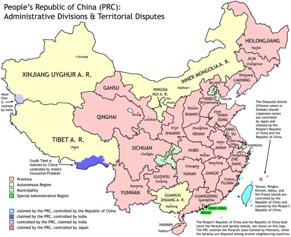
Administrative divisions of China. Made by Ran.
Features:
Latest borders as of 2004. Qinghai-Gansu border readjustments are reflected; Sino-Russian agreement on the Amur-Ussuri delta is also (approximately) reflected.
Disputed areas are given as neutral a treatment as possible.
The map was made based on a large-scale map of China made by woodhome and hunry of the XZQH forums.
Looking for translators!: If you want to translate the map into another language, here's a blank map that you can work with:
Image:China-blank.png
Alternatively, you can message me with the translated texts, and I will incorporate your translations for you and credit you for your work. (You don't have to translate the place names; I'll attempt to get them, as far as possible, from the Wikipedia in that language.) Same goes for any additions or corrections you'd like to make.
Translations have already been done for Spanish, German, Chinese (Simplified/Traditional), Japanese, French, Russian, Macedonian, Vietnamese, and Hebrew.
See also: en:Wikipedia:WikiProject Chinese provinces/Locator maps
{{ew|en|Ran}} Administrative divisions of China. Made by Ranr. Features: * Latest borders as of 2004. {{link|Qinghai}}-{{link|Gansu}} border readjustments are reflected; Sino-Russian agreement on the Amur-Ussuri delta is also (approxim
ไฟล, china, administrative, ไฟล, ประว, ไฟล, หน, าท, ภาพน, การใช, ไฟล, วนกลางขนาดของต, วอย, างน, กเซล, ความละเอ, ยดอ, กเซล, กเซล, กเซล, ภาพท, ความละเอ, ยดส, งกว, 8206, กเซล, ขนาดไฟล, โลไบต, ชน, ดไมม, image, ปภาพหร, อไฟล, เส, ยงน, นฉบ, บอย, คอมมอนส, รายละเอ, ยดด. ifl prawtiifl hnathimiphaphni karichiflswnklangkhnadkhxngtwxyangni 735 599 phikesl khwamlaexiydxun 294 240 phikesl 589 480 phikesl 857 699 phikesl duphaphthimikhwamlaexiydsungkwa 8206 857 699 phikesl khnadifl 95 kiolibt chnidimm image png rupphaphhruxiflesiyngni tnchbbxyuthi khxmmxns raylaexiyddanlang epnkhxkhwamthiaesdngphlcak ifltnchbbinkhxmmxns khxmmxnsepnewbistinokhrngkarsahrbekbrwbrwmsuxesri thi khunsamarthchwyid NOTE by original authorThis map is no longer being updated The newest version is in GIF format and is located at Image China administrative gif This map has been uploaded by Electionworld from en wikipedia org to enable the Wikimedia Atlas of the World Original uploader to en wikipedia org was Ran known as Ran at en wikipedia org Electionworld is not the creator of this map Licensing information is below Administrative divisions of China Made by Ran Features Latest borders as of 2004 Qinghai Gansu border readjustments are reflected Sino Russian agreement on the Amur Ussuri delta is also approximately reflected Disputed areas are given as neutral a treatment as possible The map was made based on a large scale map of China made by woodhome and hunry of the XZQH forums Looking for translators If you want to translate the map into another language here s a blank map that you can work with Image China blank pngAlternatively you can message me with the translated texts and I will incorporate your translations for you and credit you for your work You don t have to translate the place names I ll attempt to get them as far as possible from the Wikipedia in that language Same goes for any additions or corrections you d like to make Translations have already been done for Spanish German Chinese Simplified Traditional Japanese French Russian Macedonian Vietnamese and Hebrew See also en Wikipedia WikiProject Chinese provinces Locator maps xnuyatihkhdlxk aeckcayaela hruxddaeprexksarniphayitenguxnikhkhxngsyyaxnuyatexksaresrikhxngknu run 1 2 hruxrunid nbcaknithixxkodymulnithisxftaewresri odyimmiswnidhamaekikh immikhxkhwampkhnaaelapkhlng saenakhxngsyyaxnuyatrwmxyuinswnchux syyaxnuyatexksaresrikhxngknuhttp www gnu org copyleft fdl html GFDL GNU Free Documentation License true true iflnixyuphayitsyyaxnuyat khriexthifkhxmmxns aebbaesdngthima xnuyataebbediywkn 3 0 tnchbb khunsamarth thicaaebngpn thicathasaena aeckcay aelasngngandngklawtxip thicaeriyberiyngihm thicaddaeplngngandngklaw phayitenguxnikhtxipni aesdngthima khuntxngihekiyrtiecakhxngnganxyangehmaasm odyephimlingkipyngsyyaxnuyat aelarabuhakmikarepliynaeplng khunxacthaechnniidinrupaebbidkidtamkhwr aettxngimichinlksnathiaenawaphuihxnuyatsnbsnunkhunhruxkarichngankhxngkhun xnuyataebbediywkn hakkhunddaeplng epliynrup hruxtxetimnganni khuntxngichsyyaxnuyataebbediywknhruxaebbthiehmuxnkbsyyaxnuyatthiichkbnganniethann payaesdngsthanalikhsiththinithukephimephuxihepniptamkarepliynaeplngsyyaxnuyatkhxngmulnithiwikimiediy cak GFDL ipyng GFDL khwbkhukb CC BY SA 3 0 http creativecommons org licenses by sa 3 0 CC BY SA 3 0 Creative Commons Attribution Share Alike 3 0 true truekhabrryayodyyxithyephimkhabrryaythrrthdediywephuxkhyaykhwamwaiflnimixairixethmthiaesdngxyuiniflniprakxbdwysthanalikhsiththimilikhsiththisyyaxnuyatGNU Free Documentation License version 1 2 or lateral nbsp xngkvsCreative Commons Attribution ShareAlike 3 0 Unported nbsp xngkvs prawtiifl khlikwnthi ewlaephuxduiflthipraktinkhnann wnthi ewlarupyxkhnadphuichkhwamehn pccubn02 43 2 tulakhm 2554857 699 95 kiolibt QuigleySouthwest disputed area has its own name 03 13 27 singhakhm 2550857 699 83 kiolibt Ran Information Description Source Date Author Permission other versions 20 52 16 thnwakhm 2549857 699 83 kiolibt Electionworld ew en Ran Administrative divisions of China Made by Ranr Features Latest borders as of 2004 link Qinghai link Gansu border readjustments are reflected Sino Russian agreement on the Amur Ussuri delta is also approxim hnathimiphaphni hnatxipni oyngmathiphaphni ekhtkarpkkhrxngkhxngpraethscin karichiflswnklang wikixuntxipniichiflni karichbn avk wikipedia org Sinia karichbn bg wikipedia org Provincii v KNR karichbn blk wikipedia org ခယ ခမ ထ karichbn bs wikipedia org Kina karichbn ca wikipedia org Provincies de la Xina karichbn cs wikipedia org Historie provincii v Cine Primo spravovana mesta v Cine karichbn cu wikipedia org Srѣdinꙗnye karichbn el wikipedia org Kina karichbn en wikipedia org China User talk Yug Archive01 File talk India locator map blank svg User Ahmadiskandarshah User Palaeovia sinology User Jonny mt Gallery of current first level administrative country subdivisions maps Template PRC provinces big imagemap Outline of China Talk Renminbi Archive 1 Talk Chinese civilization Archive 26 User Riley W Uhr sandbox User Falcaorib User Centralismo User talk FuzionEXA User Sanskar shingare sandbox karichbn en wikinews org Severe tropical storm Bilis leaves 178 dead in south east China karichbn eu wikipedia org Txinaren banaketa administratiboa Txinako probintziak Eskualde autonomo Txina karichbn fa wikipedia org نمای کلی چین karichbn hr wikipedia org Kina karichbn hu wiktionary org Kina karichbn hy wikipedia org Չինաստան karichbn incubator wikimedia org Wy id Provinsi dan wilayah di Tiongkok Wp tdd ᥛᥫᥒᥰ ᥑᥥᥱ karichbn lt wikipedia org Kinijos administracinis suskirstymas karichbn mn wikipedia org BNHAU yn zasag zahirgaany huvaar karichbn ms wikipedia org Provinsi di China karichbn mwl wikipedia org China karichbn my wikipedia org တရ တ ပ ည သ သမ မတန င င ဟတ က လ မ Politburo Standing Committee of the Communist Party of China karichbn pam wikipedia org Maldang Republika ning Tsina karichbn pt wikipedia org Subdivisoes da China Provincias da China Regioes autonomas da China Municipios da China karichbn qu wikipedia org Chunwa Runallaqta Ripuwlika karichbn ro wikipedia org Republica Populară Chineză karichbn sd wikipedia org چين karichbn shn wikipedia org မ င ၶ dukarichthwolkephimetimkhxngiflni ekhathungcak https th wikipedia org wiki ifl China administrative png, wikipedia, วิกิ หนังสือ, หนังสือ, ห้องสมุด,