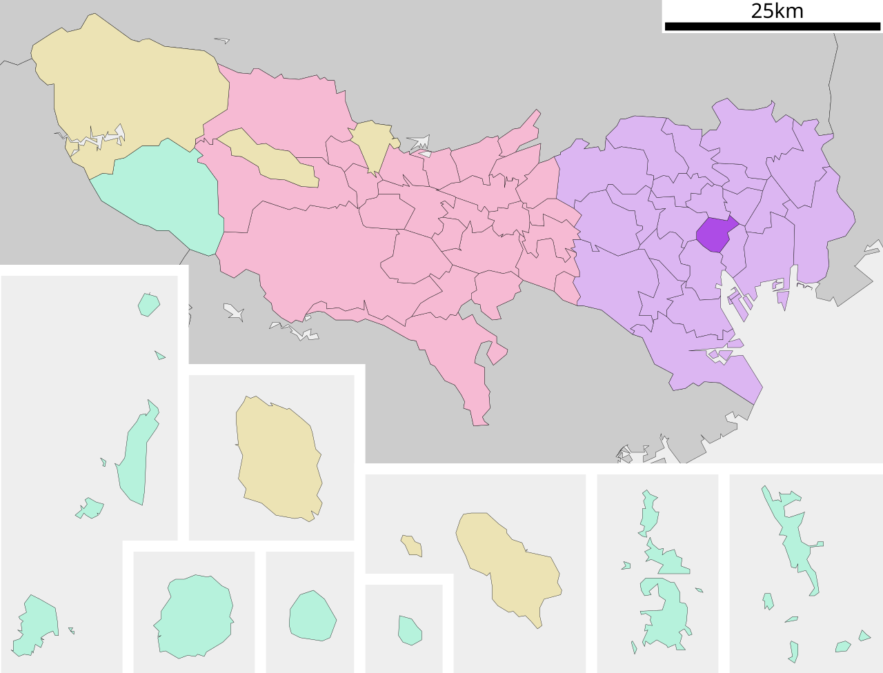
English: Location of Chiyoda-ku in Tokyo Prefecture
日本語: ja:東京都千代田区位置図
วันที่
แหล่งที่มา
Original file: งานของตัว
Data: 国土交通省 国土数値情報(行政区域(N03)・湖沼(W09))
ผู้สร้างสรรค์
Lincun
การอนุญาต (การใช้ไฟล์นี้ใหม่)
This file is a map of a municipality in Japan created and uploaded by Lincun on Japanese Wikipedia. It may also be a file based on one of these maps (see info in file history or author field for more info on later editors). Source:
English: Data used : Ministry of Land, Infrastructure, Transport and Tourism - National Land Numerical Information (Administrative Area (N03) / Lake (W09))
日本語: 使用データ : 国土交通省 国土数値情報(行政区域(N03)・湖沼(W09))
The original file was licensed {{GFDL}} and {{Cc-by-sa-3.0}}. See this category for more files like this. ป้ายนี้มิใช่ป้ายแสดงสถานะลิขสิทธิ์ ดังนั้นการระบุสถานะลิขสิทธิ์จึงต้องกระทำแยกต่างหาก ดูที่ Commons:Lincensing
{{Information| |Description= Location of Chiyoda-ku in Tokyo Prefecture |Source= Japanese wiki [http://ja.wikipedia.org/wiki/%E7%94%BB%E5%83%8F:%E5%9F%BA%E7%A4%8E%E8%87%AA%E6%B2%BB%E4%BD%93%E4%BD%8D%E7%BD%AE%E5%9B%B3_13101.svg] |Date=~~~~~ |Author=[[:j
ไฟล, chiyoda, tokyo, prefecture, ไฟล, ประว, ไฟล, หน, าท, ภาพน, การใช, ไฟล, วนกลาง, อม, ลเก, ยวก, บภาพขนาดของต, วอย, าง, ของไฟล, กเซล, ความละเอ, ยดอ, กเซล, กเซล, กเซล, กเซล, กเซล, ภาพท, ความละเอ, ยดส, งกว, 8206, ไฟล, กเซล, ขนาดไฟล, โลไบต, ปภาพหร, อไฟล, เส, ยงน,. ifl prawtiifl hnathimiphaphni karichiflswnklang khxmulekiywkbphaphkhnadkhxngtwxyang PNG nikhxngifl SVG ni 786 599 phikesl khwamlaexiydxun 315 240 phikesl 630 480 phikesl 1 007 768 phikesl 1 280 976 phikesl 2 560 1 952 phikesl duphaphthimikhwamlaexiydsungkwa 8206 ifl SVG 800 610 phikesl khnadifl 39 kiolibt rupphaphhruxiflesiyngni tnchbbxyuthi khxmmxns raylaexiyddanlang epnkhxkhwamthiaesdngphlcak ifltnchbbinkhxmmxns khxmmxnsepnewbistinokhrngkarsahrbekbrwbrwmsuxesri thi khunsamarthchwyid khwamyx khaxthibayChiyoda ku in Tokyo Prefecture Ja svg English Location of Chiyoda ku in Tokyo Prefecture 日本語 ja 東京都千代田区位置図 wnthi 8 knyayn ph s 2550 aehlngthima Original file ngankhxngtw Data 国土交通省 国土数値情報 行政区域 N03 湖沼 W09 phusrangsrrkh Lincun karxnuyat karichiflniihm This file is a map of a municipality in Japan created and uploaded by Lincun on Japanese Wikipedia It may also be a file based on one of these maps see info in file history or author field for more info on later editors Source English Data used nbsp Ministry of Land Infrastructure Transport and Tourism National Land Numerical Information Administrative Area N03 Lake W09 日本語 使用データ nbsp 国土交通省 国土数値情報 行政区域 N03 湖沼 W09 The original file was licensed GFDL and Cc by sa 3 0 See this category for more files like this paynimiichpayaesdngsthanalikhsiththi dngnnkarrabusthanalikhsiththicungtxngkrathaaeyktanghak duthi Commons Lincensing karxnuyatichsiththi xnuyatihkhdlxk aeckcayaela hruxddaeprexksarniphayitenguxnikhkhxngsyyaxnuyatexksaresrikhxngknu run 1 2 hruxrunid nbcaknithixxkodymulnithisxftaewresri odyimmiswnidhamaekikh immikhxkhwampkhnaaelapkhlng saenakhxngsyyaxnuyatrwmxyuinswnchux syyaxnuyatexksaresrikhxngknuhttp www gnu org copyleft fdl html GFDL GNU Free Documentation License true true iflnixyuphayitsyyaxnuyat khriexthifkhxmmxns aebbaesdngthima xnuyataebbediywkn 3 0 tnchbbkhunsamarth thicaaebngpn thicathasaena aeckcay aelasngngandngklawtxip thicaeriyberiyngihm thicaddaeplngngandngklaw phayitenguxnikhtxipni aesdngthima khuntxngihekiyrtiecakhxngnganxyangehmaasm odyephimlingkipyngsyyaxnuyat aelarabuhakmikarepliynaeplng khunxacthaechnniidinrupaebbidkidtamkhwr aettxngimichinlksnathiaenawaphuihxnuyatsnbsnunkhunhruxkarichngankhxngkhun xnuyataebbediywkn hakkhunddaeplng epliynrup hruxtxetimnganni khuntxngichsyyaxnuyataebbediywknhruxaebbthiehmuxnkbsyyaxnuyatthiichkbnganniethannhttps creativecommons org licenses by sa 3 0 CC BY SA 3 0 Creative Commons Attribution Share Alike 3 0 true true bnthukkarxphohld This file was moved from Japanese Wikipedia See below for original file information File name 基礎自治体位置図 13101 svg Description 基礎自治体位置図画像情報 東京都 千代田区 File history wnthi ewla UTC khnad phuich khwamehn 8 knyayn ph s 2550 23 28 27 800x622 Lincun 基礎自治体位置図画像情報 東京都 千代田区 10 knyayn ph s 2550 11 37 32 800x682 Lincun 基礎自治体位置図画像情報 東京都 千代田区 Page history wnthi ewla UTC Flag phuich khwamyx 8 knyayn ph s 2550 23 28 27 Lincun 基礎自治体位置図画像情報 東京都 千代田区 10 knyayn ph s 2550 11 37 32 Lincun 画像 基礎自治体位置図 13101 svg の新しい版をアップロードしました 基礎自治体位置図画像情報 東京都 千代田区 Deutsch nbsp English nbsp makedonski nbsp 한국어 nbsp 日本語 nbsp فارسی nbsp khabrryayodyyxithyephimkhabrryaythrrthdediywephuxkhyaykhwamwaiflnimixairixethmthiaesdngxyuiniflniprakxbdwysthanalikhsiththimilikhsiththisyyaxnuyatGNU Free Documentation License version 1 2 or later nbsp xngkvsCreative Commons Attribution ShareAlike 3 0 Unported nbsp xngkvs prawtiifl khlikwnthi ewlaephuxduiflthipraktinkhnann wnthi ewlarupyxkhnadphuichkhwamehn pccubn13 20 7 phvscikayn 2563800 610 39 kiolibt AichiWikiFixerUpdate 00 04 22 emsayn 2551800 682 23 kiolibt Krisgrotius Information Description Location of Chiyoda ku in Tokyo Prefecture Source Japanese wiki http ja wikipedia org wiki E7 94 BB E5 83 8F E5 9F BA E7 A4 8E E8 87 AA E6 B2 BB E4 BD 93 E4 BD 8D E7 BD AE E5 9B B3 13101 svg Date Author j 18 37 10 knyayn 2550800 682 23 kiolibt Lincun 基礎自治体位置図画像情報 東京都 千代田区 06 28 9 knyayn 2550800 622 23 kiolibt Lincun 基礎自治体位置図画像情報 東京都 千代田区 hnathimiphaphni hnatxipni oyngmathiphaphni ekhtchioyda karichiflswnklang wikixuntxipniichiflni karichbn ar wikipedia org تشيودا طوكيو karichbn arz wikipedia org تشيودا طوكيو karichbn ca wikipedia org Chiyoda karichbn ce wikipedia org Tiyoda mahsus rajon karichbn da wikipedia org Chiyoda Tokyo karichbn de wikipedia org Chiyoda karichbn en wikipedia org Akihabara Nippon Budokan Imperial Palace Tokyo Tokyo Station Marunouchi Kasumigaseki Nagatachō Yurakuchō Station Akihabara Station Kanda Station Tokyo Nihon University Iidabashi Station Jinbōchō Tokyo Kanda Tokyo National Diet Building Sophia University Meiji University Hosei University Hitotsubashi University Ōtemachi Station Tokyo Tameike sannō Station Nagatachō Station Ōtemachi Tokyo International Forum Yurakuchō Hibiya Station Kokkai gijidō mae Station Kudanshita Station Jimbōchō Station Kasumigaseki Station Tokyo Hibiya High School Ichigaya Station Senshu University Kōjimachi Hibiya Park Iidabashi Surugadai Uchi Kanda Iwamotochō Ogawamachi Tokyo Kajichō Tokyo Banchō Aioichō Tokyo Higashimatsushitachō Tokyo dukarichthwolkephimetimkhxngiflnikhxmulekiywkbphaph phaphnimikhxmulephimetim sungswnihymacakklxngdicitxlhruxsaeknenxrthisamarthekbkhxmuldngklawiwrwmkbphaphid thaphaphnithukprbprungaekikhhruxepliynaeplngcakedim khxmulbangxyangcayngkhngimepliynaeplngehmuxnphaphthithukprbprungaekikhnnchuxeruxngsn東京都行政区画地図khwamkwang800pxkhwamsung610px ekhathungcak https th wikipedia org wiki ifl Chiyoda ku in Tokyo Prefecture Ja svg, wikipedia, วิกิ หนังสือ, หนังสือ, ห้องสมุด,