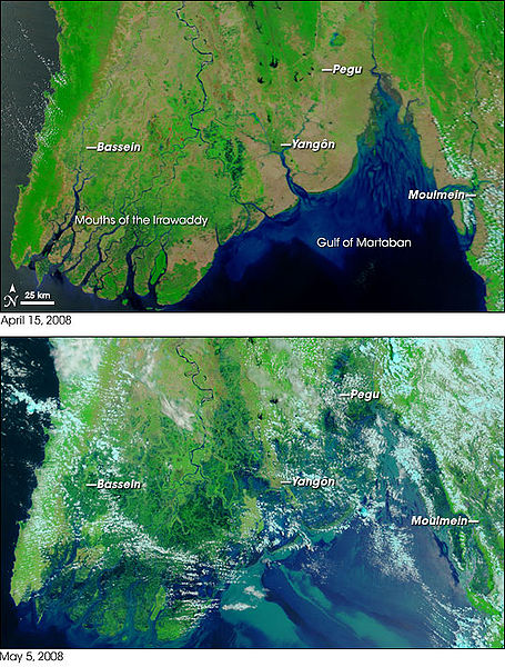
Satellite photos from NASA's w:Terra satellite, showing part of w:Burma/(Myanmar) on April 15, 2008 (top) and May 5, 2008 (bottom), resulting in before-and-after comparisons of the impact from w:Cyclone Nargis.
The first cyclone of the 2008 season in the northern Indian Ocean was a devastating one for Myanmar (Burma). According to reports from Accuweather.com, Cyclone Nargis made landfall with sustained winds of 130 mph and gusts of 150-160 mph, which is the equivalent of a strong Category 3 or minimal Category 4 hurricane. News reports stated that at least 10,000 people were killed, and thousands more were missing as of May 5.
Flood water can be difficult to see in photo-like satellite images, particularly when the water is muddy. This pair of images from the Moderate Resolution Imaging Spectroradiometer (MODIS) on NASA’s Terra satellite use a combination of visible and infrared light to make floodwaters obvious. Water is blue or nearly black, vegetation is bright green, bare ground is tan, and clouds are white or light blue.
On April 15 (top), rivers and lakes are sharply defined against a backdrop of vegetation and fallow agricultural land. The Irrawaddy River flows south through the left-hand side of the image, splitting into numerous distributaries known as the Mouths of the Irrawaddy. The wetlands near the shore are a deep blue green. Cyclone Nargis came ashore across the Mouths of the Irrawaddy and followed the coastline northeast. The entire coastal plain is flooded in the May 5 image (bottom). The fallow agricultural areas appear to have been especially hard hit. For example, Yangôn (population over 4 million) is almost completely surrounded by floods. Several large cities (population 100,000–500,000) are in the affected area. Muddy runoff colors the Gulf of Martaban turquoise.
The high-resolution image provided above is at MODIS’ maximum spatial resolution (level of detail) of 250 meters per pixel. The MODIS Rapid Response Team provides twice-daily images of the region in additional resolutions and formats, including photo-like natural color.
NASA images courtesy the MODIS Rapid Response Team. Caption by Rebecca Lindsey.
References:
BBC. (2008, May 5). Burma’s storm toll ‘nears 4,000.’ Accessed May 5, 2008.
Washburn, D. (2008, May 2). Powerful Cyclone Nargis Slams Myanmar. Accuweather.com. Accessed May 5, 2008.
Unisys. (2008). Cyclone Nargis, Individual Summary. 2008 Hurricane/Tropical Data for Northern Indian Ocean. Accessed May 5, 2008.
{{Information |Description=Satellite photos from NASA's w:Terra satellite, showing part of w:Burma/(Myanmar) on April 15, 2008 (top) and May 5, 2008 (bottom), resulting in before-and-after comparisons of the impact from w:Cyclone Nargis. |Sour
ไฟล, cyclone, nargis, flooding, before, after, ไฟล, ประว, ไฟล, หน, าท, ภาพน, การใช, ไฟล, วนกลาง, อม, ลเก, ยวก, บภาพขนาดของต, วอย, างน, กเซล, ความละเอ, ยดอ, กเซล, กเซล, ภาพท, ความละเอ, ยดส, งกว, 8206, กเซล, ขนาดไฟล, โลไบต, ชน, ดไมม, image, jpeg, ปภาพหร, อไฟล, เ. ifl prawtiifl hnathimiphaphni karichiflswnklang khxmulekiywkbphaphkhnadkhxngtwxyangni 455 600 phikesl khwamlaexiydxun 182 240 phikesl 540 712 phikesl duphaphthimikhwamlaexiydsungkwa 8206 540 712 phikesl khnadifl 137 kiolibt chnidimm image jpeg rupphaphhruxiflesiyngni tnchbbxyuthi khxmmxns raylaexiyddanlang epnkhxkhwamthiaesdngphlcak ifltnchbbinkhxmmxns khxmmxnsepnewbistinokhrngkarsahrbekbrwbrwmsuxesri thi khunsamarthchwyid khwamyx khaxthibayCyclone Nargis flooding before and after jpg Satellite photos from NASA s w Terra satellite showing part of w Burma Myanmar on April 15 2008 top and May 5 2008 bottom resulting in before and after comparisons of the impact from w Cyclone Nargis The first cyclone of the 2008 season in the northern Indian Ocean was a devastating one for Myanmar Burma According to reports from Accuweather com Cyclone Nargis made landfall with sustained winds of 130 mph and gusts of 150 160 mph which is the equivalent of a strong Category 3 or minimal Category 4 hurricane News reports stated that at least 10 000 people were killed and thousands more were missing as of May 5 Flood water can be difficult to see in photo like satellite images particularly when the water is muddy This pair of images from the Moderate Resolution Imaging Spectroradiometer MODIS on NASA s Terra satellite use a combination of visible and infrared light to make floodwaters obvious Water is blue or nearly black vegetation is bright green bare ground is tan and clouds are white or light blue On April 15 top rivers and lakes are sharply defined against a backdrop of vegetation and fallow agricultural land The Irrawaddy River flows south through the left hand side of the image splitting into numerous distributaries known as the Mouths of the Irrawaddy The wetlands near the shore are a deep blue green Cyclone Nargis came ashore across the Mouths of the Irrawaddy and followed the coastline northeast The entire coastal plain is flooded in the May 5 image bottom The fallow agricultural areas appear to have been especially hard hit For example Yangon population over 4 million is almost completely surrounded by floods Several large cities population 100 000 500 000 are in the affected area Muddy runoff colors the Gulf of Martaban turquoise The high resolution image provided above is at MODIS maximum spatial resolution level of detail of 250 meters per pixel The MODIS Rapid Response Team provides twice daily images of the region in additional resolutions and formats including photo like natural color NASA images courtesy the MODIS Rapid Response Team Caption by Rebecca Lindsey References BBC 2008 May 5 Burma s storm toll nears 4 000 Accessed May 5 2008 Washburn D 2008 May 2 Powerful Cyclone Nargis Slams Myanmar Accuweather com Accessed May 5 2008 Unisys 2008 Cyclone Nargis Individual Summary 2008 Hurricane Tropical Data for Northern Indian Ocean Accessed May 5 2008 wnthi 5 phvsphakhm ph s 2551aehlngthima NASA Earth Observatoryphusrangsrrkh MODIS Rapid Response Project at NASA GSFCkarxnuyat karichiflniihm Public domain Public domain false falsephaphniepnsatharnsmbti enuxngcakepnphaphthisrangkhunodyxngkhkarbriharkarbinaelaxwkasaehngchati NASA sungtamnoybaydanlikhsiththikhxngnasarabuiwwa phaphaelasuxtang khxngnasaimidrbkarkhumkhrxngodylikhsiththiykewncarabuiwwamilikhsiththi duephimthi hnanoybaydanlikhsiththikhxngnasa hrux noybaykarichphaphkhxng JPLkhaetuxn karich olokkhxngnasa ekhruxnghmayaelaekhruxngpradbkhxngnasa thukcakddwykdhmayshrthxemrikainlksna 14 khxngkhxbngkhbthangrachkarshrthxemrika swnthi 1221 ewbistkhxngnasaekbrwbrwmphaphthimacakxngkhkarxwkasosewiyt xngkhkarxwkasaehngchatirsesiy aelaxngkhkarxwkasthimiichxngkhkarxwkaskhxngshrthxemrika epncanwnmak phaphehlaniimcaepntxngepnsatharnsmbtiesmxip phaphhruxsuxthimacak klxngothrthrrsnxwkashbebil xacmilikhsiththi hakphaphhruxsuxnnimidrabuchdecnwamacak sthabnwithyasastrklxngothrthrrsnxwkas 1 phaphhruxsuxthnghmdthimacakekhruxngmuxkhxng okhrngkarsuksadwngxathityaelalmsuriya milikhsiththi karnaphaphhruxsuxcakokhrngkaripichnxkehnuxcakkarichephuxkarkhahruxephuxkarsuksa txngidrbxnuyatkxn 2 phaphthithukkhdeluxkihepn phaphdarasastrpracawn APOD bnewbistkhxng APOD xacmilikhsiththi 3 ewxrchnxun iflxunthiichiflni Cyclone Nargis flooding before and after Gif gif none karxnuyatichsiththi Public domain Public domain false falsephaphniepnsatharnsmbti enuxngcakepnphaphthisrangkhunodyxngkhkarbriharkarbinaelaxwkasaehngchati NASA sungtamnoybaydanlikhsiththikhxngnasarabuiwwa phaphaelasuxtang khxngnasaimidrbkarkhumkhrxngodylikhsiththiykewncarabuiwwamilikhsiththi duephimthi hnanoybaydanlikhsiththikhxngnasa hrux noybaykarichphaphkhxng JPLkhaetuxn karich olokkhxngnasa ekhruxnghmayaelaekhruxngpradbkhxngnasa thukcakddwykdhmayshrthxemrikainlksna 14 khxngkhxbngkhbthangrachkarshrthxemrika swnthi 1221 ewbistkhxngnasaekbrwbrwmphaphthimacakxngkhkarxwkasosewiyt xngkhkarxwkasaehngchatirsesiy aelaxngkhkarxwkasthimiichxngkhkarxwkaskhxngshrthxemrika epncanwnmak phaphehlaniimcaepntxngepnsatharnsmbtiesmxip phaphhruxsuxthimacak klxngothrthrrsnxwkashbebil xacmilikhsiththi hakphaphhruxsuxnnimidrabuchdecnwamacak sthabnwithyasastrklxngothrthrrsnxwkas 4 phaphhruxsuxthnghmdthimacakekhruxngmuxkhxng okhrngkarsuksadwngxathityaelalmsuriya milikhsiththi karnaphaphhruxsuxcakokhrngkaripichnxkehnuxcakkarichephuxkarkhahruxephuxkarsuksa txngidrbxnuyatkxn 5 phaphthithukkhdeluxkihepn phaphdarasastrpracawn APOD bnewbistkhxng APOD xacmilikhsiththi 6 khabrryayodyyxithyephimkhabrryaythrrthdediywephuxkhyaykhwamwaiflnimixairixethmthiaesdngxyuiniflniprakxbdwywnthisrang wnkxtng5 phvsphakhm 2008 prawtiifl khlikwnthi ewlaephuxduiflthipraktinkhnann wnthi ewlarupyxkhnadphuichkhwamehn pccubn08 52 6 phvsphakhm 2551540 712 137 kiolibt Miss Madeline commonswiki Information Description Satellite photos from NASA 039 s w Terra satellite showing part of w Burma Myanmar on April 15 2008 top and May 5 2008 bottom resulting in before and after comparisons of the impact from w Cyclone Nargis Sour hnathimiphaphni hnatxipni oyngmathiphaphni ehtukarnphayuhmunnarkis ph s 2551 karichiflswnklang wikixuntxipniichiflni karichbn ca wikipedia org Delta fluvial Ciclo Nargis karichbn cy wikipedia org Effeithiau newid hinsawdd ar bobl karichbn de wikipedia org 2 Mai Zyklon Nargis Hilfe Diskussion Bilder Kollagen und Mehrfachbilder karichbn de wikinews org Zyklon Nargis Zahl der Opfer steigt weiter karichbn en wikipedia org Ayeyarwady Region Effects of climate change Cyclone Nargis Irrawaddy Delta karichbn en wikinews org Myanmar to allow foreign aid says UN s Ban Ki Moon karichbn es wikipedia org Delta fluvial Ciclon Nargis Efectos del calentamiento global sobre las personas karichbn fr wikipedia org Cyclone Nargis karichbn fr wikinews org Le bilan humain du cyclone Nargis revu largement a la hausse karichbn it wikipedia org Delta fluviale Delta dell Irrawaddy karichbn ko wikipedia org 사이클론 나르기스 테라 우주선 karichbn la wikipedia org 2008 Typhon Nargis karichbn meta wikimedia org Wiki99 agriculture karichbn my wikipedia org ဧရ ဝတ မ စ ဝက န ပ ဒ သ karichbn nl wikipedia org Irrawaddy Nargis cycloon karichbn no wikipedia org Syklonen Nargis karichbn pl wikipedia org Dyskusja wikipedysty Grompel archiwum 2011 04 09 Delta Irawadi karichbn pt wikipedia org Ciclone Nargis Usuario a CaveatLector2022 Efeitos das alteracoes climaticas Efeitos das alteracoes climaticas karichbn ru wikipedia org Uchastnik Eligatron Illyustracii dlya statej o kosmonavtike 12 karichbn sco wikipedia org 2 Mey karichbn simple wikipedia org Cyclone Nargis karichbn si wikipedia org න ර ග ස ස ළ ක ණ ට ව න ව න ශයට පත ව බ ර මය භ ම ස ත යම karichbn sv wikipedia org Tropiska cyklonen Nargis karichbn sv wikinews org Cyklonen Nargis kravt over 100 000 dodsoffer karichbn uk wikipedia org Andamanske more karichbn vi wikipedia org Bao Nargis karichbn www wikidata org Q43197 Q152314 Q1430548 Q3705234 karichbn zh wikipedia org 气旋纳尔吉斯khxmulekiywkbphaph phaphnimikhxmulephimetim sungswnihymacakklxngdicitxlhruxsaeknenxrthisamarthekbkhxmuldngklawiwrwmkbphaphid thaphaphnithukprbprungaekikhhruxepliynaeplngcakedim khxmulbangxyangcayngkhngimepliynaeplngehmuxnphaphthithukprbprungaekikhnn error0 ekhathungcak https th wikipedia org wiki ifl Cyclone Nargis flooding before and after jpg, wikipedia, วิกิ หนังสือ, หนังสือ, ห้องสมุด,