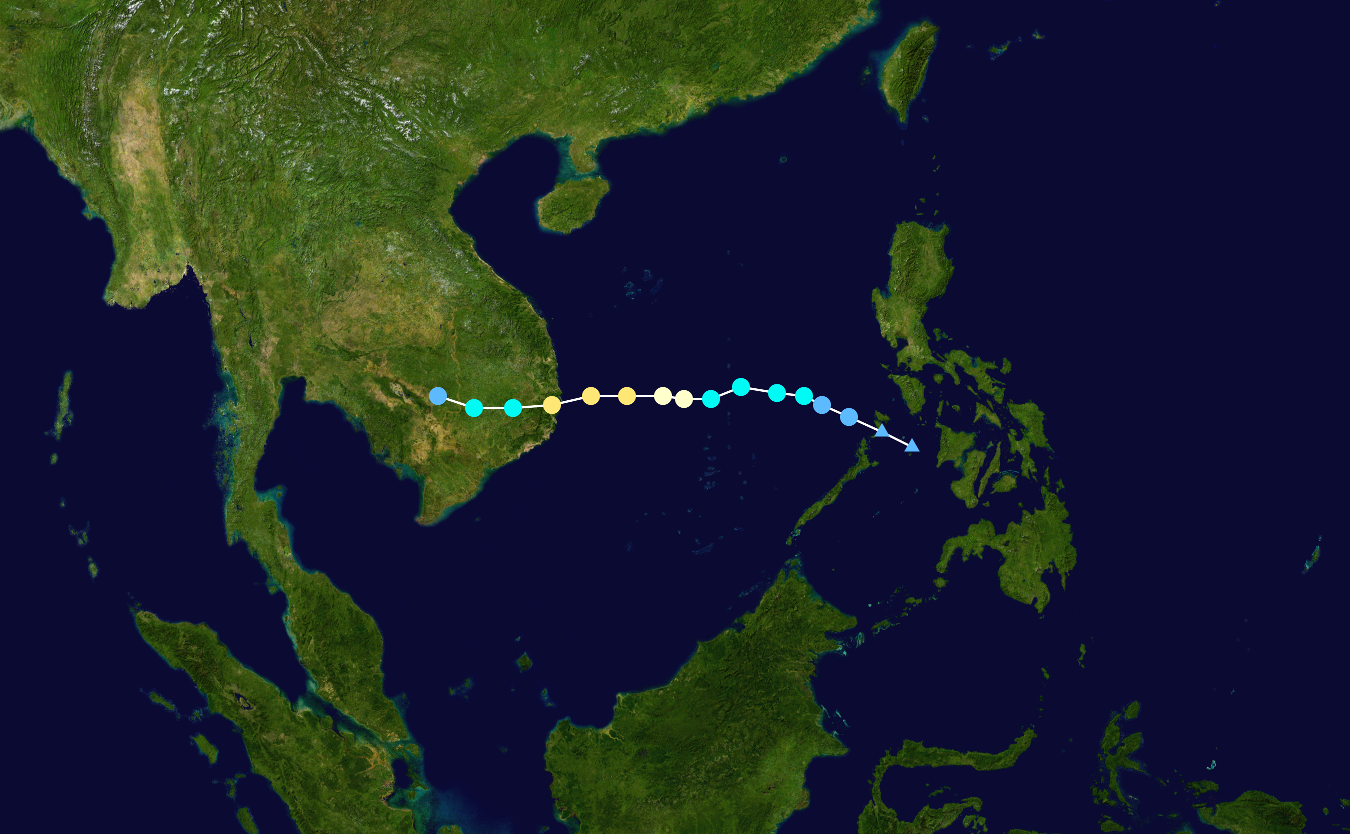
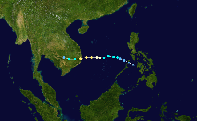
fbpx
วิกิพีเดีย

Damrey 2017 track

ดูภาพที่มีความละเอียดสูงกว่า(2,700 × 1,669 พิกเซล, ขนาดไฟล์: 3.02 เมกะไบต์, ชนิดไมม์: image/png)

รูปภาพหรือไฟล์เสียงนี้ ต้นฉบับอยู่ที่ คอมมอนส์ รายละเอียดด้านล่าง เป็นข้อความที่แสดงผลจาก ไฟล์ต้นฉบับในคอมมอนส์
คอมมอนส์เป็นเว็บไซต์ในโครงการสำหรับเก็บรวบรวมสื่อเสรี ที่ คุณสามารถช่วยได้

ความย่อ

คำอธิบาย
English: Track map of Typhoon Damrey of the 2017 Pacific typhoon season. The points show the location of the storm at 6-hour intervals. The colour represents the storm's maximum sustained wind speeds as classified in the Saffir–Simpson scale (see below), and the shape of the data points represent the nature of the storm, according to the legend below.

Saffir–Simpson scale

 
Tropical depression (≤38 mph, ≤62 km/h)
 
Tropical storm (39–73 mph, 63–118 km/h)
 
Category 1 (74–95 mph, 119–153 km/h)
 
Category 2 (96–110 mph, 154–177 km/h)
 
Category 3 (111–129 mph, 178–208 km/h)
 
Category 4 (130–156 mph, 209–251 km/h)
 
Category 5 (≥157 mph, ≥252 km/h)
 
Unknown

Storm type

Tropical cyclone
Subtropical cyclone
Extratropical cyclone / Remnant low / Tropical disturbance / Monsoon depression
วันที่ 2017-11-01–2017-11-05
แหล่งที่มา Created by Meow using WikiProject Tropical cyclones/Tracks. The background image is from NASA. Tracking data is from the Joint Typhoon Warning Center[1].
ผู้สร้างสรรค์ Meow
Source code
InfoField
Track map data table, if present below, is in HURDAT2 or ATCF format. See format details in [2] and [3].
Track map generator input code
WP352017, DAMREY, 16, 20171101, 0000, , DB, 11.1N, 121.1E, 15, 1005, 0, 0, 0, 0, 0, 0, 0, 0, 0, 0, 0, 0, JTWC, 20171101, 0600, , DB, 11.6N, 120.1E, 20, 1004, 0, 0, 0, 0, 0, 0, 0, 0, 0, 0, 0, 0, JTWC, 20171101, 1200, , TD, 12.1N, 119.0E, 25, 1003, 0, 0, 0, 0, 0, 0, 0, 0, 0, 0, 0, 0, JTWC, 20171101, 1800, , TD, 12.5N, 118.1E, 30, 1000, 0, 0, 0, 0, 0, 0, 0, 0, 0, 0, 0, 0, JTWC, 20171102, 0000, , TS, 12.8N, 117.5E, 35, 998, 50, 30, 0, 0, 0, 0, 0, 0, 0, 0, 0, 0, JTWC, 20171102, 0600, , TS, 12.9N, 116.6E, 45, 995, 60, 30, 30, 60, 0, 0, 0, 0, 0, 0, 0, 0, JTWC, 20171102, 1200, , TS, 13.1N, 115.4E, 50, 992, 80, 50, 50, 70, 30, 0, 0, 30, 0, 0, 0, 0, JTWC, 20171102, 1800, , TS, 12.7N, 114.4E, 60, 986, 110, 60, 70, 110, 40, 30, 40, 40, 0, 0, 0, 0, JTWC, 20171103, 0000, , TY, 12.7N, 113.5E, 70, 978, 120, 100, 90, 120, 50, 50, 60, 60, 30, 0, 0, 30, JTWC, 20171103, 0600, , TY, 12.8N, 112.8E, 75, 970, 120, 100, 100, 120, 80, 60, 60, 80, 50, 30, 30, 50, JTWC, 20171103, 1200, , TY, 12.8N, 111.6E, 85, 966, 120, 100, 110, 130, 80, 60, 60, 80, 50, 40, 40, 50, JTWC, 20171103, 1800, , TY, 12.8N, 110.4E, 90, 965, 150, 80, 60, 150, 60, 50, 50, 70, 50, 40, 40, 50, JTWC, 20171104, 0000, , TY, 12.5N, 109.1E, 85, 975, 140, 70, 50, 120, 50, 40, 40, 50, 40, 30, 30, 40, JTWC, 20171104, 0600, , TS, 12.4N, 107.8E, 55, 988, 100, 0, 0, 90, 30, 0, 0, 30, 0, 0, 0, 0, JTWC, 20171104, 1200, , TS, 12.4N, 106.5E, 40, 998, 70, 0, 0, 50, 0, 0, 0, 0, 0, 0, 0, 0, JTWC, 20171104, 1800, , TD, 12.8N, 105.3E, 30, 1005, 0, 0, 0, 0, 0, 0, 0, 0, 0, 0, 0, 0, JTWC, 

การอนุญาตใช้สิทธิ

คำบรรยายโดยย่อ

เพิ่มคำบรรยายทรรทัดเดียวเพื่อขยายความว่าไฟล์นี้มีอะไร

ไอเทมที่แสดงอยู่ในไฟล์นี้

ประกอบด้วย

สถานะลิขสิทธิ์

copyrighted, dedicated to the public domain by copyright holder อังกฤษ

สัญญาอนุญาต

released into the public domain by the copyright holder อังกฤษ

MIME type อังกฤษ

image/png

ประวัติไฟล์

คลิกวันที่/เวลาเพื่อดูไฟล์ที่ปรากฏในขณะนั้น

วันที่/เวลารูปย่อขนาดผู้ใช้ความเห็น
ปัจจุบัน07:55, 24 มกราคม 25632,700 × 1,669 (3.02 เมกะไบต์)SupportstormJTWC data
06:14, 22 เมษายน 25622,700 × 1,669 (3.15 เมกะไบต์)SupportstormIBTrACS version
21:04, 6 พฤศจิกายน 25602,700 × 1,669 (2.96 เมกะไบต์)Meow11-05 00Z (operationally final)
21:29, 4 พฤศจิกายน 25602,700 × 1,669 (2.92 เมกะไบต์)Meow11-04 12Z
21:14, 3 พฤศจิกายน 25602,700 × 1,669 (2.79 เมกะไบต์)Meow11-03 12Z
20:42, 2 พฤศจิกายน 25602,700 × 1,669 (2.67 เมกะไบต์)Meow{{Current}} {{WPTC track map | author = Meow | name = Tropical Storm Damrey | article = 2017 Pacific typhoon season#Tropical Storm Damrey (Ramil) | season = 2017 Pacific typhoon season | start = 2017-10-31 | end = | othersource=[http://ftp.emc....

หน้าต่อไปนี้ โยงมาที่ภาพนี้:

การใช้ไฟล์ส่วนกลาง

วิกิอื่นต่อไปนี้ใช้ไฟล์นี้:

  • Typhoon Damrey (2017)
  • User:Tfmbty/2017 Pacific typhoon season
  • User:Nino Marakot/2017 Pacific typhoon season
  • 틀:태풍 정보 (소)/설명문서
  • 2017년 태풍
  • 2017년 북서태평양 열대저압부
  • 태풍 담레이 (2017년)
  • 틀:활동중인 태풍 (소)
  • 틀:활동중인 태풍 (소)/설명문서
  • Сезон тихоокеанских тайфунов 2017 года
  • Bão Damrey (2017)
  • 颱風達維 (2017年)
  • ไฟล, damrey, 2017, track, ไฟล, ประว, ไฟล, หน, าท, ภาพน, การใช, ไฟล, วนกลางขนาดของต, วอย, างน, กเซล, ความละเอ, ยดอ, กเซล, กเซล, กเซล, กเซล, กเซล, ภาพท, ความละเอ, ยดส, งกว, 8206, กเซล, ขนาดไฟล, เมกะไบต, ชน, ดไมม, image, ปภาพหร, อไฟล, เส, ยงน, นฉบ, บอย, คอมมอนส, . ifl prawtiifl hnathimiphaphni karichiflswnklangkhnadkhxngtwxyangni 800 495 phikesl khwamlaexiydxun 320 198 phikesl 640 396 phikesl 1 024 633 phikesl 1 280 791 phikesl 2 700 1 669 phikesl duphaphthimikhwamlaexiydsungkwa 8206 2 700 1 669 phikesl khnadifl 3 02 emkaibt chnidimm image png rupphaphhruxiflesiyngni tnchbbxyuthi khxmmxns raylaexiyddanlang epnkhxkhwamthiaesdngphlcak ifltnchbbinkhxmmxns khxmmxnsepnewbistinokhrngkarsahrbekbrwbrwmsuxesri thi khunsamarthchwyid khwamyx khaxthibayDamrey 2017 track png English Track map of Typhoon Damrey of the 2017 Pacific typhoon season The points show the location of the storm at 6 hour intervals The colour represents the storm s maximum sustained wind speeds as classified in the Saffir Simpson scale see below and the shape of the data points represent the nature of the storm according to the legend below Saffir Simpson scale Tropical depression 38 mph 62 km h Tropical storm 39 73 mph 63 118 km h Category 1 74 95 mph 119 153 km h Category 2 96 110 mph 154 177 km h Category 3 111 129 mph 178 208 km h Category 4 130 156 mph 209 251 km h Category 5 157 mph 252 km h Unknown Storm type Tropical cyclone Subtropical cyclone Extratropical cyclone Remnant low Tropical disturbance Monsoon depressionwnthi 2017 11 01 2017 11 05aehlngthima Created by Meow using WikiProject Tropical cyclones Tracks The background image is from NASA Tracking data is from the Joint Typhoon Warning Center 1 phusrangsrrkh MeowSource codeInfoFieldTrack map data table if present below is in HURDAT2 or ATCF format See format details in 2 and 3 Track map generator input codeWP352017 DAMREY 16 20171101 0000 DB 11 1N 121 1E 15 1005 0 0 0 0 0 0 0 0 0 0 0 0 JTWC 20171101 0600 DB 11 6N 120 1E 20 1004 0 0 0 0 0 0 0 0 0 0 0 0 JTWC 20171101 1200 TD 12 1N 119 0E 25 1003 0 0 0 0 0 0 0 0 0 0 0 0 JTWC 20171101 1800 TD 12 5N 118 1E 30 1000 0 0 0 0 0 0 0 0 0 0 0 0 JTWC 20171102 0000 TS 12 8N 117 5E 35 998 50 30 0 0 0 0 0 0 0 0 0 0 JTWC 20171102 0600 TS 12 9N 116 6E 45 995 60 30 30 60 0 0 0 0 0 0 0 0 JTWC 20171102 1200 TS 13 1N 115 4E 50 992 80 50 50 70 30 0 0 30 0 0 0 0 JTWC 20171102 1800 TS 12 7N 114 4E 60 986 110 60 70 110 40 30 40 40 0 0 0 0 JTWC 20171103 0000 TY 12 7N 113 5E 70 978 120 100 90 120 50 50 60 60 30 0 0 30 JTWC 20171103 0600 TY 12 8N 112 8E 75 970 120 100 100 120 80 60 60 80 50 30 30 50 JTWC 20171103 1200 TY 12 8N 111 6E 85 966 120 100 110 130 80 60 60 80 50 40 40 50 JTWC 20171103 1800 TY 12 8N 110 4E 90 965 150 80 60 150 60 50 50 70 50 40 40 50 JTWC 20171104 0000 TY 12 5N 109 1E 85 975 140 70 50 120 50 40 40 50 40 30 30 40 JTWC 20171104 0600 TS 12 4N 107 8E 55 988 100 0 0 90 30 0 0 30 0 0 0 0 JTWC 20171104 1200 TS 12 4N 106 5E 40 998 70 0 0 50 0 0 0 0 0 0 0 0 JTWC 20171104 1800 TD 12 8N 105 3E 30 1005 0 0 0 0 0 0 0 0 0 0 0 0 JTWC karxnuyatichsiththi Public domain Public domain false falsenganniidthukephyaephrsusatharnsmbtiodyecakhxng Meow sungmiphlthwolkinbangpraeths karkrathadngklawxacimsamarththaidtamkdhmayMeow xnuyatihthukkhnmisiththiinkarichiflniinthukehtuphlkarich odyimmimienguxnikh ewnaetkdhmayimxnuyatihthaechnnnkhabrryayodyyxithyephimkhabrryaythrrthdediywephuxkhyaykhwamwaiflnimixairixethmthiaesdngxyuiniflniprakxbdwysthanalikhsiththicopyrighted dedicated to the public domain by copyright holder xngkvssyyaxnuyatreleased into the public domain by the copyright holder xngkvsMIME type xngkvsimage png prawtiifl khlikwnthi ewlaephuxduiflthipraktinkhnann wnthi ewlarupyxkhnadphuichkhwamehn pccubn07 55 24 mkrakhm 25632 700 1 669 3 02 emkaibt SupportstormJTWC data 06 14 22 emsayn 25622 700 1 669 3 15 emkaibt SupportstormIBTrACS version 21 04 6 phvscikayn 25602 700 1 669 2 96 emkaibt Meow11 05 00Z operationally final 21 29 4 phvscikayn 25602 700 1 669 2 92 emkaibt Meow11 04 12Z 21 14 3 phvscikayn 25602 700 1 669 2 79 emkaibt Meow11 03 12Z 20 42 2 phvscikayn 25602 700 1 669 2 67 emkaibt Meow Current WPTC track map author Meow name Tropical Storm Damrey article 2017 Pacific typhoon season Tropical Storm Damrey Ramil season 2017 Pacific typhoon season start 2017 10 31 end othersource http ftp emc hnathimiphaphni hnatxipni oyngmathiphaphni vduphayuitfunaepsifik ph s 2560 karichiflswnklang wikixuntxipniichiflni karichbn bcl wikipedia org Bagyong Damrey 2017 karichbn cs wikipedia org Tajfun Damrey karichbn en wikipedia org 2017 Pacific typhoon season Typhoon Damrey 2017 User Tfmbty 2017 Pacific typhoon season User Nino Marakot 2017 Pacific typhoon season karichbn ja wikipedia org 2017年の台風 karichbn ko wikipedia org 틀 태풍 정보 소 틀 태풍 정보 소 설명문서 2017년 태풍 2017년 북서태평양 열대저압부 태풍 담레이 2017년 틀 활동중인 태풍 소 틀 활동중인 태풍 소 설명문서 karichbn pt wikipedia org Temporada de tufoes no Pacifico de 2017 karichbn ru wikipedia org Uchastnik Eligatron Sezon tihookeanskih tajfunov 2017 Sezon tihookeanskih tajfunov 2017 goda karichbn tl wikipedia org Panahon ng bagyo sa Pasipiko ng 2017 karichbn vi wikipedia org Mua bao Tay Bắc Thai Binh Dương 2017 Bao Damrey 2017 karichbn www wikidata org Q42639235 karichbn zh wikipedia org 2017年太平洋颱風季 颱風達維 2017年 ekhathungcak https th wikipedia org wiki ifl Damrey 2017 track png, wikipedia, วิกิ หนังสือ, หนังสือ, ห้องสมุด,

    บทความ

    , อ่าน, ดาวน์โหลด, ฟรี, ดาวน์โหลดฟรี, mp3, วิดีโอ, mp4, 3gp, jpg, jpeg, gif, png, รูปภาพ, เพลง, เพลง, หนัง, หนังสือ, เกม, เกม