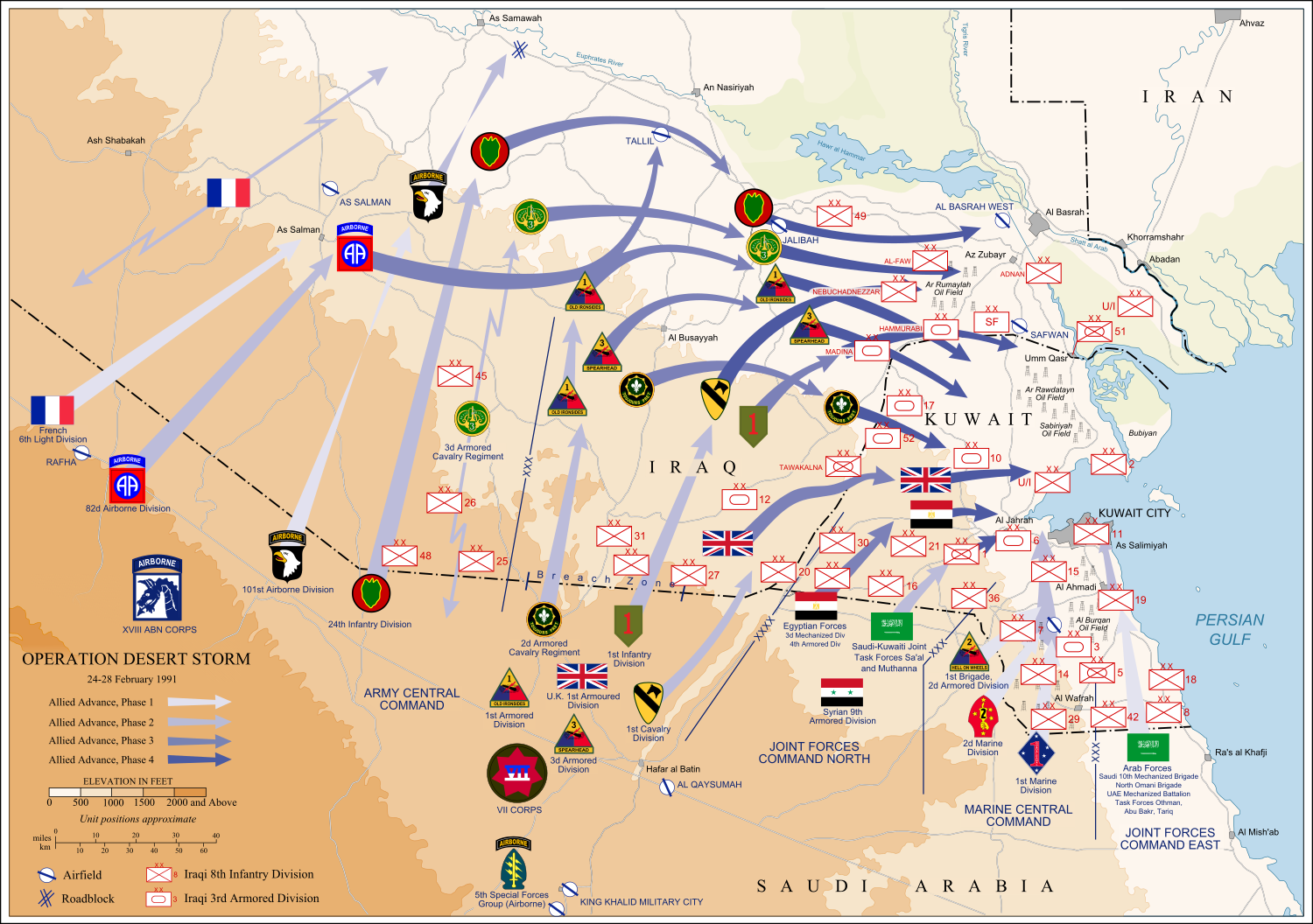
English: Map of ground operations of Operation Desert Storm starting invasion February 24-28th 1991. Shows allied and Iraqi forces. Special arrows indicate the American 101st Airborne division moved by air and where the French 6st light division and American 3rd Armored Cavalry Regiment provided security.
Français : Carte montrant les opérations terrestres menées lors de l'opération Tempête du désert entre le 24 et le 28 février 1991 : les positions tenues par les armées irakienne et alliées, et les mouvements de cette dernière. Des flèches particulières indiquent les manœuvres héliportées pratiquées par la 101e division aéroportée, ainsi que les zones sécurisées par la 6e brigade légère blindée française et par le 3e régiment blindé de cavalerie américain.
วันที่
(UTC)
แหล่งที่มา
self-vectored from Image:Operation Desert Storm.jpg from this site and this site.
This file is licensed under the Creative Commons Attribution-Share Alike 4.0 International, 3.0 Unported, 2.5 Generic, 2.0 Generic and 1.0 Generic license.
== Summary == {{Inkscape}} {{Information |Description=Map of ground operations of Operation Desert Storm from February 24-28th 1991. Shows allied and Iraqi forces. |Source=self-made, vectored from Image:Operation Desert Storm.jpg from [http://www.his
ไฟล, desertstormmap, ไฟล, ประว, ไฟล, หน, าท, ภาพน, การใช, ไฟล, วนกลาง, อม, ลเก, ยวก, บภาพขนาดของต, วอย, าง, ของไฟล, กเซล, ความละเอ, ยดอ, กเซล, กเซล, กเซล, กเซล, กเซล, กเซล, ภาพท, ความละเอ, ยดส, งกว, 8206, ไฟล, กเซล, ขนาดไฟล, เมกะไบต, ปภาพหร, อไฟล, เส, ยงน, นฉบ. ifl prawtiifl hnathimiphaphni karichiflswnklang khxmulekiywkbphaphkhnadkhxngtwxyang PNG nikhxngifl SVG ni 800 563 phikesl khwamlaexiydxun 320 225 phikesl 640 451 phikesl 1 024 721 phikesl 1 280 901 phikesl 2 560 1 802 phikesl 1 500 1 056 phikesl duphaphthimikhwamlaexiydsungkwa 8206 ifl SVG 1 500 1 056 phikesl khnadifl 3 13 emkaibt rupphaphhruxiflesiyngni tnchbbxyuthi khxmmxns raylaexiyddanlang epnkhxkhwamthiaesdngphlcak ifltnchbbinkhxmmxns khxmmxnsepnewbistinokhrngkarsahrbekbrwbrwmsuxesri thi khunsamarthchwyid nikhuxphaphkhdsrrinwikimiediykhxmmxns Featured pictures aela khux thuxwaepn phaphxyangidxyanghnungthidithisud nikhuxphaphkhdsrrinwikiphiediyphasaxngkvs Featured pictures aela khux thuxwaepn phaphxyangidxyanghnungthidithisudhakkhunmiphaphthimikhunphaph khlaykhlungkn thicasamarthephyaephridtam syyaxnuyatthiehmaasm ihaenicwa khunid xpohld kahndsyyaxnuyat aelaid esnxchuxaelw khwamyx iflphaphkrafiksewketxrimidrabukartrwcody W3C ni srangkhunodyich Inkscape khaxthibayDesertStormMap v2 svg English Map of ground operations of Operation Desert Storm starting invasion February 24 28th 1991 Shows allied and Iraqi forces Special arrows indicate the American 101st Airborne division moved by air and where the French 6st light division and American 3rd Armored Cavalry Regiment provided security Francais Carte montrant les operations terrestres menees lors de l operation Tempete du desert entre le 24 et le 28 fevrier 1991 les positions tenues par les armees irakienne et alliees et les mouvements de cette derniere Des fleches particulieres indiquent les manœuvres heliportees pratiquees par la 101e division aeroportee ainsi que les zones securisees par la 6e brigade legere blindee francaise et par le 3e regiment blinde de cavalerie americain wnthi 4 kumphaphnth ph s 2551 21 00 UTC aehlngthima self vectored from Image Operation Desert Storm jpg from this site and this site phusrang Jeff Dahlphikdxangxingthangphumisastr rabuphikdbnaephnthi Wikimaps Warper thamikhwamimehmaasm krunatng warp status skip ephuxsxnewxrchnxun File Desert Storm Map svg karxnuyatichsiththi khapheca inthanaphuthuxlikhsiththikhxngphaphhruxsuxni xnuyatihichphaphhruxsuxniphayitenguxnikhtxipni xnuyatihkhdlxk aeckcayaela hruxddaeprexksarniphayitenguxnikhkhxngsyyaxnuyatexksaresrikhxngknu run 1 2 hruxrunid nbcaknithixxkodymulnithisxftaewresri odyimmiswnidhamaekikh immikhxkhwampkhnaaelapkhlng saenakhxngsyyaxnuyatrwmxyuinswnchux syyaxnuyatexksaresrikhxngknuhttp www gnu org copyleft fdl html GFDL GNU Free Documentation License true trueThis file is licensed under the Creative Commons Attribution Share Alike 4 0 International 3 0 Unported 2 5 Generic 2 0 Generic and 1 0 Generic license khunsamarth thicaaebngpn thicathasaena aeckcay aelasngngandngklawtxip thicaeriyberiyngihm thicaddaeplngngandngklaw phayitenguxnikhtxipni aesdngthima khuntxngihekiyrtiecakhxngnganxyangehmaasm odyephimlingkipyngsyyaxnuyat aelarabuhakmikarepliynaeplng khunxacthaechnniidinrupaebbidkidtamkhwr aettxngimichinlksnathiaenawaphuihxnuyatsnbsnunkhunhruxkarichngankhxngkhun xnuyataebbediywkn hakkhunddaeplng epliynrup hruxtxetimnganni khuntxngichsyyaxnuyataebbediywknhruxaebbthiehmuxnkbsyyaxnuyatthiichkbnganniethannhttps creativecommons org licenses by sa 4 0 CC BY SA 4 0 Creative Commons Attribution Share Alike 4 0 true truekhunsamartheluxksyyaxnuyatdngklawtamtxngkarkhabrryayodyyxithyxngkidfrngessTempete du desertixethmthiaesdngxyuiniflniprakxbdwyphusrangbangkhathiimmiixethmwikisnethsyuxaraexl https commons wikimedia org wiki user Jeff Dahlchuxphuichwikimiediy Jeff Dahlhnathikhxngwtthuphayitpraphcnni changphaphchuxphusrangsrrkh Jeff DahlsthanalikhsiththimilikhsiththisyyaxnuyatCreative Commons Attribution ShareAlike 2 5 Generic xngkvsCreative Commons Attribution ShareAlike 1 0 Generic xngkvsCreative Commons Attribution ShareAlike 4 0 International xngkvsGNU Free Documentation License version 1 2 or later xngkvsCreative Commons Attribution ShareAlike 3 0 Unported xngkvsCreative Commons Attribution ShareAlike 2 0 Generic xngkvsCommons quality assessment xngkvsWikimedia Commons featured picture xngkvswnthisrang wnkxtng4 kumphaphnth 2008MIME type xngkvsimage svg xml prawtiifl khlikwnthi ewlaephuxduiflthipraktinkhnann wnthi ewlarupyxkhnadphuichkhwamehn pccubn20 14 9 mithunayn 25551 500 1 056 3 13 emkaibt Coollanduploaded with x external editor 11 31 6 kumphaphnth 25511 500 1 056 3 13 emkaibt Jeff Dahlflags label edits 04 00 5 kumphaphnth 25511 500 1 056 2 89 emkaibt Jeff Dahl Summary Inkscape Information Description Map of ground operations of Operation Desert Storm from February 24 28th 1991 Shows allied and Iraqi forces Source self made vectored from Image Operation Desert Storm jpg from http www his hnathimiphaphni hnatxipni oyngmathiphaphni sngkhramxaw karichiflswnklang wikixuntxipniichiflni karichbn an wikipedia org Arabia Saudi karichbn ar wikipedia org مستخدم إيمان رضوان الفيلق الأجنبي الفرنسي karichbn br wikipedia org Brezel ar Pleg mor karichbn ca wikipedia org Guerra del Golf 82a Divisio Aerotransportada karichbn cs wikipedia org Portal Geografie Obrazek tydne Archiv Portal Geografie Obrazek tydne 2010 21 karichbn de wikipedia org Zweiter Golfkrieg Neutrale Zone Irak Saudi Arabien John J Yeosock karichbn el wikipedia org Eisbolh toy Irak sto Koybeit 1990 karichbn en wikipedia org French Foreign Legion Kuwait Military Forces Armed Forces of Saudi Arabia 101st Airborne Division 82nd Airborne Division Gulf War 1st Cavalry Division United States 3rd Armored Division United States VII Corps United States 24th Infantry Division United States Norman Schwarzkopf Jr 1st United Kingdom Division Air assault Battle of Khafji Royal Green Jackets Rifles Museum Iraqi invasion of Kuwait List of conflicts in Asia Operation Daguet Portal Maps Selected picture 1st Foreign Cavalry Regiment Wikipedia WikiProject Iraq Wikipedia Featured pictures thumbs 10 Wikipedia Featured picture candidates February 2008 Wikipedia Featured picture candidates Operation Desert Storm Wikipedia Wikipedia Signpost 2008 02 18 Features and admins User talk Jeff Dahl Archive 3 82nd Sustainment Brigade Wikipedia Featured pictures Diagrams drawings and maps Maps Wikipedia WikiProject United States Government Wikipedia Picture of the day July 2008 Template POTD 2008 07 27 User talk Jeff Dahl Archive 4 Wikipedia Wikipedia Signpost 2008 02 18 SPV Portal Maps Selected picture 38 Wikipedia WikiProject Military history Showcase Wikipedia WikiProject Military history Showcase FP 1st Brigade 24th Infantry Division United States 2nd Brigade 24th Infantry Division United States Gulf War syndrome dukarichthwolkephimetimkhxngiflnikhxmulekiywkbphaph phaphnimikhxmulephimetim sungswnihymacakklxngdicitxlhruxsaeknenxrthisamarthekbkhxmuldngklawiwrwmkbphaphid thaphaphnithukprbprungaekikhhruxepliynaeplngcakedim khxmulbangxyangcayngkhngimepliynaeplngehmuxnphaphthithukprbprungaekikhnnkhwamkwang1499 9999khwamsung1056 046 ekhathungcak https th wikipedia org wiki ifl DesertStormMap v2 svg, wikipedia, วิกิ หนังสือ, หนังสือ, ห้องสมุด,