The factual accuracy of this map or the file name is disputed.
Reason:
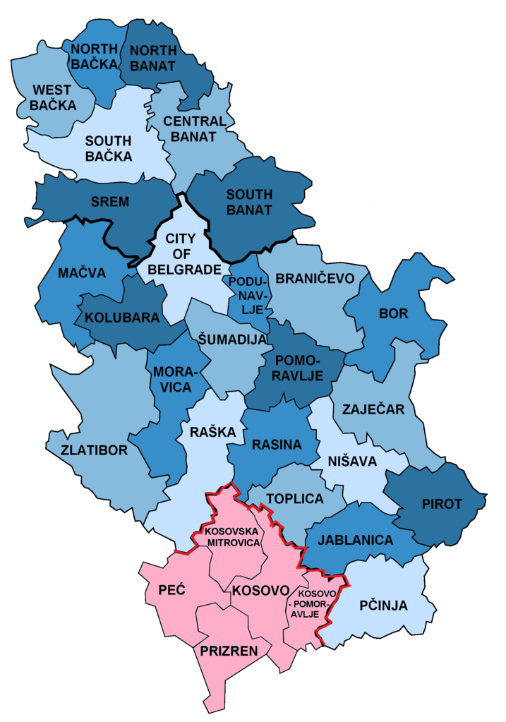
English: This version of the districts of Serbia has been uploaded and represents a consensus of the community to what should be displayed. This presentation does not represent all geopolitical views of the current situation in Kosovo and Serbia, so alternate presentation forms are available as displayed in "เวอร์ชันอื่น". Wikis are able to determine their appropriate usage, it is Commons role to provide those representations.
ความย่อ
คำอธิบายDistricts of Serbia.png
English: Map of districts of Serbia
Српски / srpski: Карта округа Србијe (енглеска верзија)
วันที่
(UTC)
แหล่งที่มา
Disricts_of_Serbia_by_population_density.svg
ผู้สร้างสรรค์
Disricts_of_Serbia_by_population_density.svg: Gajmar at ru.wikipedia
derivative work: Vanjagenije (talk)
เวอร์ชันอื่น
ไฟล์อื่นที่ใช้ไฟล์นี้:
Bor district.png
Borski okrug.PNG
Branicevo district.png
Central Banat district.png
Grad Beograd (city of Belgrade).png
Jablanica district.png
Kolubara district.png
Kosovo district.png
Kosovska Mitrovica district.png
Kosovsko Pomoravlje district.png
Macva district.png
Moravica district.png
Nisava district.png
North Backa district.png
North Banat district.png
Pcinja district.png
Pec distrikt.png
Pirot district.png
Podunavlje district.png
Pomoravlje district.png
Prizren district.png
Rasina district.png
Raska district.png
South Backa district.png
South Banat district.png
Srem district.png
Sumadija district.png
Toplica district.png
West Backa district.png
Zajecar district.png
Zlatibor district.png
Version with disputed Kosovo
Version without Kosovo
Serbian language version
German-language compatible version
การอนุญาตใช้สิทธิ
Public domainPublic domainfalsefalse
บันทึกการอัพโหลด
This image is a derivative work of the following images:
File:Disricts_of_Serbia_by_population_density.svg licensed with PD-self
2010-04-25T18:39:42Z Алексей Глушков 765x1060 (47381 Bytes) {{Information |Description={{en|1=Map of disricts of Serbia by population density}} {{sr|1=Карта округа Србија на густини становништва}} |Source=Own work |Author=Gajmar at [http://ru.wiki
Reverted to version as of 21:27, 31 May 2015 (UTC) Consensus. Showing the disputed status of Kosovo. (Districts in Kosovo are also shown as claimed by serbia) /// Its better to have one single map instead of many different ones. (Adding that the other maps are not in use at all compared to this one)
ไฟล, districts, serbia, ไฟล, ประว, ไฟล, หน, าท, ภาพน, การใช, ไฟล, วนกลาง, อม, ลเก, ยวก, บภาพขนาดของต, วอย, างน, กเซล, ความละเอ, ยดอ, กเซล, กเซล, กเซล, กเซล, กเซล, ภาพท, ความละเอ, ยดส, งกว, 8206, กเซล, ขนาดไฟล, โลไบต, ชน, ดไมม, image, ปภาพหร, อไฟล, เส, ยงน, นฉบ. ifl prawtiifl hnathimiphaphni karichiflswnklang khxmulekiywkbphaphkhnadkhxngtwxyangni 420 599 phikesl khwamlaexiydxun 168 240 phikesl 336 480 phikesl 538 768 phikesl 717 1 024 phikesl 1 824 2 603 phikesl duphaphthimikhwamlaexiydsungkwa 8206 1 824 2 603 phikesl khnadifl 445 kiolibt chnidimm image png rupphaphhruxiflesiyngni tnchbbxyuthi khxmmxns raylaexiyddanlang epnkhxkhwamthiaesdngphlcak ifltnchbbinkhxmmxns khxmmxnsepnewbistinokhrngkarsahrbekbrwbrwmsuxesri thi khunsamarthchwyid The factual accuracy of this map or the file name is disputed Reason English This version of the districts of Serbia has been uploaded and represents a consensus of the community to what should be displayed This presentation does not represent all geopolitical views of the current situation in Kosovo and Serbia so alternate presentation forms are available as displayed in ewxrchnxun Wikis are able to determine their appropriate usage it is Commons role to provide those representations khwamyx khaxthibayDistricts of Serbia png English Map of districts of Serbia Srpski srpski Karta okruga Srbiјe engleska verziјa wnthi 30 knyayn ph s 2553 17 12 UTC aehlngthima Disricts of Serbia by population density svgphusrangsrrkh Disricts of Serbia by population density svg Gajmar at ru wikipedia derivative work Vanjagenije talk ewxrchnxun iflxunthiichiflni Bor district png Borski okrug PNG Branicevo district png Central Banat district png Grad Beograd city of Belgrade png Jablanica district png Kolubara district png Kosovo district png Kosovska Mitrovica district png Kosovsko Pomoravlje district png Macva district png Moravica district png Nisava district png North Backa district png North Banat district png Pcinja district png Pec distrikt png Pirot district png Podunavlje district png Pomoravlje district png Prizren district png Rasina district png Raska district png South Backa district png South Banat district png Srem district png Sumadija district png Toplica district png West Backa district png Zajecar district png Zlatibor district pngVersion with disputed Kosovo Version without Kosovo Serbian language version German language compatible version karxnuyatichsiththi Public domain Public domain false falsekhapheca phuthuxlikhsiththiinnganni khxmxbnganihepnsatharnsmbti prakasnimiphlthwolkinbangpraeths karkrathadngklawxacimsamarththaidtamkdhmaykhaphecaxnuyatihthukkhnmisiththiinkarichiflniinthukehtuphlkarich odyimmimienguxnikh ewnaetkdhmayimxnuyatihthaechnnnbnthukkarxphohld This image is a derivative work of the following images File Disricts of Serbia by population density svg licensed with PD self 2010 04 25T18 39 42Z Aleksej Glushkov 765x1060 47381 Bytes Information Description en 1 Map of disricts of Serbia by population density sr 1 Karta okruga Srbiјa na gustini stanovnishtva Source Own work Author Gajmar at http ru wikiUploaded with derivativeFXkhabrryayodyyxithyephimkhabrryaythrrthdediywephuxkhyaykhwamwaiflnimixairixethmthiaesdngxyuiniflniprakxbdwysthanalikhsiththicopyrighted dedicated to the public domain by copyright holder xngkvssyyaxnuyatreleased into the public domain by the copyright holder xngkvswnthisrang wnkxtng30 knyayn 2010 prawtiifl khlikwnthi ewlaephuxduiflthipraktinkhnann lasud ekasud du ihmkwa 10 ekakwa 10 10 20 50 100 250 500 wnthi ewlarupyxkhnadphuichkhwamehn pccubn15 02 24 kumphaphnth 25651 824 2 603 445 kiolibt TurelioReverted to version as of 11 37 2 October 2021 UTC as violation of COM OW 03 10 15 mkrakhm 25651 824 2 603 589 kiolibt TomasdeAquino2stable version per file name 18 37 2 tulakhm 25641 824 2 603 445 kiolibt InNeed95Reverted to version as of 19 42 29 September 2021 UTC Rv Sock Acc POV Push Vandlism 13 35 30 knyayn 25641 824 2 603 589 kiolibt Aquinasthomes1Reverted to version as of 03 42 26 September 2021 UTC Revert Vandalism 02 42 30 knyayn 25641 824 2 603 445 kiolibt InNeed95Reverted to version as of 13 20 6 August 2021 UTC Rv Sock Acc POV Push 10 42 26 knyayn 25641 824 2 603 589 kiolibt Aquinasthomes1minor fix in contour 09 53 26 knyayn 25641 824 2 603 458 kiolibt Aquinasthomes1Reverted to version as of 22 39 31 May 2015 UTC Per alternative image 20 20 6 singhakhm 25641 824 2 603 445 kiolibt InNeed95Reverted to version as of 21 27 31 May 2015 UTC Consensus Showing the disputed status of Kosovo Districts in Kosovo are also shown as claimed by serbia Its better to have one single map instead of many different ones Adding that the other maps are not in use at all compared to this one 05 39 1 mithunayn 25581 824 2 603 458 kiolibt AnastanWe already have that file File Districts of Serbia Kosovo disputed png 04 27 1 mithunayn 25581 824 2 603 445 kiolibt VS6507consensus version lasud ekasud du ihmkwa 10 ekakwa 10 10 20 50 100 250 500 hnathimiphaphni hnatxipni oyngmathiphaphni praethsesxrebiy karichiflswnklang wikixuntxipniichiflni karichbn bar wikipedia org ISO 3166 2 RS karichbn ca wikipedia org Districtes de Serbia Organitzacio territorial de Serbia karichbn cs wikipedia org Srbsko Administrativni deleni Srbska karichbn el wikipedia org Serbia karichbn en wikipedia org Districts of Serbia Administrative divisions of Serbia karichbn es wikipedia org Distritos de Serbia karichbn fa wikipedia org تقسیمات کشوری صربستان karichbn fi wikipedia org Zajecarin piirikunta Zlatibor karichbn frr wikipedia org ISO 3166 2 RS karichbn fr wikipedia org Districts de Serbie Subdivisions de la Serbie karichbn id wikipedia org Pembagian administratif Serbia karichbn lt wikipedia org Serbijos apygardos karichbn mzn wikipedia org صربستون karichbn or wikipedia org ବ ୟବହ ରକ ର Snip1 List of districts of Serbia karichbn pl wikipedia org Podzial administracyjny Serbii karichbn pnb wikipedia org سربیا دے ضلعے karichbn ps wikipedia org صربیا د صربیا هیواد ایداري وېش karichbn ro wikipedia org Organizarea administrativă a Serbiei karichbn sco wikipedia org Destricts o Serbie karichbn sh wikipedia org Istorija okruga Srbije karichbn tr wikipedia org Sirbistan in idari bolumleri Sirbistan in ilceleri Sirbistan in belediyeleri karichbn ur wikipedia org سربیا کے اضلاع karichbn vec wikipedia org Serbiakhxmulekiywkbphaph phaphnimikhxmulephimetim sungswnihymacakklxngdicitxlhruxsaeknenxrthisamarthekbkhxmuldngklawiwrwmkbphaphid thaphaphnithukprbprungaekikhhruxepliynaeplngcakedim khxmulbangxyangcayngkhngimepliynaeplngehmuxnphaphthithukprbprungaekikhnnkhwamlaexiydaenwnxn37 8 dpckhwamlaexiydaenwtng37 8 dpcaekikhphaphlasud18 44 25 emsayn 2553 ekhathungcak https th wikipedia org wiki ifl Districts of Serbia png, wikipedia, วิกิ หนังสือ, หนังสือ, ห้องสมุด,