Alemannisch ∙ Bahasa Indonesia ∙ Bahasa Melayu ∙ British English ∙ català ∙ čeština ∙ dansk ∙ Deutsch ∙ eesti ∙ English ∙ español ∙ Esperanto ∙ euskara ∙ français ∙ Frysk ∙ galego ∙ hrvatski ∙ Ido ∙ italiano ∙ lietuvių ∙ magyar ∙ Nederlands ∙ norsk bokmål ∙ norsk nynorsk ∙ occitan ∙ Plattdüütsch ∙ polski ∙ português ∙ português do Brasil ∙ română ∙ Scots ∙ sicilianu ∙ slovenčina ∙ slovenščina ∙ suomi ∙ svenska ∙ Tiếng Việt ∙ Türkçe ∙ vèneto ∙ Ελληνικά ∙ беларуская (тарашкевіца) ∙ български ∙ македонски ∙ нохчийн ∙ русский ∙ српски / srpski ∙ татарча/tatarça ∙ українська ∙ ქართული ∙ հայերեն ∙ বাংলা ∙ தமிழ் ∙ മലയാളം ∙ ไทย ∙ 한국어 ∙ 日本語 ∙ 简体中文 ∙ 繁體中文 ∙ עברית ∙ العربية ∙ فارسی ∙ +/−
ความย่อ
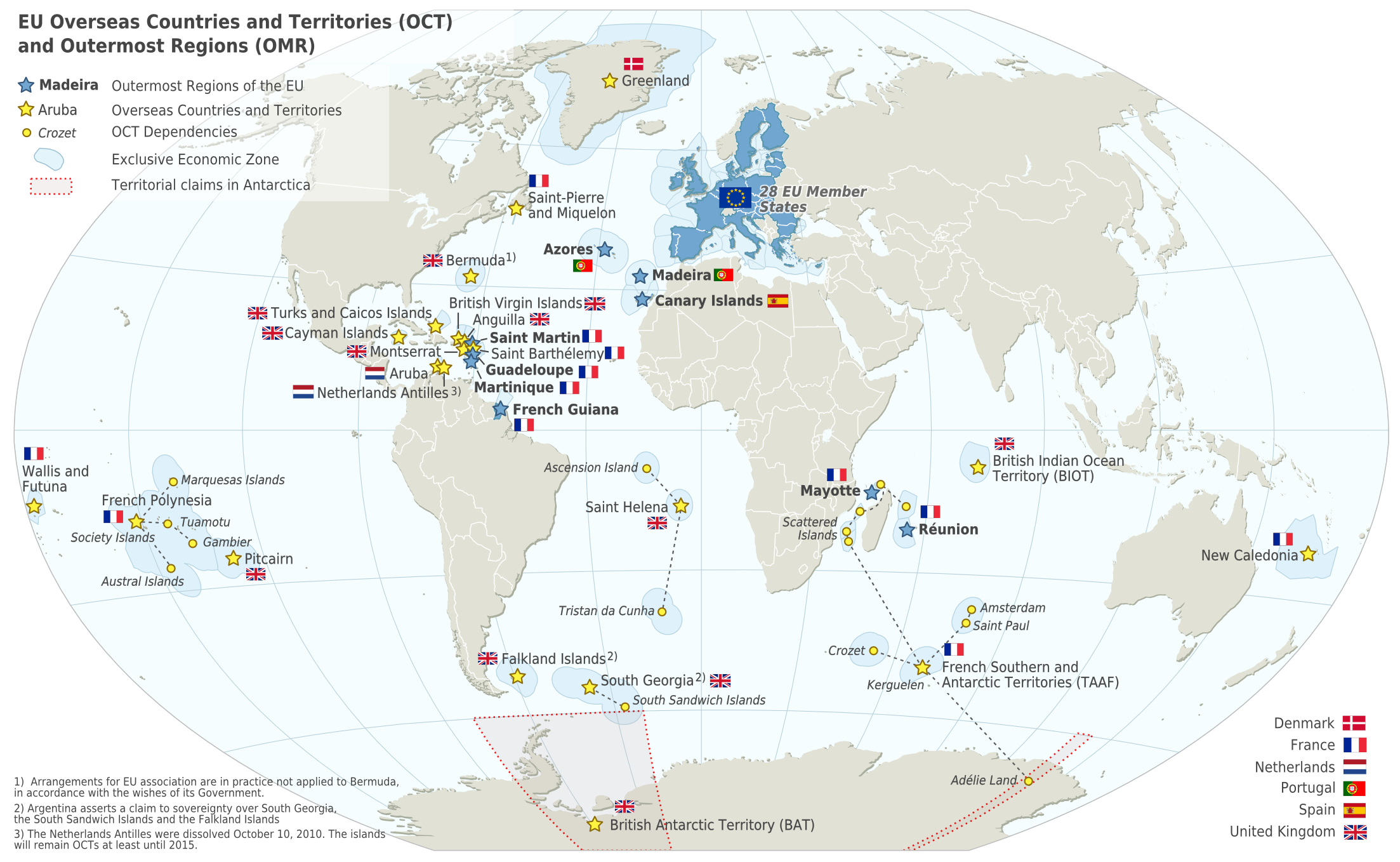
คำอธิบายEU OCT and OMR map en.png
Deutsch: Karte der EU – Überseeische Länder und Hoheitsgebiete (OCT) und die Gebiete in äußerster Randlage (OMR). Diese Karte zeigt den räumlichen Geltungsbereich der Verträge der EU gemäß Artikel 52 des Vertrags über die Europäische Union und Artikel 355 des Vertrags über die Arbeitsweise der Europäischen Union.
Français : Carte de l’Union Européenne, en particulier les Pays et territoires d’outre-mer et les Régions ultrapériphériques. Cette carte montre la portée d’action territoriale des Traités de l’UE comme spécifié par l’Article 52 du Traité sur l’Union Européenne et l’Article 355 du Traité sur le Fonctionnement de l’Union Européenne.
English: Map of the EU – Overseas Countries and Territories (OCT) and Outermost Regions (OMR). This map shows the territorial scope of the Treaties of the EU as specified by Article 52 of the Treaty on European Union and Article 355 of the Treaty on the Functioning of the European Union.
azərbaycanca ∙ čeština ∙ Deutsch ∙ Deutsch (Sie-Form) ∙ English ∙ español ∙ français ∙ italiano ∙ latviešu ∙ magyar ∙ Nederlands ∙ Plattdüütsch ∙ polski ∙ português ∙ română ∙ sicilianu ∙ slovenščina ∙ suomi ∙ македонски ∙ русский ∙ ქართული ∙ հայերեն ∙ বাংলা ∙ ไทย ∙ +/−
Reverted to version as of 14:48, 27 February 2019 (UTC) – The image includes UK territories, and was made prior to Brexit; please keep the UK in the map as part of the European Union for this reason
ไฟล, ไฟล, ประว, ไฟล, หน, าท, ภาพน, การใช, ไฟล, ามโครงการ, อม, ลเก, ยวก, บภาพขนาดของต, วอย, างน, กเซล, ความละเอ, ยดอ, กเซล, กเซล, กเซล, กเซล, กเซล, ภาพท, ความละเอ, ยดส, งกว, 8206, กเซล, ขนาดไฟล, โลไบต, ชน, ดไมม, image, ปภาพหร, อไฟล, เส, ยงน, นฉบ, บอย, คอมมอนส, . ifl prawtiifl hnathimiphaphni karichiflkhamokhrngkar khxmulekiywkbphaphkhnadkhxngtwxyangni 800 492 phikesl khwamlaexiydxun 320 197 phikesl 640 394 phikesl 1 024 630 phikesl 1 280 788 phikesl 2 206 1 358 phikesl duphaphthimikhwamlaexiydsungkwa 8206 2 206 1 358 phikesl khnadifl 1 003 kiolibt chnidimm image png rupphaphhruxiflesiyngni tnchbbxyuthi khxmmxns raylaexiyddanlang epnkhxkhwamthiaesdngphlcak ifltnchbbinkhxmmxns khxmmxnsepnewbistinokhrngkarsahrbekbrwbrwmsuxesri thi khunsamarthchwyid phaphnimiphaphinrupaebbewketxr SVG hakphaph SVG thaihkaraesdngphldikwa hnathiichphaphnikhwrepliynipichphaph SVG aethn File EU OCT and OMR map en png File Special member state territories and the European Union svg sahrbkhxmulephimetimekiywkbphaphewketxr duthi karepliynipichphaph SVG inkhxmmxnsnxkcaknisamarthduephimetimekiywkb khxmulekiywkbkarrxngrbphaph SVG sahrbsxftaewrmiediywiki id inphasaxun Alemannisch nbsp Bahasa Indonesia nbsp Bahasa Melayu nbsp British English nbsp catala nbsp cestina nbsp dansk nbsp Deutsch nbsp eesti nbsp English nbsp espanol nbsp Esperanto nbsp euskara nbsp francais nbsp Frysk nbsp galego nbsp hrvatski nbsp Ido nbsp italiano nbsp lietuviu nbsp magyar nbsp Nederlands nbsp norsk bokmal nbsp norsk nynorsk nbsp occitan nbsp Plattduutsch nbsp polski nbsp portugues nbsp portugues do Brasil nbsp romană nbsp Scots nbsp sicilianu nbsp slovencina nbsp slovenscina nbsp suomi nbsp svenska nbsp Tiếng Việt nbsp Turkce nbsp veneto nbsp Ellhnika nbsp belaruskaya tarashkevica nbsp blgarski nbsp makedonski nbsp nohchijn nbsp russkij nbsp srpski srpski nbsp tatarcha tatarca nbsp ukrayinska nbsp ქართული nbsp հայերեն nbsp ব ল nbsp தம ழ nbsp മലയ ള nbsp ithy nbsp 한국어 nbsp 日本語 nbsp 简体中文 nbsp 繁體中文 nbsp עברית nbsp العربية nbsp فارسی nbsp nbsp khwamyx khaxthibayEU OCT and OMR map en png Deutsch Karte der EU Uberseeische Lander und Hoheitsgebiete OCT und die Gebiete in ausserster Randlage OMR Diese Karte zeigt den raumlichen Geltungsbereich der Vertrage der EU gemass Artikel 52 des Vertrags uber die Europaische Union und Artikel 355 des Vertrags uber die Arbeits weise der Europaischen Union Francais nbsp Carte de l Union Europeenne en particulier les Pays et territoires d outre mer et les Regions ultraperipheriques Cette carte montre la portee d action territoriale des Traites de l UE comme specifie par l Article 52 du Traite sur l Union Europeenne et l Article 355 du Traite sur le Fonctionnement de l Union Europeenne English Map of the EU Overseas Countries and Territories OCT and Outermost Regions OMR This map shows the territorial scope of the Treaties of the EU as specified by Article 52 of the Treaty on European Union and Article 355 of the Treaty on the Functioning of the European Union wnthi 2 phvscikayn ph s 2547 aehlngthima Natural Earth 1 50m http www naturalearthdata com phusrangsrrkh Alexrk2 ewxrchnxun ar Arabic version النسخة العربية de German version deutsche Version fr French version version francais EU OCT and OMR map png aephnthinithuksranghruxphthnakhuncak Kartenwerkstatt hxngptibtikaraephnthi khxngwikiphiediyphasaeyxrmn sungkhunsamarthesnxaephnthiephuxphthnaidechnediywkn azerbaycanca nbsp cestina nbsp Deutsch nbsp Deutsch Sie Form nbsp English nbsp espanol nbsp francais nbsp italiano nbsp latviesu nbsp magyar nbsp Nederlands nbsp Plattduutsch nbsp polski nbsp portugues nbsp romană nbsp sicilianu nbsp slovenscina nbsp suomi nbsp makedonski nbsp russkij nbsp ქართული nbsp հայերեն nbsp ব ল nbsp ithy nbsp nbsp iflkrafiksni srangkhunodyich nbsp GeoTools nbsp iflPNG phaphkrafiksewketxrni srangkhunodyich nbsp Inkscape karxnuyatichsiththi khapheca inthanaphuthuxlikhsiththikhxngphaphhruxsuxni xnuyatihichphaphhruxsuxniphayitenguxnikhtxipni iflnixyuphayitsyyaxnuyat khriexthifkhxmmxns aebbaesdngthima xnuyataebbediywkn 3 0 tnchbbkhunsamarth thicaaebngpn thicathasaena aeckcay aelasngngandngklawtxip thicaeriyberiyngihm thicaddaeplngngandngklaw phayitenguxnikhtxipni aesdngthima khuntxngihekiyrtiecakhxngnganxyangehmaasm odyephimlingkipyngsyyaxnuyat aelarabuhakmikarepliynaeplng khunxacthaechnniidinrupaebbidkidtamkhwr aettxngimichinlksnathiaenawaphuihxnuyatsnbsnunkhunhruxkarichngankhxngkhun xnuyataebbediywkn hakkhunddaeplng epliynrup hruxtxetimnganni khuntxngichsyyaxnuyataebbediywknhruxaebbthiehmuxnkbsyyaxnuyatthiichkbnganniethannhttps creativecommons org licenses by sa 3 0 CC BY SA 3 0 Creative Commons Attribution Share Alike 3 0 true truekhabrryayodyyxithyephimkhabrryaythrrthdediywephuxkhyaykhwamwaiflnimixairxngkvsEuropean Union territories prior to BrexitixethmthiaesdngxyuiniflniprakxbdwysthanalikhsiththimilikhsiththisyyaxnuyatCreative Commons Attribution ShareAlike 3 0 Unported nbsp xngkvswnthisrang wnkxtngemsayn 2011media type nbsp xngkvsimage png prawtiifl khlikwnthi ewlaephuxduiflthipraktinkhnann lasud ekasud du ihmkwa 10 ekakwa 10 10 20 50 100 250 500 wnthi ewlarupyxkhnadphuichkhwamehn pccubn13 14 18 kumphaphnth 25672 206 1 358 1 003 kiolibt Sqrt of 2Reverted to version as of 18 05 12 June 2023 UTC 23 08 15 mkrakhm 25672 206 1 358 954 kiolibt MultituberculataReverted to version as of 08 53 31 May 2023 UTC 01 05 13 mithunayn 25662 206 1 358 1 003 kiolibt DecafPotatoReverted to version as of 14 48 27 February 2019 UTC The image includes UK territories and was made prior to Brexit please keep the UK in the map as part of the European Union for this reason 15 53 31 phvsphakhm 25662 206 1 358 954 kiolibt IktsokhNote 03 01 22 phvsphakhm 25662 206 1 358 951 kiolibt IktsokhCorrection 16 56 18 phvsphakhm 25662 206 1 358 950 kiolibt IktsokhUpdated 21 48 27 kumphaphnth 25622 206 1 358 1 003 kiolibt Radom1967Reverted to version as of 17 02 22 March 2018 UTC No need 19 13 25 kumphaphnth 25622 206 1 358 999 kiolibt OdemirenseCountries with overseas regions in dark blue 00 02 23 minakhm 25612 206 1 358 1 003 kiolibt MaphobbyistSouth Sudan border 01 24 2 mkrakhm 25572 206 1 358 1 emkaibt Alexrk2From 1 January 2014 the status of Mayotte will be that of an outermost region COUNCIL DIRECTIVE 2013 61 EU of 17 December 2013 lasud ekasud du ihmkwa 10 ekakwa 10 10 20 50 100 250 500 hnathimiphaphni hnatxipni oyngmathiphaphni aekhribebiynenethxraelnd karichiflkhamokhrngkar wikixuntxipniichiflni karichbn an wikipedia org Usuario HN Netherlands Antilles AN karichbn ar wikipedia org أقاليم ذات عضوية خاصة في الاتحاد الأوروبي تاريخ الاستعمار karichbn ast wikipedia org Territorios especiales de la Xunion Europea karichbn azb wikipedia org هولند آنتیل آدالاری karichbn bn wikipedia org ইউর প য ইউন য ন ক ন র দ ব পপ ঞ জ karichbn ca wikipedia org Groenlandia Aruba Territoris especials de la Unio Europea karichbn cs wikipedia org Gronsko Evropska unie karichbn en wikipedia org Aruba Canary Islands Greenland Guadeloupe Martinique Mayotte Madeira Netherlands Antilles Reunion Overseas departments and regions of France Decolonisation of Africa History of colonialism Sint Maarten French Guiana User Kazkaskazkasako Books All Caribbean Netherlands User Tom29739 The EU User Abyssal bla User Falcaorib List of colonies karichbn en wikiquote org Colonialism karichbn en wikivoyage org European Union karichbn es wikipedia org Usuario Allanloji Relaciones India Union Europea Relaciones India Union Europea karichbn fa wikipedia org قلمرو وابسته karichbn fi wikipedia org Euroopan unionin jasenvaltioiden erityisalueet Alankomaiden Karibia karichbn gl wikipedia org Antillas Neerlandesas Sint Maarten Paises Baixos Caribenos Territorios especiais da Union Europea karichbn id wikipedia org Madeira Reunion karichbn ilo wikipedia org Portugal karichbn it wikipedia org Bermuda karichbn ka wikipedia org აფრიკის დეკოლონიზაცია karichbn mk wikipedia org Prekumorski departmani i regioni na Franciјa karichbn nds nl wikipedia org Reunion dukarichkhamokhrngkarephimetimkhxngiflnikhxmulekiywkbphaph phaphnimikhxmulephimetim sungswnihymacakklxngdicitxlhruxsaeknenxrthisamarthekbkhxmuldngklawiwrwmkbphaphid thaphaphnithukprbprungaekikhhruxepliynaeplngcakedim khxmulbangxyangcayngkhngimepliynaeplngehmuxnphaphthithukprbprungaekikhnnkhwamlaexiydaenwnxn37 8 dpckhwamlaexiydaenwtng37 8 dpcsxftaewrthiichwww inkscape org ekhathungcak https th wikipedia org wiki ifl EU OCT and OMR map en png, wikipedia, วิกิ หนังสือ, หนังสือ, ห้องสมุด,