ภาพแผนที่นี้ ควรจะถูกสร้างใหม่เป็นกราฟิกส์เวกเตอร์ ซึ่งมีข้อดีอีกหลายประการ ดูเพิ่มเติมที่คอมมอนส์:สื่อต้องการเก็บกวาดสำหรับสารสนเทศเพิ่มเติม หากภาพนี้มีในรูปแบบกราฟิกส์เวกเตอร์อยู่แล้ว กรุณาอัปโหลดและแทนที่แม่แบบนี้ด้วย {{vector version available|ชื่อภาพใหม่}} แนะนำเป็นอย่างยิ่งให้ตั้งชื่อไฟล์เวกเตอร์ใหม่นั้นในรูปแบบ "East China Sea Map.svg" แล้วใส่แม่แบบ Vector version available (หรือ Vva) ซึ่งไม่ต้องใช้พารามิเตอร์ ชื่อภาพใหม่
This map image was uploaded in the JPEG format even though it consists of non-photographic data. This information could be stored more efficiently or accurately in the PNG or SVG format. If possible, please upload a PNG or SVG version of this image without compression artifacts, derived from a non-JPEG source (or with existing artifacts removed). After doing so, please tag the JPEG version with {{Superseded|NewImage.ext}} and remove this tag. This tag should not be applied to photographs or scans. If this image is a diagram or other image suitable for vectorisation, please tag this image with {{Convert to SVG}} instead of {{BadJPEG}}. If not suitable for vectorisation, use {{Convert to PNG}}. For more information, see {{BadJPEG}}.
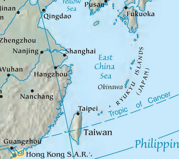
Map of the East China Sea. Mapa Východočínského moře (popisky v angličtině). Source: tr:Resim:DoğuÇinDenizi.jpg Licence: public domain, because it originally comes from the CIA World Factbook, i.e. from a United States federal governemental agency.
Map of the East China Sea. Mapa Východočínského moře (popisky v angličtině). Source: tr:Resim:DoğuÇinDenizi.jpg Licence: public domain, because it originally comes from the CIA World Factbook, i.e. from a United States federal governemental
ไฟล, east, china, ไฟล, ประว, ไฟล, หน, าท, ภาพน, การใช, ไฟล, วนกลาง, อม, ลเก, ยวก, บภาพไม, ภาพท, รายละเอ, ยดส, งกว, าน, east, china, 8206, กเซล, ขนาดไฟล, โลไบต, ชน, ดไมม, image, jpeg, ปภาพหร, อไฟล, เส, ยงน, นฉบ, บอย, คอมมอนส, รายละเอ, ยดด, านล, าง, เป, นข, อควา. ifl prawtiifl hnathimiphaphni karichiflswnklang khxmulekiywkbphaphimmiphaphthimiraylaexiydsungkwani East China Sea Map jpg 8206 600 533 phikesl khnadifl 88 kiolibt chnidimm image jpeg rupphaphhruxiflesiyngni tnchbbxyuthi khxmmxns raylaexiyddanlang epnkhxkhwamthiaesdngphlcak ifltnchbbinkhxmmxns khxmmxnsepnewbistinokhrngkarsahrbekbrwbrwmsuxesri thi khunsamarthchwyid phaphaephnthini khwrcathuksrangihmepnkrafiksewketxr sungmikhxdixikhlayprakar duephimetimthikhxmmxns suxtxngkarekbkwadsahrbsarsnethsephimetim hakphaphnimiinrupaebbkrafiksewketxrxyuaelw krunaxpohldaelaaethnthiaemaebbnidwy vector version available i chuxphaphihm i aenanaepnxyangyingihtngchuxiflewketxrihmnninrupaebb East China Sea Map svg aelwisaemaebb Vector version available hrux Vva sungimtxngichpharamietxr chuxphaphihm This map image was uploaded in the JPEG format even though it consists of non photographic data This information could be stored more efficiently or accurately in the PNG or SVG format If possible please upload a PNG or SVG version of this image without compression artifacts derived from a non JPEG source or with existing artifacts removed After doing so please tag the JPEG version with Superseded NewImage ext and remove this tag This tag should not be applied to photographs or scans If this image is a diagram or other image suitable for vectorisation please tag this image with Convert to SVG instead of BadJPEG If not suitable for vectorisation use Convert to PNG For more information see BadJPEG Map of the East China Sea Mapa Vychodocinskeho more popisky v anglictine Source tr Resim DoguCinDenizi jpg Licence public domain because it originally comes from the CIA World Factbook i e from a United States federal governemental agency Public domain Public domain false false nbsp nganniidthukephyaephrsusatharnsmbtiodyecakhxng Danbury cakwikiphiediy sungmiphlthwolk inkrnithikdhmayimxnuyatihthaechnnn Danbury xnuyatihthukkhnmisiththiinkarichiflniinthukehtuphlkarich odyimmimienguxnikh ewnaetkdhmayimxnuyatihthaechnnnkhabrryayodyyxithyephimkhabrryaythrrthdediywephuxkhyaykhwamwaiflnimixairxahrbبحر الصين الشرقيixethmthiaesdngxyuiniflniprakxbdwysthanalikhsiththicopyrighted dedicated to the public domain by copyright holder nbsp xngkvssyyaxnuyatreleased into the public domain by the copyright holder nbsp xngkvs prawtiifl khlikwnthi ewlaephuxduiflthipraktinkhnann wnthi ewlarupyxkhnadphuichkhwamehn pccubn20 26 13 mithunayn 2550600 533 88 kiolibt ZemanMap of the East China Sea Mapa Vychodocinskeho more popisky v anglictine Source tr Resim DoguCinDenizi jpg Licence public domain because it originally comes from the CIA World Factbook i e from a United States federal governemental hnathimiphaphni hnatxipni oyngmathiphaphni cnghwdoxkinawa thaelcintawnxxk karichiflswnklang wikixuntxipniichiflni karichbn ar wikipedia org بحر الصين الشرقي karichbn arz wikipedia org بحر الصين الشرقى karichbn bcl wikipedia org Prepektura kan Okinawa karichbn be wikipedia org Ushodne Kitajskae mora karichbn bn wikipedia org প র ব চ ন স গর karichbn cdo wikipedia org Dĕ ng Dṳ ng guok Hai karichbn cs wikipedia org Rjukju Fernao Pires de Andrade karichbn el wikipedia org 8alassa ths Anatolikhs Kinas karichbn en wikipedia org Fernao Pires de Andrade Ocean fisheries karichbn eo wikipedia org Rjukju insularo karichbn es wikipedia org Islas Ryukyu Islas Sakishima Fernao Pires de Andrade karichbn eu wikipedia org Okinawa uhartea Ekialdeko Txinako itsasoa Okinawa prefektura karichbn fa wikipedia org استان اوکیناوا دریای چین شرقی تاریخ جزایر ریوکیو karichbn fy wikipedia org Eastsineeske See Giele See karichbn gl wikipedia org Mar da China Oriental karichbn he wikipedia org אוקינאווה מחוז karichbn hr wikipedia org Kina karichbn hy wikipedia org Օկինավա karichbn id wikipedia org Prefektur Okinawa Kepulauan Yaeyama karichbn ilo wikipedia org Prepektura ti Okinawa karichbn incubator wikimedia org Wp mnc lio kio adun tun karichbn is wikipedia org Austur Kinahaf karichbn it wikipedia org Ryukyu karichbn ja wikipedia org フェルナン ピレス デ アンドラーデ karichbn jv wikipedia org Prefektur Okinawa karichbn kk wikipedia org Shygys Қytaj tenizi karichbn ko wikipedia org 오키나와현 류큐 제도 karichbn lt wikipedia org Rytu Kinijos jura Jonagunis karichbn mk wikipedia org Okeanski ribnik karichbn ml wikipedia org ക ഴക കൻ ച ന ക കടൽ karichbn ms wikipedia org Laut China Timur Kepulauan Ryukyu karichbn no wikipedia org Ost Kina havet karichbn pa wikipedia org ਪ ਰਬ ਚ ਨ ਸਮ ਦਰ karichbn pl wiktionary org Morze Wschodniochinskie Ushodne Kitajskae mora karichbn pt wikipedia org Okinawa Kallima dukarichthwolkephimetimkhxngiflnikhxmulekiywkbphaph phaphnimikhxmulephimetim sungswnihymacakklxngdicitxlhruxsaeknenxrthisamarthekbkhxmuldngklawiwrwmkbphaphid thaphaphnithukprbprungaekikhhruxepliynaeplngcakedim khxmulbangxyangcayngkhngimepliynaeplngehmuxnphaphthithukprbprungaekikhnnkarcdwangphaphpktikhwamlaexiydaenwnxn300 dpikhwamlaexiydaenwtng300 dpisxftaewrthiichACD Systems Digital Imagingaekikhphaphlasud22 36 1 phvsphakhm 2548taaehnng Y aela Ckungklangrunexksif Exif 2 2esiywwinathi wnthi ewla73 ekhathungcak https th wikipedia org wiki ifl East China Sea Map jpg, wikipedia, วิกิ หนังสือ, หนังสือ, ห้องสมุด,