The factual accuracy of this map or the file name is disputed.
Reason: Current US Territory of New France needs correction (it clashes with the Thirteen colonies and New Spain). For correct guidance see:
The factual accuracy of this map or the file name is disputed.
Reason: Map uses inaccurately Haiti's current border when it is approx. 6,000 km² bigger today than when she gained her independence from France.
The factual accuracy of this map or the file name is disputed.
Reason: It is inaccurate to show the Dutch colonies (Suriname and South Africa) as having been part of the French Colony, Suriname was occupied by the British from 1804 to 1816, and The Cape Colony from 1806.
ภาพแผนที่ทางประวัติศาสตร์นี้ ควรจะถูกสร้างใหม่เป็นกราฟิกส์เวกเตอร์ ซึ่งมีข้อดีอีกหลายประการ ดูเพิ่มเติมที่คอมมอนส์:สื่อต้องการเก็บกวาดสำหรับสารสนเทศเพิ่มเติม หากภาพนี้มีในรูปแบบกราฟิกส์เวกเตอร์อยู่แล้ว กรุณาอัปโหลดและแทนที่แม่แบบนี้ด้วย {{vector version available|ชื่อภาพใหม่}} แนะนำเป็นอย่างยิ่งให้ตั้งชื่อไฟล์เวกเตอร์ใหม่นั้นในรูปแบบ "EmpireFrench.svg" แล้วใส่แม่แบบ Vector version available (หรือ Vva) ซึ่งไม่ต้องใช้พารามิเตอร์ ชื่อภาพใหม่
added territory in india and america, source : https://commons.wikimedia.org/wiki/File:New_France_(orthographic_projection).svg https://commons.wikimedia.org/wiki/File:French_possessions_in_the_Americas_(1534-1803).png https://commons.wikimedia.org/wiki/File:Evolution_empire.png
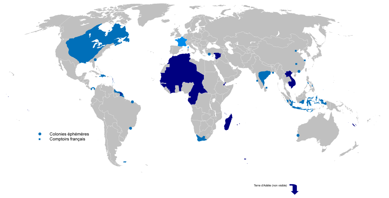
{{Information |Description={{fr|1=Carte de l'Empire Colonial Français de 1542 à 1980 }} |Source={{own}} |Author=Gd21091993 |Date=01/06/2010 |Permission= |other_versions= }}
ไฟล, empirefrench, ไฟล, ประว, ไฟล, หน, าท, ภาพน, การใช, ไฟล, วนกลาง, อม, ลเก, ยวก, บภาพขนาดของต, วอย, างน, กเซล, ความละเอ, ยดอ, กเซล, กเซล, กเซล, กเซล, กเซล, ภาพท, ความละเอ, ยดส, งกว, 8206, กเซล, ขนาดไฟล, โลไบต, ชน, ดไมม, image, ปภาพหร, อไฟล, เส, ยงน, นฉบ, บอย. ifl prawtiifl hnathimiphaphni karichiflswnklang khxmulekiywkbphaphkhnadkhxngtwxyangni 800 407 phikesl khwamlaexiydxun 320 163 phikesl 640 325 phikesl 1 024 521 phikesl 1 280 651 phikesl 2 753 1 400 phikesl duphaphthimikhwamlaexiydsungkwa 8206 2 753 1 400 phikesl khnadifl 193 kiolibt chnidimm image png rupphaphhruxiflesiyngni tnchbbxyuthi khxmmxns raylaexiyddanlang epnkhxkhwamthiaesdngphlcak ifltnchbbinkhxmmxns khxmmxnsepnewbistinokhrngkarsahrbekbrwbrwmsuxesri thi khunsamarthchwyid The factual accuracy of this map or the file name is disputed Reason Current US Territory of New France needs correction it clashes with the Thirteen colonies and New Spain For correct guidance see The factual accuracy of this map or the file name is disputed Reason Map uses inaccurately Haiti s current border when it is approx 6 000 km bigger today than when she gained her independence from France The factual accuracy of this map or the file name is disputed Reason It is inaccurate to show the Dutch colonies Suriname and South Africa as having been part of the French Colony Suriname was occupied by the British from 1804 to 1816 and The Cape Colony from 1806 phaphaephnthithangprawtisastrni khwrcathuksrangihmepnkrafiksewketxr sungmikhxdixikhlayprakar duephimetimthikhxmmxns suxtxngkarekbkwadsahrbsarsnethsephimetim hakphaphnimiinrupaebbkrafiksewketxrxyuaelw krunaxpohldaelaaethnthiaemaebbnidwy vector version available i chuxphaphihm i aenanaepnxyangyingihtngchuxiflewketxrihmnninrupaebb EmpireFrench svg aelwisaemaebb Vector version available hrux Vva sungimtxngichpharamietxr chuxphaphihmkhwamyx khaxthibayEmpireFrench png English Colonial empire from 1542 to 1980 Dark Blue Second colonial empire Light Blue First colonial empirewnthi 01 06 2010aehlngthima ngankhxngtwphusrangsrrkh Gd21091993 karxnuyatichsiththi Public domain Public domain false falsekhapheca phuthuxlikhsiththiinnganni khxmxbnganihepnsatharnsmbti prakasnimiphlthwolkinbangpraeths karkrathadngklawxacimsamarththaidtamkdhmaykhaphecaxnuyatihthukkhnmisiththiinkarichiflniinthukehtuphlkarich odyimmimienguxnikh ewnaetkdhmayimxnuyatihthaechnnnkhabrryayodyyxithyephimkhabrryaythrrthdediywephuxkhyaykhwamwaiflnimixairxngkvsFrench colonial empires from 1542 to 1980 Light blue First colonial empire Dark blue Second colonial empire sepnImperio colonial frances de 1542 a 1980 Azul claro primer imperio colonial Azul oscuro segundo imperio colonial frngessEmpire colonial francais de 1542 a 1980 Bleu clair premier empire colonial Bleu fonce second empire colonialixethmthiaesdngxyuiniflniprakxbdwyphusrangbangkhathiimmiixethmwikisnethschuxphusrangsrrkh Gd21091993chuxphuichwikimiediy Gd21091993yuxaraexl https commons wikimedia org wiki user Gd21091993sthanalikhsiththicopyrighted dedicated to the public domain by copyright holder xngkvssyyaxnuyatreleased into the public domain by the copyright holder xngkvsthimakhxngiflkarsrangdngedimodyphuxpohldMIME type xngkvsimage png prawtiifl khlikwnthi ewlaephuxduiflthipraktinkhnann wnthi ewlarupyxkhnadphuichkhwamehn pccubn00 02 5 emsayn 25652 753 1 400 193 kiolibt Oort kuipertadded territory in india and america source https commons wikimedia org wiki File New France orthographic projection svg https commons wikimedia org wiki File French possessions in the Americas 1534 1803 png https commons wikimedia org wiki File Evolution empire png 22 41 30 minakhm 25652 753 1 400 194 kiolibt Oort kuipertadded colonies under Napoleon I according to https upload wikimedia org wikipedia commons 3 33 French Empire on World 1812 png 19 01 8 tulakhm 25602 753 1 400 116 kiolibt SUM1Fixes unshaded Spanish Morocco Cape Juby Equatorial Guinea Nigeria Southern Cameroons Zanzibar Czech border 20 46 2 minakhm 25592 753 1 400 99 kiolibt Frans45in New Caledonia archipelago only the big island was marked I added iles Loayutes ile de Pins iles Chesterfield 22 29 1 mithunayn 25532 753 1 400 316 kiolibt Gd21091993 Information Description fr 1 Carte de l 039 Empire Colonial Francais de 1542 a 1980 Source own Author Gd21091993 Date 01 06 2010 Permission other versions hnathimiphaphni hnatxipni oyngmathiphaphni ckrwrrdixananikhmfrngess karichiflswnklang wikixuntxipniichiflni karichbn ar wikipedia org الإمبراطورية الاستعمارية الفرنسية قائمة المستعمرات الفرنسية karichbn ast wikipedia org Imperiu colonial frances karichbn azb wikipedia org فرانسه سؤمورگه ایمپراتورلوغو karichbn bg wikipedia org Frenska kolonialna imperiya karichbn br wikipedia org Impalaeriezh trevadennel Frans karichbn ca wikipedia org Imperi colonial frances karichbn cs wikipedia org Rise Francouzska kolonialni rise karichbn el wikipedia org Deyterh gallikh apoikiakh aytokratoria karichbn en wikipedia org User Dimadick Decolonization Kingdom of France Colonial empire Evolution of the French Empire User Jethwarp List of French possessions and colonies Timeline of European imperialism List of modern great powers User Jethwarp UBX French Colonial empire Category Wikipedians interested in European colonial empires Liberation of France Honor killings by region karichbn en wikibooks org World History Maps karichbn en wikiquote org French Colonial Empire karichbn en wiktionary org User Aearthrise RomanceLanguage Creole French Course karichbn eo wikipedia org Imperiismo Franca kolonia imperio Berlina Konferenco karichbn es wikipedia org Imperio colonial frances Anexo Paises donde el frances es idioma oficial Anexo Colonias y protectorados franceses karichbn eu wikipedia org Frantziar Inperio Koloniala karichbn fa wikipedia org امپراتوری استعماری فرانسه فهرست بزرگ ترین امپراتوری های جهان karichbn fi wikipedia org Ranskan siirtomaat karichbn fr wikipedia org Liste des colonies francaises Empire colonial Discussion Empire colonial francais Second empire colonial francais Liste des pays ayant le francais pour langue officielle Colonisation Histoire des grandes puissances Vieilles colonies Wikipedia Oracle semaine 20 2015 Utilisateur Exp JC Brouillon karichbn fr wiktionary org Empire francais karichbn gl wikipedia org Imperio colonial frances karichbn id wikipedia org Imperium kolonial Prancis pertama karichbn it wikipedia org Impero coloniale francese dukarichthwolkephimetimkhxngiflnikhxmulekiywkbphaph phaphnimikhxmulephimetim sungswnihymacakklxngdicitxlhruxsaeknenxrthisamarthekbkhxmuldngklawiwrwmkbphaphid thaphaphnithukprbprungaekikhhruxepliynaeplngcakedim khxmulbangxyangcayngkhngimepliynaeplngehmuxnphaphthithukprbprungaekikhnnsepssiimidprbethiybkhwamkwangkhxngphaph2 753 phikeslkhwamsungkhxngphaph1 400 phikeslkhwamlaexiydaenwnxn72 dpikhwamlaexiydaenwtng72 dpiID echphaakhxngexksartnchbbxmp did bf4cdb69 e5aa 4a4a ab67 9a506eb84f4csxftaewrthiichPixelmator Pro 2 3 8aekikhphaphlasud13 01 8 tulakhm 2560ewlathiaeplngepndicithl12 26 8 tulakhm 2560wnthiaekikhkhxmulemtalasud20 59 4 emsayn 2565 ekhathungcak https th wikipedia org wiki ifl EmpireFrench png, wikipedia, วิกิ หนังสือ, หนังสือ, ห้องสมุด,