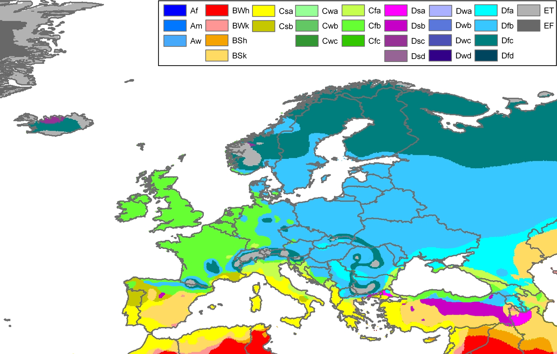
Peel, M. C. and Finlayson, B. L. and McMahon, T. A. (2007). "Updated world map of the Köppen-Geiger climate classification". Hydrol. Earth Syst. Sci.11: 1633-1644. ISSN 1027-5606.
Climate map of Europe (from the "Updated world map of the Köppen-Geiger climate classification").
วันที่
แหล่งที่มา
Hydrology and Earth System Sciences: "Updated world map of the Köppen-Geiger climate classification" (Supplement) - Original file was a JPG-file, this file is has been converted to a PNG-file, without extra modifications, by me (Jeroen).
ผู้สร้างสรรค์
Peel, M. C., Finlayson, B. L., and McMahon, T. A. (University of Melbourne)
Painted the Caspian Sea as white as it should have been, because the Köppen system is based on the concept that climate types are correlated with the natural vegetation. Thus with Köppen, climate zone boundaries have been selected with vegetation distri
Citation: '''Peel, M. C., Finlayson, B. L., and McMahon, T. A.: Updated world map of the Köppen-Geiger climate classification, Hydrol. Earth Syst. Sci., 11, 1633-1644, 2007.''' {{Information |Description= Climate map of Europe (from the "[[:Image:Worl
ไฟล, europe, köppen, ไฟล, ประว, ไฟล, หน, าท, ภาพน, การใช, ไฟล, วนกลาง, อม, ลเก, ยวก, บภาพขนาดของต, วอย, างน, กเซล, ความละเอ, ยดอ, กเซล, กเซล, กเซล, กเซล, กเซล, ภาพท, ความละเอ, ยดส, งกว, 8206, กเซล, ขนาดไฟล, โลไบต, ชน, ดไมม, image, ปภาพหร, อไฟล, เส, ยงน, นฉบ, บ. ifl prawtiifl hnathimiphaphni karichiflswnklang khxmulekiywkbphaphkhnadkhxngtwxyangni 800 509 phikesl khwamlaexiydxun 320 204 phikesl 640 407 phikesl 1 024 652 phikesl 1 280 815 phikesl 1 885 1 200 phikesl duphaphthimikhwamlaexiydsungkwa 8206 1 885 1 200 phikesl khnadifl 831 kiolibt chnidimm image png rupphaphhruxiflesiyngni tnchbbxyuthi khxmmxns raylaexiyddanlang epnkhxkhwamthiaesdngphlcak ifltnchbbinkhxmmxns khxmmxnsepnewbistinokhrngkarsahrbekbrwbrwmsuxesri thi khunsamarthchwyid Peel M C and Finlayson B L and McMahon T A 2007 Updated world map of the Koppen Geiger climate classification Hydrol Earth Syst Sci 11 1633 1644 ISSN 1027 5606 enuxha 1 Legend 2 khwamyx 3 Related maps 4 karxnuyatichsiththiLegend Af equatorial climate Am monsoon climate Aw tropical savanna climate BWh warm desert climate BWk cold desert climate BSh warm semi arid climate BSk cold semi arid climate Csa warm mediterranean climate Csb temperate mediterranean climate Cwa humid subtropical climate Cwb humid subtropical climate subtropical oceanic highland climate Cwc oceanic subpolar climate Cfa warm oceanic climate humid subtropical climate Cfb temperate oceanic climate Cfc cool oceanic climate Dsa warm continental climate mediterranean continental climate Dsb temperate continental climate mediterranean continental climate Dsc cool continental climate Dsd cold continental climate Dwa warm continental climate humid continental climate Dwb temperate continental climate humid continental climate Dwc cool continental climate subarctic climate Dwd cold continental climate subarctic climate Dfa warm continental climate humid continental climate Dfb temperate continental climate humid continental climate Dfc cool continental climate subarctic climate Dfd cold continental climate subarctic climate ET tundra climate EF ice cap climateEnglish khwamyx khaxthibayEurope Koppen Map png Climate map of Europe from the Updated world map of the Koppen Geiger climate classification wnthi 12 tulakhm ph s 2550aehlngthima Hydrology and Earth System Sciences Updated world map of the Koppen Geiger climate classification Supplement Original file was a JPG file this file is has been converted to a PNG file without extra modifications by me Jeroen phusrangsrrkh Peel M C Finlayson B L and McMahon T A University of Melbourne karxnuyat karichiflniihm khxkhwamxnuyatcakecakhxnglikhsiththiihichnganphaphhruxsuxni idrbkartrwcsxbaelw aelathukekbiwinxasasmkhrtxbklbxieml VRT odysahrbphuichthimibychi VRT samarthtrwcsxbbnthukekiywkbkhxkhwamxnuyatnnid inbnthukhmayelkh 2011040110025998 hakthantxngkarnaphaphhruxsuxniipichthixunnxkehnuxcakinmulnithiwikimiediy krunaxankhxmulekiywkbkarnaenuxhaipichnxkmulnithiwikimiediythihnani thngnihakthanprasngkhcakhxkhayunynekiywkbkarxnuyatihichichphaphhruxsuxni krunatidtxphuichthimibychi VRT hruxaecngphanhnaaecng VRT lingkkhxngbnthuk https ticket wikimedia org otrs index pl Action AgentTicketZoom amp TicketNumber 2011040110025998 Find other files from the same ticket ewxrchnxun iflxunthiichiflni Koppen Map Europe 01 png Related maps User Jeroenvrp made for these continents and areas a cropped and resized version Africa Koppen Map png Asia Koppen Map png Australia Oceania Koppen Map png Europe Koppen Map png North America Koppen Map png Russia Koppen Map png South America Koppen Map png West Asia Koppen Map png User LordToran made from the same data these maps Klimagurtel der erde eisklima png Klimagurtel der erde gemassigte zone png Klimagurtel der erde polargebiete png Klimagurtel der erde subtropen png Klimagurtel der erde tropen png Klimagurtel der erde tundra png Klimagurtel der erde warmgemassigte zone png Klimagurtel der erde png Klimagurtel der erde svg Klimate humiditat png Koppen geiger hessd 2007 svg Koppen vereinfacht svg Trockenklimate pngkarxnuyatichsiththi iflnixyuphayitsyyaxnuyat khriexthifkhxmmxns aebbaesdngthima xnuyataebbediywkn 3 0 tnchbbkhunsamarth thicaaebngpn thicathasaena aeckcay aelasngngandngklawtxip thicaeriyberiyngihm thicaddaeplngngandngklaw phayitenguxnikhtxipni aesdngthima khuntxngihekiyrtiecakhxngnganxyangehmaasm odyephimlingkipyngsyyaxnuyat aelarabuhakmikarepliynaeplng khunxacthaechnniidinrupaebbidkidtamkhwr aettxngimichinlksnathiaenawaphuihxnuyatsnbsnunkhunhruxkarichngankhxngkhun xnuyataebbediywkn hakkhunddaeplng epliynrup hruxtxetimnganni khuntxngichsyyaxnuyataebbediywknhruxaebbthiehmuxnkbsyyaxnuyatthiichkbnganniethannhttps creativecommons org licenses by sa 3 0 CC BY SA 3 0 Creative Commons Attribution Share Alike 3 0 true truekhabrryayodyyxithyephimkhabrryaythrrthdediywephuxkhyaykhwamwaiflnimixairyipunケッペンの気候区分 ヨーロッパixethmthiaesdngxyuiniflniprakxbdwysthanalikhsiththimilikhsiththisyyaxnuyatCreative Commons Attribution ShareAlike 3 0 Unported xngkvsWikimedia VRTS ticket number xngkvs2011040110025998wnthisrang wnkxtng12 tulakhm 2007 prawtiifl khlikwnthi ewlaephuxduiflthipraktinkhnann wnthi ewlarupyxkhnadphuichkhwamehn pccubn05 30 23 phvscikayn 25601 885 1 200 831 kiolibt MelomeneCantabrian Asturian Pyrenean Alps Carpathian Mts formed ranges 19 18 13 minakhm 25541 885 1 200 957 kiolibt MaphobbyistPainted the Caspian Sea as white as it should have been because the Koppen system is based on the concept that climate types are correlated with the natural vegetation Thus with Koppen climate zone boundaries have been selected with vegetation distri 05 59 13 tulakhm 25501 885 1 200 868 kiolibt JeroenCitation 039 039 039 Peel M C Finlayson B L and McMahon T A Updated world map of the Koppen Geiger climate classification Hydrol Earth Syst Sci 11 1633 1644 2007 039 039 039 Information Description Climate map of Europe from the Image Worl hnathimiphaphni hnatxipni oyngmathiphaphni karaebngekhtphumixakasaebbekhiphephin karichiflswnklang wikixuntxipniichiflni karichbn cs wikipedia org Koppenova klasifikace podnebi karichbn da wikipedia org Portal Botanik Manedens artikel Arkiv Plantegeografi karichbn de wikipedia org Diskussion Liste von Wetterereignissen in Europa karichbn en wikipedia org Western Europe Talk Iberian Peninsula Northern Europe Italian Peninsula Southern Europe Talk Southern Europe Geography of Europe User talk KIENGIR Talk Poland Archive 7 karichbn eo wikipedia org Klimato Klimata klasifiko de Koppen karichbn es wikipedia org Europa Septentrional Clima de Cantabria karichbn es wikibooks org Wikichicos La Tierra Los continentes Europa Clima Wikichicos La Tierra Texto completo karichbn fr wikipedia org Geographie de l Union europeenne Utilisateur En rouge legende Utilisateur En rouge test modele legende karichbn fy wikipedia org Klimaatklassifikaasje fan Koppen karichbn hi wikipedia org य र प karichbn hu wikipedia org Eghajlati ovezetek Wladimir Koppen karichbn ja wikipedia org 西ヨーロッパ ケッペンの気候区分 karichbn ka wikipedia org სამხრეთი ევროპა karichbn mk wikipedia org Kepenova klasifikaciјa na klimata karichbn nl wikipedia org Europa werelddeel karichbn pt wikipedia org Europa Geografia da Europa karichbn ru wikipedia org Klimat Ukrainy karichbn sl wikipedia org Koppnova podnebna klasifikacija karichbn tr wikipedia org Guney Avrupakhxmulekiywkbphaph phaphnimikhxmulephimetim sungswnihymacakklxngdicitxlhruxsaeknenxrthisamarthekbkhxmuldngklawiwrwmkbphaphid thaphaphnithukprbprungaekikhhruxepliynaeplngcakedim khxmulbangxyangcayngkhngimepliynaeplngehmuxnphaphthithukprbprungaekikhnnkhwamlaexiydaenwnxn37 79 dpckhwamlaexiydaenwtng37 79 dpc ekhathungcak https th wikipedia org wiki ifl Europe Koppen Map png, wikipedia, วิกิ หนังสือ, หนังสือ, ห้องสมุด,