ภาพแผนที่ทางประวัติศาสตร์นี้ ควรจะถูกสร้างใหม่เป็นกราฟิกส์เวกเตอร์ ซึ่งมีข้อดีอีกหลายประการ ดูเพิ่มเติมที่คอมมอนส์:สื่อต้องการเก็บกวาดสำหรับสารสนเทศเพิ่มเติม หากภาพนี้มีในรูปแบบกราฟิกส์เวกเตอร์อยู่แล้ว กรุณาอัปโหลดและแทนที่แม่แบบนี้ด้วย {{vector version available|ชื่อภาพใหม่}} แนะนำเป็นอย่างยิ่งให้ตั้งชื่อไฟล์เวกเตอร์ใหม่นั้นในรูปแบบ "Europe map 450.svg" แล้วใส่แม่แบบ Vector version available (หรือ Vva) ซึ่งไม่ต้องใช้พารามิเตอร์ ชื่อภาพใหม่
ความย่อ
Español: Europa en el 450.
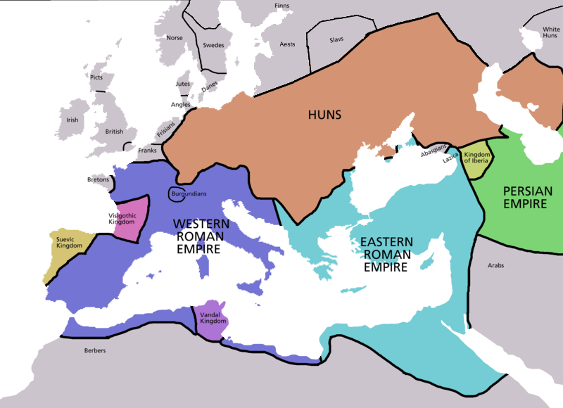
Map of Europe in 450 AD, based on free map of europe Image:BlankMap-Europe.png. Many of the border lines are approximations. Information from Penguin Atlas of Medieval History - and Harper Collins Atlas of World History ed. by Geoffrey Barraclough, second revised edition 1989 pp. 88-89 and pp. 106-107
Maps of the history of Europe
BCE aC
Weichselian ice age (c. 113,000–9700) · Neolithic expansion (c. 7000–4500) · Middle Neolithic (c. 4500–4000) · Late Neolithic (c. 4000–3000) · Copper Age – Corded Ware culture (c. 2900–2350) · Copper Age – Bellbeaker culture (c. 2800–1800) · Early Bronze Age – Unetice culture (c. 2300–1600) · Late Bronze Age – Urnfield culture (c. 1300—750) · Migrations (c. 1000–100) · Hallstatt & La Tène cultures (c. 800–100) · Roman Republic (510–40) · 220 · 218 · 200 · 201–100 · 58 · 49 · 39 · 30 BCE–6 CE
Map of Europe in 220BC, based on free map of europe Image:BlankMap-Europe.png. Many of the border lines are approximations. {{Europe}} Category: Historical maps of Europe
ไฟล, europe, ไฟล, ประว, ไฟล, หน, าท, ภาพน, การใช, ไฟล, วนกลาง, อม, ลเก, ยวก, บภาพไม, ภาพท, รายละเอ, ยดส, งกว, าน, europe, 8206, กเซล, ขนาดไฟล, โลไบต, ชน, ดไมม, image, ปภาพหร, อไฟล, เส, ยงน, นฉบ, บอย, คอมมอนส, รายละเอ, ยดด, านล, าง, เป, นข, อความท, แสดงผลจาก, ไ. ifl prawtiifl hnathimiphaphni karichiflswnklang khxmulekiywkbphaphimmiphaphthimiraylaexiydsungkwani Europe map 450 PNG 8206 800 580 phikesl khnadifl 145 kiolibt chnidimm image png rupphaphhruxiflesiyngni tnchbbxyuthi khxmmxns raylaexiyddanlang epnkhxkhwamthiaesdngphlcak ifltnchbbinkhxmmxns khxmmxnsepnewbistinokhrngkarsahrbekbrwbrwmsuxesri thi khunsamarthchwyid phaphaephnthithangprawtisastrni khwrcathuksrangihmepnkrafiksewketxr sungmikhxdixikhlayprakar duephimetimthikhxmmxns suxtxngkarekbkwadsahrbsarsnethsephimetim hakphaphnimiinrupaebbkrafiksewketxrxyuaelw krunaxpohldaelaaethnthiaemaebbnidwy vector version available i chuxphaphihm i aenanaepnxyangyingihtngchuxiflewketxrihmnninrupaebb Europe map 450 svg aelwisaemaebb Vector version available hrux Vva sungimtxngichpharamietxr chuxphaphihmkhwamyx Espanol Europa en el 450 Map of Europe in 450 AD based on free map of europe Image BlankMap Europe png Many of the border lines are approximations Information from Penguin Atlas of Medieval History and Harper Collins Atlas of World History ed by Geoffrey Barraclough second revised edition 1989 pp 88 89 and pp 106 107 Maps of the history of EuropeBCEaC Weichselian ice age c 113 000 9700 Neolithic expansion c 7000 4500 Middle Neolithic c 4500 4000 Late Neolithic c 4000 3000 Copper Age Corded Ware culture c 2900 2350 Copper Age Bellbeaker culture c 2800 1800 Early Bronze Age Unetice culture c 2300 1600 Late Bronze Age Urnfield culture c 1300 750 Migrations c 1000 100 Hallstatt amp La Tene cultures c 800 100 Roman Republic 510 40 220 218 200 201 100 58 49 39 30 BCE 6 CECEdC 14 14 37 60 60 69 80 Migrations 100 500 117 117 125 Migrations 150 774 Economy 180 271 293 305 337 395 c 395 400 400 450 457 61 476 480 Franks 481 814 Early Slavs 500 700 500 526 526 600 Christianisation to 600 c 550 650 Pontic Steppe 650 665 800 Vikings 800 1050 814 843 70 850 900 912 998 1000 1054 1092 First Crusade 1095 99 1097 1135 1142 1147 49 1190 1190 1250 c 1250 1301 1400 1328 1345 Black Plague 1347 51 1360 1400 Trade routes c 1400 1430 1470 1490 1492 1500 1519 1550 1560 Religion 1560 Religion 1600 Religion 1618 1618 48 1648 1683 1700 1701 1708 1714 1721 1725 30 1739 1740 1740 1748 66 1783 1792 1787 1787 1789 1799 1812 1812 1812 1812 1813 1815 1815 1815 1818 Ottoman Empire 1830 1923 1848 49 1861 1867 1871 1878 1890 1905 1911 1914 1914 1919 1919 29 1923 1929 1930 1940 1941 42 1942 45 Cold War 1947 91 1950 1993 2006 2006 to date this template view discuss karxnuyatichsiththi xnuyatihkhdlxk aeckcayaela hruxddaeprexksarniphayitenguxnikhkhxngsyyaxnuyatexksaresrikhxngknu run 1 2 hruxrunid nbcaknithixxkodymulnithisxftaewresri odyimmiswnidhamaekikh immikhxkhwampkhnaaelapkhlng saenakhxngsyyaxnuyatrwmxyuinswnchux syyaxnuyatexksaresrikhxngknuhttp www gnu org copyleft fdl html GFDL GNU Free Documentation License true trueiflnixyuphayitsyyaxnuyat khriexthifkhxmmxns aebbaesdngthima xnuyataebbediywkn 3 0 tnchbbkhunsamarth thicaaebngpn thicathasaena aeckcay aelasngngandngklawtxip thicaeriyberiyngihm thicaddaeplngngandngklaw phayitenguxnikhtxipni aesdngthima khuntxngihekiyrtiecakhxngnganxyangehmaasm odyephimlingkipyngsyyaxnuyat aelarabuhakmikarepliynaeplng khunxacthaechnniidinrupaebbidkidtamkhwr aettxngimichinlksnathiaenawaphuihxnuyatsnbsnunkhunhruxkarichngankhxngkhun xnuyataebbediywkn hakkhunddaeplng epliynrup hruxtxetimnganni khuntxngichsyyaxnuyataebbediywknhruxaebbthiehmuxnkbsyyaxnuyatthiichkbnganniethannpayaesdngsthanalikhsiththinithukephimephuxihepniptamkarepliynaeplngsyyaxnuyatkhxngmulnithiwikimiediy cak GFDL ipyng GFDL khwbkhukb CC BY SA 3 0 http creativecommons org licenses by sa 3 0 CC BY SA 3 0 Creative Commons Attribution Share Alike 3 0 true truekhabrryayodyyxithyephimkhabrryaythrrthdediywephuxkhyaykhwamwaiflnimixairixethmthiaesdngxyuiniflniprakxbdwysthanalikhsiththimilikhsiththisyyaxnuyatCreative Commons Attribution ShareAlike 3 0 Unported xngkvsGNU Free Documentation License version 1 2 or later xngkvs prawtiifl khlikwnthi ewlaephuxduiflthipraktinkhnann wnthi ewlarupyxkhnadphuichkhwamehn pccubn05 30 5 emsayn 2552800 580 145 kiolibt DJ SturmDetailed Northern Europa 09 52 12 mkrakhm 2550800 580 141 kiolibt Roke commonswiki 20 38 5 phvsphakhm 25492 275 1 649 111 kiolibt Roke commonswikiMap of Europe in 220BC based on free map of europe Image BlankMap Europe png Many of the border lines are approximations Europe Category Historical maps of Europe hnathimiphaphni hnatxipni oyngmathiphaphni smyklang karichiflswnklang wikixuntxipniichiflni karichbn af wikipedia org 450 karichbn ar wikipedia org ويكيبيديا ورشة الصور أرشيف 31 karichbn ast wikipedia org Sieglu V karichbn bar wikipedia org 5 Joarhundad karichbn bs wikipedia org Srednji vijek karichbn ckb wikipedia org سەدەکانی ناوین karichbn cs wikipedia org Theodosius II karichbn da wikipedia org Middelalderen 5 arhundrede karichbn de wikipedia org 5 Jahrhundert karichbn el wikipedia org 5os aiwnas karichbn en wikipedia org 450 User Qunho Portugal User talk Inawe Talk Middle Ages Archive 9 User Falcaorib Talk Middle Ages Archive 10 karichbn en wiktionary org Hunnic Empire karichbn eo wikipedia org Mezepoko karichbn es wikipedia org Siglo V Historia del Caucaso karichbn es wikiquote org Siglo V karichbn et wikipedia org Theodosius II karichbn fa wikipedia org قرون وسطی نبرد آوارایر karichbn fi wikipedia org 400 luku karichbn fr wikipedia org 450 Discussion Projet Haut Moyen Age Archives2 aout octobre 2006 Empire hunnique Histoire de l Occitanie Wikipedia Oracle semaine 5 2008 karichbn fy wikipedia org Falentinianus III Fisigoatyske Ryk Slach oan de Urbikus karichbn gl wikipedia org Alta Idade Media karichbn he wikipedia org 450 karichbn hu wikipedia org Attila hun kiraly 450 karichbn hy wikipedia org Միջնադար karichbn id wikipedia org Abad Pertengahan karichbn io wikipedia org 5ma yarcento karichbn it wikipedia org Valentiniano III Teodosio II Marciano imperatore Senato bizantino karichbn ja wikipedia org ガイセリック 利用者 野島崎沖 作業場13号室 リキメル アンテミウス karichbn ka wikipedia org ჰუნები dukarichthwolkephimetimkhxngiflnikhxmulekiywkbphaph phaphnimikhxmulephimetim sungswnihymacakklxngdicitxlhruxsaeknenxrthisamarthekbkhxmuldngklawiwrwmkbphaphid thaphaphnithukprbprungaekikhhruxepliynaeplngcakedim khxmulbangxyangcayngkhngimepliynaeplngehmuxnphaphthithukprbprungaekikhnnkhwamlaexiydaenwnxn28 34 dpckhwamlaexiydaenwtng28 34 dpcsxftaewrthiichPaint NET v3 36 ekhathungcak https th wikipedia org wiki ifl Europe map 450 PNG, wikipedia, วิกิ หนังสือ, หนังสือ, ห้องสมุด,