This image is a derivative work of the following images:
File:Eyjafjallajökull_volcanic_ash_multilayer.xcf licensed with Cc-by-sa-3.0
2010-04-25T01:29:03Z Cogiati 0x0 (853897 Bytes) added 22 april
2010-04-25T01:17:42Z Cogiati 0x0 (845598 Bytes) added 21 april
2010-04-25T00:01:51Z Cogiati 0x0 (832938 Bytes) added 19 april
2010-04-24T23:20:51Z Cogiati 0x0 (818621 Bytes) added 24 april
2010-04-23T21:13:03Z Cogiati 0x0 (814673 Bytes) added 15 april
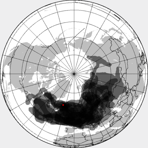
2010-04-23T20:54:25Z Cogiati 0x0 (808456 Bytes) {{Information |Description=This map shows the Icelandic volcanic ash cloud that closed European air space. Every day is shown in a different layer. It's an XCf file editable with GIMP. Based on maps found at http://www.metoff
{{Information |Description=This is a composite map showing the position of the Icelandinc volcanic ash cloud that closed European air space in different days. Based on maps found at http://www.metoffice.gov.uk/aviation/vaac/vaacuk_vag.html Days included:
Air travel disruption after the 2010 Eyjafjallajökull eruption
Effects of the April 2010 Eyjafjallajökull eruption
Tulivuorenpurkaus
Eyjafjallajökullin tulivuorenpurkaus 2010
2010年のエイヤフィヤトラヨークトルの噴火
มกราคม 08, 2023
ไฟล, eyjafjallajökull, volcanic, composite, ไฟล, ประว, ไฟล, หน, าท, ภาพน, การใช, ไฟล, วนกลางขนาดของต, วอย, างน, กเซล, ความละเอ, ยดอ, กเซล, กเซล, กเซล, ภาพท, ความละเอ, ยดส, งกว, 8206, กเซล, ขนาดไฟล, โลไบต, ชน, ดไมม, image, ปภาพหร, อไฟล, เส, ยงน, นฉบ, บอย, คอมมอ. ifl prawtiifl hnathimiphaphni karichiflswnklangkhnadkhxngtwxyangni 600 600 phikesl khwamlaexiydxun 240 240 phikesl 480 480 phikesl 726 726 phikesl duphaphthimikhwamlaexiydsungkwa 8206 726 726 phikesl khnadifl 95 kiolibt chnidimm image png rupphaphhruxiflesiyngni tnchbbxyuthi khxmmxns raylaexiyddanlang epnkhxkhwamthiaesdngphlcak ifltnchbbinkhxmmxns khxmmxnsepnewbistinokhrngkarsahrbekbrwbrwmsuxesri thi khunsamarthchwyid khaxthibayEyjafjallajokull volcanic ash composite png This is a composite map showing the position of the Icelandinc volcanic ash cloud that closed European air space in different days Based on maps found at http www metoffice gov uk aviation vaac vaacuk vag htmlDays included 14 April 2010 12 00 UTC 14 April 2010 18 00 UTC 15 April 2010 18 00 UTC 16 April 2010 18 00 UTC 17 April 2010 18 00 UTC 18 April 2010 18 00 UTC 19 April 2010 18 00 UTC 20 April 2010 18 00 UTC 21 April 2010 18 00 UTC 22 April 2010 18 00 UTC 23 April 2010 18 00 UTC 24 April 2010 18 00 UTC 25 April 2010 18 00 UTCwnthi 25 emsayn ph s 2553 01 32 UTC aehlngthima Eyjafjallajokull volcanic ash multilayer xcfphusrangsrrkh Eyjafjallajokull volcanic ash multilayer xcf Blankmap ao 090N north pole xcf Reisio derivative work Cogiati talk derivative work Cogiati talk phaphni idrbkarprbaetngphaph sunghmaykhwamwacaidrbkarepliynaeplngphaphtangcaktnchbb karprbprung made all day layers visible tnchbbsamarthduidthini Eyjafjallajokull volcanic ash multilayer xcf prbaetngphaphody Cogiati khapheca inthanaphuthuxlikhsiththikhxngphaphhruxsuxni xnuyatihichphaphhruxsuxniphayitenguxnikhtxipniiflnixyuphayitsyyaxnuyat khriexthifkhxmmxns aebbaesdngthima xnuyataebbediywkn 3 0 tnchbbkhunsamarth thicaaebngpn thicathasaena aeckcay aelasngngandngklawtxip thicaeriyberiyngihm thicaddaeplngngandngklaw phayitenguxnikhtxipni aesdngthima khuntxngihekiyrtiecakhxngnganxyangehmaasm odyephimlingkipyngsyyaxnuyat aelarabuhakmikarepliynaeplng khunxacthaechnniidinrupaebbidkidtamkhwr aettxngimichinlksnathiaenawaphuihxnuyatsnbsnunkhunhruxkarichngankhxngkhun xnuyataebbediywkn hakkhunddaeplng epliynrup hruxtxetimnganni khuntxngichsyyaxnuyataebbediywknhruxaebbthiehmuxnkbsyyaxnuyatthiichkbnganniethannhttps creativecommons org licenses by sa 3 0 CC BY SA 3 0 Creative Commons Attribution Share Alike 3 0 true true bnthukkarxphohld This image is a derivative work of the following images File Eyjafjallajokull volcanic ash multilayer xcf licensed with Cc by sa 3 0 2010 04 25T01 29 03Z Cogiati 0x0 853897 Bytes added 22 april 2010 04 25T01 17 42Z Cogiati 0x0 845598 Bytes added 21 april 2010 04 25T00 01 51Z Cogiati 0x0 832938 Bytes added 19 april 2010 04 24T23 20 51Z Cogiati 0x0 818621 Bytes added 24 april 2010 04 23T21 13 03Z Cogiati 0x0 814673 Bytes added 15 april 2010 04 23T20 54 25Z Cogiati 0x0 808456 Bytes Information Description This map shows the Icelandic volcanic ash cloud that closed European air space Every day is shown in a different layer It s an XCf file editable with GIMP Based on maps found at http www metoffUploaded with derivativeFXkhabrryayodyyxithyephimkhabrryaythrrthdediywephuxkhyaykhwamwaiflnimixairixethmthiaesdngxyuiniflniprakxbdwysthanalikhsiththimilikhsiththisyyaxnuyatCreative Commons Attribution ShareAlike 3 0 Unported xngkvswnthisrang wnkxtng25 emsayn 2010 prawtiifl khlikwnthi ewlaephuxduiflthipraktinkhnann wnthi ewlarupyxkhnadphuichkhwamehn pccubn21 53 27 emsayn 2553726 726 95 kiolibt Cogiatiadded 17 april 21 09 26 emsayn 2553726 726 93 kiolibt Cogiatiadded 18 april 14 32 26 emsayn 2553726 726 92 kiolibt Cogiatiadded 25 April 23 00 25 emsayn 2553726 726 91 kiolibt Cogiatiadded 16 april 08 56 25 emsayn 2553726 726 90 kiolibt Cogiatiadded 20 april 08 32 25 emsayn 2553726 726 88 kiolibt Cogiati Information Description This is a composite map showing the position of the Icelandinc volcanic ash cloud that closed European air space in different days Based on maps found at http www metoffice gov uk aviation vaac vaacuk vag html Days included hnathimiphaphni hnatxipni oyngmathiphaphni karpathukhxngexyafyatlaeyxkhutl ph s 2553 ph s 2553 karichiflswnklang wikixuntxipniichiflni karichbn ca wikipedia org Erupcions de l Eyjafjalla del 2010 karichbn da wikipedia org Luftfartsproblemerne efter Eyjafjallajokulls vulkanudbrud 2010 Eyjafjallajokulls vulkanudbrud i 2010 karichbn de wikipedia org Ausbruch des Eyjafjallajokull 2010 karichbn en wikipedia org 2010 eruptions of Eyjafjallajokull Air travel disruption after the 2010 Eyjafjallajokull eruption Effects of the April 2010 Eyjafjallajokull eruption karichbn es wikipedia org Anexo Cronologia de la erupcion del Eyjafjallajokull de 2010 karichbn eu wikipedia org 2010eko Eyjafjallajokullen erupzioak karichbn fi wikipedia org Tulivuori Tulivuorenpurkaus Eyjafjallajokullin tulivuorenpurkaus 2010 karichbn hu wikipedia org Legterzar az Eyjafjallajokull vulkan 2010 es kitorese utan karichbn it wikipedia org Eruzione dell Eyjafjoll del 2010 karichbn ja wikipedia org 2010年のエイヤフィヤトラヨークトルの噴火による交通麻痺 2010年のエイヤフィヤトラヨークトルの噴火 karichbn pt wikipedia org Erupcoes do Eyjafjallajokull em 2010 karichbn ru wikipedia org Vliyanie izverzheniya vulkana Ejyafyadlajyokyudl na mezhdunarodnoe aviasoobshenie karichbn ur wikipedia org ایفیاتلایوکوتل کا انفجار 2010ء karichbn vi wikipedia org Phun trao Eyjafjallajokull 2010 karichbn zh wikipedia org 2010年埃亚菲亚德拉火山爆发 ekhathungcak https th wikipedia org wiki ifl Eyjafjallajokull volcanic ash composite png, wikipedia, วิกิ หนังสือ, หนังสือ, ห้องสมุด,