รูปภาพหรือไฟล์เสียงนี้ ต้นฉบับอยู่ที่ คอมมอนส์ รายละเอียดด้านล่าง เป็นข้อความที่แสดงผลจาก ไฟล์ต้นฉบับในคอมมอนส์ คอมมอนส์เป็นเว็บไซต์ในโครงการสำหรับเก็บรวบรวมสื่อเสรี ที่ คุณสามารถช่วยได้
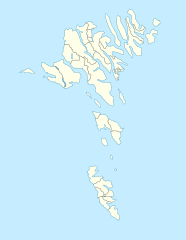
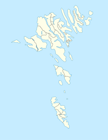
ความย่อ คำอธิบายFaroe Islands location map.svg English: Location map of the Faroe Islands
Equirectangular projection, N/S stretching 213 %. Geographic limits of the map:
N: 62.44° N S: 61.30° N W: 7.88° W E: 6.00° W Deutsch: Positionskarte der Färöer
Quadratische Plattkarte, N-S-Streckung 213 %. Geographische Begrenzung der Karte:
N: 62.44° N S: 61.30° N W: 7.88° W O: 6.00° W วันที่ 7 มีนาคม พ.ศ. 2552 แหล่งที่มา งานของตัว ผู้สร้างสรรค์ Erik Frohne เวอร์ชันอื่น ไฟล์อื่นที่ใช้ไฟล์นี้: Strandfaraskip route map.svg
Municipalities of the faroe islands 2005.png SVG genesisInfoField
ซอร์สโค้ดของไฟล์ SVG นี้ไม่ถูกต้อง 2
ไฟล์ภาพกราฟิกส์เวกเตอร์ W3C ตรวจสอบแล้วมีข้อผิดพลาดในไฟล์ นี้ สร้างขึ้นโดยใช้ Inkscape, or with something else .
การอนุญาตใช้สิทธิ ข้าพเจ้า ในฐานะผู้ถือลิขสิทธิ์ของภาพหรือสื่อนี้ อนุญาตให้ใช้ภาพหรือสื่อนี้ภายใต้เงื่อนไขต่อไปนี้
อนุญาตให้คัดลอก แจกจ่ายและ/หรือดัดแปรเอกสารนี้ภายใต้เงื่อนไขของสัญญาอนุญาตเอกสารเสรีของกนู รุ่น 1.2 หรือรุ่นใด ๆ นับจากนี้ที่ออกโดยมูลนิธิซอฟต์แวร์เสรี โดยไม่มีส่วนใดห้ามแก้ไข ไม่มีข้อความปกหน้าและปกหลัง สำเนาของสัญญาอนุญาตรวมอยู่ในส่วนชื่อ สัญญาอนุญาตเอกสารเสรีของกนู http://www.gnu.org/copyleft/fdl.html GFDL GNU Free Documentation License true true
ไฟล์นี้อยู่ภายใต้สัญญาอนุญาต ครีเอทีฟคอมมอนส์ แบบแสดงที่มา-อนุญาตแบบเดียวกัน 3.0 ต้นฉบับ
คุณสามารถ: ที่จะแบ่งปัน – ที่จะทำสำเนา แจกจ่าย และส่งงานดังกล่าวต่อไปที่จะเรียบเรียงใหม่ – ที่จะดัดแปลงงานดังกล่าว ภายใต้เงื่อนไขต่อไปนี้: แสดงที่มา – คุณต้องให้เกียรติเจ้าของงานอย่างเหมาะสม โดยเพิ่มลิงก์ไปยังสัญญาอนุญาต และระบุหากมีการเปลี่ยนแปลง คุณอาจทำเช่นนี้ได้ในรูปแบบใดก็ได้ตามควร แต่ต้องไม่ใช่ในลักษณะที่แนะว่าผู้ให้อนุญาตสนับสนุนคุณหรือการใช้งานของคุณอนุญาตแบบเดียวกัน – หากคุณดัดแปลง เปลี่ยนรูป หรือต่อเติมงานนี้ คุณต้องใช้สัญญาอนุญาตแบบเดียวกันหรือแบบที่เหมือนกับสัญญาอนุญาตที่ใช้กับงานนี้เท่านั้น https://creativecommons.org/licenses/by-sa/3.0 CC BY-SA 3.0 Creative Commons Attribution-Share Alike 3.0 true true คุณสามารถเลือกสัญญาอนุญาตดังกล่าวตามต้องการ
ไทย เพิ่มคำบรรยายทรรทัดเดียวเพื่อขยายความว่าไฟล์นี้มีอะไร
อังกฤษ Location map of the Faroe Islands
ประวัติไฟล์ คลิกวันที่/เวลาเพื่อดูไฟล์ที่ปรากฏในขณะนั้น
วันที่/เวลา รูปย่อ ขนาด ผู้ใช้ ความเห็น ปัจจุบัน 20:27, 20 ธันวาคม 2563 775 × 1,000 (63 กิโลไบต์) Hanzlan Húsar merged with Klaksvík 19:58, 29 เมษายน 2553 775 × 1,000 (77 กิโลไบต์) Erik Frohne Removal of some borders according to http://www.us.fo/Default.aspx?ID=5497&M=News&PID=6574&NewsID=1842&CATID=29 21:46, 7 มีนาคม 2552 775 × 1,000 (79 กิโลไบต์) Erik Frohne {{Information |Description={{en|1=Location map of the Faroe Islands Equirectangular projection, N/S stretching 213 %. Geographic limits of the map: * N: 62.44° N * S: 61.30° N * W: 7.88° W * E: 6.00° W}} {{de|1=Positionskarte der Färöer Quadra
หน้าที่มีภาพนี้ หน้าต่อไปนี้ โยงมาที่ภาพนี้:
การใช้ไฟล์ส่วนกลาง วิกิอื่นต่อไปนี้ใช้ไฟล์นี้:
Tórshavn قاوسا دولار Módulu:Minimapa/data/Islles Feroe Aeropuertu de Vágar Módulu:Minimapa/data/Islles Feroe/usu Гэстур Барой Мічынэс (востраў) Кальтур Куной Стоўра-Дуймун Кляксвуйк Гойвік Аргір Фугляф’ёрдур Воавур Вэстмана Мідвоавур Сёрвоавур Шаблён:Лякалізацыйная мапа Даніі (Фарэрскія астравы) Стрэймай Хестур Фуглай Эстурай Слаттаратындур Сандай Мічынес Скувай Борай Кальсай Кольтур Шаблон:На карце/Данія Фарэрскія астравы Кунай Стоўра-Дуймун Ноўльсай Воар Луйтла-Дуймун Віяй Свуйнай Хойвік Клаксвуйк Фуглафіёрдур ดูการใช้ทั่วโลกเพิ่มเติม ของไฟล์นี้
ภาพนี้มีข้อมูลเพิ่มเติม ซึ่งส่วนใหญ่มาจากกล้องดิจิตอลหรือสแกนเนอร์ที่สามารถเก็บข้อมูลดังกล่าวไว้รวมกับภาพได้ ถ้าภาพนี้ถูกปรับปรุงแก้ไขหรือเปลี่ยนแปลงจากเดิม ข้อมูลบางอย่างจะยังคงไม่เปลี่ยนแปลงเหมือนภาพที่ถูกปรับปรุงแก้ไขนั้น
ไฟล, faroe, islands, location, ไฟล, ประว, ไฟล, หน, าท, ภาพน, การใช, ไฟล, วนกลาง, อม, ลเก, ยวก, บภาพขนาดของต, วอย, าง, ของไฟล, กเซล, ความละเอ, ยดอ, กเซล, กเซล, กเซล, กเซล, กเซล, กเซล, ภาพท, ความละเอ, ยดส, งกว, 8206, ไฟล, กเซล, ขนาดไฟล, โลไบต, ปภาพหร, อไฟล, เส, . ifl prawtiifl hnathimiphaphni karichiflswnklang khxmulekiywkbphaphkhnadkhxngtwxyang PNG nikhxngifl SVG ni 465 600 phikesl khwamlaexiydxun 186 240 phikesl 372 480 phikesl 595 768 phikesl 793 1 024 phikesl 1 587 2 048 phikesl 775 1 000 phikesl duphaphthimikhwamlaexiydsungkwa 8206 ifl SVG 775 1 000 phikesl khnadifl 63 kiolibt rupphaphhruxiflesiyngni tnchbbxyuthi khxmmxns raylaexiyddanlang epnkhxkhwamthiaesdngphlcak ifltnchbbinkhxmmxns khxmmxnsepnewbistinokhrngkarsahrbekbrwbrwmsuxesri thi khunsamarthchwyid khwamyx khaxthibayFaroe Islands location map svg English Location map of the Faroe Islands Equirectangular projection N S stretching 213 Geographic limits of the map N 62 44 N S 61 30 N W 7 88 W E 6 00 W Deutsch Positionskarte der Faroer Quadratische Plattkarte N S Streckung 213 Geographische Begrenzung der Karte N 62 44 N S 61 30 N W 7 88 W O 6 00 Wwnthi 7 minakhm ph s 2552aehlngthima ngankhxngtwphusrangsrrkh Erik Frohneewxrchnxun iflxunthiichiflni Strandfaraskip route map svg Municipalities of the faroe islands 2005 pngSVG genesisInfoField sxrsokhdkhxngifl SVG niimthuktxng enuxngcakphbkhxphidphlad2 aehng iflphaphkrafiksewketxr W3C trwcsxbaelwmikhxphidphladiniflni srangkhunodyich Inkscape or with something else karxnuyatichsiththi khapheca inthanaphuthuxlikhsiththikhxngphaphhruxsuxni xnuyatihichphaphhruxsuxniphayitenguxnikhtxipni xnuyatihkhdlxk aeckcayaela hruxddaeprexksarniphayitenguxnikhkhxngsyyaxnuyatexksaresrikhxngknu run 1 2 hruxrunid nbcaknithixxkodymulnithisxftaewresri odyimmiswnidhamaekikh immikhxkhwampkhnaaelapkhlng saenakhxngsyyaxnuyatrwmxyuinswnchux syyaxnuyatexksaresrikhxngknuhttp www gnu org copyleft fdl html GFDL GNU Free Documentation License true trueiflnixyuphayitsyyaxnuyat khriexthifkhxmmxns aebbaesdngthima xnuyataebbediywkn 3 0 tnchbbkhunsamarth thicaaebngpn thicathasaena aeckcay aelasngngandngklawtxip thicaeriyberiyngihm thicaddaeplngngandngklaw phayitenguxnikhtxipni aesdngthima khuntxngihekiyrtiecakhxngnganxyangehmaasm odyephimlingkipyngsyyaxnuyat aelarabuhakmikarepliynaeplng khunxacthaechnniidinrupaebbidkidtamkhwr aettxngimichinlksnathiaenawaphuihxnuyatsnbsnunkhunhruxkarichngankhxngkhun xnuyataebbediywkn hakkhunddaeplng epliynrup hruxtxetimnganni khuntxngichsyyaxnuyataebbediywknhruxaebbthiehmuxnkbsyyaxnuyatthiichkbnganniethannhttps creativecommons org licenses by sa 3 0 CC BY SA 3 0 Creative Commons Attribution Share Alike 3 0 true truekhunsamartheluxksyyaxnuyatdngklawtamtxngkarkhabrryayodyyxithyephimkhabrryaythrrthdediywephuxkhyaykhwamwaiflnimixairxngkvsLocation map of the Faroe Islandsixethmthiaesdngxyuiniflniprakxbdwyhmuekaaaeforphusrangbangkhathiimmiixethmwikisnethschuxphusrangsrrkh Erik Frohnechuxphuichwikimiediy Erik Frohneyuxaraexl http commons wikimedia org wiki User Erik FrohnesthanalikhsiththimilikhsiththisyyaxnuyatGNU Free Documentation License version 1 2 or later xngkvsCreative Commons Attribution ShareAlike 3 0 Unported xngkvswnthisrang wnkxtng7 minakhm 2009thimakhxngiflkarsrangdngedimodyphuxpohld prawtiifl khlikwnthi ewlaephuxduiflthipraktinkhnann wnthi ewlarupyxkhnadphuichkhwamehn pccubn20 27 20 thnwakhm 2563775 1 000 63 kiolibt HanzlanHusar merged with Klaksvik 19 58 29 emsayn 2553775 1 000 77 kiolibt Erik FrohneRemoval of some borders according to http www us fo Default aspx ID 5497 amp M News amp PID 6574 amp NewsID 1842 amp CATID 29 21 46 7 minakhm 2552775 1 000 79 kiolibt Erik Frohne Information Description en 1 Location map of the Faroe Islands Equirectangular projection N S stretching 213 Geographic limits of the map N 62 44 N S 61 30 N W 7 88 W E 6 00 W de 1 Positionskarte der Faroer Quadra hnathimiphaphni hnatxipni oyngmathiphaphni thxrechan aemaebb Location map Faroe Islands mxdul Location map data Denmark Faroe Islands mxdul Location map data Denmark Faroe Islands doc mxdul Location map data Faroe Islands karichiflswnklang wikixuntxipniichiflni karichbn af wikipedia org Sjabloon Liggingkaart Faroereilande karichbn an wikipedia org Plantilla Mapa de localizacion Islas Feroe Torshavn karichbn ar wikipedia org قالب خريطة مواقع جزر فارو قاوسا دولار karichbn ast wikipedia org Torsḥavn Modulu Minimapa data Islles Feroe Aeropuertu de Vagar Modulu Minimapa data Islles Feroe usu karichbn az wikipedia org Sablon Yer xeritesi Danimarka Farer adalari karichbn ba wikipedia org Ҡalyp PozKarta Daniya Farer utrauҙary karichbn be tarask wikipedia org Torsgayn Gestur Baroj Michynes vostray Kaltur Kunoj Stoyra Dujmun Klyaksvujk Gojvik Argir Fuglyaf yordur Voavur Vestmana Midvoavur Syorvoavur Shablyon Lyakalizacyjnaya mapa Danii Farerskiya astravy karichbn be wikipedia org Torshayn Strejmaj Hestur Fuglaj Esturaj Slattaratyndur Sandaj Michynes Skuvaj Boraj Kalsaj Koltur Shablon Na karce Daniya Farerskiya astravy Kunaj Stoyra Dujmun Noylsaj Voar Lujtla Dujmun Viyaj Svujnaj Hojvik Klaksvujk Fuglafiyordur dukarichthwolkephimetimkhxngiflnikhxmulekiywkbphaph phaphnimikhxmulephimetim sungswnihymacakklxngdicitxlhruxsaeknenxrthisamarthekbkhxmuldngklawiwrwmkbphaphid thaphaphnithukprbprungaekikhhruxepliynaeplngcakedim khxmulbangxyangcayngkhngimepliynaeplngehmuxnphaphthithukprbprungaekikhnnkhwamkwang775 198khwamsung1000 ekhathungcak https th wikipedia org wiki ifl Faroe Islands location map svg, wikipedia, วิกิ หนังสือ, หนังสือ, ห้องสมุด,
บทความ , อ่าน, ดาวน์โหลด, ฟรี, ดาวน์โหลดฟรี, mp3, วิดีโอ, mp4, 3gp, jpg, jpeg, gif, png, รูปภาพ, เพลง, เพลง, หนัง, หนังสือ, เกม, เกม