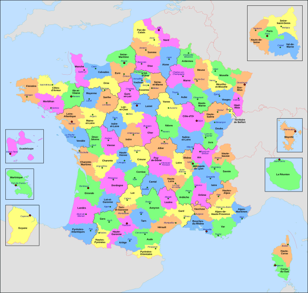
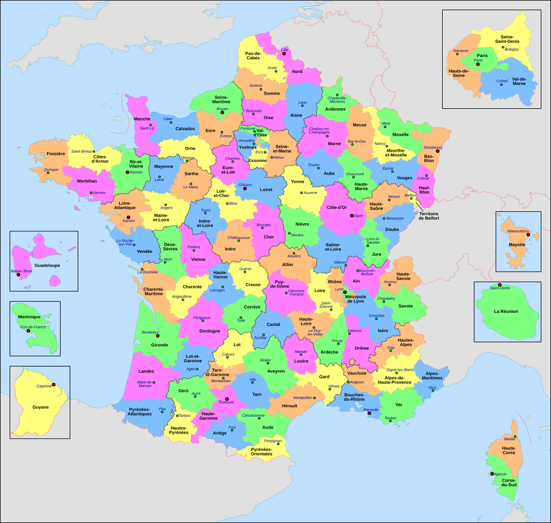
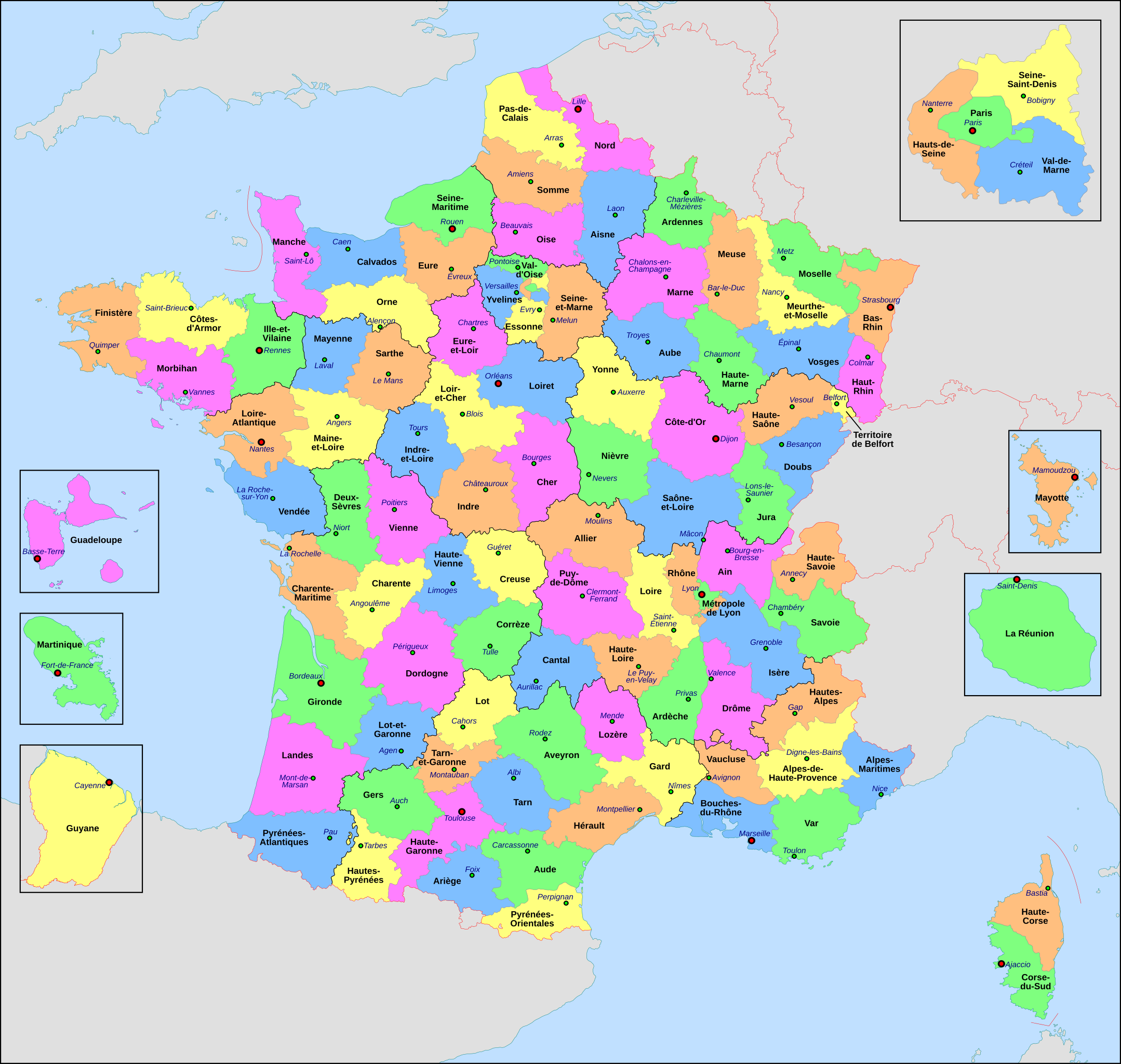
Français : Carte administrative de la France, créée sous Inkscape 0.47 à partir de plusieurs des excellentes cartes (notamment celle-ci) créées par Sting : merci (et bravo) à lui.
Le fichier comporte vingt-quatre calques : Cadre, Chef-lieux de région, Villes, Chef-lieux de département, Numéros de département, Noms des régions, Nom des départements, **Encarts Départements d'Outre-Mer, **Encart Paris-Petite-Couronne, Coordonnées, Échelle et Mini-carte, Frontières internationales, Côtes, Limites régionales, Limites départementales, Lacs, Fleuves, *Régions métropolitaines, *Départements métropolitains, Terres françaises, Terres étrangères, Mers et océans, Échelle altimétrique, Topographie.
Calque visible Calque caché
L'astérisque signale un calque comportant des sous-calques
La double astérisque signale un calque comportant des sous-calques dont certains comportent eux-mêmes des sous-calques
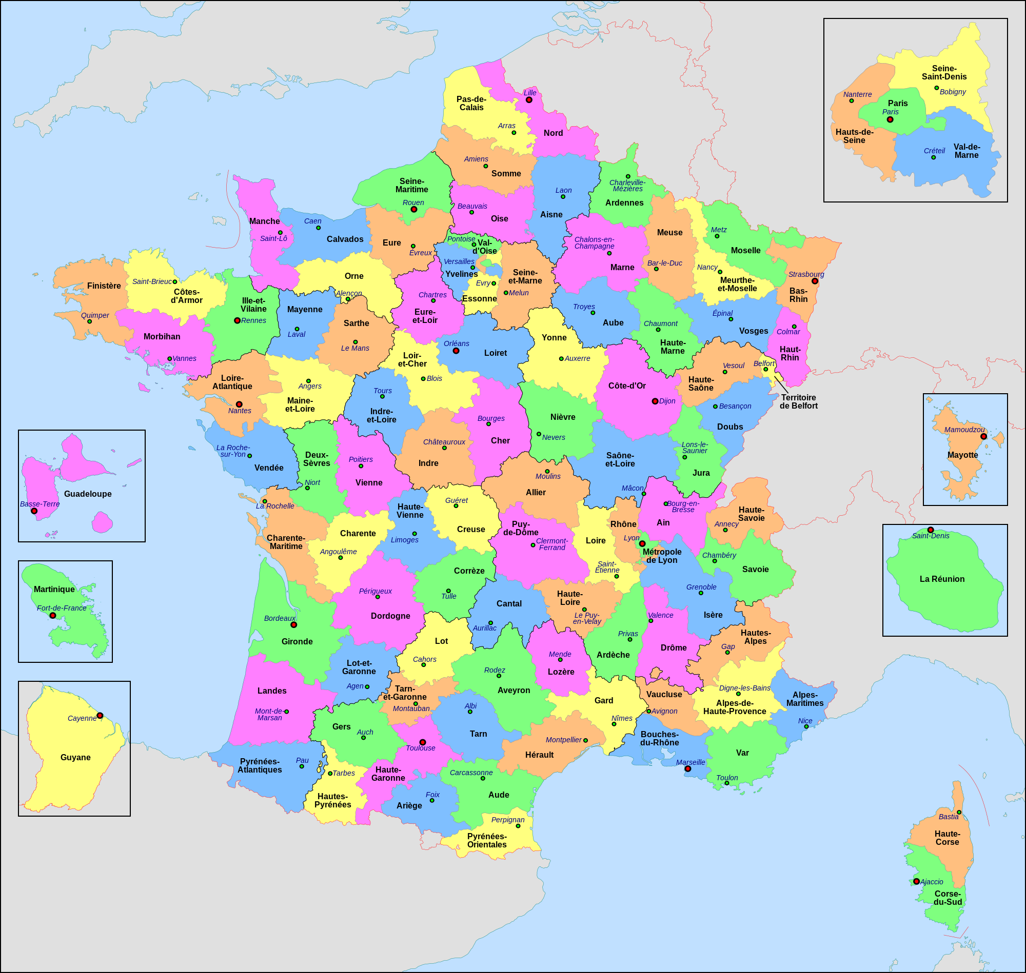
English: Administrative map of France, created under Inkscape 0.47 from several of the excellent maps (especially this one) created by Sting: thanks (and congrats) to him.
The file consists of twenty-four layers: Frame, Administrative Centres of Regions, Towns, Administrative Centres of Departments, Numbers of Departments, Names of Regions, Names of Departments, **Overseas Departements Insets, **Paris Conurbation Inset, Coordinates, Scale and Mini-map, International boundaries, Coasts, Regional boundaries, Departmental boundaries, Lakes, Rivers, *Metropolitan Regions, *Metropolitan Departments, French lands, Foreign lands, Seas and Oceans, Altimetric Scale, Topography.
Visible Layer Hidden Layer
The asterisk indicates a layer with sublayers
The double asterisk indicates a layer with sublayers, some of which have sublayers
This image is used on a user page of a Wikimedia user and is stored on Commons according to the rules set out in Commons:Project scope#File in use on Commons only: the uploading of small numbers of images (e.g. of yourself) for use on a personal Commons user page is allowed or Commons:Project scope#File in use in another Wikimedia project: the uploading of small numbers of images (e.g. of yourself) for use on a personal user page of another project is allowed as long as that user is or was an active participant on that project. If the image ceases to be used it may be eligible for deletion as it may have no educational purpose.
dansk ∙ Deutsch ∙ English ∙ español ∙ français ∙ italiano ∙ Nederlands ∙ português ∙ sicilianu ∙ svenska ∙ македонски ∙ नेपाली ∙ മലയാളം ∙ 한국어 ∙ 日本語 ∙ 中文(简体) ∙ 中文(繁體) ∙ +/−
ไฟล, france, départementale, ไฟล, ประว, ไฟล, หน, าท, ภาพน, การใช, ไฟล, วนกลาง, อม, ลเก, ยวก, บภาพขนาดของต, วอย, าง, ของไฟล, กเซล, ความละเอ, ยดอ, กเซล, กเซล, กเซล, กเซล, กเซล, กเซล, ภาพท, ความละเอ, ยดส, งกว, 8206, ไฟล, กเซล, ขนาดไฟล, เมกะไบต, ปภาพหร, อไฟล, เส, . ifl prawtiifl hnathimiphaphni karichiflswnklang khxmulekiywkbphaphkhnadkhxngtwxyang PNG nikhxngifl SVG ni 632 600 phikesl khwamlaexiydxun 253 240 phikesl 506 480 phikesl 809 768 phikesl 1 079 1 024 phikesl 2 158 2 048 phikesl 2 000 1 898 phikesl duphaphthimikhwamlaexiydsungkwa 8206 ifl SVG 2 000 1 898 phikesl khnadifl 1 87 emkaibt rupphaphhruxiflesiyngni tnchbbxyuthi khxmmxns raylaexiyddanlang epnkhxkhwamthiaesdngphlcak ifltnchbbinkhxmmxns khxmmxnsepnewbistinokhrngkarsahrbekbrwbrwmsuxesri thi khunsamarthchwyid khwamyx khaxthibayFrance departementale svg Francais Carte administrative de la France creee sous Inkscape 0 47 a partir de plusieurs des excellentes cartes notamment celle ci creees par Sting merci et bravo a lui Le fichier comporte vingt quatre calques Cadre Chef lieux de region Villes Chef lieux de departement Numeros de departement Noms des regions Nom des departements Encarts Departements d Outre Mer Encart Paris Petite Couronne Coordonnees Echelle et Mini carte Frontieres internationales Cotes Limites regionales Limites departementales Lacs Fleuves Regions metropolitaines Departements metropolitains Terres francaises Terres etrangeres Mers et oceans Echelle altimetrique Topographie Calque visible Calque cache L asterisque signale un calque comportant des sous calques La double asterisque signale un calque comportant des sous calques dont certains comportent eux memes des sous calques English Administrative map of France created under Inkscape 0 47 from several of the excellent maps especially this one created by Sting thanks and congrats to him The file consists of twenty four layers Frame Administrative Centres of Regions Towns Administrative Centres of Departments Numbers of Departments Names of Regions Names of Departments Overseas Departements Insets Paris Conurbation Inset Coordinates Scale and Mini map International boundaries Coasts Regional boundaries Departmental boundaries Lakes Rivers Metropolitan Regions Metropolitan Departments French lands Foreign lands Seas and Oceans Altimetric Scale Topography Visible Layer Hidden Layer The asterisk indicates a layer with sublayers The double asterisk indicates a layer with sublayers some of which have sublayerswnthi 25 krkdakhm ph s 2553aehlngthima ngankhxngtwphusrangsrrkh Nilstilarewxrchnxun arpetan catala makedonskiSVG genesisInfoField sxrsokhdkhxng SVG nitrwcsxbthuktxngaelw iflphaphkrafiksewketxrni srangkhunodyich Inkscape This map uses embedded text that can be easily translated using a text editor karxnuyatichsiththi khapheca inthanaphuthuxlikhsiththikhxngphaphhruxsuxni xnuyatihichphaphhruxsuxniphayitenguxnikhtxipniiflnixyuphayitsyyaxnuyat khriexthifkhxmmxns aebbaesdngthima xnuyataebbediywkn 4 0 nanachatikhunsamarth thicaaebngpn thicathasaena aeckcay aelasngngandngklawtxip thicaeriyberiyngihm thicaddaeplngngandngklaw phayitenguxnikhtxipni aesdngthima khuntxngihekiyrtiecakhxngnganxyangehmaasm odyephimlingkipyngsyyaxnuyat aelarabuhakmikarepliynaeplng khunxacthaechnniidinrupaebbidkidtamkhwr aettxngimichinlksnathiaenawaphuihxnuyatsnbsnunkhunhruxkarichngankhxngkhun xnuyataebbediywkn hakkhunddaeplng epliynrup hruxtxetimnganni khuntxngichsyyaxnuyataebbediywknhruxaebbthiehmuxnkbsyyaxnuyatthiichkbnganniethannhttps creativecommons org licenses by sa 4 0 CC BY SA 4 0 Creative Commons Attribution Share Alike 4 0 true true This image is used on a user page of a Wikimedia user and is stored on Commons according to the rules set out in Commons Project scope File in use on Commons only the uploading of small numbers of images e g of yourself for use on a personal Commons user page is allowed or Commons Project scope File in use in another Wikimedia project the uploading of small numbers of images e g of yourself for use on a personal user page of another project is allowed as long as that user is or was an active participant on that project If the image ceases to be used it may be eligible for deletion as it may have no educational purpose dansk Deutsch English espanol francais italiano Nederlands portugues sicilianu svenska makedonski न प ल മലയ ള 한국어 日本語 中文 简体 中文 繁體 khabrryayodyyxithyephimkhabrryaythrrthdediywephuxkhyaykhwamwaiflnimixairfrngessDJ STARixethmthiaesdngxyuiniflniprakxbdwycnghwdkhxngpraethsfrngessphusrangbangkhathiimmiixethmwikisnethschuxphusrangsrrkh Nilstilarchuxphuichwikimiediy Nilstilaryuxaraexl http commons wikimedia org wiki User NilstilarsthanalikhsiththimilikhsiththisyyaxnuyatCreative Commons Attribution ShareAlike 4 0 International xngkvswnthisrang wnkxtng25 krkdakhm 2010thimakhxngiflkarsrangdngedimodyphuxpohldMIME type xngkvsimage svg xml prawtiifl khlikwnthi ewlaephuxduiflthipraktinkhnann lasud ekasud du ihmkwa 10 ekakwa 10 10 20 50 100 250 500 wnthi ewlarupyxkhnadphuichkhwamehn pccubn03 29 23 mithunayn 25652 000 1 898 1 87 emkaibt OpesMentisAdded hyphens on departments 039 names and towns 039 names and fixed Reunion to La Reunion 01 10 10 phvscikayn 25642 000 1 898 1 87 emkaibt Puck04fixed SVG code was W3C invalid cleanup using text editor contains some invisible pathes 07 40 1 phvsphakhm 25632 000 1 898 4 7 emkaibt ChrisPtDeFile uploaded using svgtranslate tool https tools wmflabs org svgtranslate Added translation for frp 05 17 29 emsayn 25632 000 1 898 4 7 emkaibt ChrisPtDeFile uploaded using svgtranslate tool https tools wmflabs org svgtranslate Added translation for frp 05 56 26 emsayn 25632 000 1 898 4 68 emkaibt ChrisPtDeFile uploaded using svgtranslate tool https tools wmflabs org svgtranslate Added translation for frp 21 13 4 phvscikayn 25612 000 1 898 4 55 emkaibt NilstilarCorse reunifiee pose probleme 19 05 4 phvscikayn 25612 000 1 898 4 54 emkaibt NilstilarCorse reunifiee collectivite territoriale unique departement amp region au 1 1 2018 20 01 15 tulakhm 25612 000 1 898 4 55 emkaibt NilstilarReverted to version as of 18 52 10 May 2017 UTC 05 30 29 thnwakhm 25602 000 1 898 2 24 emkaibt Ras67frame removed all invisible data stripped 01 52 11 phvsphakhm 25602 000 1 898 4 55 emkaibt NilstilarRetablissement des limites regionales au 01 10 2016 lasud ekasud du ihmkwa 10 ekakwa 10 10 20 50 100 250 500 hnathimiphaphni hnatxipni oyngmathiphaphni cnghwdkhxngpraethsfrngess karichiflswnklang wikixuntxipniichiflni karichbn ar wikipedia org ويكيبيديا ويكيبيديا مشروع ويكي جغرافيا مهمة الأقاليم الفرنسية karichbn ast wikipedia org Departamentos de Francia karichbn ast wiktionary org departamentu karichbn az wikipedia org Fransanin inzibati bolgusu karichbn bg wikipedia org Departamenti na Franciya karichbn br wikipedia org Departamant gall karichbn ca wikipedia org Plaques de matricula de Franca karichbn cy wikipedia org Departements Ffrainc karichbn el wikipedia org Katalogos gallikwn nomwn Nomoi ths Gallias karichbn en wikipedia org County Departments of France karichbn es wikipedia org Organizacion territorial de Francia Condado Departamentos de Francia Categoria Consejos departamentales de Francia karichbn eu wikipedia org Frantzia Frantziako departamendu karichbn fr wikipedia org Departement francais Monument historique France Geographie de la Guadeloupe Economie de la Guadeloupe Liste des ponts de Paris Geographie de la Drome Liste des anciennes communes du Loiret Economie de La Reunion Politique dans la Haute Vienne Politique dans la Creuse Climat des Yvelines Geographie du Territoire de Belfort Culture en Guyane Economie du Puy de Dome Geographie de la Charente Maritime Economie de l Oise Economie de la Haute Savoie Climat de l Aveyron Climat du Bas Rhin Climat du Haut Rhin Geographie du Loiret Arboretum de Balaine Economie de la Haute Saone Climat du Finistere Politique a La Reunion Geographie d Eure et Loir Liste des musees de Paris Concours des villes et villages fleuris Climat du Puy de Dome Geographie des Yvelines Culture dans l Indre Transports a La Reunion dukarichthwolkephimetimkhxngiflnikhxmulekiywkbphaph phaphnimikhxmulephimetim sungswnihymacakklxngdicitxlhruxsaeknenxrthisamarthekbkhxmuldngklawiwrwmkbphaphid thaphaphnithukprbprungaekikhhruxepliynaeplngcakedim khxmulbangxyangcayngkhngimepliynaeplngehmuxnphaphthithukprbprungaekikhnnkhwamkwang2000khwamsung1898 ekhathungcak https th wikipedia org wiki ifl France departementale svg, wikipedia, วิกิ หนังสือ, หนังสือ, ห้องสมุด,