This file is licensed under the Creative Commons Attribution-Share Alike 4.0 International, 3.0 Unported, 2.5 Generic, 2.0 Generic and 1.0 Generic license.
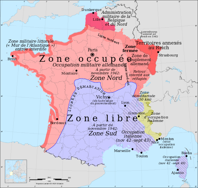
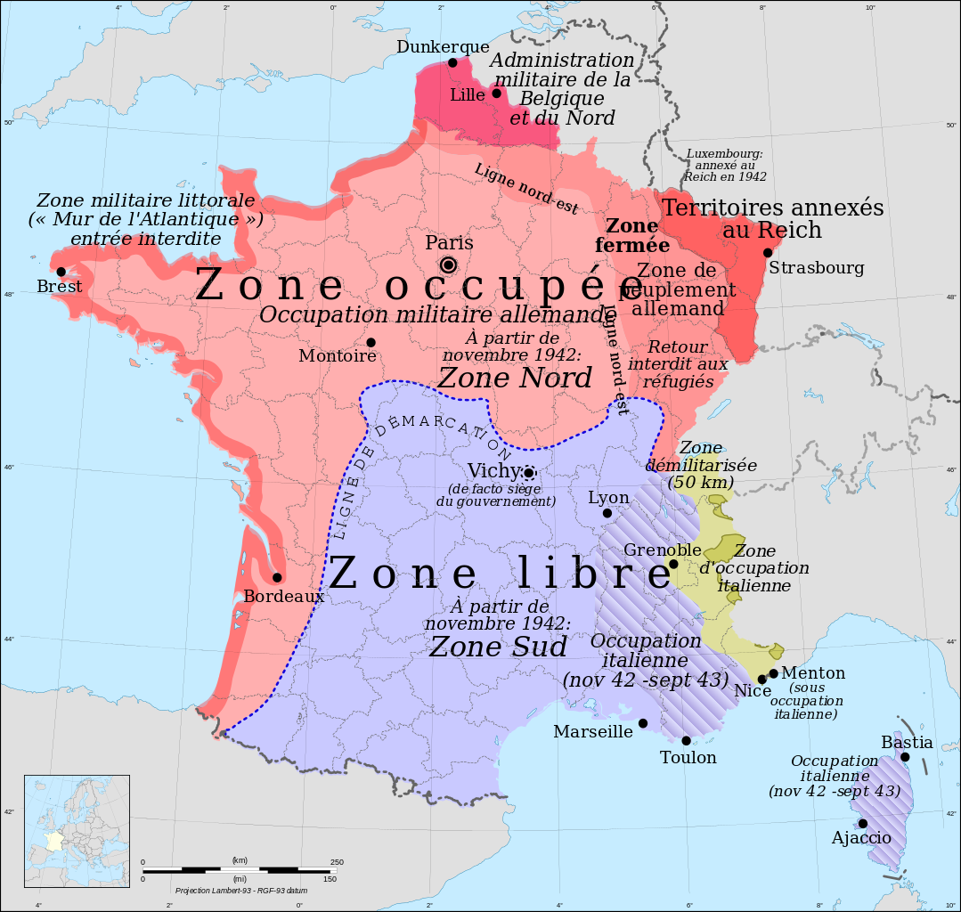
ไฟล, france, lambert, with, regions, departments, occupation, ไฟล, ประว, ไฟล, หน, าท, ภาพน, การใช, ไฟล, วนกลาง, อม, ลเก, ยวก, บภาพขนาดของต, วอย, าง, ของไฟล, กเซล, ความละเอ, ยดอ, กเซล, กเซล, กเซล, กเซล, กเซล, กเซล, ภาพท, ความละเอ, ยดส, งกว, 8206, ไฟล, กเซล, ขนา. ifl prawtiifl hnathimiphaphni karichiflswnklang khxmulekiywkbphaphkhnadkhxngtwxyang PNG nikhxngifl SVG ni 632 600 phikesl khwamlaexiydxun 253 240 phikesl 506 480 phikesl 809 768 phikesl 1 079 1 024 phikesl 2 158 2 048 phikesl 2 000 1 898 phikesl duphaphthimikhwamlaexiydsungkwa 8206 ifl SVG 2 000 1 898 phikesl khnadifl 902 kiolibt rupphaphhruxiflesiyngni tnchbbxyuthi khxmmxns raylaexiyddanlang epnkhxkhwamthiaesdngphlcak ifltnchbbinkhxmmxns khxmmxnsepnewbistinokhrngkarsahrbekbrwbrwmsuxesri thi khunsamarthchwyid khwamyx khaxthibayFrance map Lambert 93 with regions and departments occupation fr svg Francais nbsp Carte de France nbsp les zones francaises occupees pendant la Seconde Guerre mondiale version francaise English Occupation zones of France during the Second World War French version Esperanto Okupitaj zonoj de Francio dum la Dua Mondmilito franclingva versio wnthi knyayn ph s 2551 aehlngthima ngankhxngtw Source of data NGDC World Data Bank II public domain Image France map Lambert 93 with regions and departments blank svg phusrangsrrkh Eric Gaba Sting fr Sting for original blank mapRama for zones karxnuyat karichiflniihm GFDL Attribution and Share Alike required ewxrchnxun iflxunthiichiflni Indre et Loire ligne demarcation png Simplified map of occupied France 1940 1944 grayscale fr svg versions Political English Topographic English Esperanto Politika Political Deutsch Political francais Political russkij Russkij magyar Political italiano Political srpski srpski Politico espanol Politikos Ellhnika Politico portugues hrvatski SVG nbsp genesisInfoField nbsp sxrsokhdkhxng SVG nitrwcsxbthuktxngaelw nbsp iflphaphkrafiksewketxrni srangkhunodyich nbsp Inkscape nbsp This map uses embedded text nbsp that can be easily translated using a text editor taaehnngthitngklxng46 nbsp 15 nbsp 00 nbsp ehnux 2 nbsp 06 nbsp 00 nbsp tawnxxk nbsp phaphniaelaphaphxun n sthanthiediywknthi OpenStreetMap46 250000 2 100000 karxnuyatichsiththi khapheca inthanaphuthuxlikhsiththikhxngphaphhruxsuxni xnuyatihichphaphhruxsuxniphayitenguxnikhtxipni xnuyatihkhdlxk aeckcayaela hruxddaeprexksarniphayitenguxnikhkhxngsyyaxnuyatexksaresrikhxngknu run 1 2 hruxrunid nbcaknithixxkodymulnithisxftaewresri odyimmiswnidhamaekikh immikhxkhwampkhnaaelapkhlng saenakhxngsyyaxnuyatrwmxyuinswnchux syyaxnuyatexksaresrikhxngknuhttp www gnu org copyleft fdl html GFDL GNU Free Documentation License true trueThis file is licensed under the Creative Commons Attribution Share Alike 4 0 International 3 0 Unported 2 5 Generic 2 0 Generic and 1 0 Generic license khunsamarth thicaaebngpn thicathasaena aeckcay aelasngngandngklawtxip thicaeriyberiyngihm thicaddaeplngngandngklaw phayitenguxnikhtxipni aesdngthima khuntxngihekiyrtiecakhxngnganxyangehmaasm odyephimlingkipyngsyyaxnuyat aelarabuhakmikarepliynaeplng khunxacthaechnniidinrupaebbidkidtamkhwr aettxngimichinlksnathiaenawaphuihxnuyatsnbsnunkhunhruxkarichngankhxngkhun xnuyataebbediywkn hakkhunddaeplng epliynrup hruxtxetimnganni khuntxngichsyyaxnuyataebbediywknhruxaebbthiehmuxnkbsyyaxnuyatthiichkbnganniethannhttps creativecommons org licenses by sa 4 0 CC BY SA 4 0 Creative Commons Attribution Share Alike 4 0 true truekhunsamartheluxksyyaxnuyatdngklawtamtxngkarkhabrryayodyyxithyephimkhabrryaythrrthdediywephuxkhyaykhwamwaiflnimixairixethmthiaesdngxyuiniflniprakxbdwyphusrangbangkhathiimmiixethmwikisnethschuxphusrangsrrkh Stingchuxphuichwikimiediy Stingyuxaraexl http commons wikimedia org wiki User StingsthanalikhsiththimilikhsiththisyyaxnuyatCreative Commons Attribution ShareAlike 2 5 Generic nbsp xngkvsCreative Commons Attribution ShareAlike 1 0 Generic nbsp xngkvsCreative Commons Attribution ShareAlike 4 0 International nbsp xngkvsGNU Free Documentation License version 1 2 or lateral nbsp xngkvsCreative Commons Attribution ShareAlike 3 0 Unported nbsp xngkvsCreative Commons Attribution ShareAlike 2 0 Generic nbsp xngkvsthimakhxngiflkarsrangdngedimodyphuxpohldwnthisrang wnkxtngknyayn 2008coordinates of the point of view nbsp xngkvs46 15 0 000 N 2 6 0 000 E prawtiifl khlikwnthi ewlaephuxduiflthipraktinkhnann lasud ekasud du ihmkwa 10 ekakwa 10 10 20 50 100 250 500 wnthi ewlarupyxkhnadphuichkhwamehn pccubn21 43 30 singhakhm 25562 000 1 898 902 kiolibt GegeneMarseille et Lille etaient mal placees Conseil revoir les autres versions de cette carte dans d 039 autres langues 05 33 9 minakhm 25542 000 1 898 902 kiolibt RamaClosed zone and North East line 16 34 18 krkdakhm 25532 000 1 898 900 kiolibt RamagouvernEment 23 27 28 phvscikayn 25512 000 1 898 900 kiolibt Rama 22 20 28 phvscikayn 25512 000 1 898 898 kiolibt Rama 15 45 28 phvscikayn 25512 000 1 898 898 kiolibt Rama 06 20 28 phvscikayn 25512 000 1 898 901 kiolibt Rama 06 05 28 phvscikayn 25512 000 1 898 899 kiolibt Rama 05 44 28 phvscikayn 25512 000 1 898 898 kiolibt Rama 05 42 28 phvscikayn 25512 000 1 898 898 kiolibt Rama Information Description Source Date Author Permission other versions lasud ekasud du ihmkwa 10 ekakwa 10 10 20 50 100 250 500 hnathimiphaphni hnatxipni oyngmathiphaphni raychuxprathanathibdisatharnrthfrngess karichiflswnklang wikixuntxipniichiflni karichbn br wikipedia org Renad Vichy karichbn ca wikipedia org La Ligne de demarcation La Resistencia a la Catalunya del Nord Dones a la resistencia francesa karichbn cy wikipedia org Llywodraeth Vichy karichbn de wikipedia org Diskussion KZ Aussenlager Thil karichbn el wikipedia org Eley8erh zwnh Gallia Katexomenh zwnh Gallia Anakwxh ths 22as Ioynioy 1940 karichbn fa wikipedia org مقاومت فرانسه karichbn fi wikipedia org Compiegnen aselepo 1940 Demarkaatiolinja Ranska karichbn fr wikipedia org France Radio France internationale Histoire de la Drome Zone occupee Zone libre Michel Hollard Bugey Louhans Resistance interieure francaise Andre Girard peintre Relations entre l Allemagne et la France Maquis de l Ain et du Haut Jura Histoire de l Occitanie pendant le regime de Vichy Histoire des Basques Alliance reseau Armistice du 22 juin 1940 Zone interdite Seconde Guerre mondiale Discussion utilisateur Rama archive 4 La Ligne de demarcation Histoire de Grenoble Histoire de l Occitanie Bataille de France Histoire de La Rochelle Armistice du 24 juin 1940 Camp de concentration d Argeles sur Mer Liberation de Gueret Secteur fortifie du Dauphine Saint Barthelemy grenobloise Irredentisme italien en Corse Marc Chevalier chanteur Henry Castaing Histoire du Bugey Lyon pendant la Seconde Guerre mondiale Transit roman Resistance en Mayenne Utilisateur Sboot Brouillon Histoire du bassin minier du Nord Pas de Calais Utilisateur SashiRolls Livres Resistance dukarichthwolkephimetimkhxngiflnikhxmulekiywkbphaph phaphnimikhxmulephimetim sungswnihymacakklxngdicitxlhruxsaeknenxrthisamarthekbkhxmuldngklawiwrwmkbphaphid thaphaphnithukprbprungaekikhhruxepliynaeplngcakedim khxmulbangxyangcayngkhngimepliynaeplngehmuxnphaphthithukprbprungaekikhnnkhwamkwang2000 0005khwamsung1898 ekhathungcak https th wikipedia org wiki ifl France map Lambert 93 with regions and departments occupation fr svg, wikipedia, วิกิ หนังสือ, หนังสือ, ห้องสมุด,