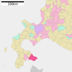
English: Location of Hakodate in Hokkaido Prefecture
日本語: 北海道函館市の位置
วันที่
(UTC)
แหล่งที่มา
ja:File:基礎自治体位置図 01202.svg
ผู้สร้างสรรค์
ja:User:Lincun
การอนุญาต (การใช้ไฟล์นี้ใหม่)
This file is a map of a municipality in Japan created and uploaded by Lincun on Japanese Wikipedia. It may also be a file based on one of these maps (see info in file history or author field for more info on later editors). Source:
English: Data used : Ministry of Land, Infrastructure, Transport and Tourism - National Land Numerical Information (Administrative Area (N03) / Lake (W09))
日本語: 使用データ : 国土交通省 国土数値情報(行政区域(N03)・湖沼(W09))
The original file was licensed {{GFDL}} and {{Cc-by-sa-3.0}}. See this category for more files like this. ป้ายนี้มิใช่ป้ายแสดงสถานะลิขสิทธิ์ ดังนั้นการระบุสถานะลิขสิทธิ์จึงต้องกระทำแยกต่างหาก ดูที่ Commons:Lincensing
ไฟล, hakodate, hokkaido, prefecture, ไฟล, ประว, ไฟล, หน, าท, ภาพน, การใช, ไฟล, วนกลาง, อม, ลเก, ยวก, บภาพขนาดของต, วอย, าง, ของไฟล, กเซล, ความละเอ, ยดอ, กเซล, กเซล, กเซล, กเซล, กเซล, ภาพท, ความละเอ, ยดส, งกว, 8206, ไฟล, กเซล, ขนาดไฟล, โลไบต, ปภาพหร, อไฟล, เส, . ifl prawtiifl hnathimiphaphni karichiflswnklang khxmulekiywkbphaphkhnadkhxngtwxyang PNG nikhxngifl SVG ni 600 600 phikesl khwamlaexiydxun 240 240 phikesl 480 480 phikesl 768 768 phikesl 1 024 1 024 phikesl 2 048 2 048 phikesl duphaphthimikhwamlaexiydsungkwa 8206 ifl SVG 800 800 phikesl khnadifl 104 kiolibt rupphaphhruxiflesiyngni tnchbbxyuthi khxmmxns raylaexiyddanlang epnkhxkhwamthiaesdngphlcak ifltnchbbinkhxmmxns khxmmxnsepnewbistinokhrngkarsahrbekbrwbrwmsuxesri thi khunsamarthchwyid khwamyx khaxthibayHakodate in Hokkaido Prefecture Ja svg English Location of Hakodate in Hokkaido Prefecture 日本語 北海道函館市の位置wnthi 9 phvscikayn ph s 2550 14 58 UTC aehlngthima ja File 基礎自治体位置図 01202 svgphusrangsrrkh ja User Lincunkarxnuyat karichiflniihm This file is a map of a municipality in Japan created and uploaded by Lincun on Japanese Wikipedia It may also be a file based on one of these maps see info in file history or author field for more info on later editors Source English Data used Ministry of Land Infrastructure Transport and Tourism National Land Numerical Information Administrative Area N03 Lake W09 日本語 使用データ 国土交通省 国土数値情報 行政区域 N03 湖沼 W09 The original file was licensed GFDL and Cc by sa 3 0 See this category for more files like this paynimiichpayaesdngsthanalikhsiththi dngnnkarrabusthanalikhsiththicungtxngkrathaaeyktanghak duthi Commons Lincensing karxnuyatichsiththi xnuyatihkhdlxk aeckcayaela hruxddaeprexksarniphayitenguxnikhkhxngsyyaxnuyatexksaresrikhxngknu run 1 2 hruxrunid nbcaknithixxkodymulnithisxftaewresri odyimmiswnidhamaekikh immikhxkhwampkhnaaelapkhlng saenakhxngsyyaxnuyatrwmxyuinswnchux syyaxnuyatexksaresrikhxngknuhttp www gnu org copyleft fdl html GFDL GNU Free Documentation License true trueiflnixyuphayitsyyaxnuyat khriexthifkhxmmxns aebbaesdngthima xnuyataebbediywkn 3 0 tnchbbkhunsamarth thicaaebngpn thicathasaena aeckcay aelasngngandngklawtxip thicaeriyberiyngihm thicaddaeplngngandngklaw phayitenguxnikhtxipni aesdngthima khuntxngihekiyrtiecakhxngnganxyangehmaasm odyephimlingkipyngsyyaxnuyat aelarabuhakmikarepliynaeplng khunxacthaechnniidinrupaebbidkidtamkhwr aettxngimichinlksnathiaenawaphuihxnuyatsnbsnunkhunhruxkarichngankhxngkhun xnuyataebbediywkn hakkhunddaeplng epliynrup hruxtxetimnganni khuntxngichsyyaxnuyataebbediywknhruxaebbthiehmuxnkbsyyaxnuyatthiichkbnganniethannhttps creativecommons org licenses by sa 3 0 CC BY SA 3 0 Creative Commons Attribution Share Alike 3 0 true truekhabrryayodyyxithyephimkhabrryaythrrthdediywephuxkhyaykhwamwaiflnimixairixethmthiaesdngxyuiniflniprakxbdwysthanalikhsiththimilikhsiththisyyaxnuyatCreative Commons Attribution ShareAlike 3 0 Unported xngkvsGNU Free Documentation License version 1 2 or later xngkvswnthisrang wnkxtng9 phvscikayn 2007 prawtiifl khlikwnthi ewlaephuxduiflthipraktinkhnann wnthi ewlarupyxkhnadphuichkhwamehn pccubn18 29 17 phvscikayn 2563800 800 104 kiolibt AichiWikiFixerUpdate 09 42 2 thnwakhm 2552531 493 5 kiolibt ASDFGHJupdate version 10 48 6 phvsphakhm 2552800 872 42 kiolibt Monaneko Information Description en 1 Location of Hakodate in Hokkaido Prefecture ja 1 北海道函館市の位置 Source ja File 基礎自治体位置図 01202 svg Author ja User Lincun Date 2007 11 09 14 58 UTC Permission GFDL other v hnathimiphaphni hnatxipni oyngmathiphaphni kingcnghwdoxchima hkikod haokdaeta karichiflswnklang wikixuntxipniichiflni karichbn ar wikipedia org هاكوداته هوكايدو karichbn arz wikipedia org هاكوداته karichbn ast wikipedia org Hakodate karichbn azb wikipedia org هاکوداته karichbn ca wikipedia org Hakodate karichbn ceb wikipedia org Hakodate lungsod sa Hapon karichbn ce wikipedia org Hakodate karichbn de wikipedia org Hakodate karichbn el wikipedia org Xakontate karichbn en wikipedia org Hokkaido Hakodate Oshima Subprefecture Core cities of Japan karichbn es wikipedia org Hakodate karichbn eu wikipedia org Hakodate Hokkaido karichbn fa wikipedia org هاکوداته karichbn fi wikipedia org Hakodate karichbn ga wikipedia org Hakodate karichbn gl wikipedia org Hakodate karichbn ko wikipedia org 하코다테시 karichbn nl wikipedia org Hakodate karichbn nn wikipedia org Hakodate karichbn pl wikipedia org Podprefektura Oshima karichbn ro wikipedia org Hakodate karichbn sco wikipedia org Hakodate Hokkaido karichbn simple wikipedia org Hakodate karichbn sr wikipedia org Hakodate karichbn tg wikipedia org Ҳakodate karichbn tt wikipedia org Hakodate karichbn uk wikipedia org Hakodate karichbn ur wikipedia org ہاکوداتے ہوکائیدو karichbn www wikidata org Q26418 karichbn zh min nan wikipedia org Hakodate chhi karichbn zh wikipedia org 函館市khxmulekiywkbphaph phaphnimikhxmulephimetim sungswnihymacakklxngdicitxlhruxsaeknenxrthisamarthekbkhxmuldngklawiwrwmkbphaphid thaphaphnithukprbprungaekikhhruxepliynaeplngcakedim khxmulbangxyangcayngkhngimepliynaeplngehmuxnphaphthithukprbprungaekikhnnchuxeruxngsn北海道函館市位置図chuxphaphAuthor Lincunkhwamkwang800khwamsung800 ekhathungcak https th wikipedia org wiki ifl Hakodate in Hokkaido Prefecture Ja svg, wikipedia, วิกิ หนังสือ, หนังสือ, ห้องสมุด,