คำอธิบายHistorical Map of Sikkim in northeastern India.jpg
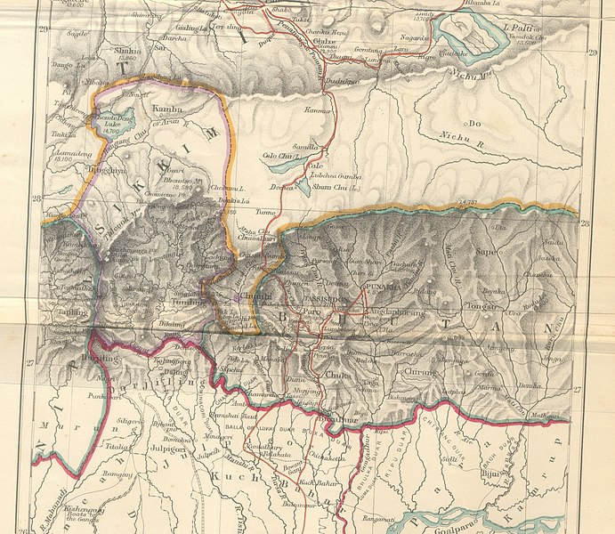
English: Historical Map of Sikkim in northeastern India extracted from map prepared by Trelawney Saunders, 1876, titled "The routes of Bogle, Turner and Manning between Bengal and Tibet" and published in the book, Narratives of the Mission of George Bogle to Tibet, and of the Journey of Thomas Manning to Lhasa, by Clements R. Markham, C.B., F.R.S. Geographical Department, India Office. Published by London: Trübner and Co., Ludgate Hill. 1876.
วันที่
แหล่งที่มา
The routes of Bogle, Turner and Manning between Bengal and Tibet. Narratives of the Mission of George Bogle to Tibet, and of the Journey of Thomas Manning to Lhasa, by Clements R. Markham
The original description page was here. All following user names refer to en.wikipedia.
2009-10-14 10:25 Hindutashravi 4510×3916× (15480075 bytes) Historical Map of Sikkim in northeastern India extracted from map prepared by Trelawney Saunders, 1876 titled The routes of Bogle, Turner and Manning between Bengal and Tibet, and published in the book Titled, Narratives of the Mission of George Bogle
{{BotMoveToCommons|en.wikipedia|year={{subst:CURRENTYEAR}}|month={{subst:CURRENTMONTHNAME}}|day={{subst:CURRENTDAY}}}} {{Information |Description={{en|Historical Map of Sikkim in northeastern India extracted from map prepared by Trelawney Saunders, 1876
ไฟล, historical, sikkim, northeastern, india, ไฟล, ประว, ไฟล, หน, าท, ภาพน, การใช, ไฟล, วนกลาง, อม, ลเก, ยวก, บภาพขนาดของต, วอย, างน, กเซล, ความละเอ, ยดอ, กเซล, กเซล, กเซล, กเซล, กเซล, กเซล, ภาพท, ความละเอ, ยดส, งกว, 8206, กเซล, ขนาดไฟล, เมกะไบต, ชน, ดไมม, ima. ifl prawtiifl hnathimiphaphni karichiflswnklang khxmulekiywkbphaphkhnadkhxngtwxyangni 691 600 phikesl khwamlaexiydxun 276 240 phikesl 553 480 phikesl 885 768 phikesl 1 179 1 024 phikesl 2 359 2 048 phikesl 4 510 3 916 phikesl duphaphthimikhwamlaexiydsungkwa 8206 4 510 3 916 phikesl khnadifl 14 76 emkaibt chnidimm image jpeg rupphaphhruxiflesiyngni tnchbbxyuthi khxmmxns raylaexiyddanlang epnkhxkhwamthiaesdngphlcak ifltnchbbinkhxmmxns khxmmxnsepnewbistinokhrngkarsahrbekbrwbrwmsuxesri thi khunsamarthchwyid khwamyx khaxthibayHistorical Map of Sikkim in northeastern India jpg English Historical Map of Sikkim in northeastern India extracted from map prepared by Trelawney Saunders 1876 titled The routes of Bogle Turner and Manning between Bengal and Tibet and published in the book Narratives of the Mission of George Bogle to Tibet and of the Journey of Thomas Manning to Lhasa by Clements R Markham C B F R S Geographical Department India Office Published by London Trubner and Co Ludgate Hill 1876 wnthi 2418 hrux 2419aehlngthima The routes of Bogle Turner and Manning between Bengal and Tibet Narratives of the Mission of George Bogle to Tibet and of the Journey of Thomas Manning to Lhasa by Clements R Markhamphusrang Trelawney Saunders Geotemporal datakhxbekht N 29 5500579 NW 87 3962325 E E 91 5280426 ES 25 9498257 Nphikdxangxingthangphumisastr duaephnthithixangxingthangphumisastrcak Wikimaps Warper karxnuyatichsiththi Public domain Public domain false falsephaphhruxsuxniepn satharnsmbti inshrthxemrikakhxkhwamtxipniichbngkhbaekphlngankhxngshrthxemrikathihmdxayukarkhumkhrxngthanglikhsiththiaelw sungodymakekidcakkarthiphaphhruxsuxnimi kartiphimphephyaephrkhrngaerk kxnwnthi 1 mkrakhm kh s 1928 ph s 2471 sahrbkhaxthibayephimetim duthi hnaniphaphaelasuxni xacimepnsatharnsmbti inpraethsxunnxkehnuxcakpraethsshrthxemrika odyechphaapraethshruxdinaednthiimidbngkhbich kdrayaewlakhumkhrxnglikhsiththithisnkwa sahrbphlngankhxngshrthxemrika echn aekhnada cinaephndinihy imrwmhxngkngaelamaeka eyxrmn emksiokaelaswitesxraelnd dngnnphuxphohldcaepntxngrabukhxmulekiywkbphusrangsrrkhphaphhruxsuxni aelapithisrangsrrkhdwy duephimthi satharnsmbtiinwikiphiediy aela likhsiththiinwikiphiediyphaphniepnphaphthiekidcakkarthasaenaphaphhruxsilpkrrmsxngmiti sungtwphaphtnchbbthithukthasannepnsatharnsmbtidwyehtuphltxipni Public domain Public domain false falsenganniepnsatharnsmbti inpraethstnkaenidaelapraethsxun thirayaewlakarkhumkhrxnglikhsiththinxykwa 70 pihlngcakphusrangsrrkhnganesiychiwit nxkcaknikhunxactxngephimpaysatharnsmbtiinshrthxemrika ephuxrabuwaehtuidngannicungepnsatharnsmbtiinshrthxemrika oprdthrabwabangpraethsmikhxkahnderuxngkarkhumkhrxnglikhsiththinankwa 70 pi echn emksiok 100 pi caemka 95 pi okhlxmebiy 80 pi kwetmalaaelasamw 75 pi phaphnixacimepnsatharnsmbtiinpraethsehlanisungimidbngkhbichkdrayaewlakhumkhrxnglikhsiththithisnkwa praethsoktdiwwrmirayaewlakhumkhrxnglikhsiththithwip 99 pi aelahxndurs 75 pi aetichkdrayaewlakhumkhrxnglikhsiththithisnkwa nganlikhsiththixackhyayipinphlnganthisrangkhunodychawfrngessthiesiychiwitinpraethsfrngesscakehtukarnsngkhramolkkhrngthisxng khxmulephimetim chawrsesiythithahnathiinaenwrbdantawnxxkinsngkhramolkkhrngthisxng hruxeriykxyanghnungwa sngkhramtxtankhwamrkchatixnyingihykhxngrsesiy aelakarphkfunphuesiyhaycakkarthukcxngcainshphaphosewiyt khxmulephimetim iflniidthukrabuwaimmikhxcakdphayitkdhmaylikhsiththi rwmthungsiththithiekiywkhxngaelathiiklekhiyngknhttps creativecommons org publicdomain mark 1 0 PDM Creative Commons Public Domain Mark 1 0 false false mulnithiwikiphiediymimummxngxyangepnthangkarinkrniniwa karthasaenaphaphhruxsilpkrrmsxngmitithiepnsatharnsmbti thuxwaphaphthiidcakkarthasaenaepnsatharnsmbti karxangphlngandngklawepnnganswnbukhkhlepnkarkhdtxaenwkhidekiywkbsatharnsmbti sahrbkhxmulephimetim duthi emuxidcaichpay PD Artkarthasaenakhxngphaphnisungepnsatharnsmbti thuxidwaphaphthiekidcakkarthasaenaepnsatharnsmbtiechnkn oprdthrabwakarnaphaphniipichxacthukcakdhruxhamichinekhtxanacsalkhxngthan thngnikhunkbkdhmaythxngthinthibngkhbichinphunthinn duephimthi karnaphaphhruxsilpkrrmsxngmitiipichbnthukkarxphohld The original description page was here All following user names refer to en wikipedia 2009 10 14 10 25 Hindutashravi 4510 3916 15480075 bytes Historical Map of Sikkim in northeastern India extracted from map prepared by Trelawney Saunders 1876 titled The routes of Bogle Turner and Manning between Bengal and Tibet and published in the book Titled Narratives of the Mission of George BoglekhabrryayodyyxithyephimkhabrryaythrrthdediywephuxkhyaykhwamwaiflnimixairixethmthiaesdngxyuiniflniprakxbdwyMIME type xngkvsimage jpeg prawtiifl khlikwnthi ewlaephuxduiflthipraktinkhnann wnthi ewlarupyxkhnadphuichkhwamehn pccubn14 38 25 mithunayn 25534 510 3 916 14 76 emkaibt File Upload Bot Magnus Manske BotMoveToCommons en wikipedia year subst CURRENTYEAR month subst CURRENTMONTHNAME day subst CURRENTDAY Information Description en Historical Map of Sikkim in northeastern India extracted from map prepared by Trelawney Saunders 1876 hnathimiphaphni hnatxipni oyngmathiphaphni rachxanackrsikkhim karichiflswnklang wikixuntxipniichiflni karichbn ar wikipedia org مملكة سيكيم karichbn as wikipedia org শ ল গ ড karichbn bn wikipedia org শ ল গ ড স ক ম র জ য karichbn de wikipedia org Benutzer Er nun wieder Doklam karichbn el wikipedia org Basileio toy Sikim karichbn en wikipedia org Sikkim Siliguri karichbn gu wikipedia org સ ક ક મ karichbn he wikipedia org גיפמוצ י karichbn hi wikipedia org स क क म अध र ज य कलकत त क सम म लन karichbn id wikipedia org Kerajaan Sikkim karichbn ja wikipedia org シッキム王国 karichbn kn wikipedia org ಶ ಲ ಗ ಡ karichbn my wikipedia org ဆစ ကင ပ ည နယ karichbn nl wikipedia org Koninkrijk Sikkim karichbn pt wikipedia org Reino de Siquim karichbn sa wikipedia org श ल ग ड karichbn ta wikipedia org ச க க ம இர ச ச யம karichbn vi wikipedia org Vương quốc Sikkim karichbn www wikidata org Q3960459khxmulekiywkbphaph phaphnimikhxmulephimetim sungswnihymacakklxngdicitxlhruxsaeknenxrthisamarthekbkhxmuldngklawiwrwmkbphaphid thaphaphnithukprbprungaekikhhruxepliynaeplngcakedim khxmulbangxyangcayngkhngimepliynaeplngehmuxnphaphthithukprbprungaekikhnnphuphlitklxngHPrunkhxngklxngHP ScanJet 2400khwamlaexiydaenwnxn600 dpikhwamlaexiydaenwtng600 dpitaaehnng Y aela CCo sitedrunexksif Exif 2 2sepssisRGB ekhathungcak https th wikipedia org wiki ifl Historical Map of Sikkim in northeastern India jpg, wikipedia, วิกิ หนังสือ, หนังสือ, ห้องสมุด,