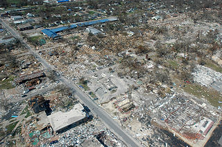
Long Beach, Mississippi, September 6, 2005 -- Destroyed businesses and municipal buildings on Jeff Davis Avenue in Long Beach, Mississippi from Hurricane Katrina (Long Beach is west of Gulfport and east of Pass Christian.) This photo shows the street at an angle but Jeff Davis actually runs North (upper left edge of the picture) to South (lower right) with the South part of the street at the photo's edge being approximately 200 yards from the Gulf of Mexico to approximately half-a-mile from the Gulf on the North end. The long, blue building is Harper McCaughan Elementary School, which appears to be shifted off of its foundation. To the north of that is Long Beach Public Library, with Long Beach City Hall to the north of the library. Although these building appear to be standing, upon closer inspection, they were heavily damaged and most had to be destroyed and re-built or re-located. The East-West streets showing are (going north) 5th Street, 4th St., and 3rd St. (the school and library intersection), 2nd St., then a little of the railroad tracks. There used to be as many houses on 4th and 5th streets as on 3rd St. and all the roads used to have a heavy cover of trees. The debris piles do not show very much in this photo because a lot of debris had been cleared from the area during the week between when the storm hit and this photo was taken, but the water-line debris piles created by the storm surge were at least 10-15 feet high in places (the debris line is more noticeable if you look at the roofs of the buildings.) Many of the businesses never came back but the City of Long Beach has done a very nice job of rebuilding the street much nicer than it was before.
The area in this photo is a fairly low-lying area. Hurricane Katrina caused extensive damage all along the Mississippi Gulf Coast with Waveland, Mississippi taking the strongest hit of the entire storm as it was right along the Northeast edge of the eye wall where the strongest winds of a hurricane reside.
From a long-time Beach resident... (edit by K. Dubuisson on 8/30/2011 not completed due to time constraint)
The section of Long Beach north of the railroad tracks is making a very speedy recovery, thanks to the diligence of City workers and all of the many volunteers in the area. The outpouring of support from all over the country has been incredible and greatly appreciated.
The section of Long Beach south of the tracks is a different story, although debris removal is coming along and a very few people have moved back into their homes. All (but one) of the people on Highway 90 lost their homes completely (gone with no trace), almost all on 5th and 4th streets have lost their homes completely, and most of the homes on 2nd and 3rd streets are heavily damaged, either by wind or by water. Most did not have flood insurance, except on Highway 90.
Some of us are having to get structural engineers to tell us whether or not it is feasible to repair our home or better to tear it down and start over. People have also hired structural engineers to try to prove that the wind took their home before the tidal surge brought all of the damaging water. If they can prove the wind took it, then their homeowner's insurance should pay. Otherwise ... FEMA is supposed to help with either low interest loans or grants. Most of us have not gone that far yet. Everything is still up-in-the-air (Oct 15, 2005), even after all of this time. (Volunteer structural engineers would be a blessing!)
Source
Photo courtesy FEMA/Mark Wolfe
This image is from the (obsolete as of 2019). An archived copy may be found at the (note: link may be permanently dead, as not all photos were backed up in this way). If the FEMA link is permanently dead, the photo can be found at NARA Access to Archival Databases (only works if photo was taken between 1989 and October 2004).
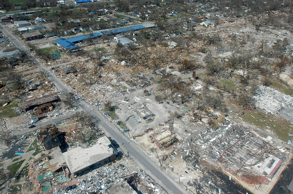
{{PD-USGov}} http://www.photolibrary.fema.gov/photodata/original/14801.jpg Gulfport, Miss., September 6, 2005 -- Destroyed houses in Gulfport, Miss. Hurricane Katrina caused extensive damage all along the Mississippi gulf coast. New Orleans is being eva
Gulfport, Miss., September 6, 2005 -- Destroyed houses in Gulfport, Miss. Hurricane Katrina caused extensive damage all along the Mississippi gulf coast. FEMA/Mark Wolfe
ผู้ผลิตกล้อง
NIKON CORPORATION
รุ่นของกล้อง
NIKON D70
ผู้ถ่าย
Mark Wolfe
เวลาเปิดหน้ากล้อง
1/400 วินาที (0.0025)
ค่าเอฟ
f/10
เวลาที่บันทึกภาพ
16:05, 6 กันยายน 2548
ความยาวโฟกัสเลนส์
17 มม.
การจัดวางภาพ
ปกติ
ความละเอียดแนวนอน
300 dpi
ความละเอียดแนวตั้ง
300 dpi
ซอฟต์แวร์ที่ใช้
Adobe Photoshop CS Windows
แก้ไขภาพล่าสุด
17:55, 6 กันยายน 2548
ตำแหน่ง Y และ C
Co-sited
โปรแกรมเอกซ์โพเชอร์
โปรแกรมปกติ
รุ่นเอกซิฟ (Exif)
2.21
เวลาที่แปลงเป็นดิจิทัล
16:05, 6 กันยายน 2548
โหมดการบีบอัดภาพ
4
การชดเชยแสง
0
รูรับแสงกว้างสุด
3 APEX (f/2.83)
โหมดการวัดแสง
แพตเทิร์น
แสง
ไม่ทราบ
แฟลช
ไม่ใช้แฟลช
เสี้ยววินาที วันที่ เวลา
90
เสี้ยววินาที วันที่ เวลาต้นฉบับ
90
เสี้ยววินาที วันที่ เวลาที่ดิจิไทซ์
90
สเปซสี
sRGB
วิถีการวัด
เซนเซอร์จุดเดียว
การประมวลภาพ
โพลเซสส์ปกติ
โหมดเอกซ์โพเชอร์
เอกซ์โพเชอร์อัตโนมัติ
ไวต์บาลานซ์
ไวต์บาลานซ์อัตโนมัติ
ดิจิทัลซูม
1
ระยะโฟกัสในฟิล์ม 35 มม.
25 มม.
ชนิดซีนแคปเจอร์
ปกติ
ความเปรีบบต่าง
ปกติ
ความอิ่มสี
ปกติ
ความคม
ปกติ
ระยะห่างวัตถุ
ไม่ทราบ
กุมภาพันธ์ 16, 2023
ไฟล, hurricane, katrina, damage, gulfport, mississippi, ไฟล, ประว, ไฟล, หน, าท, ภาพน, การใช, ไฟล, วนกลาง, อม, ลเก, ยวก, บภาพขนาดของต, วอย, างน, กเซล, ความละเอ, ยดอ, กเซล, กเซล, กเซล, กเซล, กเซล, ภาพท, ความละเอ, ยดส, งกว, 8206, กเซล, ขนาดไฟล, เมกะไบต, ชน, ดไมม,. ifl prawtiifl hnathimiphaphni karichiflswnklang khxmulekiywkbphaphkhnadkhxngtwxyangni 800 532 phikesl khwamlaexiydxun 320 213 phikesl 640 426 phikesl 1 024 681 phikesl 1 280 851 phikesl 3 008 2 000 phikesl duphaphthimikhwamlaexiydsungkwa 8206 3 008 2 000 phikesl khnadifl 2 64 emkaibt chnidimm image jpeg rupphaphhruxiflesiyngni tnchbbxyuthi khxmmxns raylaexiyddanlang epnkhxkhwamthiaesdngphlcak ifltnchbbinkhxmmxns khxmmxnsepnewbistinokhrngkarsahrbekbrwbrwmsuxesri thi khunsamarthchwyid khwamyx Long Beach Mississippi September 6 2005 Destroyed businesses and municipal buildings on Jeff Davis Avenue in Long Beach Mississippi from Hurricane Katrina Long Beach is west of Gulfport and east of Pass Christian This photo shows the street at an angle but Jeff Davis actually runs North upper left edge of the picture to South lower right with the South part of the street at the photo s edge being approximately 200 yards from the Gulf of Mexico to approximately half a mile from the Gulf on the North end The long blue building is Harper McCaughan Elementary School which appears to be shifted off of its foundation To the north of that is Long Beach Public Library with Long Beach City Hall to the north of the library Although these building appear to be standing upon closer inspection they were heavily damaged and most had to be destroyed and re built or re located The East West streets showing are going north 5th Street 4th St and 3rd St the school and library intersection 2nd St then a little of the railroad tracks There used to be as many houses on 4th and 5th streets as on 3rd St and all the roads used to have a heavy cover of trees The debris piles do not show very much in this photo because a lot of debris had been cleared from the area during the week between when the storm hit and this photo was taken but the water line debris piles created by the storm surge were at least 10 15 feet high in places the debris line is more noticeable if you look at the roofs of the buildings Many of the businesses never came back but the City of Long Beach has done a very nice job of rebuilding the street much nicer than it was before The area in this photo is a fairly low lying area Hurricane Katrina caused extensive damage all along the Mississippi Gulf Coast with Waveland Mississippi taking the strongest hit of the entire storm as it was right along the Northeast edge of the eye wall where the strongest winds of a hurricane reside From a long time Beach resident edit by K Dubuisson on 8 30 2011 not completed due to time constraint The section of Long Beach north of the railroad tracks is making a very speedy recovery thanks to the diligence of City workers and all of the many volunteers in the area The outpouring of support from all over the country has been incredible and greatly appreciated The section of Long Beach south of the tracks is a different story although debris removal is coming along and a very few people have moved back into their homes All but one of the people on Highway 90 lost their homes completely gone with no trace almost all on 5th and 4th streets have lost their homes completely and most of the homes on 2nd and 3rd streets are heavily damaged either by wind or by water Most did not have flood insurance except on Highway 90 Some of us are having to get structural engineers to tell us whether or not it is feasible to repair our home or better to tear it down and start over People have also hired structural engineers to try to prove that the wind took their home before the tidal surge brought all of the damaging water If they can prove the wind took it then their homeowner s insurance should pay Otherwise FEMA is supposed to help with either low interest loans or grants Most of us have not gone that far yet Everything is still up in the air Oct 15 2005 even after all of this time Volunteer structural engineers would be a blessing Source Photo courtesy FEMA Mark WolfeThis image is from the FEMA Photo Library obsolete as of 2019 An archived copy may be found at the Wayback Machine note link may be permanently dead as not all photos were backed up in this way If the FEMA link is permanently dead the photo can be found at NARA Access to Archival Databases only works if photo was taken between 1989 and October 2004 karxnuyatichsiththi Public domain Public domain false false This image is a work of a Federal Emergency Management Agency employee taken or made as part of that person s official duties As works of the U S federal government all FEMA images are in the public domain in the United States Additional media usage information may be found at https www fema gov photo video audio use guidelines cestina nbsp English nbsp eesti nbsp italiano nbsp makedonski nbsp മലയ ള nbsp Nederlands nbsp polski nbsp sicilianu nbsp Turkce nbsp ukrayinska nbsp 中文 nbsp 中文 简体 nbsp 中文 繁體 nbsp prawtiifl khlikwnthi ewlaephuxduiflthipraktinkhnann wnthi ewlarupyxkhnadphuichkhwamehn pccubn10 42 7 knyayn 25483 008 2 000 2 64 emkaibt Tom PD USGov http www photolibrary fema gov photodata original 14801 jpg Gulfport Miss September 6 2005 Destroyed houses in Gulfport Miss Hurricane Katrina caused extensive damage all along the Mississippi gulf coast New Orleans is being eva hnathimiphaphni hnatxipni oyngmathiphaphni phayuhmunekhtrxn karichiflswnklang wikixuntxipniichiflni karichbn ar wikipedia org 2005 أكتواري karichbn ast wikipedia org Ciclon tropical Furacan Katrina karichbn bn wikipedia org ব ম গ ণন ক karichbn de wiktionary org Zerstorung karichbn el wikipedia org Analogisths karichbn en wikipedia org Geography of the United States Actuary Hurricane Katrina Wikipedia Today s featured article September 10 2006 Hurricane Katrina effects by region Effects of Hurricane Katrina in Mississippi Tropical cyclone preparedness Portal Tropical cyclones Wikipedia Today s featured article September 2006 Effects of tropical cyclones User Alex1996Ne Neat Pictures User E Brown Hurricane Hall of Fame continued List of costliest Atlantic hurricanes Portal Business Selected article Portal Business Selected article 6 karichbn en wikiversity org Hurricane karichbn es wikipedia org Ciclon tropical Huracan Katrina The Last of Us karichbn es wikinews org Categoria Ciclones tropicales karichbn he wikipedia org גאוגרפיה של ארצות הברית karichbn hi wikipedia org उष णकट ब ध य चक रव त karichbn hr wikipedia org Tropska oluja Ciklona Orkan karichbn ia wikipedia org Cyclon tropic karichbn id wikipedia org Aktuaris karichbn it wikipedia org Uragano Katrina karichbn ja wikipedia org アメリカ合衆国の地理 karichbn kk wikipedia org Aktuarij karichbn kn wikipedia org ಕತ ರ ನ ಚ ಡಮ ರ ತ ಉಷ ಣವಲಯದ ಚ ಡಮ ರ ತಗಳ ಪರ ಣ ಮಗಳ karichbn kw wikipedia org Trowyns trovannel karichbn li wiktionary org verinnewering karichbn lv wikipedia org Viesulvetra Aktuars karichbn mn wikipedia org Hereglegch Tsogo3 Noorog Үndsen ogүүllegees Tropikijn ciklon Haluun orny huj salhi karichbn ms wikipedia org Taufan Aktuari karichbn mwl wikipedia org Ciclone tropical karichbn nl wikibooks org Wikijunior Aardrijkskunde Wind Wikijunior Aardrijkskunde Bibliotheek dukarichthwolkephimetimkhxngiflnikhxmulekiywkbphaph phaphnimikhxmulephimetim sungswnihymacakklxngdicitxlhruxsaeknenxrthisamarthekbkhxmuldngklawiwrwmkbphaphid thaphaphnithukprbprungaekikhhruxepliynaeplngcakedim khxmulbangxyangcayngkhngimepliynaeplngehmuxnphaphthithukprbprungaekikhnnchuxphaphGulfport Miss September 6 2005 Destroyed houses in Gulfport Miss Hurricane Katrina caused extensive damage all along the Mississippi gulf coast FEMA Mark WolfephuphlitklxngNIKON CORPORATIONrunkhxngklxngNIKON D70phuthayMark Wolfeewlaepidhnaklxng1 400 winathi 0 0025 khaexff 10ewlathibnthukphaph16 05 6 knyayn 2548khwamyawofkselns17 mm karcdwangphaphpktikhwamlaexiydaenwnxn300 dpikhwamlaexiydaenwtng300 dpisxftaewrthiichAdobe Photoshop CS Windowsaekikhphaphlasud17 55 6 knyayn 2548taaehnng Y aela CCo sitedopraekrmexksophechxropraekrmpktirunexksif Exif 2 21ewlathiaeplngepndicithl16 05 6 knyayn 2548ohmdkarbibxdphaph4karchdechyaesng0rurbaesngkwangsud3 APEX f 2 83 ohmdkarwdaesngaephtethirnaesngimthrabaeflchimichaeflchesiywwinathi wnthi ewla90esiywwinathi wnthi ewlatnchbb90esiywwinathi wnthi ewlathidiciiths90sepssisRGBwithikarwdesnesxrcudediywkarpramwlphaphophlessspktiohmdexksophechxrexksophechxrxtonmtiiwtbalansiwtbalansxtonmtidicithlsum1rayaofksinfilm 35 mm 25 mm chnidsinaekhpecxrpktikhwamepribbtangpktikhwamximsipktikhwamkhmpktirayahangwtthuimthrab ekhathungcak https th wikipedia org wiki ifl Hurricane katrina damage gulfport mississippi jpg, wikipedia, วิกิ หนังสือ, หนังสือ, ห้องสมุด,