The factual accuracy of this map or the file name is disputed.
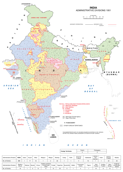
Reason: This map, which shows administrative divisions of India in 1951, makes some big mistakes. First, this map shows Sikkim as a part of India. Sikkim was a sovereign state from 1642 to 1975; Sikkim is a state of India from 1975. Thus, this map should show Sikkim as a sovereign state as same as China, Afghanistan, Nepal, Bhutan, Pakistan, Myanmar and Sri Lanka near India. Second, this map shows Bangladesh as a sovereign state. East Pakistan was a part of Pakistan from 14 August 1947, when Pakistan became independent from British India, to 16 December 1971, when Pakistan officially recognized the independence of Bangladesh. Thus, this map should change Bangladesh into East Pakistan, and show East Pakistan as a part of Pakistan.
Datasource (reference to visualized facts) is not provided for the data that is visualized in this self-made work.
ความย่อ
คำอธิบายIndia Administrative Divisions 1951.svg
English: India Administrative Divisions in 1951.
วันที่
แหล่งที่มา
งานของตัว
ผู้สร้างสรรค์
Andhrapur
ไฟล์นี้มีให้ใช้ภายใต้ CC0 1.0 Universal Public Domain Dedication ของครีเอทีฟคอมมอนส์
The person who associated a work with this deed has dedicated the work to the public domain by waiving all of their rights to the work worldwide under copyright law, including all related and neighboring rights, to the extent allowed by law. You can copy, modify, distribute and perform the work, even for commercial purposes, all without asking permission.
http://creativecommons.org/publicdomain/zero/1.0/deed.enCC0Creative Commons Zero, Public Domain Dedicationfalsefalse
ไฟล, india, administrative, divisions, 1951, ไฟล, ประว, ไฟล, หน, าท, ภาพน, การใช, ไฟล, วนกลางขนาดของต, วอย, าง, ของไฟล, กเซล, ความละเอ, ยดอ, กเซล, กเซล, กเซล, กเซล, กเซล, กเซล, ภาพท, ความละเอ, ยดส, งกว, 8206, ไฟล, กเซล, ขนาดไฟล, เมกะไบต, ปภาพหร, อไฟล, เส, ยงน,. ifl prawtiifl hnathimiphaphni karichiflswnklangkhnadkhxngtwxyang PNG nikhxngifl SVG ni 429 599 phikesl khwamlaexiydxun 172 240 phikesl 344 480 phikesl 550 768 phikesl 733 1 024 phikesl 1 467 2 048 phikesl 851 1 188 phikesl duphaphthimikhwamlaexiydsungkwa 8206 ifl SVG 851 1 188 phikesl khnadifl 1 86 emkaibt rupphaphhruxiflesiyngni tnchbbxyuthi khxmmxns raylaexiyddanlang epnkhxkhwamthiaesdngphlcak ifltnchbbinkhxmmxns khxmmxnsepnewbistinokhrngkarsahrbekbrwbrwmsuxesri thi khunsamarthchwyid The factual accuracy of this map or the file name is disputed Reason This map which shows administrative divisions of India in 1951 makes some big mistakes First this map shows Sikkim as a part of India Sikkim was a sovereign state from 1642 to 1975 Sikkim is a state of India from 1975 Thus this map should show Sikkim as a sovereign state as same as China Afghanistan Nepal Bhutan Pakistan Myanmar and Sri Lanka near India Second this map shows Bangladesh as a sovereign state East Pakistan was a part of Pakistan from 14 August 1947 when Pakistan became independent from British India to 16 December 1971 when Pakistan officially recognized the independence of Bangladesh Thus this map should change Bangladesh into East Pakistan and show East Pakistan as a part of Pakistan Datasource reference to visualized facts is not provided for the data that is visualized in this self made work khwamyx khaxthibayIndia Administrative Divisions 1951 svg English India Administrative Divisions in 1951 wnthi 9 singhakhm ph s 2555aehlngthima ngankhxngtwphusrangsrrkh Andhrapur iflnimiihichphayit CC0 1 0 Universal Public Domain Dedication khxngkhriexthifkhxmmxnsThe person who associated a work with this deed has dedicated the work to the public domain by waiving all of their rights to the work worldwide under copyright law including all related and neighboring rights to the extent allowed by law You can copy modify distribute and perform the work even for commercial purposes all without asking permission http creativecommons org publicdomain zero 1 0 deed en CC0 Creative Commons Zero Public Domain Dedication false falsekhabrryayodyyxithyephimkhabrryaythrrthdediywephuxkhyaykhwamwaiflnimixairbngklaভ রত র র জন ত ক ম নচ ত র ১৯৫১hindiMap of administrative divisions of India in 1967ixethmthiaesdngxyuiniflniprakxbdwyphusrangbangkhathiimmiixethmwikisnethschuxphusrangsrrkh Andhrapurchuxphuichwikimiediy Andhrapursthanalikhsiththicopyrighted dedicated to the public domain by copyright holder xngkvssyyaxnuyatCC0 xngkvswnthisrang wnkxtng9 singhakhm 2012thimakhxngiflkarsrangdngedimodyphuxpohldMIME type xngkvsimage svg xml prawtiifl khlikwnthi ewlaephuxduiflthipraktinkhnann wnthi ewlarupyxkhnadphuichkhwamehn pccubn20 34 9 singhakhm 2555851 1 188 1 86 emkaibt AndhrapurMade some corrections 20 28 9 singhakhm 2555765 990 1 86 emkaibt AndhrapurSmaller size 19 51 9 singhakhm 2555905 1 254 2 45 emkaibt Andhrapur subst Upload marker added by en wp UW Information Description en India Administrative Divisions in 1951 Source own Date 2012 08 09 Author Andhrapur cc zero hnathimiphaphni hnatxipni oyngmathiphaphni praethsxinediyinekhruxckrphph karichiflswnklang wikixuntxipniichiflni karichbn ar wikipedia org اتحاد الهند karichbn ast wikipedia org Estaos y territorios de la India karichbn be tarask wikipedia org Indyya karichbn bn wikipedia org ভ রত র র জ য ও ক ন দ রশ স ত অঞ চলসম হ ভ রত র প রস ত ব ত র জ য ও ক ন দ রশ স ত অঞ চল ভ রত র র জন ত ক একত র করণ র জ য প নর গঠন আইন ১৯৫৬ মহ গ জর ত আন দ লন প র ব প ঞ জ ব karichbn ce wikipedia org HӀindi karichbn cs wikipedia org Dominium Indie karichbn el wikipedia org Proteinomenes politeies ths Indias Dioikhtiko systhma ths Indias karichbn en wikipedia org States and union territories of India East Punjab States Reorganisation Commission 1952 West Bengal Legislative Assembly election 1952 Madras Legislative Assembly election Union territory History of Bellary Mahagujarat movement States Reorganisation Act 1956 1952 Coorg Legislative Assembly election 1952 Ajmer Legislative Assembly election 1952 Hyderabad Legislative Assembly election 1952 Delhi Legislative Assembly election 1952 Assam Legislative Assembly election 1952 Orissa Legislative Assembly election 1952 Bhopal Legislative Assembly election List of members of the 1st Lok Sabha 1954 Travancore Cochin Legislative Assembly election 1952 Patiala and East Punjab States Union Legislative Assembly election 1952 Travancore Cochin Legislative Assembly election 1952 Bombay Legislative Assembly election 1952 Madhya Bharat Legislative Assembly election 1952 Madhya Pradesh Legislative Assembly election 1952 Mysore Legislative Assembly election 1952 Punjab Legislative Assembly election 1952 Rajasthan Legislative Assembly election 1952 Saurashtra Legislative Assembly election 1952 Vindhya Pradesh Legislative Assembly election 1952 Uttar Pradesh Legislative Assembly election Wikipedia Reference desk Archives Humanities 2018 July 27 1967 Assam Legislative Assembly election karichbn en wikibooks org Constitution of India Union and territory karichbn es wikipedia org Anexo Propuestas de nuevas subdivisiones de la India karichbn eu wikipedia org Indiako Agindupeko Lurra karichbn fi wikipedia org Intian dominio karichbn fr wikipedia org Etats et territoires de l Inde karichbn gu wikipedia org ભ રતન ર જ ય અન ક ન દ રશ સ ત પ રદ શ dukarichthwolkephimetimkhxngiflni ekhathungcak https th wikipedia org wiki ifl India Administrative Divisions 1951 svg, wikipedia, วิกิ หนังสือ, หนังสือ, ห้องสมุด,