ดูภาพที่มีความละเอียดสูงกว่า (1,443 × 1,443 พิกเซล, ขนาดไฟล์: 529 กิโลไบต์, ชนิดไมม์: image/png)
ความย่อ
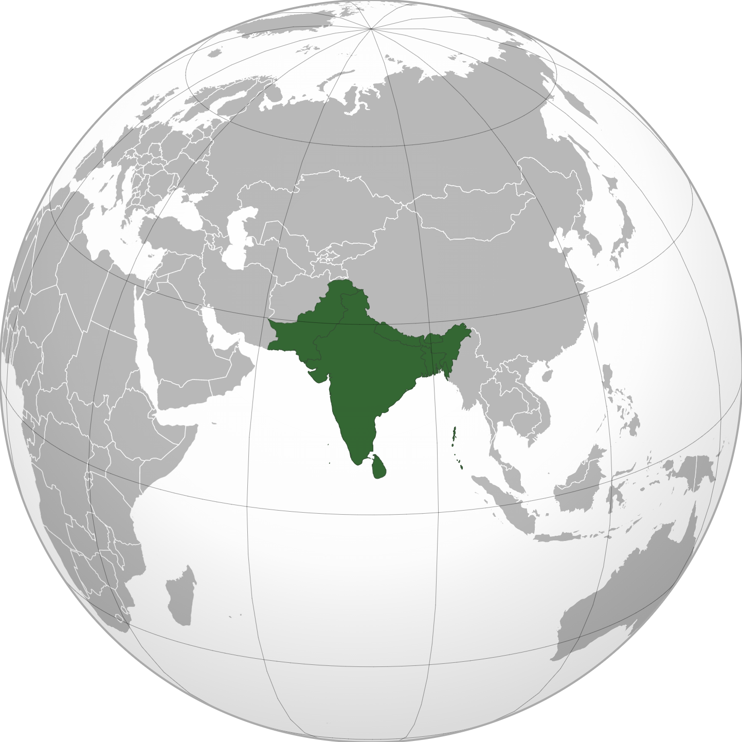
| คำอธิบายIndian Subcontinent (orthographic projection).png | English: Grey-green orthographic projection focused on the Indian Subcontinent, where all countries part of said Indian Subcontinent are highlighted dark green to provide the viewer with a visual representation of where the Indian Subcontinent is and what countries are part of it. | ||
| วันที่ | |||
| แหล่งที่มา |
| ||
| ผู้สร้างสรรค์ | User:Zeex.rice | ||
| เวอร์ชันอื่น | This is a Grey & green orthographic projection map.
العربية: الرجاء، قراءة الميثاق. বাংলা: দয়া করে, রীতিনীতিটি পড়ুন। Deutsch: Bitte lies die Konventionen. English: Please, read the conventions. Español: Por favor, lea las convenciones. Filipino: Paki-basa ang mga kumbensyon. Français : S'il vous plaît, lisez les conventions. हिन्दी: कृपया सभागमों को पढ़ लें. Bahasa Indonesia: Silakan, baca konvensi. Italiano: Si prega di leggere le convenzioni. 日本語: 規約をご確認ください。 ქართული: გთხოვთ, გაეცნოთ კონვენციებს. Македонски: Ве молиме, прочитајте ги општоприфатените правила. Português: Por favor, leia as convenções. Русский: Пожалуйста, прочитайте соглашения. Tagalog: Paki-basa ang mga kumbensyon. Українська: Будь ласка, прочитайте конвенції. Tiếng Việt: Hãy đọc công văn trước khi đăng.
| ||
| PNG genesis InfoField | ไฟล์PNG ภาพกราฟิกส์เวกเตอร์นี้ สร้างขึ้นโดยใช้ Inkscape, or with something else.
|
การอนุญาตใช้สิทธิ
- คุณสามารถ:
- ที่จะแบ่งปัน – ที่จะทำสำเนา แจกจ่าย และส่งงานดังกล่าวต่อไป
- ที่จะเรียบเรียงใหม่ – ที่จะดัดแปลงงานดังกล่าว
- ภายใต้เงื่อนไขต่อไปนี้:
- แสดงที่มา – คุณต้องให้เกียรติเจ้าของงานอย่างเหมาะสม โดยเพิ่มลิงก์ไปยังสัญญาอนุญาต และระบุหากมีการเปลี่ยนแปลง คุณอาจทำเช่นนี้ได้ในรูปแบบใดก็ได้ตามควร แต่ต้องไม่ใช่ในลักษณะที่แนะว่าผู้ให้อนุญาตสนับสนุนคุณหรือการใช้งานของคุณ
- อนุญาตแบบเดียวกัน – หากคุณดัดแปลง เปลี่ยนรูป หรือต่อเติมงานนี้ คุณต้องใช้สัญญาอนุญาตแบบเดียวกันหรือแบบที่เหมือนกับสัญญาอนุญาตที่ใช้กับงานนี้เท่านั้น
| อนุญาตให้คัดลอก แจกจ่ายและ/หรือดัดแปรเอกสารนี้ภายใต้เงื่อนไขของสัญญาอนุญาตเอกสารเสรีของกนู รุ่น 1.2 หรือรุ่นใด ๆ นับจากนี้ที่ออกโดยมูลนิธิซอฟต์แวร์เสรี โดยไม่มีส่วนใดห้ามแก้ไข ไม่มีข้อความปกหน้าและปกหลัง สำเนาของสัญญาอนุญาตรวมอยู่ในส่วนชื่อ สัญญาอนุญาตเอกสารเสรีของกนูhttp://www.gnu.org/copyleft/fdl.htmlGFDLGNU Free Documentation Licensetruetrue |
| อนุญาตให้คัดลอก แจกจ่ายและ/หรือดัดแปรเอกสารนี้ภายใต้เงื่อนไขของสัญญาอนุญาตเอกสารเสรีของกนู รุ่น 1.2 หรือรุ่นใด ๆ นับจากนี้ที่ออกโดยมูลนิธิซอฟต์แวร์เสรี โดยไม่มีส่วนใดห้ามแก้ไข ไม่มีข้อความปกหน้าและปกหลัง สำเนาของสัญญาอนุญาตรวมอยู่ในส่วนชื่อ สัญญาอนุญาตเอกสารเสรีของกนูhttp://www.gnu.org/copyleft/fdl.htmlGFDLGNU Free Documentation Licensetruetrue |
The map has been created with the Generic Mapping Tools: https://www.generic-mapping-tools.org/ using one or more of these public-domain datasets for the relief:
বাংলা ∙ English ∙ español ∙ français ∙ italiano ∙ 日本語 ∙ македонски ∙ sicilianu ∙ 中文(简体) ∙ 中文(繁體) ∙ +/− |
| อนุญาตให้คัดลอก แจกจ่ายและ/หรือดัดแปรเอกสารนี้ภายใต้เงื่อนไขของสัญญาอนุญาตเอกสารเสรีของกนู รุ่น 1.2 หรือรุ่นใด ๆ นับจากนี้ที่ออกโดยมูลนิธิซอฟต์แวร์เสรี โดยไม่มีส่วนใดห้ามแก้ไข ไม่มีข้อความปกหน้าและปกหลัง สำเนาของสัญญาอนุญาตรวมอยู่ในส่วนชื่อ สัญญาอนุญาตเอกสารเสรีของกนูhttp://www.gnu.org/copyleft/fdl.htmlGFDLGNU Free Documentation Licensetruetrue |
คำบรรยายโดยย่อ
ไอเทมที่แสดงอยู่ในไฟล์นี้
ประกอบด้วย
ประเทศอินเดีย
ประเทศปากีสถาน
ประเทศบังกลาเทศ
ประเทศศรีลังกา
ประเทศเนปาล
ประเทศภูฏาน
ประเทศมัลดีฟส์
สถานะลิขสิทธิ์
มีลิขสิทธิ์
สัญญาอนุญาต
Creative Commons Attribution-ShareAlike 3.0 Unported อังกฤษ
GNU Free Documentation License, version 1.2 or later อังกฤษ
วันที่สร้าง/วันก่อตั้ง
3 ตุลาคม 2020
ประวัติไฟล์
คลิกวันที่/เวลาเพื่อดูไฟล์ที่ปรากฏในขณะนั้น
| วันที่/เวลา | รูปย่อ | ขนาด | ผู้ใช้ | ความเห็น | |
|---|---|---|---|---|---|
| ปัจจุบัน | 00:29, 11 พฤศจิกายน 2565 | 1,443 × 1,443 (529 กิโลไบต์) | Sourav Bapuli | Added border for South Sudan as requested by {{u|Maphobbyist}} | |
| 13:59, 3 ตุลาคม 2563 | 551 × 551 (143 กิโลไบต์) | Zeex.rice | Uploaded a work by https://commons.wikimedia.org/wiki/User:Serg!o from https://en.wikipedia.org/wiki/File:South_Asia_(orthographic_projection)_without_national_boundaries.svg with UploadWizard |
หน้าที่มีภาพนี้
ไม่มีหน้าใดโยงมาที่ภาพนี้
การใช้ไฟล์ส่วนกลาง
วิกิอื่นต่อไปนี้ใช้ไฟล์นี้: