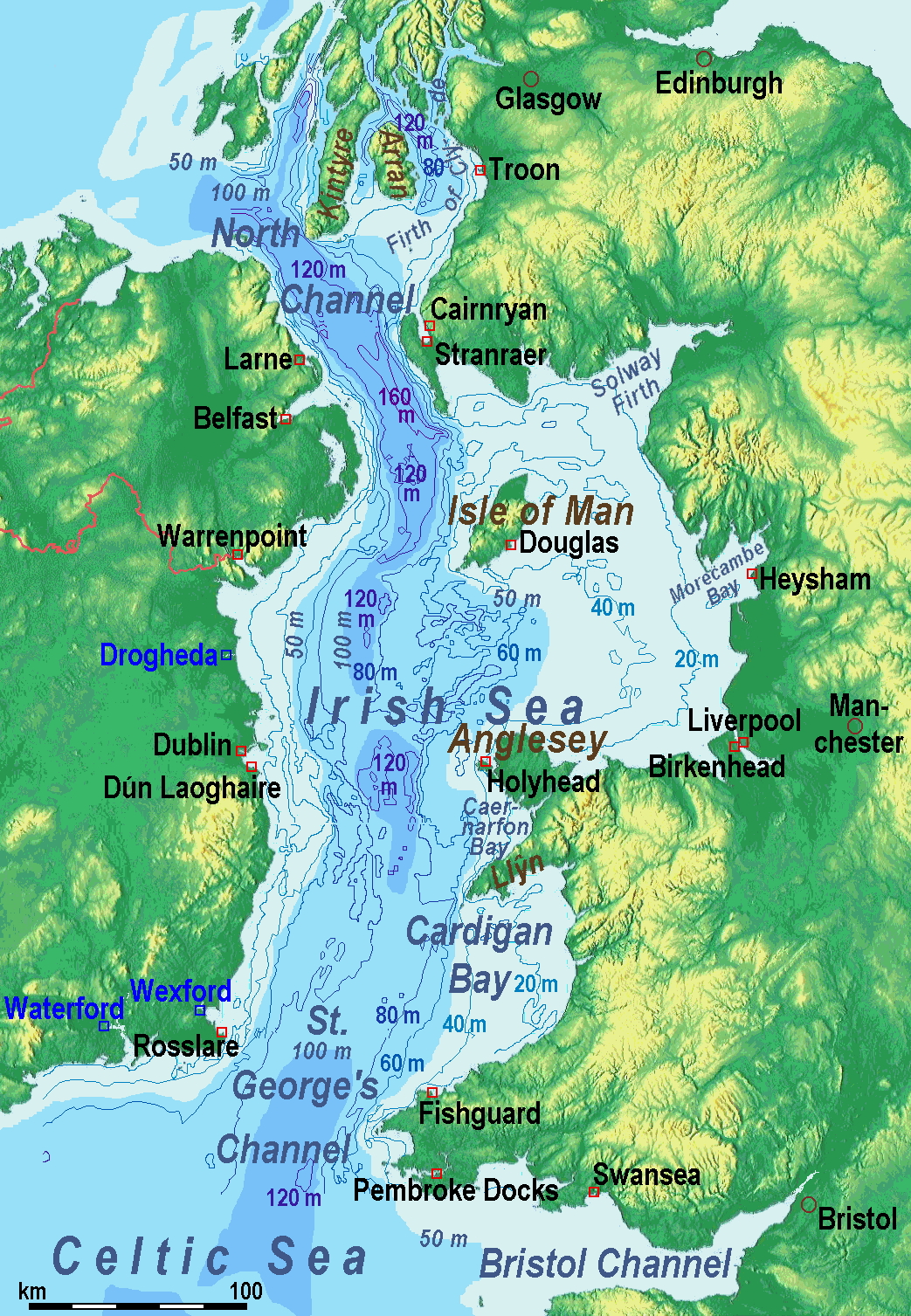
A map of the en:Irish Sea. Major ports shown with red marks. freight-only ports in blue. The old map with this lemma had significant mistakes of the bathymetry.
Therefore on 2014-05-11, it was exchanged for a completely new map. Now the bathymetric content is an own work based on various informations. The countures of depth are drawn according to the UK source, the areal colours are derived from the Irish one. The land is from Maps for Free.
15:50, 3 August 2005 Seabhcan 461×561 (93,219 bytes) (A map of the en:Irish Sea Major ports shown in red. freight only ports in blue. from [1]. Released to public domain by creator.)
Sources of information for the new map
internal report Nr. 174 of the National Oceanography Centre (Liverpool)
http://www.dcenr.gov.ie (Department of Communications, Energy and Natural Resources) -> IOSEA4Annex–Master–r02–Fiinal.pdf (Fourth Strategic Environmental Assessment for Oil and Gas ACtivity in Irelands Offshore Waters) -> figures 2.1 & 2.2a
{{Information| |Description= A map of the en:Irish Sea Major ports shown in red. freight only ports in blue. |Source= |Date= |Author=Users SFC9394, Seabhcan on [http://en.wikipedia.org en.wikipedia] |Permiss
ไฟล, irishseareliefmap, ไฟล, ประว, ไฟล, หน, าท, ภาพน, การใช, ไฟล, วนกลางขนาดของต, วอย, างน, กเซล, ความละเอ, ยดอ, กเซล, กเซล, กเซล, กเซล, ภาพท, ความละเอ, ยดส, งกว, 8206, กเซล, ขนาดไฟล, เมกะไบต, ชน, ดไมม, image, jpeg, ปภาพหร, อไฟล, เส, ยงน, นฉบ, บอย, คอมมอนส, รา. ifl prawtiifl hnathimiphaphni karichiflswnklangkhnadkhxngtwxyangni 415 600 phikesl khwamlaexiydxun 166 240 phikesl 332 480 phikesl 531 768 phikesl 1 043 1 507 phikesl duphaphthimikhwamlaexiydsungkwa 8206 1 043 1 507 phikesl khnadifl 2 15 emkaibt chnidimm image jpeg rupphaphhruxiflesiyngni tnchbbxyuthi khxmmxns raylaexiyddanlang epnkhxkhwamthiaesdngphlcak ifltnchbbinkhxmmxns khxmmxnsepnewbistinokhrngkarsahrbekbrwbrwmsuxesri thi khunsamarthchwyid enuxha 1 khwamyx 2 History of the od map 3 Sources of information for the new map 4 karxnuyatichsiththi khwamyx khaxthibayIrishSeaReliefMap jpg A map of the en Irish Sea Major ports shown with red marks freight only ports in blue The old map with this lemma had significant mistakes of the bathymetry Therefore on 2014 05 11 it was exchanged for a completely new map Now the bathymetric content is an own work based on various informations The countures of depth are drawn according to the UK source the areal colours are derived from the Irish one The land is from Maps for Free wnthi old map 2005 08 03 new map 2014 05 11 aehlngthima old map http www vindaloo uklinux net jjg code tmutils html gt new map Maps for Free and ngankhxngtw phusrangsrrkh old one Users SFC9394 Seabhcan on en wikipedia new one Ulamm talk 01 37 11 May 2014 UTC karxnuyat karichiflniihm old map from http www vindaloo uklinux net jjg code tmutils html Released to public domain by creator ewxrchnxun File Irish Sea relief ports limits tif File IrishSeaReliefmap png History of the od map Old map riginally from en wikipedia description page is was here 14 22 20 March 2006 SFC9394 461 561 85 860 bytes Corrected locations for Cairnryan amp Stranraer 10 56 25 November 2005 Seabhcan 461 561 73 292 bytes Removed the ports of Heysham and Fleetwood to which en User Robdurbar took offence 16 23 3 August 2005 Seabhcan 461 561 95 162 bytes Added channel names 15 50 3 August 2005 Seabhcan 461 561 93 219 bytes A map of the en Irish Sea Major ports shown in red freight only ports in blue from 1 Released to public domain by creator Sources of information for the new map internal report Nr 174 of the National Oceanography Centre Liverpool http www dcenr gov ie Department of Communications Energy and Natural Resources gt IOSEA4Annex Master r02 Fiinal pdf Fourth Strategic Environmental Assessment for Oil and Gas ACtivity in Irelands Offshore Waters gt figures 2 1 amp 2 2a karxnuyatichsiththi khapheca inthanaphuthuxlikhsiththikhxngphaphhruxsuxni xnuyatihichphaphhruxsuxniphayitenguxnikhtxipniiflnixyuphayitsyyaxnuyat khriexthifkhxmmxns aebbaesdngthima xnuyataebbediywkn 3 0 tnchbbkhunsamarth thicaaebngpn thicathasaena aeckcay aelasngngandngklawtxip thicaeriyberiyngihm thicaddaeplngngandngklaw phayitenguxnikhtxipni aesdngthima khuntxngihekiyrtiecakhxngnganxyangehmaasm odyephimlingkipyngsyyaxnuyat aelarabuhakmikarepliynaeplng khunxacthaechnniidinrupaebbidkidtamkhwr aettxngimichinlksnathiaenawaphuihxnuyatsnbsnunkhunhruxkarichngankhxngkhun xnuyataebbediywkn hakkhunddaeplng epliynrup hruxtxetimnganni khuntxngichsyyaxnuyataebbediywknhruxaebbthiehmuxnkbsyyaxnuyatthiichkbnganniethannhttps creativecommons org licenses by sa 3 0 CC BY SA 3 0 Creative Commons Attribution Share Alike 3 0 true true Uploaded using CommonsHelper or PushForCommons khabrryayodyyxithyephimkhabrryaythrrthdediywephuxkhyaykhwamwaiflnimixairxahrbالبحر الأيرلنديixethmthiaesdngxyuiniflniprakxbdwyphusrangbangkhathiimmiixethmwikisnethshnathikhxngwtthuphayitpraphcnni changphaphchuxphusrangsrrkh Ulammchuxphuichwikimiediy Ulammyuxaraexl http commons wikimedia org wiki User UlammsthanalikhsiththimilikhsiththisyyaxnuyatCreative Commons Attribution ShareAlike 3 0 Unported nbsp xngkvsthimakhxngiflkarsrangdngedimodyphuxpohld prawtiifl khlikwnthi ewlaephuxduiflthipraktinkhnann wnthi ewlarupyxkhnadphuichkhwamehn pccubn18 42 13 phvsphakhm 25571 043 1 507 2 15 emkaibt Ulammoptimized colour scale 21 17 12 phvsphakhm 25571 043 1 507 1 87 emkaibt Ulammmore names smaller letters 19 25 11 phvsphakhm 25571 043 1 449 1 73 emkaibt Ulammdepths and names of bays and inlets 17 56 11 phvsphakhm 25571 043 1 449 1 71 emkaibt Ulammland colours lightened 09 22 11 phvsphakhm 25571 043 1 449 1 7 emkaibt Ulammmore ports 08 50 11 phvsphakhm 25571 043 1 449 1 69 emkaibt Ulammcompletion outside the Irish Sea 08 39 11 phvsphakhm 25571 043 1 449 1 68 emkaibt Ulammcompletely new map 16 01 1 phvscikayn 2549461 561 84 kiolibt Korrigan Information Description A map of the en Irish Sea Major ports shown in red freight only ports in blue Source Date Author Users SFC9394 Seabhcan on http en wikipedia org en wikipedia Permiss hnathimiphaphni hnatxipni oyngmathiphaphni thaelixrich karichiflswnklang wikixuntxipniichiflni karichbn af wikipedia org Ierse See karichbn an wikipedia org Mar d Irlanda karichbn ast wikipedia org Mar marxinal karichbn ba wikipedia org Irlandiya dingeҙe karichbn be wikipedia org Irlandskae mora Paynochny praliy Praliy Svyatoga Georga karichbn bg wikipedia org Irlandsko more karichbn bn wikipedia org আইর শ স গর প রব শদ ব র ভ গ ল ন র ব চ ত ন বন ধ ফ ব র য র karichbn br wikipedia org Kanol Sant Jord karichbn ca wikipedia org Canal de Sant Jordi karichbn cs wikipedia org Irske more Severni pruliv Svatojirsky pruliv karichbn cv wikipedia org Irland tinĕsĕ karichbn cy wikipedia org Sianel San Sior karichbn da wikipedia org Irske Hav Randhav karichbn el wikipedia org Por8mos toy Agioy Gewrgioy Irlandikh 8alassa karichbn eo wikipedia org Irlanda Maro Kanalo de Sankta Georgo Bordomaro karichbn es wikipedia org Canal de San Jorge Mar marginal Canal del Norte islas britanicas Estrechos de Moyle karichbn eu wikipedia org San Jurgi kanala karichbn fa wikipedia org دریای ایرلند karichbn fy wikipedia org Sint Georgekanaal karichbn gl wikipedia org Canle do Norte Canal de San Xurxo karichbn gv wikipedia org Mooir Vannin Ammyr ny h Albey karichbn he wikipedia org הים האירי karichbn hu wikipedia org Ir tenger Eszaki csatorna Brit szigetek karichbn hu wiktionary org Ir tenger karichbn id wikipedia org Laut Irlandia karichbn is wikipedia org North Channel Irlandshaf karichbn ka wikipedia org ირლანდიის ზღვა ჩრდილოეთის სრუტე karichbn kk wikipedia org Soltүstik bugazy Әulie Georg bugazy karichbn ko wikipedia org 노스 해협 세인트조지 해협 karichbn ku wikipedia org Deryaya Irlendi karichbn lmo wikipedia org Canal de San Giorgg dukarichthwolkephimetimkhxngiflni ekhathungcak https th wikipedia org wiki ifl IrishSeaReliefMap jpg, wikipedia, วิกิ หนังสือ, หนังสือ, ห้องสมุด,