Reverted to version as of 19:23, 14 May 2018 (UTC) The current map is simply incorrect. And I don't want to upload a new one, I'll have to edit more than a hundred wiki-articles.
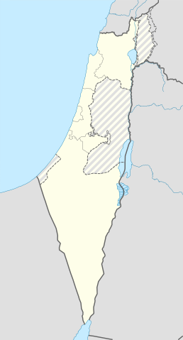
ไฟล, israel, location, with, stripes, ไฟล, ประว, ไฟล, หน, าท, ภาพน, การใช, ไฟล, วนกลาง, อม, ลเก, ยวก, บภาพขนาดของต, วอย, าง, ของไฟล, กเซล, ความละเอ, ยดอ, กเซล, กเซล, กเซล, กเซล, กเซล, กเซล, ภาพท, ความละเอ, ยดส, งกว, 8206, ไฟล, กเซล, ขนาดไฟล, โลไบต, ปภาพหร, อไฟ. ifl prawtiifl hnathimiphaphni karichiflswnklang khxmulekiywkbphaphkhnadkhxngtwxyang PNG nikhxngifl SVG ni 322 598 phikesl khwamlaexiydxun 129 240 phikesl 258 480 phikesl 413 768 phikesl 551 1 024 phikesl 1 102 2 048 phikesl 614 1 141 phikesl duphaphthimikhwamlaexiydsungkwa 8206 ifl SVG 614 1 141 phikesl khnadifl 170 kiolibt rupphaphhruxiflesiyngni tnchbbxyuthi khxmmxns raylaexiyddanlang epnkhxkhwamthiaesdngphlcak ifltnchbbinkhxmmxns khxmmxnsepnewbistinokhrngkarsahrbekbrwbrwmsuxesri thi khunsamarthchwyid khaxthibayIsrael location map with stripes svg Location map of Israel with the Palestinian territories occupied West Bank in grey stripes and not claimed Gaza Strip in full grey English en nbsp The 1949 armistice line aka the Green Line or pre 67 borders nbsp Borders of the Israeli annexed East Jerusalem and Golan Heights nbsp Non Israeli borders wnthi 15 mithunayn ph s 2557 aehlngthima Own work based on Israel location map svg nbsp ody NordNordWest phusrangsrrkh Jackmcbarn karxnuyat karichiflniihm khapheca inthanaphuthuxlikhsiththikhxngphaphhruxsuxni xnuyatihichphaphhruxsuxniphayitenguxnikhtxipni xnuyatihkhdlxk aeckcayaela hruxddaeprexksarniphayitenguxnikhkhxngsyyaxnuyatexksaresrikhxngknu run 1 2 hruxrunid nbcaknithixxkodymulnithisxftaewresri odyimmiswnidhamaekikh immikhxkhwampkhnaaelapkhlng saenakhxngsyyaxnuyatrwmxyuinswnchux syyaxnuyatexksaresrikhxngknuhttp www gnu org copyleft fdl html GFDL GNU Free Documentation License true trueiflnixyuphayitsyyaxnuyat khriexthifkhxmmxns aebbaesdngthima xnuyataebbediywkn 3 0 tnchbbkhunsamarth thicaaebngpn thicathasaena aeckcay aelasngngandngklawtxip thicaeriyberiyngihm thicaddaeplngngandngklaw phayitenguxnikhtxipni aesdngthima khuntxngihekiyrtiecakhxngnganxyangehmaasm odyephimlingkipyngsyyaxnuyat aelarabuhakmikarepliynaeplng khunxacthaechnniidinrupaebbidkidtamkhwr aettxngimichinlksnathiaenawaphuihxnuyatsnbsnunkhunhruxkarichngankhxngkhun xnuyataebbediywkn hakkhunddaeplng epliynrup hruxtxetimnganni khuntxngichsyyaxnuyataebbediywknhruxaebbthiehmuxnkbsyyaxnuyatthiichkbnganniethannhttps creativecommons org licenses by sa 3 0 CC BY SA 3 0 Creative Commons Attribution Share Alike 3 0 true truekhunsamartheluxksyyaxnuyatdngklawtamtxngkar SVG nbsp genesisInfoField nbsp sxrsokhdkhxng SVG nitrwcsxbthuktxngaelw nbsp iflphaphkrafiksewketxrni srangkhunodyich nbsp Other toolskhabrryayodyyxithyephimkhabrryaythrrthdediywephuxkhyaykhwamwaiflnimixairixethmthiaesdngxyuiniflniprakxbdwysthanalikhsiththimilikhsiththisyyaxnuyatCreative Commons Attribution ShareAlike 3 0 Unported nbsp xngkvsGNU Free Documentation License version 1 2 or lateral nbsp xngkvswnthisrang wnkxtng15 mithunayn 2014 prawtiifl khlikwnthi ewlaephuxduiflthipraktinkhnann lasud ekasud du ihmkwa 10 ekakwa 10 10 20 50 100 250 500 wnthi ewlarupyxkhnadphuichkhwamehn pccubn21 43 16 mithunayn 2561614 1 141 170 kiolibt JdxReverted to version as of 10 35 16 June 2018 UTC 21 04 16 mithunayn 2561504 936 170 kiolibt BeebbeebeReverted to version as of 00 40 16 June 2018 UTC don 039 t revert without stating a reason 17 35 16 mithunayn 2561614 1 141 170 kiolibt DennissReverted to version as of 04 28 21 May 2018 UTC 07 40 16 mithunayn 2561504 936 170 kiolibt BeebbeebeReverted to version as of 19 23 14 May 2018 UTC The current map is simply incorrect And I don 039 t want to upload a new one I 039 ll have to edit more than a hundred wiki articles 11 28 21 phvsphakhm 2561614 1 141 170 kiolibt NableezyReverted to version as of 19 08 18 September 2016 UTC actually go back to standard no green or blue lines 01 23 16 phvsphakhm 2561614 1 141 174 kiolibt NableezyReverted to version as of 03 49 14 May 2018 UTC 02 23 15 phvsphakhm 2561504 936 170 kiolibt Eric s sonReverted to version as of 13 42 24 March 2018 UTC 10 49 14 phvsphakhm 2561614 1 141 174 kiolibt NableezyReverted to version as of 06 09 11 March 2018 UTC restore golan as occupied territory 20 42 24 minakhm 2561504 936 170 kiolibt Eric s sonCorrecting color for border with Jordan 20 26 24 minakhm 2561504 936 170 kiolibt Eric s sonFixed correct colors with vector lasud ekasud du ihmkwa 10 ekakwa 10 10 20 50 100 250 500 hnathimiphaphni hnatxipni oyngmathiphaphni thaxakasyannanachatiebnkueriyn futbxlchingaechmpaehngchatiyuorp runxayuimekin 21 pi 2013 msyidkhaw nasaerth msyidkhaw xrrxmlah raychuxaehlngmrdkolkinpraethsxisraexl xisraexlphriemiyrlik ebiyrchiba eyrusaelm ihfa mxdul Location map data Israel mxdul Location map data Israel doc karichiflswnklang wikixuntxipniichiflni karichbn af wikipedia org Rehovot Nasaret Eilat Dimona Ramla Safed Tiberias Lod Ben Gurion Internasionale Lughawe Hadera Gedera Givatayim Be er Sheva Rishon LeZion Petah Tikva Ashdod Netanya Binyamina Giv at Ada Bnei Brak Holon Ramat Gan Ashkelon Bat Yam Beit Shemesh Kfar Saba Herzliya Modi in Maccabim Re ut Ra anana Ramon lughawe karichbn an wikipedia org Cherusalem Nazaret Plantilla Mapa de localizacion Israel karichbn ar wikipedia org القوات الجوية الإسرائيلية قلعة كوكب الهوا إبطن جفعاتايم قالب Location map Israel Golan قالب Location map Israel ashkelon قالب Location map Israel binyamin قالب Location map Israel center ta قالب Location map Israel haifa قالب Location map Israel jezreel قالب Location map Israel negev mt قالب Location map Israel north haifa قالب Location map Israel north negev قالب Location map Israel northeast قالب Location map Israel northwest قالب Location map Israel northwest negev قالب Location map Israel shomron قالب Location map Israel south wb dukarichthwolkephimetimkhxngiflnikhxmulekiywkbphaph phaphnimikhxmulephimetim sungswnihymacakklxngdicitxlhruxsaeknenxrthisamarthekbkhxmuldngklawiwrwmkbphaphid thaphaphnithukprbprungaekikhhruxepliynaeplngcakedim khxmulbangxyangcayngkhngimepliynaeplngehmuxnphaphthithukprbprungaekikhnnkhwamkwang614 48682khwamsung1141 491 ekhathungcak https th wikipedia org wiki ifl Israel location map with stripes svg, wikipedia, วิกิ หนังสือ, หนังสือ, ห้องสมุด,