ภาพแผนที่ระบุตำแหน่งนี้ ควรจะถูกสร้างใหม่เป็นกราฟิกส์เวกเตอร์ ซึ่งมีข้อดีอีกหลายประการ ดูเพิ่มเติมที่คอมมอนส์:สื่อต้องการเก็บกวาดสำหรับสารสนเทศเพิ่มเติม หากภาพนี้มีในรูปแบบกราฟิกส์เวกเตอร์อยู่แล้ว กรุณาอัปโหลดและแทนที่แม่แบบนี้ด้วย {{vector version available|ชื่อภาพใหม่}} แนะนำเป็นอย่างยิ่งให้ตั้งชื่อไฟล์เวกเตอร์ใหม่นั้นในรูปแบบ "Kara Sea map.svg" แล้วใส่แม่แบบ Vector version available (หรือ Vva) ซึ่งไม่ต้องใช้พารามิเตอร์ ชื่อภาพใหม่
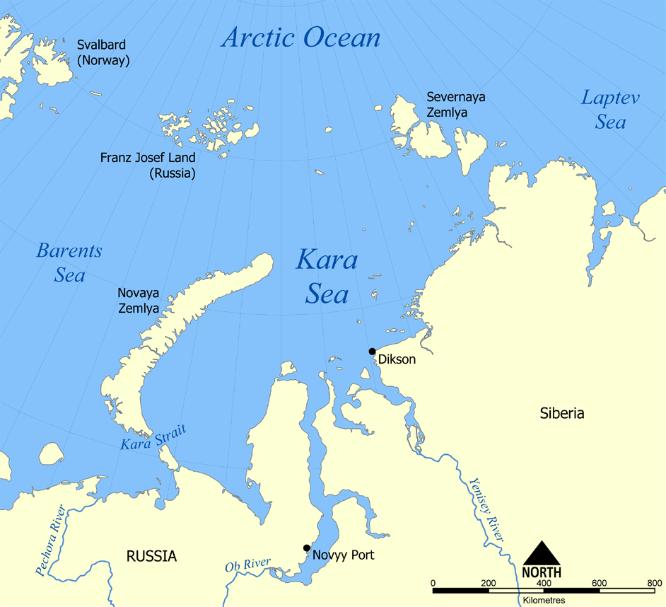
This map shows the location of the Kara Sea north of Russia. The sea is located south of the Arctic Ocean, east of the Barents Sea, west of the Laptev Sea, and is bounded by the Severnaya Zemlya and Novaya Zemlya.
This map shows the location of the Kara Sea north of Russia. The sea is located south of the Arctic Ocean, east of the Barents Sea, west of the Laptev Sea, and is bounded by the Severnaya Zemlya and Novaya Zemlya. Created by NormanEinstein, November 29,
ไฟล, kara, ไฟล, ประว, ไฟล, หน, าท, ภาพน, การใช, ไฟล, วนกลางขนาดของต, วอย, างน, กเซล, ความละเอ, ยดอ, กเซล, กเซล, กเซล, ภาพท, ความละเอ, ยดส, งกว, 8206, กเซล, ขนาดไฟล, โลไบต, ชน, ดไมม, image, ปภาพหร, อไฟล, เส, ยงน, นฉบ, บอย, คอมมอนส, รายละเอ, ยดด, านล, าง, เป, นข. ifl prawtiifl hnathimiphaphni karichiflswnklangkhnadkhxngtwxyangni 658 599 phikesl khwamlaexiydxun 264 240 phikesl 527 480 phikesl 942 858 phikesl duphaphthimikhwamlaexiydsungkwa 8206 942 858 phikesl khnadifl 258 kiolibt chnidimm image png rupphaphhruxiflesiyngni tnchbbxyuthi khxmmxns raylaexiyddanlang epnkhxkhwamthiaesdngphlcak ifltnchbbinkhxmmxns khxmmxnsepnewbistinokhrngkarsahrbekbrwbrwmsuxesri thi khunsamarthchwyid phaphaephnthirabutaaehnngni khwrcathuksrangihmepnkrafiksewketxr sungmikhxdixikhlayprakar duephimetimthikhxmmxns suxtxngkarekbkwadsahrbsarsnethsephimetim hakphaphnimiinrupaebbkrafiksewketxrxyuaelw krunaxpohldaelaaethnthiaemaebbnidwy vector version available i chuxphaphihm i aenanaepnxyangyingihtngchuxiflewketxrihmnninrupaebb Kara Sea map svg aelwisaemaebb Vector version available hrux Vva sungimtxngichpharamietxr chuxphaphihm This map shows the location of the Kara Sea north of Russia The sea is located south of the Arctic Ocean east of the Barents Sea west of the Laptev Sea and is bounded by the Severnaya Zemlya and Novaya Zemlya Created by NormanEinstein November 29 2005 khapheca inthanaphuthuxlikhsiththikhxngphaphhruxsuxni xnuyatihichphaphhruxsuxniphayitenguxnikhtxipni xnuyatihkhdlxk aeckcayaela hruxddaeprexksarniphayitenguxnikhkhxngsyyaxnuyatexksaresrikhxngknu run 1 2 hruxrunid nbcaknithixxkodymulnithisxftaewresri odyimmiswnidhamaekikh immikhxkhwampkhnaaelapkhlng saenakhxngsyyaxnuyatrwmxyuinswnchux syyaxnuyatexksaresrikhxngknuhttp www gnu org copyleft fdl html GFDL GNU Free Documentation License true true iflnixyuphayitsyyaxnuyat khriexthifkhxmmxns aebbaesdngthima xnuyataebbediywkn 3 0 tnchbb khunsamarth thicaaebngpn thicathasaena aeckcay aelasngngandngklawtxip thicaeriyberiyngihm thicaddaeplngngandngklaw phayitenguxnikhtxipni aesdngthima khuntxngihekiyrtiecakhxngnganxyangehmaasm odyephimlingkipyngsyyaxnuyat aelarabuhakmikarepliynaeplng khunxacthaechnniidinrupaebbidkidtamkhwr aettxngimichinlksnathiaenawaphuihxnuyatsnbsnunkhunhruxkarichngankhxngkhun xnuyataebbediywkn hakkhunddaeplng epliynrup hruxtxetimnganni khuntxngichsyyaxnuyataebbediywknhruxaebbthiehmuxnkbsyyaxnuyatthiichkbnganniethann payaesdngsthanalikhsiththinithukephimephuxihepniptamkarepliynaeplngsyyaxnuyatkhxngmulnithiwikimiediy cak GFDL ipyng GFDL khwbkhukb CC BY SA 3 0 http creativecommons org licenses by sa 3 0 CC BY SA 3 0 Creative Commons Attribution Share Alike 3 0 true truekhunsamartheluxksyyaxnuyatdngklawtamtxngkar derivative works iflxunthiichiflni EPNZ 1 3 oil and gas areas png Kara Sea map hr svg Kara Sea map hu svgkhabrryayodyyxithyephimkhabrryaythrrthdediywephuxkhyaykhwamwaiflnimixairsepnMap of Kara SeaixethmthiaesdngxyuiniflniprakxbdwythaelkharasthanalikhsiththimilikhsiththisyyaxnuyatCreative Commons Attribution ShareAlike 3 0 Unported nbsp xngkvsGNU Free Documentation License version 1 2 or lateral nbsp xngkvs prawtiifl khlikwnthi ewlaephuxduiflthipraktinkhnann wnthi ewlarupyxkhnadphuichkhwamehn pccubn03 26 15 krkdakhm 2555942 858 258 kiolibt Ras67cropped opt 05 12 30 phvscikayn 2548952 868 382 kiolibt NormanEinsteinThis map shows the location of the Kara Sea north of Russia The sea is located south of the Arctic Ocean east of the Barents Sea west of the Laptev Sea and is bounded by the Severnaya Zemlya and Novaya Zemlya Created by NormanEinstein November 29 hnathimiphaphni hnatxipni oyngmathiphaphni thaelkhara karichiflswnklang wikixuntxipniichiflni karichbn af wikipedia org Karasee karichbn an wikipedia org Lista d oceanos y mars d o mundo seguntes a IHO karichbn ar wikipedia org بحر كارا السياسة القطبية الشمالية لروسيا karichbn avk wikipedia org Vexala dem bireem karichbn azb wikipedia org کارا دنیزی karichbn az wikipedia org Kara denizi karichbn be wikipedia org Karskiya Varoty karichbn bg wikipedia org Karsko more karichbn bn wikipedia org ক র স গর karichbn br wikipedia org Mor Kara karichbn bs wikipedia org Karsko more karichbn ca wikipedia org Mar Cornelis Nay karichbn cs wikipedia org Karske more karichbn cy wikipedia org Mor Kara karichbn da wikipedia org Karahavet Cornelis Corneliszoon Nay karichbn de wikipedia org Karasee Jenissei Dikson Karastrasse karichbn en wikipedia org Kara Sea User NormanEinstein gallery Cornelis Nay Operation Wunderland List of Russian explorers Arctic policy of Russia Wikipedia Featured list candidates List of Russian explorers archive1 Wikipedia Featured list candidates Failed log January 2012 North Kara basin Rusanov expedition karichbn en wiktionary org Severnaya Zemlya karichbn eo wikipedia org Kara markolo Karaa maro karichbn es wikipedia org Mar de Kara Anexo Oceanos y mares del mundo Dikson Novy Port Plataforma continental siberiana Politica artica de Rusia karichbn eu wikipedia org Kara Karako itsasartea karichbn fa wikipedia org دریای کارا karichbn fi wikipedia org Karanmeri Karansalmi karichbn frr wikipedia org Kara Sia karichbn fr wikipedia org Liste des oceans et mers du monde selon l Organisation hydrographique internationale Cornelis Nay karichbn fy wikipedia org Karasee dukarichthwolkephimetimkhxngiflni ekhathungcak https th wikipedia org wiki ifl Kara Sea map png, wikipedia, วิกิ หนังสือ, หนังสือ, ห้องสมุด,