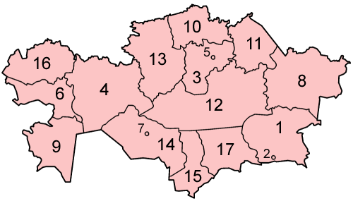
Map of the provinces of Kazakhstan in alphabetical order in English. Made by User:Golbez based on a PD United Nations map; its borders are different from the available CIA maps, but the UN map is several years newer. Category:Maps of Kazakhstan
หน้าที่มีภาพนี้
ไม่มีหน้าใดโยงมาที่ภาพนี้
การใช้ไฟล์ส่วนกลาง
วิกิอื่นต่อไปนี้ใช้ไฟล์นี้:
Kazakhstanen banaketa administratiboa
Вилоятҳои Қазоқистон
มกราคม 23, 2023
ไฟล, kazakhstan, provinces, numbered, english, ไฟล, ประว, ไฟล, หน, าท, ภาพน, การใช, ไฟล, วนกลางไม, ภาพท, รายละเอ, ยดส, งกว, าน, kazakhstan, provinces, numbered, english, 8206, กเซล, ขนาดไฟล, โลไบต, ชน, ดไมม, image, ปภาพหร, อไฟล, เส, ยงน, นฉบ, บอย, คอมมอนส, ราย. ifl prawtiifl hnathimiphaphni karichiflswnklangimmiphaphthimiraylaexiydsungkwani Kazakhstan provinces numbered english png 8206 500 285 phikesl khnadifl 14 kiolibt chnidimm image png rupphaphhruxiflesiyngni tnchbbxyuthi khxmmxns raylaexiyddanlang epnkhxkhwamthiaesdngphlcak ifltnchbbinkhxmmxns khxmmxnsepnewbistinokhrngkarsahrbekbrwbrwmsuxesri thi khunsamarthchwyid khwamyx khaxthibayKazakhstan provinces numbered english png Map of the provinces of Kazakhstan in alphabetical order in English Made by User Golbez based on a PD United Nations map its borders are different from the available CIA maps but the UN map is several years newer wnthi 6 mkrakhm ph s 2549 original upload date aehlngthima No machine readable source provided Own work assumed based on copyright claims phusrangsrrkh No machine readable author provided Golbez assumed based on copyright claims karxnuyatichsiththi khapheca inthanaphuthuxlikhsiththikhxngphaphhruxsuxni xnuyatihichphaphhruxsuxniphayitenguxnikhtxipni xnuyatihkhdlxk aeckcayaela hruxddaeprexksarniphayitenguxnikhkhxngsyyaxnuyatexksaresrikhxngknu run 1 2 hruxrunid nbcaknithixxkodymulnithisxftaewresri odyimmiswnidhamaekikh immikhxkhwampkhnaaelapkhlng saenakhxngsyyaxnuyatrwmxyuinswnchux syyaxnuyatexksaresrikhxngknuhttp www gnu org copyleft fdl html GFDL GNU Free Documentation License true trueiflnixyuphayitsyyaxnuyat khriexthifkhxmmxns aebbaesdngthima xnuyataebbediywkn 3 0 tnchbbkhunsamarth thicaaebngpn thicathasaena aeckcay aelasngngandngklawtxip thicaeriyberiyngihm thicaddaeplngngandngklaw phayitenguxnikhtxipni aesdngthima khuntxngihekiyrtiecakhxngnganxyangehmaasm odyephimlingkipyngsyyaxnuyat aelarabuhakmikarepliynaeplng khunxacthaechnniidinrupaebbidkidtamkhwr aettxngimichinlksnathiaenawaphuihxnuyatsnbsnunkhunhruxkarichngankhxngkhun xnuyataebbediywkn hakkhunddaeplng epliynrup hruxtxetimnganni khuntxngichsyyaxnuyataebbediywknhruxaebbthiehmuxnkbsyyaxnuyatthiichkbnganniethannpayaesdngsthanalikhsiththinithukephimephuxihepniptamkarepliynaeplngsyyaxnuyatkhxngmulnithiwikimiediy cak GFDL ipyng GFDL khwbkhukb CC BY SA 3 0 http creativecommons org licenses by sa 3 0 CC BY SA 3 0 Creative Commons Attribution Share Alike 3 0 true trueiflnixyuphayitsyyaxnuyatkhriexthifkhxmmxns runaesdngthima 2 5 thwipkhunsamarth thicaaebngpn thicathasaena aeckcay aelasngngandngklawtxip thicaeriyberiyngihm thicaddaeplngngandngklaw phayitenguxnikhtxipni aesdngthima khuntxngihekiyrtiecakhxngnganxyangehmaasm odyephimlingkipyngsyyaxnuyat aelarabuhakmikarepliynaeplng khunxacthaechnniidinrupaebbidkidtamkhwr aettxngimichinlksnathiaenawaphuihxnuyatsnbsnunkhunhruxkarichngankhxngkhunhttps creativecommons org licenses by 2 5 CC BY 2 5 Creative Commons Attribution 2 5 true truekhunsamartheluxksyyaxnuyatdngklawtamtxngkarkhabrryayodyyxithyephimkhabrryaythrrthdediywephuxkhyaykhwamwaiflnimixairixethmthiaesdngxyuiniflniprakxbdwysthanalikhsiththimilikhsiththisyyaxnuyatCreative Commons Attribution 2 5 Generic xngkvsGNU Free Documentation License version 1 2 or later xngkvsCreative Commons Attribution ShareAlike 3 0 Unported xngkvswnthisrang wnkxtng6 mkrakhm 2006 prawtiifl khlikwnthi ewlaephuxduiflthipraktinkhnann wnthi ewlarupyxkhnadphuichkhwamehn pccubn12 32 6 mkrakhm 2549500 285 14 kiolibt GolbezMap of the provinces of Kazakhstan in alphabetical order in English Made by User Golbez based on a PD United Nations map its borders are different from the available CIA maps but the UN map is several years newer Category Maps of Kazakhstan hnathimiphaphni immihnaidoyngmathiphaphnikarichiflswnklang wikixuntxipniichiflni karichbn ca wikipedia org Kazakhstan karichbn en wikipedia org User Jonny mt Gallery of current first level administrative country subdivisions maps karichbn eu wikipedia org Kazakhstan Kazakhstanen banaketa administratiboa karichbn fi wikipedia org Kazakstan karichbn gl wikipedia org Subdivisions de Casaquistan karichbn nl wikipedia org Deelgebieden van Kazachstan karichbn nn wikipedia org Oblast i Kasakhstan karichbn pt wikipedia org Subdivisoes do Cazaquistao karichbn sv wikipedia org Kazakstan karichbn tg wikipedia org Қazokiston Viloyatҳoi Қazokiston karichbn wuu wikipedia org 直轄市 ekhathungcak https th wikipedia org wiki ifl Kazakhstan provinces numbered english png, wikipedia, วิกิ หนังสือ, หนังสือ, ห้องสมุด,