The geographical information in this file was retrospectively estimated. The location may therefore be somewhat imprecise. Verifying and refining these coordinates is strongly encouraged.
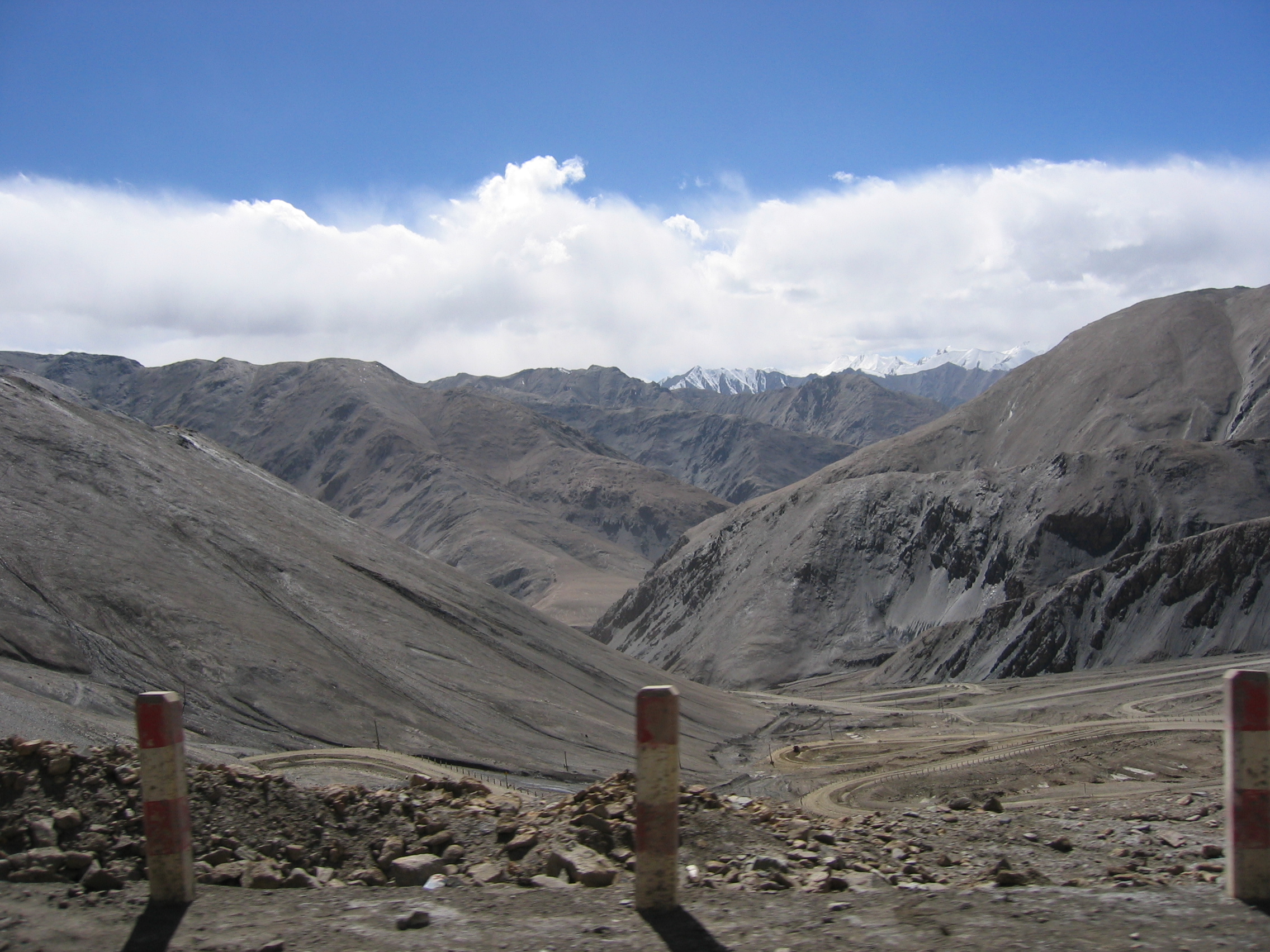
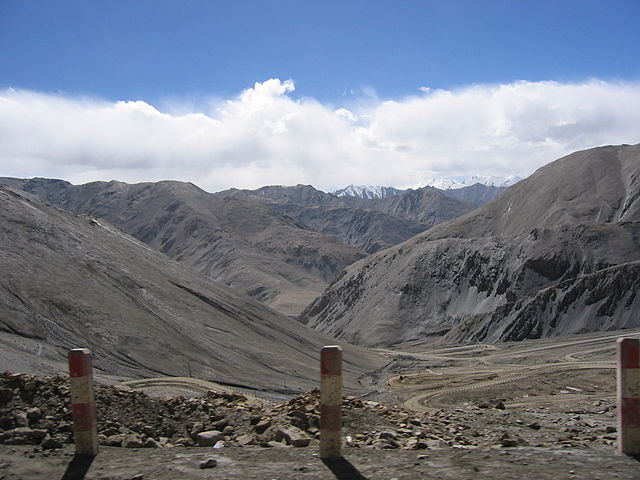
{{Information |Description=View of Western Kunlun Shan from the Tibet-Xinjiang highway |Source=[http://en.wikipedia.org/wiki/Image:IMG_0541.jpg en] |Date= July of 2004 while on a geological expedition from UC Davis |Author=Photo taken by Nick Kent-Basham
ไฟล, kunlun, 0541, ไฟล, ประว, ไฟล, หน, าท, ภาพน, การใช, ไฟล, ามโครงการ, อม, ลเก, ยวก, บภาพขนาดของต, วอย, างน, กเซล, ความละเอ, ยดอ, กเซล, กเซล, กเซล, กเซล, กเซล, ภาพท, ความละเอ, ยดส, งกว, 8206, กเซล, ขนาดไฟล, เมกะไบต, ชน, ดไมม, image, jpeg, ปภาพหร, อไฟล, เส, ยง. ifl prawtiifl hnathimiphaphni karichiflkhamokhrngkar khxmulekiywkbphaphkhnadkhxngtwxyangni 800 600 phikesl khwamlaexiydxun 320 240 phikesl 640 480 phikesl 1 024 768 phikesl 1 280 960 phikesl 2 272 1 704 phikesl duphaphthimikhwamlaexiydsungkwa 8206 2 272 1 704 phikesl khnadifl 1 56 emkaibt chnidimm image jpeg rupphaphhruxiflesiyngni tnchbbxyuthi khxmmxns raylaexiyddanlang epnkhxkhwamthiaesdngphlcak ifltnchbbinkhxmmxns khxmmxnsepnewbistinokhrngkarsahrbekbrwbrwmsuxesri thi khunsamarthchwyid khaxthibayKunlun IMG 0541 jpg English View of Western Kunlun Shan from the Tibet Xinjiang highway wnthi July of 2004 while on a geological expedition from UC Davis aehlngthima en phusrangsrrkh Photo taken by Nick Kent Basham karxnuyat karichiflniihm Public domain Public domain false false nganniidthukephyaephrsusatharnsmbtiodyecakhxng Nick Kent Basham sungmiphlthwolkinbangpraeths karkrathadngklawxacimsamarththaidtamkdhmayNick Kent Basham xnuyatihthukkhnmisiththiinkarichiflniinthukehtuphlkarich odyimmimienguxnikh ewnaetkdhmayimxnuyatihthaechnnn Public domain Public domain false false taaehnngthitngklxng36 nbsp 26 nbsp 06 36 nbsp ehnux 77 nbsp 34 nbsp 38 82 nbsp tawnxxk nbsp phaphniaelaphaphxun n sthanthiediywknthi OpenStreetMap36 435100 77 577450 The geographical information in this file was retrospectively estimated The location may therefore be somewhat imprecise Verifying and refining these coordinates is strongly encouraged khabrryayodyyxithyephimkhabrryaythrrthdediywephuxkhyaykhwamwaiflnimixairxngkvsLooking at the West Kunlun Mountains from the Xinjiang Tibet Highway at the Heiqiazi Daban Heiqia Daban Heika Daban Black Clip Daban cin由新藏公路的科克阿尔特达坂 黑卡子达坂 黑卡达坂 望向西昆仑山脉rsesiyKun Lunixethmthiaesdngxyuiniflniprakxbdwysthanalikhsiththicopyrighted dedicated to the public domain by copyright holder nbsp xngkvssyyaxnuyatreleased into the public domain by the copyright holder nbsp xngkvscoordinates of the point of view nbsp xngkvs36 26 6 36 N 77 34 38 82 EMIME type nbsp xngkvsimage jpeg prawtiifl khlikwnthi ewlaephuxduiflthipraktinkhnann wnthi ewlarupyxkhnadphuichkhwamehn pccubn02 48 12 minakhm 25502 272 1 704 1 56 emkaibt Hugo arg Information Description View of Western Kunlun Shan from the Tibet Xinjiang highway Source http en wikipedia org wiki Image IMG 0541 jpg en Date July of 2004 while on a geological expedition from UC Davis Author Photo taken by Nick Kent Basham hnathimiphaphni hnatxipni oyngmathiphaphni ethuxkekhakhunhlun karichiflkhamokhrngkar wikixuntxipniichiflni karichbn af wikipedia org Kunlun karichbn ast wikipedia org Kunlun karichbn ba wikipedia org Kunlun karichbn be wikipedia org Kunlun karichbn bg wikipedia org Kunlun karichbn bn wikipedia org ক য নল ন পর বতম ল karichbn ca wikipedia org Kunlun karichbn cs wikipedia org Kchun lun san karichbn de wikipedia org Kunlun karichbn en wikipedia org China National Highway 219 Hindutash Pass Kirgizjangal Pass North Tibetan Plateau Kunlun Mountains alpine desert karichbn es wikipedia org Anexo Cadenas montanosas mas largas de la Tierra karichbn he wikipedia org הרי קונלון karichbn hr wikipedia org Kunlun karichbn hu wikipedia org Kunlun karichbn it wikipedia org Hindutash Deserto alpino dell altopiano del Tibet settentrionale e dei monti Kunlun karichbn ka wikipedia org კუნლუნი karichbn ko wikipedia org 쿤룬산맥 karichbn lt wikipedia org Kunlunas karichbn nl wikipedia org Kunlun karichbn no wikipedia org Kunlunfjellene karichbn ro wikipedia org Munții Kunlun karichbn ru wikipedia org Kunlun karichbn sh wikipedia org Kunlun karichbn sk wikipedia org Kchun lun karichbn sr wikipedia org Kuenluen karichbn sv wikipedia org Kunlun karichbn sw wikipedia org Milima ya Kunlun karichbn tt wikipedia org Kunlun karichbn ug wikipedia org كۇئېنلۇن تاغ تىزمىسى karichbn uk wikipedia org Kunlun Alpijska pustelya Pivnichnogo Tibetu ta Kunlunyu karichbn vi wikipedia org Day nui Con Lon Địa ly Trung Quốc karichbn www wikidata org Q70156693 karichbn zh wikipedia org 昆仑山脉 柯克阿特达坂khxmulekiywkbphaph phaphnimikhxmulephimetim sungswnihymacakklxngdicitxlhruxsaeknenxrthisamarthekbkhxmuldngklawiwrwmkbphaphid thaphaphnithukprbprungaekikhhruxepliynaeplngcakedim khxmulbangxyangcayngkhngimepliynaeplngehmuxnphaphthithukprbprungaekikhnnphuphlitklxngCanonrunkhxngklxngCanon PowerShot S410ewlaepidhnaklxng1 640 winathi 0 0015625 khaexff 7 1ewlathibnthukphaph01 30 18 knyayn 2547khwamyawofkselns7 40625 mm karcdwangphaphpktikhwamlaexiydaenwnxn180 dpikhwamlaexiydaenwtng180 dpiaekikhphaphlasud01 30 18 knyayn 2547taaehnng Y aela Ckungklangrunexksif Exif 2 2ewlathiaeplngepndicithl01 30 18 knyayn 2547ohmdkarbibxdphaph5khwamerwchtetxr9 3125kharurbaesng A 5 65625karchdechyaesng0rurbaesngkwangsud2 96875 APEX f 2 8 ohmdkarwdaesngaephtethirnaeflchimichaeflch ohmdxtonmtisepssisRGBkhwamlaexiydranabofks X8 114 2857142857khwamlaexiydranabofks Y8 114 2857142857hnwykhwamlaexiydranabofksniwwithikarwdesnesxrcudediywkarpramwlphaphophlessspktiohmdexksophechxrexksophechxrxtonmtiiwtbalansiwtbalansxtonmtidicithlsum1chnidsinaekhpecxrpkti ekhathungcak https th wikipedia org wiki ifl Kunlun IMG 0541 jpg, wikipedia, วิกิ หนังสือ, หนังสือ, ห้องสมุด,