This is an image of a place or building that is listed on the National Register of Historic Places in the United States of America. Its reference number is 85001757.
คำอธิบายKwajalein-closing in.jpeg
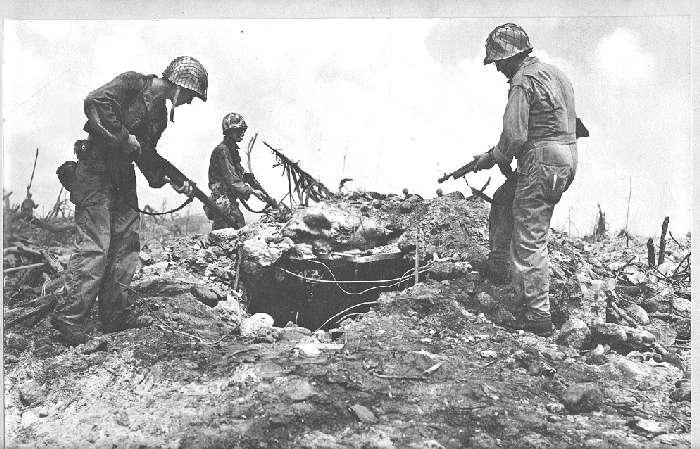
English: US troops inspecting an enemy bunker, Kwajalein Atoll.
วันที่
แหล่งที่มา
National Park Service - US Dept of the Interior.
ผู้สร้างสรรค์
Unknown. Official U.S. Army Signal Corps Photograph, Graflex-Made. Donated by Joseph Garofalo - 121st Seabees, 4th Marine Division.
ไฟล, kwajalein, closing, jpeg, ไฟล, ประว, ไฟล, หน, าท, ภาพน, การใช, ไฟล, วนกลาง, อม, ลเก, ยวก, บภาพไม, ภาพท, รายละเอ, ยดส, งกว, าน, kwajalein, closing, jpeg, 8206, กเซล, ขนาดไฟล, โลไบต, ชน, ดไมม, image, jpeg, ปภาพหร, อไฟล, เส, ยงน, นฉบ, บอย, คอมมอนส, รายละเอ, . ifl prawtiifl hnathimiphaphni karichiflswnklang khxmulekiywkbphaphimmiphaphthimiraylaexiydsungkwani Kwajalein closing in jpeg 8206 700 449 phikesl khnadifl 61 kiolibt chnidimm image jpeg rupphaphhruxiflesiyngni tnchbbxyuthi khxmmxns raylaexiyddanlang epnkhxkhwamthiaesdngphlcak ifltnchbbinkhxmmxns khxmmxnsepnewbistinokhrngkarsahrbekbrwbrwmsuxesri thi khunsamarthchwyid This is an image of a place or building that is listed on the National Register of Historic Places in the United States of America Its reference number is 85001757 khaxthibayKwajalein closing in jpeg English US troops inspecting an enemy bunker Kwajalein Atoll wnthi ph s 2487aehlngthima National Park Service US Dept of the Interior phusrangsrrkh Unknown Official U S Army Signal Corps Photograph Graflex Made Donated by Joseph Garofalo 121st Seabees 4th Marine Division taaehnngkhxngwtthuhruxsthanthi8 43 08 ehnux 167 43 55 tawnxxk phaphniaelaphaphxun n sthanthiediywknthi OpenStreetMap8 718889 167 731944karxnuyatichsiththi Public domain Public domain false falseThis file is a work of a U S Army soldier or employee taken or made as part of that person s official duties As a work of the U S federal government it is in the public domain in the United States العربية ব ল catala cestina Deutsch English espanol eesti فارسی suomi francais hrvatski magyar Bahasa Indonesia italiano 日本語 한국어 lietuviu makedonski മലയ ള မ န မ ဘ သ Nederlands polski portugues russkij sicilianu srpski srpski Turkce ukrayinska Tiếng Việt 中文 简体 中文 繁體 bnthukkarxphohldnaekhacak en wikipedia mayngkhxmmxns ody Kurpfalzbilder de odyich CommonsHelperThe original description page was here All following user names refer to en wikipedia 2004 05 10 20 59 Kevin Saff 700 449 62809 bytes Kwajalein closing inkhabrryayodyyxithyephimkhabrryaythrrthdediywephuxkhyaykhwamwaiflnimixairixethmthiaesdngxyuiniflniprakxbdwyKwajalein Island Battlefield xngkvswnthisrang wnkxtng1944coordinates of depicted place xngkvs8 43 8 000 N 167 43 54 998 Elocation of creation xngkvsKwajalein xngkvs prawtiifl khlikwnthi ewlaephuxduiflthipraktinkhnann wnthi ewlarupyxkhnadphuichkhwamehn pccubn08 41 16 minakhm 2553700 449 61 kiolibt File Upload Bot Magnus Manske BotMoveToCommons en wikipedia year subst CURRENTYEAR month subst CURRENTMONTHNAME day subst CURRENTDAY Information Description en US troops inspecting an enemy bunker en Kwajalein Atoll Source Transferred from http en w hnathimiphaphni immihnaidoyngmathiphaphnikarichiflswnklang wikixuntxipniichiflni karichbn ami wikipedia org Marshall Islands karichbn ca wikipedia org Kwajalein karichbn en wikipedia org History of the Marshall Islands Kwajalein Atoll National Register of Historic Places listings in the Marshall Islands karichbn he wikipedia org קווג לין karichbn it wikipedia org Campagna delle isole Gilbert e Marshall karichbn ml wikipedia org മ ർഷൽ ദ വ പ കൾ karichbn tr wikipedia org Kwajalein Atolu karichbn uk wikipedia org Marshallovi Ostrovi karichbn wuu wikipedia org 馬紹爾群島 karichbn zh wikipedia org 馬紹爾群島 馬紹爾人khxmulekiywkbphaph phaphnimikhxmulephimetim sungswnihymacakklxngdicitxlhruxsaeknenxrthisamarthekbkhxmuldngklawiwrwmkbphaphid thaphaphnithukprbprungaekikhhruxepliynaeplngcakedim khxmulbangxyangcayngkhngimepliynaeplngehmuxnphaphthithukprbprungaekikhnn error0 ekhathungcak https th wikipedia org wiki ifl Kwajalein closing in jpeg, wikipedia, วิกิ หนังสือ, หนังสือ, ห้องสมุด,