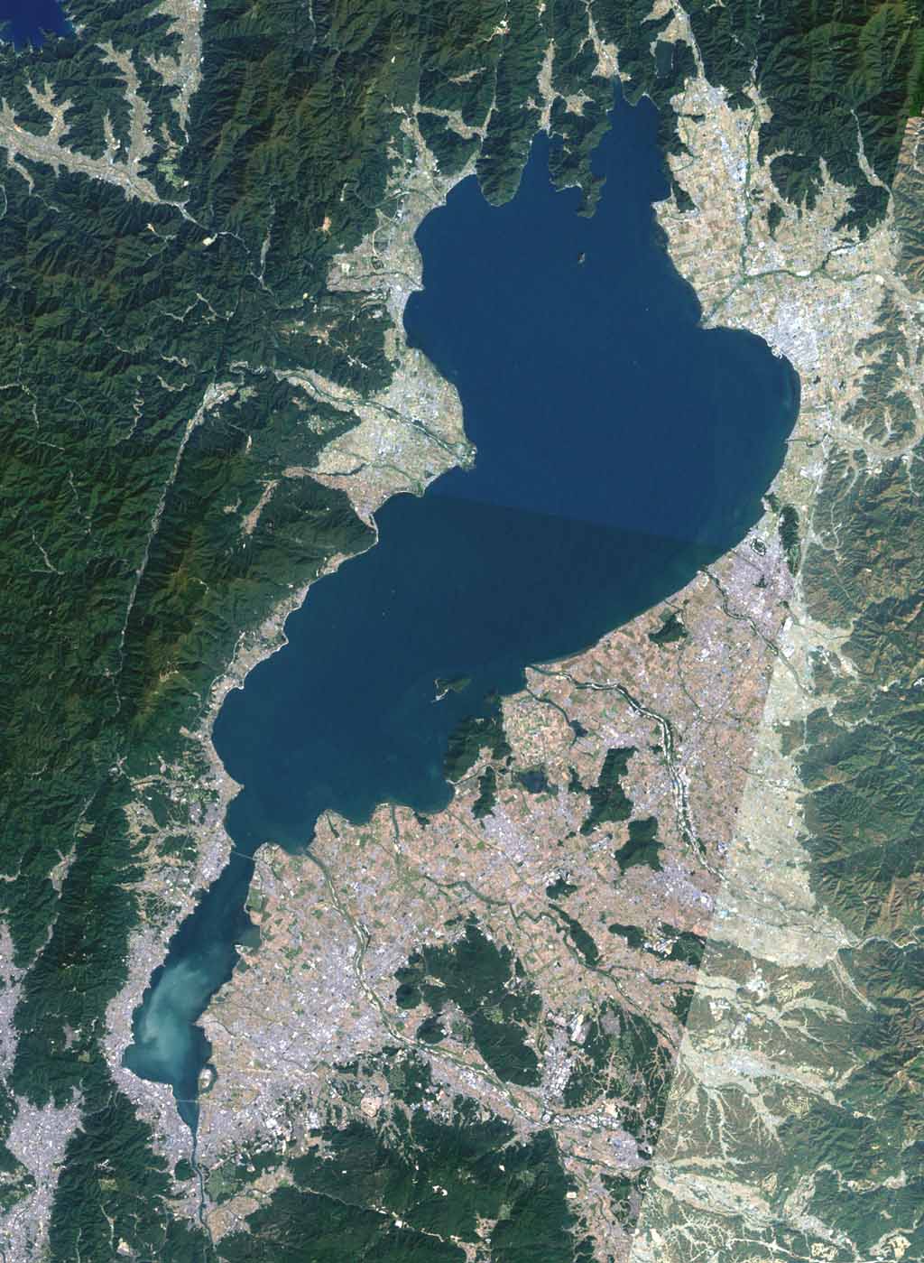
English: Landsat image of Lake Biwa. The narrow part at the bottom of the image is called "South Lake", and the large area above is called "North Lake".
แหล่งที่มา
The Landsat satellite pictures are used for this image. The data came from Global Land Cover Facility (GLCF), and are processed with Kashmir 3D.
ผู้สร้างสรรค์
Global Land Cover Facility (GLCF)
การอนุญาต (การใช้ไฟล์นี้ใหม่)
The Landsat satellite pictures are used for this image. The data came from Global Land Cover Facility (GLCF), and are processed with Kashmir 3D.
この画像には、ランドサット衛星画像が用いられています。これは、メリーランド大学 / Global Land Cover Facility 所蔵のデータにより、カシミール3Dにより画像化したものです。
ไฟล, lake, biwa, ไฟล, ประว, ไฟล, หน, าท, ภาพน, การใช, ไฟล, วนกลาง, อม, ลเก, ยวก, บภาพขนาดของต, วอย, างน, กเซล, ความละเอ, ยดอ, กเซล, กเซล, กเซล, กเซล, ภาพท, ความละเอ, ยดส, งกว, 8206, กเซล, ขนาดไฟล, โลไบต, ชน, ดไมม, image, jpeg, ปภาพหร, อไฟล, เส, ยงน, นฉบ, บอย, . ifl prawtiifl hnathimiphaphni karichiflswnklang khxmulekiywkbphaphkhnadkhxngtwxyangni 439 600 phikesl khwamlaexiydxun 176 240 phikesl 351 480 phikesl 562 768 phikesl 1 024 1 399 phikesl duphaphthimikhwamlaexiydsungkwa 8206 1 024 1 399 phikesl khnadifl 176 kiolibt chnidimm image jpeg rupphaphhruxiflesiyngni tnchbbxyuthi khxmmxns raylaexiyddanlang epnkhxkhwamthiaesdngphlcak ifltnchbbinkhxmmxns khxmmxnsepnewbistinokhrngkarsahrbekbrwbrwmsuxesri thi khunsamarthchwyid khwamyx khaxthibayLake biwa jpg 日本語 琵琶湖のランドサット画像 画面下側の細い部分が 南湖 その上に大きく広がっているのが 北湖 と呼ばれる水域 投稿者作成 下記参照 English Landsat image of Lake Biwa The narrow part at the bottom of the image is called South Lake and the large area above is called North Lake aehlngthima The Landsat satellite pictures are used for this image The data came from Global Land Cover Facility GLCF and are processed with Kashmir 3D phusrangsrrkh Global Land Cover Facility GLCF karxnuyat karichiflniihm The Landsat satellite pictures are used for this image The data came from Global Land Cover Facility GLCF and are processed with Kashmir 3D この画像には ランドサット衛星画像が用いられています これは メリーランド大学 Global Land Cover Facility 所蔵のデータにより カシミール3Dにより画像化したものです karxnuyatichsiththi xnuyatihkhdlxk aeckcayaela hruxddaeprexksarniphayitenguxnikhkhxngsyyaxnuyatexksaresrikhxngknu run 1 2 hruxrunid nbcaknithixxkodymulnithisxftaewresri odyimmiswnidhamaekikh immikhxkhwampkhnaaelapkhlng saenakhxngsyyaxnuyatrwmxyuinswnchux syyaxnuyatexksaresrikhxngknu thngni epniptamkhxptiesthkhwamrbphidchxbhttp www gnu org copyleft fdl html GFDL GNU Free Documentation License true trueiflnixyuphayitsyyaxnuyat khriexthifkhxmmxns aebbaesdngthima xnuyataebbediywkn 3 0 tnchbb thngni epniptamkhxptiesthkhwamrbphidchxbkhunsamarth thicaaebngpn thicathasaena aeckcay aelasngngandngklawtxip thicaeriyberiyngihm thicaddaeplngngandngklaw phayitenguxnikhtxipni aesdngthima khuntxngihekiyrtiecakhxngnganxyangehmaasm odyephimlingkipyngsyyaxnuyat aelarabuhakmikarepliynaeplng khunxacthaechnniidinrupaebbidkidtamkhwr aettxngimichinlksnathiaenawaphuihxnuyatsnbsnunkhunhruxkarichngankhxngkhun xnuyataebbediywkn hakkhunddaeplng epliynrup hruxtxetimnganni khuntxngichsyyaxnuyataebbediywknhruxaebbthiehmuxnkbsyyaxnuyatthiichkbnganniethannpayaesdngsthanalikhsiththinithukephimephuxihepniptamkarepliynaeplngsyyaxnuyatkhxngmulnithiwikimiediy cak GFDL ipyng GFDL khwbkhukb CC BY SA 3 0 http creativecommons org licenses by sa 3 0 CC BY SA 3 0 Creative Commons Attribution Share Alike 3 0 true truebnthukkarxphohld This file was moved from Japanese Wikipedia See below for original file information File name Lake biwa jpgDescription 琵琶湖のランドサット画像 画面下側の細い部分が 南湖 その上に大きく広がっているのが 北湖 と呼ばれる水域 File history wnthi ewla UTC khnad phuich khwamehn16 thnwakhm ph s 2548 13 59 1 024 1 399 Tdk 琵琶湖のランドサット画像 画面下側の細い部分が 南湖 その上に大きく広がっているのが 北湖 と呼ばれる水域 landsat Page history wnthi ewla UTC Flag phuich khwamyx 16 thnwakhm ph s 2548 13 59 Tdk 琵琶湖のランドサット画像 画面下側の細い部分が 南湖 その上に大きく広がっているのが 北湖 と呼ばれる水域 landsat 16 thnwakhm ph s 2548 14 19 Tdk9 kumphaphnth ph s 2549 14 20 l Bakkai カテゴリ編集 Deutsch English makedonski 한국어 日本語 فارسی khabrryayodyyxithyephimkhabrryaythrrthdediywephuxkhyaykhwamwaiflnimixairixethmthiaesdngxyuiniflniprakxbdwysthanalikhsiththimilikhsiththisyyaxnuyatGNU Free Documentation License version 1 2 or later xngkvsCreative Commons Attribution ShareAlike 3 0 Unported xngkvsMIME type xngkvsimage jpeg prawtiifl khlikwnthi ewlaephuxduiflthipraktinkhnann wnthi ewlarupyxkhnadphuichkhwamehn pccubn21 16 10 minakhm 25491 024 1 399 176 kiolibt Moja commonswikiLake Biwa in Japan The image is taken from ja 画像 Lake biwa jpg 20 59 16 thnwakhm 25481 024 1 399 176 kiolibt Tdk琵琶湖のランドサット画像 画面下側の細い部分が 南湖 その上に大きく広がっているのが 北湖 と呼ばれる水域 landsat hnathimiphaphni hnatxipni oyngmathiphaphni cnghwdchinga thaelsabbiwa karichiflswnklang wikixuntxipniichiflni karichbn ar wikipedia org بحيرة بيوا karichbn arz wikipedia org بحيره بيوا karichbn bat smg wikipedia org Bivas ezers karichbn be tarask wikipedia org Biva karichbn be wikipedia org Biva karichbn bg wikipedia org Biva ezero karichbn bs wikipedia org Biwa jezero karichbn ca wikipedia org Llac Biwa karichbn ceb wikipedia org Ōmi bonchi Biwa ko karichbn cs wikipedia org Biwa Prefektura Siga karichbn cv wikipedia org Biva kӳlĕ karichbn de wikipedia org Biwa See Liste japanischer Prafektursymbole karichbn el wikipedia org Limnh Mpiba karichbn en wikipedia org Shiga Prefecture Lake Biwa Wikipedia WikiProject Lakes Galleries 1 Water supply and sanitation in Japan karichbn en wikivoyage org Kansai Shiga karichbn es wikipedia org Prefectura de Shiga Lago Biwa karichbn eu wikipedia org Biwa aintzira karichbn fa wikipedia org دریاچه بیوا karichbn fr wikipedia org Lac Biwa karichbn he wikipedia org אגם ביווה karichbn he wikivoyage org קנסאי karichbn hr wikipedia org Biwa karichbn hu wikipedia org Biva to karichbn hy wikipedia org Բիվա լիճ karichbn id wikipedia org Danau Biwa karichbn incubator wikimedia org Wp ryu 琵琶湖 karichbn it wikipedia org Lago Biwa Politica dell acqua in Giappone karichbn ja wikipedia org 7月1日 琵琶湖 Lake Biwa 利用者 Tdk 近江盆地 Template Infobox 湖 内陸県 日本二十五勝 利用者 New Japan photo Template Infobox 湖 doc 滋賀県の市町村章一覧 近江の戦い 利用者 JuthaDDA sandbox 琵琶湖 karichbn ja wikibooks org 小学校社会 私たちの住む都道府県の特ちょう dukarichthwolkephimetimkhxngiflnikhxmulekiywkbphaph phaphnimikhxmulephimetim sungswnihymacakklxngdicitxlhruxsaeknenxrthisamarthekbkhxmuldngklawiwrwmkbphaphid thaphaphnithukprbprungaekikhhruxepliynaeplngcakedim khxmulbangxyangcayngkhngimepliynaeplngehmuxnphaphthithukprbprungaekikhnnkarcdwangphaphpktikhwamlaexiydaenwnxn72 dpikhwamlaexiydaenwtng72 dpisxftaewrthiichAdobe Photoshop CS Windowsaekikhphaphlasud22 51 16 thnwakhm 2548sepssisRGBkhwamkwangkhxngphaph1 024 phikeslkhwamsungkhxngphaph1 399 phikeslewlathiaeplngepndicithl07 51 17 thnwakhm 2548wnthiaekikhkhxmulemtalasud07 51 17 thnwakhm 2548 ekhathungcak https th wikipedia org wiki ifl Lake biwa jpg, wikipedia, วิกิ หนังสือ, หนังสือ, ห้องสมุด,