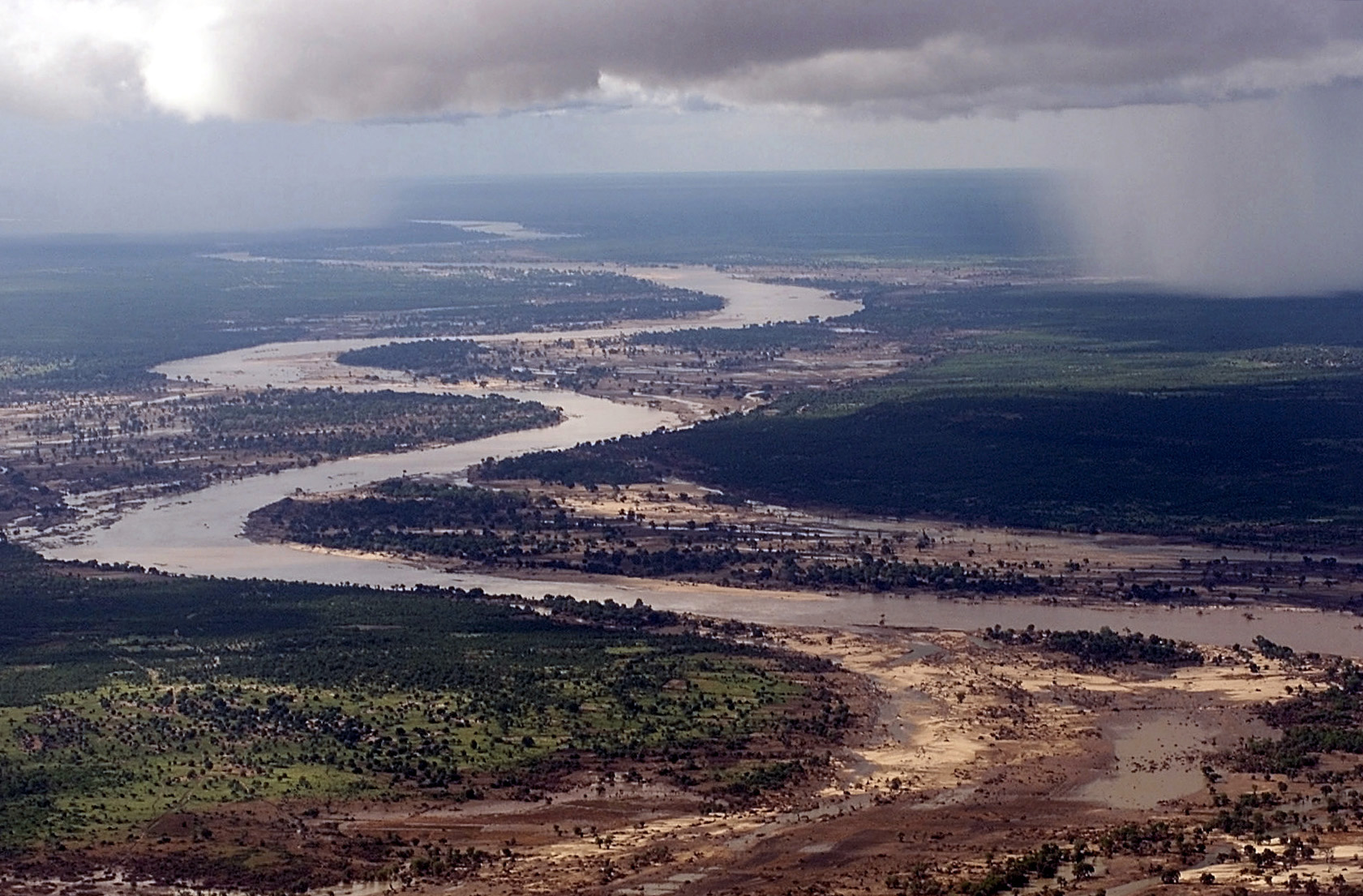
English: Aerial view, extreme long shot, looking down as the Limpopo River winds its way through Southern MOZAMBIQUE, where it recently crested its banks and sent floodwaters rushing through towns and farmland, forcing people from their homes and wreaking havoc with the country's infrastructure. Even though waters have receded over the past week, heavy rains seen in the distance, continue to threaten the region with more flooding. C-130 aircraft (not shown), assigned to the 37th Airlift Squadron at Ramstein Air Base, Germany, fly daily Keen Sage aerial surveillance missions over MOZAMBIQUE to rescue stranded flood victims and survey flood levels and damage caused by the flooding in Southern Africa. The 37th Airlift Squadron C-130 aircraft, deployed to Hoedspruit Air Force Base, South Africa, is part of the United States Operation Atlas Response humanitarian relief efforts.
วันที่
แหล่งที่มา
This media is available in the holdings of the National Archives and Records Administration, cataloged under the National Archives Identifier (NAID) 6512295.
This tag does not indicate the copyright status of the attached work. A normal copyright tag is still required.See Commons:Licensing.
العربية ∙ Deutsch ∙ English ∙ español ∙ français ∙ italiano ∙ 日本語 ∙ 한국어 ∙ македонски ∙ മലയാളം ∙ Nederlands ∙ polski ∙ português ∙ русский ∙ slovenščina ∙ Türkçe ∙ українська ∙ Tiếng Việt ∙ 中文(简体) ∙ 中文(繁體) ∙ +/−
ผู้สร้างสรรค์
TSgt Cary Humphries
การอนุญาต (การใช้ไฟล์นี้ใหม่)
Public domainPublic domainfalsefalse
บันทึกการอัพโหลด
date/time
username
resolution
size
edit summary
2006-05-01T21:56:31Z
User:Atamari
1681×1105
532.73Kb
{{Information| |Description={{en|Aerial view, extreme long shot, looking down as the Limpopo River winds its way through Southern MOZAMBIQUE, where it recently crested its banks and sent floodwaters rushing through towns and farmland, forcing people from
move approved by: User:Angr This image was moved from File:DF-SD-01-00934.jpg Category:Aerial photographs of Mozambique Category:Limpopo River {{Information| |Description={{en|Aerial view, extreme long shot, looking down as the Limpopo
ไฟล, limpopo, ไฟล, ประว, ไฟล, หน, าท, ภาพน, การใช, ไฟล, วนกลาง, อม, ลเก, ยวก, บภาพขนาดของต, วอย, างน, กเซล, ความละเอ, ยดอ, กเซล, กเซล, กเซล, กเซล, กเซล, ภาพท, ความละเอ, ยดส, งกว, 8206, กเซล, ขนาดไฟล, โลไบต, ชน, ดไมม, image, jpeg, ปภาพหร, อไฟล, เส, ยงน, นฉบ, บอ. ifl prawtiifl hnathimiphaphni karichiflswnklang khxmulekiywkbphaphkhnadkhxngtwxyangni 800 526 phikesl khwamlaexiydxun 320 210 phikesl 640 421 phikesl 1 024 673 phikesl 1 280 841 phikesl 1 681 1 105 phikesl duphaphthimikhwamlaexiydsungkwa 8206 1 681 1 105 phikesl khnadifl 533 kiolibt chnidimm image jpeg rupphaphhruxiflesiyngni tnchbbxyuthi khxmmxns raylaexiyddanlang epnkhxkhwamthiaesdngphlcak ifltnchbbinkhxmmxns khxmmxnsepnewbistinokhrngkarsahrbekbrwbrwmsuxesri thi khunsamarthchwyid khwamyx khaxthibayLimpopo jpg English Aerial view extreme long shot looking down as the Limpopo River winds its way through Southern MOZAMBIQUE where it recently crested its banks and sent floodwaters rushing through towns and farmland forcing people from their homes and wreaking havoc with the country s infrastructure Even though waters have receded over the past week heavy rains seen in the distance continue to threaten the region with more flooding C 130 aircraft not shown assigned to the 37th Airlift Squadron at Ramstein Air Base Germany fly daily Keen Sage aerial surveillance missions over MOZAMBIQUE to rescue stranded flood victims and survey flood levels and damage caused by the flooding in Southern Africa The 37th Airlift Squadron C 130 aircraft deployed to Hoedspruit Air Force Base South Africa is part of the United States Operation Atlas Response humanitarian relief efforts wnthi 10 minakhm ph s 2543aehlngthima This media is available in the holdings of the National Archives and Records Administration cataloged under the National Archives Identifier NAID 6512295 This tag does not indicate the copyright status of the attached work A normal copyright tag is still required See Commons Licensing العربية Deutsch English espanol francais italiano 日本語 한국어 makedonski മലയ ള Nederlands polski portugues russkij slovenscina Turkce ukrayinska Tiếng Việt 中文 简体 中文 繁體 phusrangsrrkh TSgt Cary Humphrieskarxnuyat karichiflniihm Public domain Public domain false falsephaphhruxsuxtxipnithayhruxcdthakhuninrahwangkarptibtihnathirachkarkhxngkharachkarpracakxngthphshrthxemrika hruxkharachkarpracakrathrwngklaohmshrthxemrika phaphhruxsuxdngklawcungcdepnngankhxngrthbalklangshrthxemrika aelathuxepnsatharnsmbtiduephimthi http www defenselink mil multimedia about html العربية catala cestina Deutsch Ellhnika English espanol eesti فارسی suomi francais galego ह न द hrvatski magyar italiano 日本語 한국어 makedonski മലയ ള Malti Nederlands polski portugues portugues do Brasil romană russkij sicilianu slovencina slovenscina srpski srpski ithy Turkce ukrayinska Tiếng Việt 中文 中文 简体 中文 繁體 bnthukkarxphohld date time username resolution size edit summary2006 05 01T21 56 31Z User Atamari 1681 1105 532 73Kb Information Description en Aerial view extreme long shot looking down as the Limpopo River winds its way through Southern MOZAMBIQUE where it recently crested its banks and sent floodwaters rushing through towns and farmland forcing people fromkhabrryayodyyxithyephimkhabrryaythrrthdediywephuxkhyaykhwamwaiflnimixairxngkvsLimpopoixethmthiaesdngxyuiniflniprakxbdwysthanalikhsiththisatharnsmbtiwnthisrang wnkxtng10 minakhm 2000 prawtiifl khlikwnthi ewlaephuxduiflthipraktinkhnann wnthi ewlarupyxkhnadphuichkhwamehn pccubn03 45 27 singhakhm 25521 681 1 105 533 kiolibt BetacommandBotmove approved by User Angr This image was moved from File DF SD 01 00934 jpg Category Aerial photographs of Mozambique Category Limpopo River Information Description en Aerial view extreme long shot looking down as the Limpopo hnathimiphaphni hnatxipni oyngmathiphaphni aemnalimopop karichiflswnklang wikixuntxipniichiflni karichbn af wikipedia org Limpopo rivier karichbn ar wikipedia org نهر ليمبوبو تاريخ الإقليم السواحلي karichbn arz wikipedia org نهر ليمبوبو karichbn ast wikipedia org Riu Limpopo karichbn azb wikipedia org چای جوغرافیا لیمپوپو چایی karichbn az wikipedia org Limpopo cayi karichbn bar wikipedia org Mosambik karichbn ba wikipedia org Limpopo karichbn be tarask wikipedia org Limpopa karichbn be wikipedia org Limpopa raka karichbn bg wikipedia org Limpopo karichbn bh wikipedia org ल म प प नद karichbn bn wikipedia org ল ম প প নদ karichbn br wikipedia org Limpopo karichbn br wiktionary org ster karichbn ca wikipedia org Limpopo karichbn ceb wikipedia org Limpopo River karichbn cs wikipedia org Limpopo karichbn cy wikipedia org Afon Limpopo karichbn de wikipedia org Limpopo Fluss Liste von Flussen in Mosambik Biodiversitats Hotspot Kustenwalder Ostafrikas karichbn el wikipedia org Limpopo karichbn en wikipedia org Limpopo River Natural disaster Cyclone Leon Eline User talk Debresser Archive 2 Bosutswe karichbn en wikiquote org Rivers karichbn en wikiversity org Draft Original research Geophysics Draft Keynote lectures Hydromorphology Hydrology Quiz Radiation Meteors User Marshallsumter Radiation astronomy1 Hydrometeors Korean Words Hotspots Korean Words 가르다 Korean Words ㄱ Geominerals Oxidanes karichbn en wiktionary org river kuri მდინარე riu ܢܗܪܐ karichbn eo wikipedia org Naturkatastrofo Limpopo Suda zanzibara inhambana marborda arbarmozaiko karichbn es wikipedia org Mozambique dukarichthwolkephimetimkhxngiflnikhxmulekiywkbphaph phaphnimikhxmulephimetim sungswnihymacakklxngdicitxlhruxsaeknenxrthisamarthekbkhxmuldngklawiwrwmkbphaphid thaphaphnithukprbprungaekikhhruxepliynaeplngcakedim khxmulbangxyangcayngkhngimepliynaeplngehmuxnphaphthithukprbprungaekikhnn error0 ekhathungcak https th wikipedia org wiki ifl Limpopo jpg, wikipedia, วิกิ หนังสือ, หนังสือ, ห้องสมุด,