This file is licensed under the Creative Commons Attribution-Share Alike 4.0 International, 3.0 Unported, 2.5 Generic, 2.0 Generic and 1.0 Generic license.
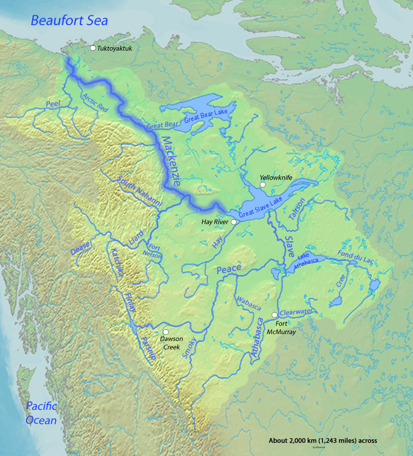
{{Information |Description={{en|1=Map of the Mackenzie River, second greatest river in North America, that drains to the Arctic Ocean}} |Source=Background and river course data from http://www2.demis.nl/mapserver/mapper.asp, river names mostly thanks to [
ไฟล, mackenzierivermap, ไฟล, ประว, ไฟล, หน, าท, ภาพน, การใช, ไฟล, วนกลาง, อม, ลเก, ยวก, บภาพขนาดของต, วอย, างน, กเซล, ความละเอ, ยดอ, กเซล, กเซล, กเซล, ภาพท, ความละเอ, ยดส, งกว, 8206, กเซล, ขนาดไฟล, โลไบต, ชน, ดไมม, image, jpeg, ปภาพหร, อไฟล, เส, ยงน, นฉบ, บอย,. ifl prawtiifl hnathimiphaphni karichiflswnklang khxmulekiywkbphaphkhnadkhxngtwxyangni 542 599 phikesl khwamlaexiydxun 217 240 phikesl 434 480 phikesl 839 928 phikesl duphaphthimikhwamlaexiydsungkwa 8206 839 928 phikesl khnadifl 412 kiolibt chnidimm image jpeg rupphaphhruxiflesiyngni tnchbbxyuthi khxmmxns raylaexiyddanlang epnkhxkhwamthiaesdngphlcak ifltnchbbinkhxmmxns khxmmxnsepnewbistinokhrngkarsahrbekbrwbrwmsuxesri thi khunsamarthchwyid khwamyx khaxthibayMackenzierivermap jpg English Map of the Mackenzie River second greatest river in North America that drains to the Arctic Oceanwnthi 4 minakhm ph s 2553aehlngthima Background and river course data from http www2 demis nl mapserver mapper asp river names mostly thanks to Image Major Rivers in West Canada pngphusrangsrrkh Shannon karxnuyatichsiththi khapheca inthanaphuthuxlikhsiththikhxngphaphhruxsuxni xnuyatihichphaphhruxsuxniphayitenguxnikhtxipni xnuyatihkhdlxk aeckcayaela hruxddaeprexksarniphayitenguxnikhkhxngsyyaxnuyatexksaresrikhxngknu run 1 2 hruxrunid nbcaknithixxkodymulnithisxftaewresri odyimmiswnidhamaekikh immikhxkhwampkhnaaelapkhlng saenakhxngsyyaxnuyatrwmxyuinswnchux syyaxnuyatexksaresrikhxngknuhttp www gnu org copyleft fdl html GFDL GNU Free Documentation License true trueThis file is licensed under the Creative Commons Attribution Share Alike 4 0 International 3 0 Unported 2 5 Generic 2 0 Generic and 1 0 Generic license khunsamarth thicaaebngpn thicathasaena aeckcay aelasngngandngklawtxip thicaeriyberiyngihm thicaddaeplngngandngklaw phayitenguxnikhtxipni aesdngthima khuntxngihekiyrtiecakhxngnganxyangehmaasm odyephimlingkipyngsyyaxnuyat aelarabuhakmikarepliynaeplng khunxacthaechnniidinrupaebbidkidtamkhwr aettxngimichinlksnathiaenawaphuihxnuyatsnbsnunkhunhruxkarichngankhxngkhun xnuyataebbediywkn hakkhunddaeplng epliynrup hruxtxetimnganni khuntxngichsyyaxnuyataebbediywknhruxaebbthiehmuxnkbsyyaxnuyatthiichkbnganniethannhttps creativecommons org licenses by sa 4 0 CC BY SA 4 0 Creative Commons Attribution Share Alike 4 0 true truekhunsamartheluxksyyaxnuyatdngklawtamtxngkarkhabrryayodyyxithyephimkhabrryaythrrthdediywephuxkhyaykhwamwaiflnimixairixethmthiaesdngxyuiniflniprakxbdwyphusrangbangkhathiimmiixethmwikisnethschuxphuichwikimiediy Shannonchanchuxphusrangsrrkh Shannonyuxaraexl https commons wikimedia org wiki user ShannonchansthanalikhsiththimilikhsiththisyyaxnuyatCreative Commons Attribution ShareAlike 1 0 Generic xngkvsCreative Commons Attribution ShareAlike 2 0 Generic xngkvsGNU Free Documentation License version 1 2 or later xngkvsCreative Commons Attribution ShareAlike 2 5 Generic xngkvsCreative Commons Attribution ShareAlike 4 0 International xngkvsCreative Commons Attribution ShareAlike 3 0 Unported xngkvswnthisrang wnkxtng4 minakhm 2010 prawtiifl khlikwnthi ewlaephuxduiflthipraktinkhnann wnthi ewlarupyxkhnadphuichkhwamehn pccubn10 56 5 minakhm 2553839 928 412 kiolibt Shannon1Added scale etc 10 52 5 minakhm 2553839 928 408 kiolibt Shannon1 Information Description en 1 Map of the Mackenzie River second greatest river in North America that drains to the Arctic Ocean Source Background and river course data from http www2 demis nl mapserver mapper asp river names mostly thanks to hnathimiphaphni hnatxipni oyngmathiphaphni aemnaaemkekhnsi karichiflswnklang wikixuntxipniichiflni karichbn af wikipedia org Mackenzierivier karichbn ar wikipedia org نهر ماكينزي karichbn ast wikipedia org Gran Llagu del Esclavu karichbn ba wikipedia org Makkenzi jylga karichbn be tarask wikipedia org Makenzi raka karichbn be wikipedia org Makenzi karichbn bg wikipedia org Makkenzi Reki v Kanada Liard Fort Nelsn reka Pijl reka Arktik Red Rivr karichbn da wikipedia org Canadas laengste floder Mackenzie River karichbn el wikipedia org Potamos Makenzi karichbn en wikipedia org Boats of the Mackenzie River watershed Canadian canoe routes Blachford Lake User Kayoty sandbox karichbn es wikipedia org Rio Mackenzie Gran Lago del Esclavo Gran Lago del Oso Alexander MacKenzie Rio Athabasca Lago Athabasca Rio de la Paz Canada Rio de los Esclavos Rio Finlay Rio Liard Rio South Nahanni Primeras rutas canadienses en canoa Rio Peel Canada Lago Claire Pequeno Lago de los Esclavos Lago Hottah Rio Coal Rio Omineca Portaje Methye Rio Clearwater Saskatchewan Rio Hay Rio Arctic Red Rio Pembina karichbn fa wikipedia org رود مکنزی karichbn he wikipedia org מקנזי נהר karichbn hr wikipedia org Mackenzie karichbn hu wikipedia org Mackenzie folyo karichbn io wikipedia org Fluvio Mackenzie karichbn is wikipedia org Mackenziefljot karichbn it wikipedia org Mackenzie Peel fiume Canada dukarichthwolkephimetimkhxngiflnikhxmulekiywkbphaph phaphnimikhxmulephimetim sungswnihymacakklxngdicitxlhruxsaeknenxrthisamarthekbkhxmuldngklawiwrwmkbphaphid thaphaphnithukprbprungaekikhhruxepliynaeplngcakedim khxmulbangxyangcayngkhngimepliynaeplngehmuxnphaphthithukprbprungaekikhnnkarcdwangphaphpktikhwamlaexiydaenwnxn72 dpikhwamlaexiydaenwtng72 dpisxftaewrthiichAdobe Photoshop Elements 6 0 Macintoshaekikhphaphlasud19 56 4 minakhm 2553sepssisRGB ekhathungcak https th wikipedia org wiki ifl Mackenzierivermap jpg, wikipedia, วิกิ หนังสือ, หนังสือ, ห้องสมุด,