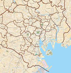
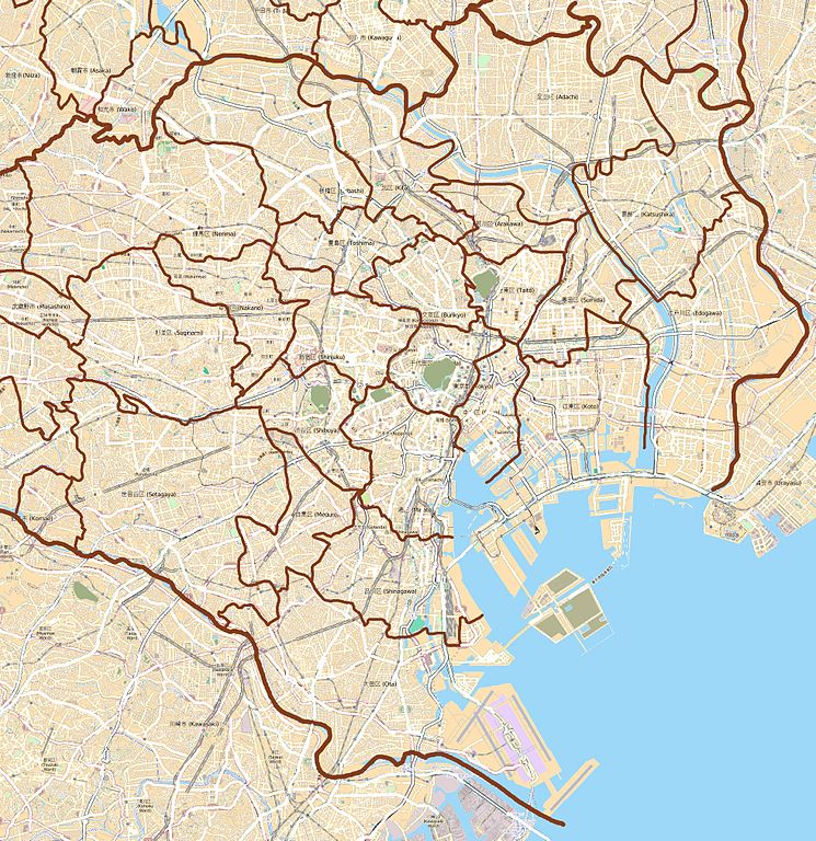
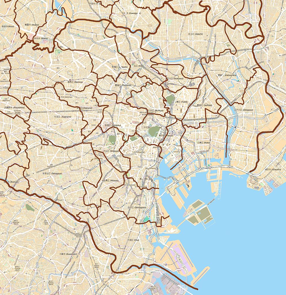
English: Map of the 23 special wards of Tokyo, Japan
Français : Carte des 23 arrondissements spéciaux de Tokyo, Japon
was created from OpenStreetMap project data, collected by the community. This map may be incomplete, and may contain errors. Don't rely solely on it for navigation.
วันที่
(see file history)
แหล่งที่มา
openstreetmap.org
ผู้สร้าง
XIIIfromTOKYO
การอนุญาต (การใช้ไฟล์นี้ใหม่)
OpenStreetMap data and maps are licensed under the Creative Commons Attribution-ShareAlike 2.0 license (CC-BY-SA 2.0).
This work contains information from OpenStreetMap, which is made available under the Open Database License (ODbL).
The ODbL does not require any particular license for maps produced from ODbL data. Prior to 1 August 2020, map tiles produced by the OpenStreetMap Foundation were licensed under the CC-BY-SA-2.0 license. Maps produced by other people may be subject to other licences.Open Database LicenseODbLhttp://opendatacommons.org/licenses/odbl/1.0/true
{{Information |Description ={{en|1=Map of the 23 special wards of Tokyo, Japan}} {{fr|1=Carte des 23 arrondissements spéciaux de Tokyo, Japon}} |Source ={{openstreetmap}} |Author =OpenStreetMap contributors |Date =2012-02-04
ไฟล, tokyo, special, wards, ไฟล, ประว, ไฟล, หน, าท, ภาพน, การใช, ไฟล, วนกลางขนาดของต, วอย, างน, กเซล, ความละเอ, ยดอ, กเซล, กเซล, กเซล, กเซล, กเซล, ภาพท, ความละเอ, ยดส, งกว, 8206, กเซล, ขนาดไฟล, เมกะไบต, ชน, ดไมม, image, jpeg, ปภาพหร, อไฟล, เส, ยงน, นฉบ, บอย, ค. ifl prawtiifl hnathimiphaphni karichiflswnklangkhnadkhxngtwxyangni 582 600 phikesl khwamlaexiydxun 233 240 phikesl 466 480 phikesl 745 768 phikesl 994 1 024 phikesl 1 963 2 023 phikesl duphaphthimikhwamlaexiydsungkwa 8206 1 963 2 023 phikesl khnadifl 4 48 emkaibt chnidimm image jpeg rupphaphhruxiflesiyngni tnchbbxyuthi khxmmxns raylaexiyddanlang epnkhxkhwamthiaesdngphlcak ifltnchbbinkhxmmxns khxmmxnsepnewbistinokhrngkarsahrbekbrwbrwmsuxesri thi khunsamarthchwyid khwamyx khaxthibayMap Tokyo special wards jpg This map of English Map of the 23 special wards of Tokyo Japan Francais Carte des 23 arrondissements speciaux de Tokyo Japon was created from OpenStreetMap project data collected by the community This map may be incomplete and may contain errors Don t rely solely on it for navigation wnthi see file history aehlngthima openstreetmap orgphusrang XIIIfromTOKYOkarxnuyat karichiflniihm OpenStreetMap data and maps are licensed under the Creative Commons Attribution ShareAlike 2 0 license CC BY SA 2 0 iflnixyuphayitsyyaxnuyat khriexthifkhxmmxns aebbaesdngthima xnuyataebbediywkn 2 0 thwipkhunsamarth thicaaebngpn thicathasaena aeckcay aelasngngandngklawtxip thicaeriyberiyngihm thicaddaeplngngandngklaw phayitenguxnikhtxipni aesdngthima khuntxngihekiyrtiecakhxngnganxyangehmaasm odyephimlingkipyngsyyaxnuyat aelarabuhakmikarepliynaeplng khunxacthaechnniidinrupaebbidkidtamkhwr aettxngimichinlksnathiaenawaphuihxnuyatsnbsnunkhunhruxkarichngankhxngkhun xnuyataebbediywkn hakkhunddaeplng epliynrup hruxtxetimnganni khuntxngichsyyaxnuyataebbediywknhruxaebbthiehmuxnkbsyyaxnuyatthiichkbnganniethannhttps creativecommons org licenses by sa 2 0 CC BY SA 2 0 Creative Commons Attribution Share Alike 2 0 true true Geotemporal datakhxbekht N 35 821 NW 139 555 E E 139 923 ES 35 513 Nphikdxangxingthangphumisastr rabuphikdbnaephnthi Wikimaps Warper thamikhwamimehmaasm krunatng warp status skip ephuxsxn karxnuyatichsiththi khapheca inthanaphuthuxlikhsiththikhxngphaphhruxsuxni xnuyatihichphaphhruxsuxniphayitenguxnikhtxipniiflnixyuphayitsyyaxnuyat khriexthifkhxmmxns aebbaesdngthima xnuyataebbediywkn 3 0 tnchbbkhunsamarth thicaaebngpn thicathasaena aeckcay aelasngngandngklawtxip thicaeriyberiyngihm thicaddaeplngngandngklaw phayitenguxnikhtxipni aesdngthima khuntxngihekiyrtiecakhxngnganxyangehmaasm odyephimlingkipyngsyyaxnuyat aelarabuhakmikarepliynaeplng khunxacthaechnniidinrupaebbidkidtamkhwr aettxngimichinlksnathiaenawaphuihxnuyatsnbsnunkhunhruxkarichngankhxngkhun xnuyataebbediywkn hakkhunddaeplng epliynrup hruxtxetimnganni khuntxngichsyyaxnuyataebbediywknhruxaebbthiehmuxnkbsyyaxnuyatthiichkbnganniethannhttps creativecommons org licenses by sa 3 0 CC BY SA 3 0 Creative Commons Attribution Share Alike 3 0 true true This work contains information from OpenStreetMap which is made available under the Open Database License ODbL The ODbL does not require any particular license for maps produced from ODbL data Prior to 1 August 2020 map tiles produced by the OpenStreetMap Foundation were licensed under the CC BY SA 2 0 license Maps produced by other people may be subject to other licences Open Database License ODbL http opendatacommons org licenses odbl 1 0 truekhabrryayodyyxithyephimkhabrryaythrrthdediywephuxkhyaykhwamwaiflnimixairixethmthiaesdngxyuiniflniprakxbdwysthanalikhsiththimilikhsiththisyyaxnuyatCreative Commons Attribution ShareAlike 2 0 Generic xngkvsCreative Commons Attribution ShareAlike 3 0 Unported xngkvs prawtiifl khlikwnthi ewlaephuxduiflthipraktinkhnann wnthi ewlarupyxkhnadphuichkhwamehn pccubn22 45 19 krkdakhm 25551 963 2 023 4 48 emkaibt XIIIfromTOKYOcolors 02 56 5 kumphaphnth 25551 963 2 023 4 56 emkaibt XIIIfromTOKYOColors 01 06 5 kumphaphnth 25551 963 2 023 1 47 emkaibt XIIIfromTOKYO Information Description en 1 Map of the 23 special wards of Tokyo Japan fr 1 Carte des 23 arrondissements speciaux de Tokyo Japon Source openstreetmap Author OpenStreetMap contributors Date 2012 02 04 hnathimiphaphni immihnaidoyngmathiphaphnikarichiflswnklang wikixuntxipniichiflni karichbn ar wikipedia org قالب Location map Tokyo city karichbn bg wikipedia org Nacionalen muzej na zapadnoto izkustvo Shablon PK Tokio karichbn ca wikipedia org Districtes especials de Toquio karichbn ceb wikipedia org Plantilya Location map Tokyo city karichbn en wikipedia org Akihabara Roppongi Shibuya Harajuku Tokyo Station Ōsaki Station Shinagawa Station Tamachi Station Tokyo Hamamatsuchō Station Harajuku Station Shinjuku Station Yurakuchō Station Gotanda Station Meguro Station Ebisu Station Tokyo Ueno Station Ikebukuro Station Shibuya Station Shimbashi Station Yoyogi Station Okachimachi Station Akihabara Station Kanda Station Tokyo Nakano Station Tokyo Ochanomizu Station Iidabashi Station Takadanobaba Station Kyōbashi Station Tokyo Kabukichō Mejiro Station Nishi Nippori Station Nippori Station Shin Ōkubo Station Ōtsuka Station Sugamo Station Komagome Station Futako Tamagawa Station Tennōzu Isle Station Hiroo Station Daikan yama Station Nezu Station Kamezuka Park Ōtemachi Station Tokyo Ogikubo Station Tsunashima Station dukarichthwolkephimetimkhxngiflni ekhathungcak https th wikipedia org wiki ifl Map Tokyo special wards jpg, wikipedia, วิกิ หนังสือ, หนังสือ, ห้องสมุด,